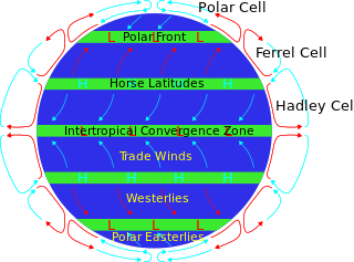
The horse latitudes are the latitudes about 30 degrees north and south of the Equator. They are characterized by sunny skies, calm winds, and very little precipitation. They are also known as subtropical ridges or highs. It is a high-pressure area at the divergence of trade winds and the westerlies.

A subtropical cyclone is a weather system that has some characteristics of both tropical and an extratropical cyclone.

An Anticyclone is a weather phenomenon defined as a large-scale circulation of winds around a central region of high atmospheric pressure, clockwise in the Northern Hemisphere and counterclockwise in the Southern Hemisphere as viewed from above. Effects of surface-based anticyclones include clearing skies as well as cooler, drier air. Fog can also form overnight within a region of higher pressure.

A Mediterranean climate, also called a dry summer climate, described by Köppen as Cs, is a temperate climate type that occurs in the lower mid-latitudes. Such climates typically have dry summers and wet winters, with summer conditions ranging from warm to hot and winter conditions typically being mild. These weather conditions are typically experienced in the majority of Mediterranean-climate regions and countries, but remain highly dependent on proximity to the ocean, altitude and geographical location.

The subtropical zones or subtropics are geographical and climate zones to the north and south of the tropics. Geographically part of the temperate zones of both hemispheres, they cover the middle latitudes from 23°26′10.4″ (or 23.43623°) to approximately 35° north and south. The horse latitudes lie within this range.
A high-pressure area, high, or anticyclone, is an area near the surface of a planet where the atmospheric pressure is greater than the pressure in the surrounding regions. Highs are middle-scale meteorological features that result from interplays between the relatively larger-scale dynamics of an entire planet's atmospheric circulation.

The trade winds or easterlies are the permanent east-to-west prevailing winds that flow in the Earth's equatorial region. The trade winds blow mainly from the northeast in the Northern Hemisphere and from the southeast in the Southern Hemisphere, strengthening during the winter and when the Arctic oscillation is in its warm phase. Trade winds have been used by captains of sailing ships to cross the world's oceans for centuries. They enabled colonial expansion into the Americas, and trade routes to become established across the Atlantic Ocean and the Pacific Ocean.

In oceanography, a gyre is any large system of circulating ocean surface currents, particularly those involved with large wind movements. Gyres are caused by the Coriolis effect; planetary vorticity, horizontal friction and vertical friction determine the circulatory patterns from the wind stress curl (torque).

Cuyo is the wine-producing, mountainous region of central-west Argentina. Historically it comprised the provinces of San Juan, San Luis and Mendoza. The modern New Cuyo includes both Cuyo proper and the province of La Rioja. New Cuyo is a political and economic macroregion, but culturally La Rioja is part of the North-West rather than of Cuyo.

Blocks in meteorology are large-scale patterns in the atmospheric pressure field that are nearly stationary, effectively "blocking" or redirecting migratory cyclones. They are also known as blocking highs or blocking anticyclones. These blocks can remain in place for several days or even weeks, causing the areas affected by them to have the same kind of weather for an extended period of time. In the Northern Hemisphere, extended blocking occurs most frequently in the spring over the eastern Pacific and Atlantic Oceans. Whilst these events are linked to the occurrence of extreme weather events such as heat waves, particularly the onset and decay of these events is still not well captured in numerical weather forecasts and remains an open area of research.

The geography of South America contains many diverse regions and climates. Geographically, South America is generally considered a continent forming the southern portion of the landmass of the Americas, south and east of the Colombia–Panama border by most authorities, or south and east of the Panama Canal by some. South and North America are sometimes considered a single continent or supercontinent, while constituent regions are infrequently considered subcontinents.
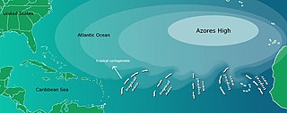
The Azores High also known as North Atlantic (Subtropical) High/Anticyclone or the Bermuda-Azores High, is a large subtropical semi-permanent centre of high atmospheric pressure typically found south of the Azores in the Atlantic Ocean, at the Horse latitudes. It forms one pole of the North Atlantic oscillation, the other being the Icelandic Low. The system influences the weather and climatic patterns of vast areas of North Africa, Western Asia, Southern Europe, and to a lesser extent, eastern North America. The aridity of the Sahara Desert and the summer drought of the Mediterranean Basin is due to the large-scale subsidence and sinking motion of air in the system. In its summer position, the high is centered near Bermuda, and creates a southwest flow of warm tropical air toward the East Coast of the United States. In summer, the Azores-Bermuda High is strongest. The central pressure hovers around 1024 mbar (hPa).

The climate of the United States varies due to changes in latitude, and a range of geographic features, including mountains and deserts. Generally, on the mainland, the climate of the U.S. becomes warmer the further south one travels, and drier the further west, until one reaches the West Coast.

The climate of Argentina varies from region to region, as the vast size of the country and wide variation in altitude make for a wide range of climate types. Summers are the warmest and wettest season in most of Argentina except in most of Patagonia where it is the driest season. Warm in the north, cool in the center and cold in the southern parts experiencing frequent frost and snow. Because southern parts of the country are moderated by the surrounding oceans, the cold is less intense and prolonged than areas at similar latitudes in the northern hemisphere. Spring and autumn are transition seasons that generally feature mild weather.

A humid subtropical climate is a temperate climate type characterized by hot and humid summers, and cool to mild winters. These climates normally lie on the southeast side of all continents, generally between latitudes 25° and 40° and are located poleward from adjacent tropical climates. It is also known as warm temperate climate in some climate classifications.
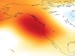
The "Ridiculously Resilient Ridge", sometimes shortened to "Triple R" or "RRR", is the nickname given to a persistent anticyclone that occurred over the far northeastern Pacific Ocean, contributing to the 2011–2017 California drought. The "Ridiculously Resilient Ridge" nickname was originally coined in December 2013 by Daniel Swain on the Weather West Blog, but has since been used widely in popular media as well as in peer-reviewed scientific literature.

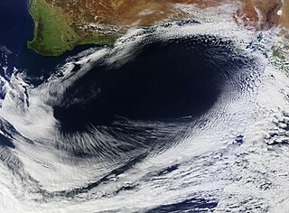
The Blob is a large mass of relatively warm water in the Pacific Ocean off the coast of North America that was first detected in late 2013 and continued to spread throughout 2014 and 2015. It is an example of a marine heatwave. Sea surface temperatures indicated that the Blob persisted into 2016, but it was initially thought to have dissipated later that year.
Centers of action are extensive and almost stationary low or high pressure areas which control the movement of atmospheric disturbances over a large area. This does not mean that the position of the center is constant over a specific area but that the monthly atmospheric pressure corresponds to a high or a low pressure.

The 2011–2017 California drought persisted from December 2011 to March 2017 and consisted of the driest period in California's recorded history, late 2011 through 2014. The drought wiped out 102 million trees from 2011 to 2016, 62 million of those during 2016 alone. The cause of the drought was attributed to a ridge of high pressure in the Pacific Sea—the "Ridiculously Resilient Ridge"—which often barred powerful winter storms from reaching the state.
The Australian High, also known as the Australian subtropical ridge, is a large, semi-permanent high pressure area or subtropical anticyclone that seasonally vacillates between the Great Australian Bight in the south to the Northern Territory in the north. It is generally located between 25 and 40 degrees of south latitude, depending on the season.

