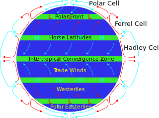
The horse latitudes are the latitudes about 30 degrees north and south of the Equator. They are characterized by sunny skies, calm winds, and very little precipitation. They are also known as subtropical ridges or highs. It is a high-pressure area at the divergence of trade winds and the westerlies.

An anticyclone is a weather phenomenon defined as a large-scale circulation of winds around a central region of high atmospheric pressure, clockwise in the Northern Hemisphere and counterclockwise in the Southern Hemisphere as viewed from above. Effects of surface-based anticyclones include clearing skies as well as cooler, drier air. Fog can also form overnight within a region of higher pressure.

A Mediterranean climate, also called a dry summer climate, described by Köppen as Cs, is a temperate climate type that occurs in the lower mid-latitudes. Such climates typically have dry summers and wet winters, with summer conditions ranging from warm to hot and winter conditions typically being mild to cool. These weather conditions are typically experienced in the majority of Mediterranean-climate regions and countries, but remain highly dependent on proximity to the ocean, altitude and geographical location.

The subtropical zones or subtropics are geographical and climate zones to the north and south of the tropics. Geographically part of the temperate zones of both hemispheres, they cover the middle latitudes from 23°26′10.1″ (or 23.43613°) to approximately 35° north and south. The horse latitudes lie within this range.
A high-pressure area, high, or anticyclone, is an area near the surface of a planet where the atmospheric pressure is greater than the pressure in the surrounding regions. Highs are middle-scale meteorological features that result from interplays between the relatively larger-scale dynamics of an entire planet's atmospheric circulation.
The Siberian High is a massive collection of cold dry air that accumulates in the northeastern part of Eurasia from September until April. It is usually centered on Lake Baikal. It reaches its greatest size and strength in the winter when the air temperature near the center of the high-pressure area is often lower than −40 °C (−40 °F). The atmospheric pressure is often above 1,040 millibars (31 inHg). The Siberian High is the strongest semi-permanent high in the northern hemisphere and is responsible for both the lowest temperature in the Northern Hemisphere outside Greenland, of −67.8 °C (−90.0 °F) on 15 January 1885 at Verkhoyansk, and the highest pressure, 1083.8 mbar at Agata, Krasnoyarsk Krai, on 31 December 1968, ever recorded. The Siberian High is responsible both for severe winter cold and attendant dry conditions with little snow and few or no glaciers across Asian part of Russia, Mongolia, and China. During the summer, the Siberian High is largely replaced by the Asiatic low.

In meteorology a ridge or barometric ridge is an elongated area of relatively high atmospheric pressure compared to the surrounding environment, without being a closed circulation. It is associated with an area of maximum anticyclonic curvature of wind flow. The ridge originates in the center of an anticyclone and sandwiched between two low-pressure areas, and the locus of the maximum curvature is called the ridge line. This phenomenon is the opposite of a trough.
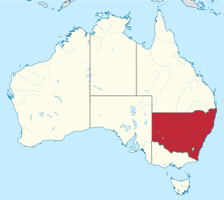
New South Wales is Australia's most populous state, located in the east coast of the continent. It is in the southern hemisphere between latitudes 28 and 38 degrees south of the equator and longitudes 141 and 154 degrees east of the Universal Prime Meridian. The state is in the warm temperate climatic zone.

Blocks in meteorology are large-scale patterns in the atmospheric pressure field that are nearly stationary, effectively "blocking" or redirecting migratory cyclones. They are also known as blocking highs or blocking anticyclones. These blocks can remain in place for several days or even weeks, causing the areas affected by them to have the same kind of weather for an extended period of time. In the Northern Hemisphere, extended blocking occurs most frequently in the spring over the eastern Pacific and Atlantic Oceans. Whilst these events are linked to the occurrence of extreme weather events such as heat waves, particularly the onset and decay of these events is still not well captured in numerical weather forecasts and remains an open area of research.

The geography of South America contains many diverse regions and climates. Geographically, South America is generally considered a continent forming the southern portion of the landmass of the Americas, south and east of the Colombia–Panama border by most authorities, or south and east of the Panama Canal by some. South and North America are sometimes considered a single continent or supercontinent, while constituent regions are infrequently considered subcontinents.
The climate of Sydney, Australia is humid subtropical, shifting from mild and cool in winter to warm and occasionally hot in the summer, with no extreme seasonal differences as the weather is moderated by proximity to the ocean, although more contrasting temperatures are recorded in the inland western suburbs. Despite the fact that there is no distinct dry or wet season, rainfall peaks during summer and autumn months, and is at its lowest just around the middle of the year, though precipitation can be erratic throughout the year. Precipitation varies across the region, with areas adjacent to the coast being the wettest. According to the Bureau of Meteorology, Sydney falls in the temperate climate zone which has warm to hot summers and no dry season. Sydney's plant hardiness zone ranges from zone 11a to 9b throughout the metropolitan area. Under the Holdridge Life Zones classification, eastern Sydney falls in the Subtropical Moist Forest zone and the western suburbs in the Subtropical Dry Forest zone.
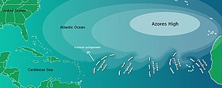
The Azores High also known as North Atlantic (Subtropical) High/Anticyclone or the Bermuda-Azores High, is a large subtropical semi-permanent centre of high atmospheric pressure typically found south of the Azores in the Atlantic Ocean, at the Horse latitudes. It forms one pole of the North Atlantic oscillation, the other being the Icelandic Low. The system influences the weather and climatic patterns of vast areas of North Africa, Western Asia, Southern Europe, and to a lesser extent, eastern North America. The aridity of the Sahara Desert and the summer drought of the Mediterranean Basin is due to the large-scale subsidence and sinking motion of air in the system. In its summer position, the high is centered near Bermuda, and creates a southwest flow of warm tropical air toward the East Coast of the United States. In summer, the Azores-Bermuda High is strongest. The central pressure hovers around 1024 mbar (hPa).

The North American monsoon, variously known as the Southwest monsoon, the Mexican monsoon, the New Mexican monsoon, or the Arizona monsoon is a pattern of pronounced increase in thunderstorms and rainfall over large areas of the southwestern United States and northwestern Mexico, centered roughly on the Rio Grande Valley, and typically occurring between June and mid-September. During the monsoon, thunderstorms are fueled by daytime heating and build up during the late afternoon and early evening. Typically, these storms dissipate by late night, and the next day starts out fair, with the cycle repeating daily. The monsoon typically loses its energy by mid-September when much drier conditions are reestablished over the region. Geographically, the North American monsoon precipitation region is centered over the Sierra Madre Occidental in the Mexican states of Sinaloa, Durango, Sonora and Chihuahua.

A humid subtropical climate is a temperate climate type characterized by hot and humid summers, and cool to mild winters. These climates normally lie on the southeast side of all continents, generally between latitudes 25° and 40° and are located poleward from adjacent tropical climates, and equatorward from either humid continental or oceanic climates. It is also known as warm temperate climate in some climate classifications.

A cold-core low, also known as an upper level low or cold-core cyclone, is a cyclone aloft which has an associated cold pool of air residing at high altitude within the Earth's troposphere, without a frontal structure. It is a low pressure system that strengthens with height in accordance with the thermal wind relationship. If a weak surface circulation forms in response to such a feature at subtropical latitudes of the eastern north Pacific or north Indian oceans, it is called a subtropical cyclone. Cloud cover and rainfall mainly occurs with these systems during the day.

Melbourne, the state capital of Victoria and the second most populous city in Australia, has a temperate oceanic climate and is well known for its changeable weather conditions. This is mainly due to Melbourne's geographical location. This temperature differential is most pronounced in the spring and summer months and can cause strong cold fronts to form. These cold fronts can be responsible for all sorts of severe weather from gales to severe thunderstorms and hail, minor temperature drops, and heavy rain. The city experiences little humidity in summer, except at the end of hot spells following thunderstorms and rain.

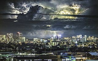
A black nor'easter is a persistent and potentially violent north-easterly storm that occurs on the east coast of Australia, particularly from southeastern Queensland to southern New South Wales, usually between late spring and early autumn, about two days a year.

The Australian Northwest Cloudband (NWCB), or just Northwest cloudband, is a band of a broad, continuous, moisture-laden cloud that stretches from the tropical east Indian Ocean to southern Australia, which would form in the cool season and may generally bring sporadic precipitation across the Australian continent. The NWCB is the third most commonly occurring cloudband in the world and the fourth most frequently occurring cloudband in the Southern Hemisphere.

The southeast Australian foehn is a westerly foehn wind and a rain shadow effect that usually occurs on the coastal plain of southern New South Wales, and as well as in southeastern Victoria and eastern Tasmania, on the leeward side of the Great Dividing Range. Ranging from cool to hot, the effect occurs when westerly winds descend steeply from the Great Dividing Range onto the coastal slopes, whereby causing major adiabatic compression and a substantial loss of moisture.
2022 was an extremely wet year for Australia, coming out of a back-to-back La Niña in the summer of 2021-22, a Negative Indian Ocean Dipole developing over the winter and a third back-to-back La Niña in the spring of 2022.


