The 1998 Pacific hurricane season was a fairly average Pacific hurricane season. Despite this, it had nine hurricanes and six major hurricanes, which was well above average. The season officially started on May 15 in the eastern Pacific and on June 1 in the central Pacific, and ended on November 30; these dates conventionally delimit the period during which most tropical cyclones form in that region. The first tropical cyclone developed on June 11, about ten days later than the normal start of the season. The final storm of the year, Hurricane Madeline, dissipated on October 20. Storm activity in the Central Pacific Hurricane Center's warning zone was low, with just one tropical depression observed in the region. Two tropical cyclones from the eastern Pacific also entered the central Pacific; the former did so as a hurricane.

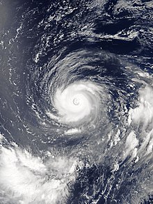
A rainband is a cloud and precipitation structure associated with an area of rainfall which is significantly elongated. Rainbands can be stratiform or convective, and are generated by differences in temperature. When noted on weather radar imagery, this precipitation elongation is referred to as banded structure. Rainbands within tropical cyclones are curved in orientation. Rainbands of tropical cyclones contain showers and thunderstorms that, together with the eyewall and the eye, constitute a hurricane or tropical storm. The extent of rainbands around a tropical cyclone can help determine the cyclone's intensity.

Rapid intensification (RI) is any process wherein a tropical cyclone strengthens dramatically in a short period of time. Tropical cyclone forecasting agencies utilize differing thresholds for designating rapid intensification events, though the most widely-used definition stipulates an increase in the maximum sustained winds of a tropical cyclone of at least 30 knots in a 24-hour period. However, periods of rapid intensification often last longer than a day. About 20–30% of all tropical cyclones undergo rapid intensification, including a majority of tropical cyclones with peak wind speeds exceeding 51 m/s.

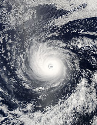
The eye is a region of mostly calm weather at the center of a tropical cyclone. The eye of a storm is a roughly circular area, typically 30–65 kilometers in diameter. It is surrounded by the eyewall, a ring of towering thunderstorms where the most severe weather and highest winds of the cyclone occur. The cyclone's lowest barometric pressure occurs in the eye and can be as much as 15 percent lower than the pressure outside the storm.

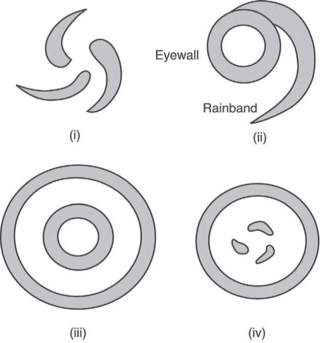
The Dvorak technique is a widely used system to estimate tropical cyclone intensity based solely on visible and infrared satellite images. Within the Dvorak satellite strength estimate for tropical cyclones, there are several visual patterns that a cyclone may take on which define the upper and lower bounds on its intensity. The primary patterns used are curved band pattern (T1.0-T4.5), shear pattern (T1.5–T3.5), central dense overcast (CDO) pattern (T2.5–T5.0), central cold cover (CCC) pattern, banding eye pattern (T4.0–T4.5), and eye pattern (T4.5–T8.0).

The central dense overcast, or CDO, of a tropical cyclone or strong subtropical cyclone is the large central area of thunderstorms surrounding its circulation center, caused by the formation of its eyewall. It can be round, angular, oval, or irregular in shape. This feature shows up in tropical cyclones of tropical storm or hurricane strength. How far the center is embedded within the CDO, and the temperature difference between the cloud tops within the CDO and the cyclone's eye, can help determine a tropical cyclone's intensity with the Dvorak technique. Locating the center within the CDO can be a problem with strong tropical storms and minimal hurricanes as its location can be obscured by the CDO's high cloud canopy. This center location problem can be resolved through the use of microwave satellite imagery.

A tropical cyclone is a rapidly rotating storm system characterized by a low-pressure center, a closed low-level atmospheric circulation, strong winds, and a spiral arrangement of thunderstorms that produce heavy rain and squalls. Depending on its location and strength, a tropical cyclone is referred to by different names, including hurricane, typhoon, tropical storm, cyclonic storm, tropical depression, or simply cyclone. A hurricane is a strong tropical cyclone that occurs in the Atlantic Ocean or northeastern Pacific Ocean, and a typhoon occurs in the northwestern Pacific Ocean. In the Indian Ocean and South Pacific, comparable storms are referred to as "tropical cyclones", and such storms in the Indian Ocean can also be called "severe cyclonic storms".

Hurricane Wilma was the most intense tropical cyclone in the Atlantic basin on record in terms of minimum barometric pressure, with an atmospheric pressure of 882 millibars (26.0 inHg). Wilma's destructive journey began in the second week of October 2005. A large area of disturbed weather developed across much of the Caribbean and gradually organized to the southeast of Jamaica. By late on October 15, the system was sufficiently organized for the National Hurricane Center to designate it as Tropical Depression Twenty-Four.
Hurricane Daniel was the second strongest hurricane of the 2006 Pacific hurricane season. The storm affected Hawaii late in its lifetime, causing moderate rainfall and minor damage. The fourth named storm, third hurricane, and second major hurricane of the season, Daniel originated on July 16 from a tropical wave off the coast of Mexico. It tracked westward, intensifying steadily to reach peak winds of 150 mph (240 km/h) on July 22. At the time, the characteristics of the cyclone resembled those of an annular hurricane. Daniel gradually weakened as it entered an area of cooler water temperatures and increased wind shear, and after crossing into the Central Pacific Ocean, it quickly degenerated into a remnant low on July 26, before dissipating two days later.
A mesovortex is a small-scale rotational feature found in a convective storm, such as a quasi-linear convective system, a supercell, or the eyewall of a tropical cyclone. Mesovortices range in diameter from tens of miles to a mile or less and can be immensely intense.

In meteorology, eyewall replacement cycles, also called concentric eyewall cycles, naturally occur in intense tropical cyclones, generally with winds greater than 185 km/h (115 mph), or major hurricanes. When tropical cyclones reach this intensity, and the eyewall contracts or is already small, some of the outer rainbands may strengthen and organize into a ring of thunderstorms—a new, outer eyewall—that slowly moves inward and robs the original, inner eyewall of its needed moisture and angular momentum. Since the strongest winds are in a tropical cyclone's eyewall, the storm usually weakens during this phase, as the inner wall is "choked" by the outer wall. Eventually the outer eyewall replaces the inner one completely, and the storm may re-intensify.

Hurricane Epsilon was the twenty-seventh named tropical or subtropical storm and the final of 15 hurricanes in the record-breaking 2005 Atlantic hurricane season. Originating from a cold front beneath an upper-level low, Epsilon formed on November 29 about 915 mi (1470 km) east of Bermuda, becoming the second tropical storm to do so in that area of the Atlantic within the span of a week. Initially, the National Hurricane Center (NHC) forecast the storm to transition into an extratropical cyclone within five days, due to conditions unfavorable for significant intensification. Epsilon continually defied forecasts, at first due to an unexpected loop to the southwest, and later due to retaining its strength despite cold waters and strong wind shear.

Severe Tropical Cyclone Jasmine was a powerful and long-lived annular tropical cyclone that affected several countries, particularly Vanuatu and Tonga, over a 16-day span in February 2012. The system was the second cyclone and the only severe tropical cyclone of the relatively quiet 2011–12 South Pacific cyclone season. Cyclone Jasmine developed from an area of disturbed weather on 1 February in the Gulf of Carpentaria. Initially, the storm moved towards the east and across the Cape York Peninsula. As it moved across the South Pacific, earlier existing wind shear conditions lessened, and Jasmine began to strengthen at a faster rate. Steadily intensifying, Jasmine reached peak intensity on 8 February as a Category 4 equivalent on the Saffir–Simpson Hurricane Scale, while beginning to show annular characteristics.

The following is a glossary of tropical cyclone terms.

Hurricane Dora was the strongest tropical cyclone in the northeastern Pacific in 2011 that brought minor impacts to Mexico and the US in July of that year. The fourth named storm, fourth hurricane, and second major hurricane of the year, Dora developed from a tropical wave south of Honduras on July 18. Moving northwestward in favorable conditions, the system quickly intensified to tropical storm status and attained hurricane intensity the next day. Rapid intensification ensued shortly thereafter, bringing the storm to its peak intensity on July 21 as a Category 4 hurricane, with a minimum barometric pressure of 929 mbar and maximum sustained winds of 155 mph (250 km/h). However, the storm's path into an area with cool sea surface temperatures and wind shear caused Dora to quickly deteriorate and weaken. By July 24, Dora had degenerated into a remnant low-pressure area west of the Baja California Peninsula.

Hurricane Patricia was the most intense tropical cyclone ever recorded in the Western Hemisphere and the second-most intense worldwide in terms of barometric pressure. It also featured the highest one-minute maximum sustained winds ever recorded in a tropical cyclone. Originating from a sprawling disturbance near the Gulf of Tehuantepec in mid-October 2015, Patricia was first classified a tropical depression on October 20. Initial development was slow, with only modest strengthening within the first day of its classification. The system later became a tropical storm and was named Patricia, the twenty-fourth named storm of the annual hurricane season. Exceptionally favorable environmental conditions fueled explosive intensification on October 22. A well-defined eye developed within an intense central dense overcast and Patricia grew from a tropical storm to a Category 5 hurricane in just 24 hours—a near-record pace. The magnitude of intensification was poorly forecast and both forecast models and meteorologists suffered from record-high prediction errors.
The Hurricane Rainband and Intensity Change Experiment (RAINEX) is a project to improve hurricane intensity forecasting via measuring interactions between rainbands and the eyewalls of tropical cyclones. The experiment was planned for the 2005 Atlantic hurricane season. This coincidence of RAINEX with the 2005 Atlantic hurricane season led to the study and exploration of infamous hurricanes Katrina, Ophelia, and Rita. Where Hurricane Katrina and Hurricane Rita would go on to cause major damage to the US Gulf coast, Hurricane Ophelia provided an interesting contrast to these powerful cyclones as it never developed greater than a Category 1.

Hurricane Hector was a powerful and long-lasting tropical cyclone that traversed the Pacific Ocean during late July and August 2018. Hector was the eighth named storm, fourth hurricane, and third major hurricane of the 2018 Pacific hurricane season. It originated from a disturbance that was located north of South America on July 22. The disturbance tracked westward and entered the eastern Pacific around July 25. It gradually organized over the next several days, becoming a tropical depression at 12:00 UTC on July 31. The system was upgraded into a tropical storm about 12 hours later and received the name Hector. Throughout most of its existence, the cyclone traveled due west or slightly north of west. A favorable environment allowed the fledgling tropical storm to rapidly intensify to its initial peak as a Category 2 hurricane by 18:00 UTC on August 2. Wind shear caused Hector to weaken for a brief period before the storm began to strengthen again. Hector reached Category 3 status by 00:00 UTC on August 4 and went through an eyewall replacement cycle soon after, which caused the intensification to halt. After the replacement cycle, the cyclone continued to organize, developing a well-defined eye surrounded by cold cloud tops.

The meteorological history of Hurricane Florence spanned 22 days from its inception on August 28, 2018, to its dissipation on September 18. Originating from a tropical wave over West Africa, Florence quickly organized upon its emergence over the Atlantic Ocean. Favorable atmospheric conditions enabled it to develop into a tropical depression on August 31 just south of the Cape Verde islands. Intensifying to a tropical storm the following day, Florence embarked on a west-northwest to northwest trajectory over open ocean. Initially being inhibited by increased wind shear and dry air, the small cyclone took advantage of a small area of low shear and warm waters. After achieving hurricane strength early on September 4, Florence underwent an unexpected period of rapid deepening through September 5, culminating with it becoming a Category 4 hurricane on the Saffir-Simpson scale. Thereafter, conditions again became unfavorable and the hurricane quickly diminished to a tropical storm on September 7.

Hurricane Katrina was a devastating tropical cyclone that had a long and complex meteorological history, spanning a month from August 8 to September 7, 2005. Katrina's origins can be traced to the mid-level remnants of Tropical Depression Ten, a tropical wave, and an upper tropospheric trough. The tropical depression emerged as a wave off West Africa on August 8, the second wave followed on August 11, while the trough factored into tropical cyclogenesis between August 17 and 23. The mid-level remnants of Tropical Depression Ten merged with the second tropical wave on August 19 while located north of Hispaniola. Subsequent interaction with the trough spurred convective development, resulting in the formation of Tropical Depression Twelve over the Bahamas on August 23. Deep convection soon blossomed and following the development of banding features the system intensified into a tropical storm. As it strengthened into a hurricane, Katrina made its first landfall in the Miami Metropolitan Area on August 25.