Satellite images (also Earth observation imagery, spaceborne photography, or simply satellite photo) are images of Earth collected by imaging satellites operated by governments and businesses around the world. Satellite imaging companies sell images by licensing them to governments and businesses such as Apple Maps and Google Maps.
The first images from space were taken on sub-orbital flights. The U.S-launched V-2 flight on October 24, 1946, took one image every 1.5 seconds. With an apogee of 65 miles (105 km), these photos were from five times higher than the previous record, the 13.7 miles (22 km) by the Explorer II balloon mission in 1935. [1] The first satellite (orbital) photographs of Earth were made on August 14, 1959, by the U.S. Explorer 6. [2] [3] The first satellite photographs of the Moon might have been made on October 6, 1959, by the Soviet satellite Luna 3, on a mission to photograph the far side of the Moon. The Blue Marble photograph was taken from space in 1972, and has become very popular in the media and among the public. Also in 1972 the United States started the Landsat program, the largest program for acquisition of imagery of Earth from space. In 1977, the first real time satellite imagery was acquired by the United States's KH-11 satellite system. The most recent Landsat satellite, Landsat 9, was launched on 27 September 2021. [4]
All satellite images produced by NASA are published by NASA Earth Observatory and are freely available to the public. Several other countries have satellite imaging programs, and a collaborative European effort launched the ERS and Envisat satellites carrying various sensors. There are also private companies that provide commercial satellite imagery. In the early 21st century satellite imagery became widely available when affordable, easy to use software with access to satellite imagery databases was offered by several companies and organizations.
Satellite images have many applications in meteorology, oceanography, fishing, agriculture, biodiversity conservation, forestry, landscape, geology, cartography, regional planning, education, intelligence and warfare. Less mainstream uses include anomaly hunting, a criticized investigation technique involving the search of satellite images for unexplained phenomena. [5] Images can be in visible colors and in other spectra. There are also elevation maps, usually made by radar images. Image interpretation and analysis of satellite imagery is conducted using specialized remote sensing software.
This section duplicates the scope of other articles, specifically Remote sensing#Data characteristics.(February 2019) |
There are five types of resolution when discussing satellite imagery in remote sensing: spatial, spectral, temporal, radiometric and geometric. Campbell (2002) [6] defines these as follows:
The resolution of satellite images varies depending on the instrument used and the altitude of the satellite's orbit. For example, the Landsat archive offers repeated imagery at 30 meter resolution for the planet, but most of it has not been processed from the raw data. Landsat 7 has an average return period of 16 days. For many smaller areas, images with resolution as fine as 41 cm can be available. [7]
Satellite imagery is sometimes supplemented with aerial photography, which has higher resolution, but is more expensive per square meter. Satellite imagery can be combined with vector or raster data in a GIS provided that the imagery has been spatially rectified so that it will properly align with other data sets.
Satellite imaging of the Earth surface is of sufficient public utility that many countries maintain satellite imaging programs. The United States has led the way in making these data freely available for scientific use. Some of the more popular programs are listed below, recently followed by the European Union's Sentinel constellation.
The CORONA program was a series of American strategic reconnaissance satellites produced and operated by the Central Intelligence Agency (CIA) Directorate of Science & Technology with substantial assistance from the U.S. Air Force. The type of imagery is wet film panoramic and it used two cameras (AFT&FWD) for capturing stereographic imagery.
Landsat is the oldest continuous Earth-observing satellite imaging program. Optical Landsat imagery has been collected at 30 m resolution since the early 1980s. Beginning with Landsat 5, thermal infrared imagery was also collected (at coarser spatial resolution than the optical data). The Landsat 7, Landsat 8, and Landsat 9 satellites are currently in orbit.
MODIS has collected near-daily satellite imagery of the earth in 36 spectral bands since 2000. MODIS is on board the NASA Terra and Aqua satellites.
The ESA is currently developing the Sentinel constellation of satellites. Currently, 7 missions are planned, each for a different application. Sentinel-1 (SAR imaging), Sentinel-2 (decameter optical imaging for land surfaces), and Sentinel-3 (hectometer optical and thermal imaging for land and water) have already been launched.
The ASTER is an imaging instrument onboard Terra, the flagship satellite of NASA's Earth Observing System (EOS) launched in December 1999. ASTER is a cooperative effort between NASA, Japan's Ministry of Economy, Trade and Industry (METI), and Japan Space Systems (J-spacesystems). ASTER data is used to create detailed maps of land surface temperature, reflectance, and elevation. The coordinated system of EOS satellites, including Terra, is a major component of NASA's Science Mission Directorate and the Earth Science Division. The goal of NASA Earth Science is to develop a scientific understanding of the Earth as an integrated system, its response to change, and to better predict variability and trends in climate, weather, and natural hazards. [8]
The Meteosat -2 geostationary weather satellite began operationally to supply imagery data on 16 August 1981. Eumetsat has operated the Meteosats since 1987.
Several satellites are built and maintained by private companies, as follows.
GeoEye's GeoEye-1 satellite was launched on September 6, 2008. [9] The GeoEye-1 satellite has high resolution imaging system and is able to collect images with a ground resolution of 0.41 meters (16 inches) in panchromatic or black and white mode. It collects multispectral or color imagery at 1.65-meter resolution or about 64 inches.
Maxar's WorldView-2 satellite provides high resolution commercial satellite imagery with 0.46 m spatial resolution (panchromatic only). [10] The 0.46 meters resolution of WorldView-2's panchromatic images allows the satellite to distinguish between objects on the ground that are at least 46 cm apart. Similarly Maxar's QuickBird satellite provides 0.6 meter resolution (at nadir) panchromatic images.
Maxar's WorldView-3 satellite provides high resolution commercial satellite imagery with 0.31 m spatial resolution. WVIII also carries a short wave infrared sensor and an atmospheric sensor [11]
Pléiades constellation is composed of two very-high-resolution (50 centimeters pan & 2.1 meter spectral) optical Earth-imaging satellites. Pléiades-HR 1A and Pléiades-HR 1B provide the coverage of Earth's surface with a repeat cycle of 26 days. Designed as a dual civil/military system, Pléiades will meet the space imagery requirements of European defence as well as civil and commercial needs. Pléiades Neo [12] is the advanced optical constellation, with four identical 30-cm resolution satellites with fast reactivity.
The 3 SPOT satellites in orbit (Spot 5, 6, 7) provide very high resolution images – 1.5 m for Panchromatic channel, 6m for Multi-spectral (R,G,B,NIR). Spot Image also distributes multiresolution data from other optical satellites, in particular from Formosat-2 (Taiwan) and Kompsat-2 (South Korea) and from radar satellites (TerraSar-X, ERS, Envisat, Radarsat). Spot Image is also the exclusive distributor of data from the high resolution Pleiades satellites with a resolution of 0.50 meter or about 20 inches. The launches occurred in 2011 and 2012, respectively. The company also offers infrastructures for receiving and processing, as well as added value options.
In 2015, Planet acquired BlackBridge, and its constellation of five RapidEye satellites, launched in August 2008. [13] The RapidEye constellation contains identical multispectral sensors which are equally calibrated. Therefore, an image from one satellite will be equivalent to an image from any of the other four, allowing for a large amount of imagery to be collected (4 million km2 per day), and daily revisit to an area. Each travel on the same orbital plane at 630 km, and deliver images in 5 meter pixel size. RapidEye satellite imagery is especially suited for agricultural, environmental, cartographic and disaster management applications. The company not only offers their imagery, but consults their customers to create services and solutions based on analysis of this imagery. The RapidEye constellation was retired by Planet in April 2020.
Earth Resource Observation Satellites, better known as "EROS" satellites, are lightweight, low earth orbiting, high-resolution satellites designed for fast maneuvering between imaging targets. In the commercial high-resolution satellite market, EROS is the smallest very high resolution satellite; it is very agile and thus enables very high performances. The satellites are deployed in a circular Sun-synchronous near polar orbit at an altitude of 510 km (± 40 km). EROS satellites imagery applications are primarily for intelligence, homeland security and national development purposes but also employed in a wide range of civilian applications, including: mapping, border control, infrastructure planning, agricultural monitoring, environmental monitoring, disaster response, training and simulations, etc.
EROS A – a high resolution satellite with 1.9–1.2m resolution panchromatic was launched on December 5, 2000.
EROS B – the second generation of Very High Resolution satellites with 70 cm resolution panchromatic, was launched on April 25, 2006.
EROS C2 - the third generation of Very High Resolution satellites with 30cm. resolution panchromatic, was launched in 2021.
EROS C3 - the third generation of Very High Resolution satellites with 30cm. resolution panchromatic and multispectral, was launched in 2023.
GaoJing-1 / SuperView-1 (01, 02, 03, 04) is a commercial constellation of Chinese remote sensing satellites controlled by China Siwei Surveying and Mapping Technology Co. Ltd. The four satellites operate from an altitude of 530 km and are phased 90° from each other on the same orbit, providing 0.5m panchromatic resolution and 2m multispectral resolution on a swath of 12 km. [14] [15]
Because the total area of the land on Earth is so large and because resolution is relatively high, satellite databases are huge and image processing (creating useful images from the raw data) is time-consuming.[ citation needed ] Preprocessing, such as image destriping, is often required. Depending on the sensor used, weather conditions can affect image quality: for example, it is difficult to obtain images for areas of frequent cloud cover such as mountaintops. For such reasons, publicly available satellite image datasets are typically processed for visual or scientific commercial use by third parties.
Commercial satellite companies do not place their imagery into the public domain and do not sell their imagery; instead, one must acquire a license to use their imagery. Thus, the ability to legally make derivative works from commercial satellite imagery is diminished.
Privacy concerns have been brought up by some who wish not to have their property shown from above. Google Maps responds to such concerns in their FAQ with the following statement: "We understand your privacy concerns... The images that Google Maps displays are no different from what can be seen by anyone who flies over or drives by a specific geographic location." [16]
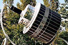
Envisat is a large Earth-observing satellite which has been inactive since 2012. It is still in orbit and considered space debris. Operated by the European Space Agency (ESA), it was the world's largest civilian Earth observation satellite.
A weather satellite or meteorological satellite is a type of Earth observation satellite that is primarily used to monitor the weather and climate of the Earth. Satellites can be polar orbiting, or geostationary.
The Landsat program is the longest-running enterprise for acquisition of satellite imagery of Earth. It is a joint NASA / USGS program. On 23 July 1972, the Earth Resources Technology Satellite was launched. This was eventually renamed to Landsat 1 in 1975. The most recent, Landsat 9, was launched on 27 September 2021.
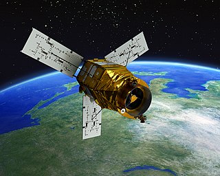
Landsat 7 is the seventh satellite of the Landsat program. Launched on 15 April 1999, Landsat 7's primary goal is to refresh the global archive of satellite photos, providing up-to-date and cloud-free images. The Landsat program is managed and operated by the United States Geological Survey, and data from Landsat 7 is collected and distributed by the USGS. The NASA WorldWind project allows 3D images from Landsat 7 and other sources to be freely navigated and viewed from any angle. The satellite's companion, Earth Observing-1, trailed by one minute and followed the same orbital characteristics, but in 2011 its fuel was depleted and EO-1's orbit began to degrade. Landsat 7 was built by Lockheed Martin Space Systems.
SPOT is a commercial high-resolution optical Earth imaging satellite system operating from space. It is run by Spot Image, based in Toulouse, France. It was initiated by the CNES in the 1970s and was developed in association with the SSTC and the Swedish National Space Board (SNSB). It has been designed to improve the knowledge and management of the Earth by exploring the Earth's resources, detecting and forecasting phenomena involving climatology and oceanography, and monitoring human activities and natural phenomena. The SPOT system includes a series of satellites and ground control resources for satellite control and programming, image production, and distribution. Earlier satellites were launched using the European Space Agency's Ariane 2, 3, and 4 rockets, while SPOT 6 and SPOT 7 were launched by the Indian PSLV.
DigitalGlobe was an American commercial vendor of space imagery and geospatial content, and operator of civilian remote sensing spacecraft. The company went public on the New York Stock Exchange on 14 May 2009, selling 14.7 million shares at US$19.00 each to raise US$279 million in capital. On 5 October 2017, Maxar Technologies completed its acquisition of DigitalGlobe.
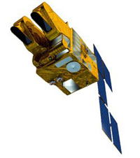
IKONOS was a commercial Earth observation satellite, and was the first to collect publicly available high-resolution imagery at 1- and 4-meter resolution. It collected multispectral (MS) and panchromatic (PAN) imagery. The capability to observe Earth via space-based telescope has been called "one of the most significant developments in the history of the space age", and IKONOS brought imagery rivaling that of military spy satellites to the commercial market. IKONOS imagery began being sold on 1 January 2000, and the spacecraft was retired in 2015.
Landsat 4 is the fourth satellite of the Landsat program. It was launched on July 16, 1982, with the primary goal of providing a global archive of satellite imagery. Although the Landsat Program is managed by NASA, data from Landsat 4 was collected and distributed by the U.S. Geological Survey. Landsat 4 science operations ended on December 14, 1993, when the satellite lost its ability to transmit science data, far beyond its designed life expectancy of five years. The satellite housekeeping telemetry and tracking continued to be maintained by NASA until it was decommissioned on June 15, 2001.
Landsat 3 is the third satellite of the Landsat program. It was launched on March 5, 1978, with the primary goal of providing a global archive of satellite imagery. Unlike later Landsat satellites, Landsat 3 was managed solely by NASA. Landsat 3 decommissioned on September 7, 1983, beyond its design life of one year. The data collected during Landsat 3's lifetime was used by 31 countries. Countries that cannot afford their own satellite are able to use the data for ecological preservation efforts and to determine the location of natural resources.
QuickBird was a high-resolution commercial Earth observation satellite, owned by DigitalGlobe, launched in 2001 and reentered after orbit decay in 2015. QuickBird used Ball Aerospace's Global Imaging System 2000. The satellite collected panchromatic imagery at 61 centimeter resolution and multispectral imagery at 2.44- to 1.63-meter resolution, as orbit altitude is lowered during the end of mission life.
Copernicus is the Earth observation component of the European Union Space Programme, managed by the European Commission and implemented in partnership with the EU Member States, the European Space Agency (ESA), the European Organisation for the Exploitation of Meteorological Satellites (EUMETSAT), the European Centre for Medium-Range Weather Forecasts (ECMWF), the Joint Research Centre (JRC), the European Environment Agency (EEA), the European Maritime Safety Agency (EMSA), Frontex, SatCen and Mercator Océan.
Landsat 2 is the second satellite of the Landsat program. The spacecraft originally carried a designation of ERTS-B but was renamed "Landsat 2" prior to its launch on January 22, 1975. The objective of the satellite was to acquire global, seasonal data in medium resolution from a near-polar, Sun-synchronous orbit. The satellite, built by General Electric, acquired data with the Return Beam Vidicon (RBV) and the Multispectral Scanner (MSS). Despite having a design life of one year, Landsat 2 operated for over seven years, finally ceasing operations on February 25, 1982.
GeoEye Inc. was an American commercial satellite imagery company based in Herndon, Virginia. GeoEye was merged into the DigitalGlobe corporation on January 29, 2013.
Landsat 8 is an American Earth observation satellite launched on 11 February 2013. It is the eighth satellite in the Landsat program; the seventh to reach orbit successfully. Originally called the Landsat Data Continuity Mission (LDCM), it is a collaboration between NASA and the United States Geological Survey (USGS). NASA Goddard Space Flight Center in Greenbelt, Maryland, provided development, mission systems engineering, and acquisition of the launch vehicle while the USGS provided for development of the ground systems and will conduct on-going mission operations. It comprises the camera of the Operational Land Imager (OLI) and the Thermal Infrared Sensor (TIRS), which can be used to study Earth surface temperature and is used to study global warming.
KOMPSAT-3, also known as Arirang-3, is a South Korean multipurpose Earth observation satellite. It was launched from Tanegashima Space Center, Japan at 16:39 UTC on 17 May 2012. Like the earlier KOMPSAT-1 and KOMPSAT-2 satellites, it takes its name from the popular Korean folk song Arirang. Its launch was the culmination of a project begun in 1995.
The Mohammed bin Rashid Space Centre is a Dubai government organisation working on the UAE space programme, which includes various space satellite projects, the Emirates Mars Mission, the Emirates Lunar Mission, and the UAE astronaut programme. The centre actively works to promote space science and research in the region. The centre encompasses the Emirates Institution for Advanced Science and Technology (EIAST).
Planet Labs PBC is a publicly trading American Earth imaging company based in San Francisco, California. Their goal is to image the entirety of the Earth daily to monitor changes and pinpoint trends.
Landsat 9 is an Earth observation satellite launched on 27 September 2021 from Space Launch Complex-3E at Vandenberg Space Force Base on an Atlas V 401 launch vehicle. NASA is in charge of building, launching, and testing the satellite, while the United States Geological Survey (USGS) operates the satellite, and manages and distributes the data archive. It is the ninth satellite in the Landsat program, but Landsat 6 failed to reach orbit. The Critical Design Review (CDR) was completed by NASA in April 2018, and Northrop Grumman Innovation Systems (NGIS) was given the go-ahead to manufacture the satellite.
The International Charter "Space and Major Disasters" is a non-binding charter which provides for the charitable and humanitarian acquisition and transmission of satellite data to relief organizations in the event of major disasters. Initiated by the European Space Agency and the French space agency CNES after the UNISPACE III conference held in Vienna, Austria, in July 1999, it officially came into operation on November 1, 2000, after the Canadian Space Agency signed onto the charter on October 20, 2000. Their space assets were then, respectively, ERS and ENVISAT, SPOT and Formosat, and RADARSAT.
EOS SAT-1 is an optical Earth observation satellite for agricultural land monitoring by EOS Data Analytics, Inc., a global AI-powered satellite imagery analytics provider. The space optics instrument and satellite manufacturer Dragonfly Aerospace built the satellite and equipped it with two high-resolution DragonEye cameras.