Cardinal direction

Last updated

A compass rose showing the four cardinal directions, the four intercardinal directions, and eight more divisions. Brosen windrose.svg
A compass rose showing the four cardinal directions, the four intercardinal directions, and eight more divisions.

The four cardinal directions, or cardinal points, are the four main compass directions: north, south, east, and west, commonly denoted by their initials N, S, E, and W respectively. Relative to north, the directions east, south, and west are at 90 degree intervals in the clockwise direction.

Contents

The ordinal directions (also called the intercardinal directions) are northeast (NE), southeast (SE), southwest (SW), and northwest (NW). The intermediate direction of every set of intercardinal and cardinal direction is called a secondary intercardinal direction. These eight shortest points in the compass rose shown to the right are:

  1. West-northwest (WNW)
  2. North-northwest (NNW)
  3. North-northeast (NNE)
  4. East-northeast (ENE)
  5. East-southeast (ESE)
  6. South-southeast (SSE)
  7. South-southwest (SSW)
  8. West-southwest (WSW)

Points between the cardinal directions form the points of the compass. Arbitrary horizontal directions may be indicated by their azimuth angle value.

Determination

Direction determination refers to the ways in which a cardinal direction or compass point can be determined in navigation and wayfinding. The most direct method is using a compass (magnetic compass or gyrocompass), but indirect methods exist, based on the Sun path (unaided or by using a watch or sundial), the stars, and satellite navigation. [1]

Additional points

Azimuth

The directional names are routinely associated with azimuths, the angle of rotation (in degrees) in the unit circle over the horizontal plane. It is a necessary step for navigational calculations (derived from trigonometry) and for use with Global Positioning System (GPS) receivers. The four cardinal directions correspond to the following degrees of a compass:

Intercardinal directions

The intercardinal (intermediate, or, historically, ordinal [2] ) directions are the four intermediate compass directions located halfway between each pair of cardinal directions.

These eight directional names have been further compounded known as tertiary intercardinal directions, resulting in a total of 32 named points evenly spaced around the compass: north (N), north by east (NbE), north-northeast (NNE), northeast by north (NEbN), northeast (NE), northeast by east (NEbE), east-northeast (ENE), east by north (EbN), east (E), etc.

Beyond geography

Cardinal directions or cardinal points may sometimes be extended to include vertical position (elevation, altitude, depth): north and south, east and west, up and down; or mathematically the six directions of the x-, y-, and z-axes in three-dimensional Cartesian coordinates. Topographic maps include elevation, typically via contour lines. Alternatively, elevation angle may be combined with cardinal direction (or, more generally, arbitrary azimuth angle) to form a local spherical coordinate system.

In astronomy

In astronomy, the cardinal points of an astronomical body as seen in the sky are four points defined by the directions toward which the celestial poles lie relative to the center of the disk of the object in the sky. [3] [4] A line (a great circle on the celestial sphere) from the center of the disk to the North celestial pole will intersect the edge of the body (the "limb") at the North point. The North point will then be the point on the limb that is closest to the North celestial pole. Similarly, a line from the center to the South celestial pole will define the South point by its intersection with the limb. The points at right angles to the North and South points are the East and West points. Going around the disk clockwise from the North point, one encounters in order the West point, the South point, and then the East point. This is opposite to the order on a terrestrial map because one is looking up instead of down.

Similarly, when describing the location of one astronomical object relative to another, "north" means closer to the North celestial pole, "east" means at a higher right ascension, "south" means closer to the South celestial pole, and "west" means at a lower right ascension. If one is looking at two stars that are below the North Star, for example, the one that is "east" will actually be further to the left.

Germanic origin of names

During the Migration Period, the Germanic names for the cardinal directions entered the Romance languages, where they replaced the Latin names borealis (or septentrionalis) with north, australis (or meridionalis) with south, occidentalis with west and orientalis with east. It is possible that some northern people used the Germanic names for the intermediate directions. Medieval Scandinavian orientation would thus have involved a 45 degree rotation of cardinal directions. [5]

Cultural variations

In many regions of the world, prevalent winds change direction seasonally, and consequently many cultures associate specific named winds with cardinal and intercardinal directions. For example, classical Greek culture characterized these winds as Anemoi.

In pre-modern Europe more generally, between eight and 32 points of the compass – cardinal and intercardinal directions – were given names. These often corresponded to the directional winds of the Mediterranean Sea (for example, southeast was linked to the Sirocco , a wind from the Sahara).

Particular colors are associated in some traditions with the cardinal points. These are typically "natural colors" of human perception rather than optical primary colors.[ vague ]

Many cultures, especially in Asia, include the center as a fifth cardinal point.

Northern Eurasia

Northern EurasiaNESWCSource
Slavic [11]
China [12] [13] [14]
Ainu [15] [16]
Turkic [15]
Kalmyks [17]
Tibet [15]

Central Asian, Eastern European and North East Asian cultures frequently have traditions associating colors with four or five cardinal points.

Systems with five cardinal points (four directions and the center) include those from pre-modern China, as well as traditional Turkic, Tibetan and Ainu cultures. In Chinese tradition, the five cardinal point system is related to I Ching, the Wu Xing and the five naked-eye planets. In traditional Chinese astrology, the zodiacal belt is divided into the four constellation groups corresponding to the directions.

Each direction is often identified with a color, and (at least in China) with a mythological creature of that color. Geographical or ethnic terms may contain the name of the color instead of the name of the corresponding direction. [12] [13]

Examples

East: Green ( "qīng" corresponds to both green and blue); Spring; Wood

Qingdao (Tsingtao): "Green Island", a city on the east coast of China
Green Ukraine

South: Red; Summer; Fire

Red River (Asia): south of China
Red Ruthenia
Red Jews: a semi-mythological group of Jews[ citation needed ]
Red Croatia
Red Sea

West: White; Autumn; Metal

White Sheep Turkmen
Akdeniz, meaning 'White Sea': Mediterranean Sea in Turkish
Balts, Baltic words containing the stem balt- ("white")
Belarus, meaning 'White Russia'
White Ruthenia
White Serbia
White Croatia

North: Black; Winter; Water

Heilongjiang: "Black Dragon River" province in Northeast China, also the Amur River
Kara-Khitan Khanate: "Black Khitans" who originated in Northern China
Karadeniz, literally meaning 'Black Sea': Black Sea in Turkish
Black Hungarians
Black Ruthenia

Center: Yellow; Earth

Huangshan: "Yellow Mountain" in central China
Huang He: "Yellow River" in central China
Golden Horde: "Central Army" of the Mongols

Arabic world

Countries where Arabic is used refer to the cardinal directions as Ash Shamal (N), Al Gharb (W), Ash Sharq (E) and Al Janoob (S). Additionally, Al Wusta is used for the center. All five are used for geographic subdivision names ( wilayahs , states, regions, governorates, provinces, districts or even towns), and some are the origin of some Southern Iberian place names (such as Algarve, Portugal and Axarquía, Spain).

Native Americans

In Mesoamerica and North America, a number of traditional indigenous cosmologies include four cardinal directions and a center. Some may also include "above" and "below" as directions, and therefore focus on a cosmology of seven directions. Among the Hopi of the Southwestern United States, the four named cardinal directions are not North, South, East and West but are the four directions associated with the places of sunrise and sunset at the winter and summer solstices. [18] [19] [20] [21] Each direction may be associated with a color, which can vary widely between nations, but which is usually one of the basic colors found in nature and natural pigments, such as black, red, white, and yellow, with occasional appearances of blue, green, or other hues. [22] There can be great variety in color symbolism, even among cultures that are close neighbors geographically.

India

Ten Hindu deities, known as the "Dikpālas", have been recognized in classical Indian scriptures, symbolizing the four cardinal and four intercardinal directions with the additional directions of up and down. Each of the ten directions has its own name in Sanskrit. [23]

Indigenous Australia

Some indigenous Australians have cardinal directions deeply embedded in their culture. For example, the Warlpiri people have a cultural philosophy deeply connected to the four cardinal directions [24] and the Guugu Yimithirr people use cardinal directions rather than relative direction even when indicating the position of an object close to their body. (For more information, see: Cultures without relative directions.)

The precise direction of the cardinal points appears to be important in Aboriginal stone arrangements.

Many aboriginal languages contain words for the usual four cardinal directions, but some contain words for 5 or even 6 cardinal directions. [25]

Unique (non-compound) names of intercardinal directions

Cardinal and non-compound intercardinal directions in Estonian and Finnish. Notice the intermixed "south" and "southwest". Further intermixing between directions south and northwest occur in other Finnic languages. Ilmakaared+ilmansuunnat.svg
Cardinal and non-compound intercardinal directions in Estonian and Finnish. Notice the intermixed "south" and "southwest". Further intermixing between directions south and northwest occur in other Finnic languages.

In some languages, such as Estonian, Finnish and Breton, the intercardinal directions have names that are not compounds of the names of the cardinal directions (as, for instance, northeast is compounded from north and east). In Estonian, those are kirre (northeast), kagu (southeast), edel (southwest), and loe (northwest), in Finnish koillinen (northeast), kaakko (southeast), lounas (southwest), and luode (northwest). In Japanese, there is the interesting situation that native Japanese words (yamato kotoba, kun readings of kanji) are used for the cardinal directions (such as minami for 南, south), but borrowed Chinese words (on readings of kanji) are used for intercardinal directions (such as tō-nan for 東南, southeast, lit. "east-south").[ dubious ] In the Malay language, adding laut (sea) to either east (timur) or west (barat) results in northeast or northwest, respectively, whereas adding daya to west (giving barat daya) results in southwest. Southeast has a special word: tenggara.

Sanskrit and other Indian languages that borrow from it use the names of the gods associated with each direction: east (Indra), southeast (Agni), south (Yama/Dharma), southwest (Nirrti), west (Varuna), northwest (Vayu), north (Kubera/Heaven) and northeast (Ishana/Shiva). North is associated with the Himalayas and heaven while the south is associated with the underworld or land of the fathers (Pitr loka). The directions are named by adding "disha" to the names of each god or entity: e.g. Indradisha (direction of Indra) or Pitrdisha (direction of the forefathers i.e. south).

The cardinal directions of the Hopi language and the Tewa dialect spoken by the Hopi-Tewa are related to the places of sunrise and sunset at the solstices, and correspond approximately to the European intercardinal directions. [18] [19] [26]

Non-compass directional systems

Use of the compass directions is common and deeply embedded in European and Chinese culture (see south-pointing chariot). Some other cultures make greater use of other referents, such as toward the sea or toward the mountains (Hawaii, Bali), or upstream and downstream (most notably in ancient Egypt, also in the Yurok and Karuk languages). Lengo (Guadalcanal, Solomon Islands) has four non-compass directions: landward, seaward, upcoast, and downcoast.[ citation needed ]

Some languages lack words for body-relative directions such as left/right, and use geographical directions instead. [27]

See also

Related Research Articles

<span class="mw-page-title-main">Compass</span> Instrument used for navigation and orientation

A compass is a device that shows the cardinal directions used for navigation and geographic orientation. It commonly consists of a magnetized needle or other element, such as a compass card or compass rose, which can pivot to align itself with magnetic north. Other methods may be used, including gyroscopes, magnetometers, and GPS receivers.

<span class="mw-page-title-main">Azimuth</span> Horizontal angle from north or other reference cardinal direction

An azimuth is the angular measurement in a spherical coordinate system which represents the horizontal angle from a cardinal direction, most commonly north.

<span class="mw-page-title-main">North</span> One of the four cardinal directions

North is one of the four compass points or cardinal directions. It is the opposite of south and is perpendicular to east and west. North is a noun, adjective, or adverb indicating direction or geography.

<span class="mw-page-title-main">Guardians of the directions</span> Deities of the eight directions in Hinduism and Buddhism

The Guardians of the Directions are the deities who rule the specific directions of space according to Hinduism, Jainism and Vajrayāna Buddhism—especially Kālacakra. As a group of eight deities, they are called Aṣṭa-Dikpāla (अष्ट-दिक्पाल), literally meaning guardians of eight directions. They are often augmented with two extra deities for the ten directions, when they are known as the Daśa-Dikpāla. In Hinduism it is traditional to represent their images on the walls and ceilings of Hindu temples. They are also often portrayed in Jain temples, with the exception that Nāga usually takes the place of Vishnu in the nadir. Ancient Java and Bali Hinduism recognize Nava-Dikpāla, literally meaning guardians of nine directions, that consist of eight directions with one addition in the center. The nine guardian gods of directions is called Dewata Nawa Sanga. The diagram of these guardian gods of directions is featured in Surya Majapahit, the emblem of Majapahit empire.

<span class="mw-page-title-main">Bearing (angle)</span> In navigation, horizontal angle between the direction of an object and another object

In navigation, bearing or azimuth is the horizontal angle between the direction of an object and north or another object. The angle value can be specified in various angular units, such as degrees, mils, or grad. More specifically:

<span class="mw-page-title-main">Qibla</span> Direction that should be faced when a Muslim prays during salah

The qibla is the direction towards the Kaaba in the Sacred Mosque in Mecca, which is used by Muslims in various religious contexts, particularly the direction of prayer for the salah. In Islam, the Kaaba is believed to be a sacred site built by prophets Ibrahim and Ismail, and that its use as the qibla was ordained by Allah in several verses of the Quran revealed to Muhammad in the second Hijri year. Prior to this revelation, Muhammad and his followers in Medina faced Jerusalem for prayers. Most mosques contain a mihrab that indicates the direction of the qibla.

<span class="mw-page-title-main">Compass rose</span> Figure on a compass, map, nautical chart

A compass rose, sometimes called a wind rose, rose of the winds or compass star, is a figure on a compass, map, nautical chart, or monument used to display the orientation of the cardinal directions and their intermediate points. It is also the term for the graduated markings found on the traditional magnetic compass. Today, a form of compass rose is found on, or featured in, almost all navigation systems, including nautical charts, non-directional beacons (NDB), VHF omnidirectional range (VOR) systems, global-positioning systems (GPS), and similar equipment.

<span class="mw-page-title-main">Earthly Branches</span> East Asian system of 12 ordinals

The twelve Earthly Branches or Terrestrial Branches are a Chinese ordering system used throughout East Asia in various contexts, including its ancient dating system, astrological traditions, zodiac and ordinals.

<span class="mw-page-title-main">Points of the compass</span> Directional divisions marked on a compass

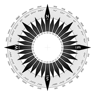
The points of the compass are a set of horizontal, radially arrayed compass directions used in navigation and cartography. A compass rose is primarily composed of four cardinal directions—north, east, south, and west—each separated by 90 degrees, and secondarily divided by four ordinal (intercardinal) directions—northeast, southeast, southwest, and northwest—each located halfway between two cardinal directions. Some disciplines such as meteorology and navigation further divide the compass with additional azimuths. Within European tradition, a fully defined compass has 32 "points".

<span class="mw-page-title-main">Cardinal mark</span> Sea mark indicating where safe water is near to a hazard

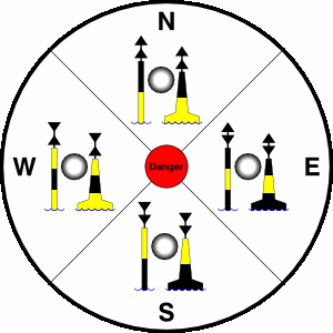
A cardinal mark is a sea mark used in maritime pilotage to indicate the position of a hazard and the direction of safe water.

<span class="mw-page-title-main">Section (United States land surveying)</span> One square mile

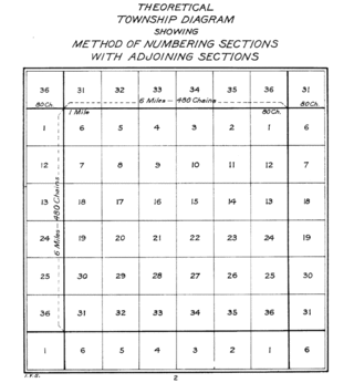
In U.S. land surveying under the Public Land Survey System (PLSS), a section is an area nominally one square mile, containing 640 acres, with 36 sections making up one survey township on a rectangular grid.

True north is the direction along Earth's surface towards the place where the imaginary rotational axis of the Earth intersects the surface of the Earth. That place is called the True North Pole. True south is the direction opposite to the true north. North per se is one of the cardinal directions, a system of naming orientations on the Earth. There are multiple ways of determining the North in different contexts.

<span class="mw-page-title-main">Street system of Denver</span> Dual street grid system in Denver, CO

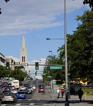
The oldest part of Denver, Colorado, now the neighborhoods of Auraria Campus, LoDo, much of downtown, and Five Points, is laid out on a grid plan that is oriented diagonal to the four cardinal directions. The rest of the city, including the eastern part of downtown, is laid out primarily on a grid oriented to the cardinal directions. In this larger grid, from east to west, there are generally 16 city blocks per mile, except between Zuni Street and Lowell Boulevard in west Denver. From north to south, there are typically eight blocks per mile, although there are many areas with more blocks per mile. Addresses follow a decimal system, with addresses advancing by one hundred at each cross street.

<span class="mw-page-title-main">Pennsylvania Route 819</span> State highway in Pennsylvania, US

Pennsylvania Route 819 is a 46.6-mile-long (75.0 km) state highway located in Fayette and Westmoreland counties in Pennsylvania, United States. The southern terminus is at PA 201 in Vanderbilt. The northern terminus is at PA 66 in Oklahoma.

<span class="mw-page-title-main">Sun path</span> Arc-like path that the Sun appears to follow across the sky

Sun path, sometimes also called day arc, refers to the daily and seasonal arc-like path that the Sun appears to follow across the sky as the Earth rotates and orbits the Sun. The Sun's path affects the length of daytime experienced and amount of daylight received along a certain latitude during a given season.

<span class="mw-page-title-main">Rayleigh sky model</span>

The Rayleigh sky model describes the observed polarization pattern of the daytime sky. Within the atmosphere, Rayleigh scattering of light by air molecules, water, dust, and aerosols causes the sky's light to have a defined polarization pattern. The same elastic scattering processes cause the sky to be blue. The polarization is characterized at each wavelength by its degree of polarization, and orientation.

<span class="mw-page-title-main">Classical compass winds</span> Historical wind directions

In the ancient Mediterranean world, the classical compass winds were names for the points of geographic direction and orientation, in association with the winds as conceived of by the ancient Greeks and Romans. Ancient wind roses typically had twelve winds and thus twelve points of orientation, sometimes reduced to eight or increased to twenty-four.

There are four seas in the world that are named in English after common color names, although most look blue. The names are: The Red Sea, White Sea, Black Sea, and Yellow Sea. Their names are given by the color of the water. Sometimes a system of color symbolism was used as the following method green or light blue for east, black or dark for north, white for west, and red for south. This method is called cardinal directions. There are other theories but these two methods of colors are also used.

Direction determination refers to the ways in which a cardinal direction or compass point can be determined in navigation and wayfinding. The most direct method is using a compass, but indirect methods exist, based on the Sun path, the stars, and satellite navigation.

References

  1. U.S. Army, Advanced Map and Aerial Photograph Reading, Headquarters, War Department, Washington, D.C. (17 September 1941), "DETERMINATION OF DIRECTION BY FIELD EXPEDIENTS"
  2. ""Ordinal directions refer to the direction found at the point equally between each cardinal direction," Cardinal Directions and Ordinal Directions, geolounge.com". 22 July 2013. Archived from the original on 23 February 2019. Retrieved 22 February 2019.
  3. Rigge, W. F (1918). "Partial eclipse of the moon, 1918, June 24". Popular Astronomy. 26: 373. Bibcode:1918PA.....26..373R. rigge1918
  4. Meadows, Peter; meadows. "Solar Observing: Parallactic Angle". Archived from the original on 7 February 2009. Retrieved 15 November 2013.
  5. See e.g. Weibull, Lauritz. De gamle nordbornas väderstrecksbegrepp. Scandia 1/1928; Ekblom, R. Alfred the Great as Geographer. Studia Neophilologica 14/1941-2; Ekblom, R. Den forntida nordiska orientering och Wulfstans resa till Truso. Förnvännen. 33/1938; Sköld, Tryggve. Isländska väderstreck. Scripta Islandica. Isländska sällskapets årsbok 16/1965.
  6. entries 765-66 of the Indogermanisches etymologisches Wörterbuch
  7. entries 86-7 of the Indogermanisches etymologisches Wörterbuch
  8. entries 914-15 of the Indogermanisches etymologisches Wörterbuch
  9. entries 1173 of the Indogermanisches etymologisches Wörterbuch
  10. entries 86-7 of the Indogermanisches etymologisches Wörterbuch
  11. Ukrainian Soviet Encyclopedic dictionary, Kiev, 1987.
  12. 1 2 "Cardinal colors in Chinese tradition". Archived from the original on 21 February 2007. Retrieved 2007-02-17.
  13. 1 2 "Chinese Cosmogony". Archived from the original on 18 December 2010. Retrieved 17 February 2007.
  14. Helmut Nickel (2004). "Black against white: What color was King Arthur's horse?". Arthuriana. pp. 69–72. Nickel also claims that at the 201 BC battle of Baideng, Mo-tun's cavalry were segregated by color: "red (brown) horses formed the vanguard, blacks the rear, whites the right wing, greys (the closest to blue) the left [... and] in the center of the trap the hapless Chinese emperor, whose sacred color was the Imperial yellow." Nickel cites I.P. Potapov (1975). "Uber den Pferdekult bei den turksprachigen Volkern des Sajan-Altai-Gebirges". Abhandlungen und Berichte des Staatlichen Museums fur Volkerkunde Dresden. 34: 486.
  15. 1 2 3 "Colors of the Four Directions". Archived from the original on 13 September 2010. Retrieved 16 May 2010.
  16. Nobuko B. McNeill (July 1982). "Review: 'Two Studies of Color' by Nancy P. Hickerson". International Journal of American Linguistics. 48 (3): 339–342. In Ainu [...] siwnin means both 'yellow' and 'blue' and hu means 'green' and 'red'.
  17. Krupp, E. C.: "Beyond the Blue Horizon: Myths and Legends of the Sun, Moon, Stars, and Planets", page 371. Oxford University Press, 1992
  18. 1 2 Hopi Dictionary Project (University of Arizona Bureau of Applied Research in Anthropology) (1998), Hopi dictionary: Hopìikwa Lavàytutuveni: A Hopi-English dictionary of the Third Mesa dialect with an English-Hopi finder list and a sketch of Hopi grammar , Tucson, Arizona: University of Arizona Press, p. 890, ISBN   978-0-8165-1789-3, The cardinal directions … are "solstitial" in that places on the horizon of sunrise and sunset on the solstices correlate with these directions: On the summer solstice the sun rises in the northeast, hoop, and sets in the northwest, kwiningya; on the winter solstice the sun rises in the southeast, tatkya, and sets in the southwest, taavang.
  19. 1 2 Malotki, Ekkehart (1979), Hopi-Raum: Eine sprachwissenschaftliche Analyse der Raumvorstellungen in der Hopi-Sprache, Tübinger Beiträge zur Linguistik (in German), vol. 81, Tübingen: Gunter Narr Verlag, p. 165, "Die Ausrichtung des Hopi-Kardinalsystems" (The Orientation of the Hopi Cardinal System), ISBN   3-87808-081-6
  20. Curtis, Edward S. (1922), Hodge, Frederick Webb (ed.), The Hopi, The North American Indian, vol. 12, Norwood, Mass.: The Plimpton Press, p. 246, archived from the original on 22 December 2015, retrieved 23 August 2014, Hopi orientation corresponds only approximately with ours, their cardinal points being marked by the solstitial rising and setting points of the sun.... Their cardinal points therefore are not mutually equidistant on the horizon and agree roughly with our semi-cardinal points.
  21. Fewkes, Jesse Walter (1897), "The Group of Tusayan Ceremonials Called Katcinas", Annual Report of the Bureau of Ethnology, vol. 15, Washington, DC: Government Printing Office, p. 258, retrieved 22 August 2022, The names of the four horizon cardinal points are, kwiniwi, northwest; tevyü'ña, southwest; tatyúka, southeast, and hopokyüka (syncopated hópoko), northeast.
  22. Anderson, Kasper Wrem; Helmke, Christophe (2013), "The Personifications of Celestial Water: The Many Guises of the Storm God in the Pantheon and Cosmology of Teotihuacan", Contributions in New World Archaeology, 5: 165–196, at pp. 177–179.{{citation}}: CS1 maint: postscript (link)
  23. H. Rodrigues (22 April 2016). "The Dikpalas". www.mahavidya.ca. Archived from the original on 12 August 2018. Retrieved 12 August 2018.
  24. Ngurra-kurlu: A way of working with Warlpiri people Pawu-Kurlpurlurnu WJ, Holmes M and Box L. 2008, Desert Knowledge CRC Report 41, Alice Springs
  25. Orientations of linear stone arrangements in New South Wales Hamacher et al., 2013, Australian Archaeology, 75, 46–54 Archived 17 June 2013 at the Wayback Machine
  26. Stephen, Alexander M. (1936), Parsons, Elsie Clews (ed.), Hopi Journal of Alexander M. Stephen, Columbia University Contributions to Anthropology, vol. 23, New York: Columbia University Press, pp. 1190–1191, OCLC   716671864
  27. Deutscher, Guy (26 August 2010). "Does Your Language Shape How You Think?". The New York Times . Retrieved 31 August 2010.