
Lincoln Park is a designated community area on the North Side of Chicago, Illinois. Lying to the west of Lincoln Park, Chicago's largest park, it is one of the most affluent neighborhoods in Chicago.

Water Tower Place is a large urban, mixed-use development comprising a 758,000 sq ft (70,400 m2) shopping mall, hotel, theater, and condominiums in a 74-story skyscraper in Chicago, Illinois, United States. The mall is located at 835 North Michigan Avenue, along the Magnificent Mile. It is named after the nearby Chicago Water Tower, and is owned by affiliates of Brookfield Property Partners. As reported by the Chicago Suntimes, Brookfield Property Partners handed the keys to the project back to their lender, MetLife, owing to numerous retail vacancies following the closing of Macy's and the impact of COVID and increasing crime along the once-Magnificent Mile.

State Street is a large south-north street, also one of the main streets, in Chicago, Illinois, USA and its south suburbs. Its intersection with Madison Street has marked the base point for Chicago's address system since 1909. State begins in the north at North Avenue, the south end of Lincoln Park, runs south through the heart of the Chicago Loop, and ends at the southern city limits, intersecting 127th Street along the bank of the Little Calumet River. It resumes north of 137th Street in Riverdale and runs south intermittently through Chicago's south suburbs until terminating at New Monee Road in Crete, Illinois.

The Chicago Pedway is a network of tunnels, ground-level concourses and bridges connecting skyscrapers, retail stores, hotels, and train stations throughout the central business district of Chicago, Illinois.

Division Street is a major east-west street in Chicago, Illinois, located at 1200 North. Division Street begins in the Gold Coast neighborhood near Lake Shore Drive, passes through Polonia Triangle at Milwaukee Avenue into Wicker Park and continues to Chicago's city limits and into the city's western suburbs. Once known as "Polish Broadway" during the heyday of Polish Downtown, Division Street was the favorite street of author Nelson Algren. A fountain dedicated in his name was installed in what had been the area that figured as the inspiration for much of his work.

Western Avenue is a street within the city of Chicago. Western Avenue extends south as a continuous road to the Dixie Highway at Sibley Boulevard in Dixmoor, giving the road a total length of 27.38 miles (44.06 km). Western Avenue, after turning into Asbury Ave, runs out on the north side at Green Bay Road in Evanston and on the south side at Crete-Monee Road in Crete. However, Western Avenue extends intermittently through the Southland to the Will/Kankakee county border in unincorporated Will Township. Within Chicago's grid street system, Western Avenue is 2400 West, three miles west of State Street.
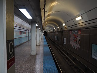
Chicago, is an "L" station on the CTA's Red Line. It serves a significant portion of the Near North Side and Streeterville neighborhoods. With 5,259,992 overall boardings in 2014, it is the busiest station on the Red Line north of the Loop.

108 North State Street, also known as Block 37, is a development located in the Loop community area of downtown Chicago, Illinois. It is located on the square block bounded clockwise from the North by West Randolph Street, North State Street, West Washington Street and North Dearborn Street that is known as "Block 37", which was its designated number as one of the original 58 blocks of the city. Above-ground redevelopment is complete, but work stopped on an underground public transit station when the station were only partially complete.

The Illinois Technology and Research Corridor is a region of commerce and industry located along Interstate 88 in the Chicago metropolitan area, primarily in DuPage, Kane, and DeKalb Counties. The corridor is home to the headquarters or regional centers for many Fortune 1000 companies, several office and industrial parks, colleges and universities, research and scientific institutions, medical centers, government centers, and abundant shopping, dining, lodging, and entertainment amenities. In addition to the I-90 Golden Corridor, the I-94 Lakeshore Corridor, and the I-55 Industrial Corridor, the Illinois Technology and Research Corridor is one of the principal economic centers in suburban Chicago.
The Shops at North Bridge, once known as Westfield North Bridge, is an upscale, urban retail-entertainment district in Chicago, Illinois, located at 520 N. Michigan Avenue. Its anchor store is Nordstrom. Its name alludes first to its location within the nine-block North Bridge complex and to the literal distinction of the shopping center incorporating four-level enclosed bridges over both east Grand Ave, and north Rush Street. When Westfield owned the mall, confusingly, "Westfield North Bridge" typically refers only to the enclosed mall, but Westfield holds a retail management contract for the entire North Bridge complex, which includes another multistory retail complex built in 1995 and street-level retail spaces throughout the complex. North Bridge also includes five hotels, three parking garages, and two office buildings, housing the American Medical Association and Euro RSCG. Upon opening, it also included a DisneyQuest "urban amusement park," since converted into a furniture store.

Clybourn is a railroad station in Chicago serving Metra's Union Pacific North Line and Union Pacific Northwest Line. It is located at 2001 North Ashland Avenue and is the first station north of Ogilvie Transportation Center. Clybourn is located at Clybourn Junction. The Union Pacific North Line's Kenosha Subdivision begins here, separating from the Union Pacific Northwest Line's Harvard Subdivision. Clybourn Junction was named for its location near Clybourn Place, the home of the Clybourn family, early settlers in the Chicago area. Clybourn is situated between the Bucktown and DePaul neighborhoods, several miles north of downtown Chicago. In Metra's zone-based fare schedule, Clybourn is in zone A. As of 2018, Clybourn is the 17th busiest of Metra's 236 non-downtown stations, with an average of 1,674 weekday boardings.

Evanston Main Street is the southernmost of the three commuter railroad stations in Evanston, Illinois. It is served by Metra's Union Pacific North Line trains, which go south to Ogilvie Transportation Center in Chicago and as far north as Kenosha, Wisconsin. Travel time to Ogilvie is typically 23 minutes, but can be as high as 26 minutes during rush hour. In Metra's zone-based fare system, the station is in zone C. As of 2018, Evanston Main Street is the 41st busiest of Metra's 236 non-downtown stations, with an average of 1,130 weekday boardings. The station does not contain a ticket agent booth; passengers must purchase their tickets on board the train.

North/Clybourn is an "L" station on the CTA's Red Line. It is a subway station with two side platforms, located at 1599 North Clybourn Avenue, in the Near North Side neighborhood of Chicago, at the southeastern edge of the commercial Clybourn Corridor. North/Clybourn station is located at the intersection of North Avenue, Halsted Street, and Clybourn Avenue. North/Clybourn was opened on October 17, 1943.

The 4th congressional district of Illinois includes part of Cook County, and has been represented by Democrat Jesús "Chuy" García since January 2019.
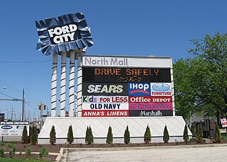
Ford City Mall is a shopping center located on the Southwest Side of Chicago in the West Lawn neighborhood at 76th Street and Cicero Avenue. Opened in 1965, Ford City is the largest enclosed mall in Chicago outside of downtown. Anchored by JCPenney, the mall contains more than 135 stores and restaurants including Applebee’s, Bath & Body Works, The Children’s Place, Foot Locker, Zales Jewelers, Marshalls, Old Navy, Victoria’s Secret/PINK, and Ross Dress for Less. There are several out parcels including a 14-theater AMC Theatres. Ford City Mall is managed by Mid-America Asset Managements.

North Avenue is a major east–west street in Chicago, Illinois, and its western suburbs. Starting at St. Charles's eastern border with West Chicago, its name changes from Main Street to North Avenue, just east of the Kane/DuPage county line. From there, it travels straight east, carrying Illinois Route 64 until LaSalle Drive in Chicago. Illinois Route 64 then continues north onto LaSalle Drive for a very short distance until ending at U.S. Route 41, while North Avenue continues east for less than one-half mile, changing its name to North Boulevard at Clark Street, and then continuing until its termination in a cul-de-sac at 200 East, just west of Lake Shore Drive. From Illinois Route 43 to its east end, North Avenue is within the city limits of Chicago.

North Milwaukee Avenue is a street in the city of Chicago and the northern suburbs.

The Chicago Avenue Pumping Station is a historic district contributing property in the Old Chicago Water Tower District landmark district. It is located on Michigan Avenue along the Magnificent Mile shopping district in the Near North Side community area of Chicago, Illinois. It is on the east side of Michigan Avenue opposite the Chicago Water Tower.

Printers Row, also known as Printing House Row, is a neighborhood located in the south of the Chicago downtown area known as the Loop. The heart of Printers Row is generally defined by Ida B. Wells Drive on the north, Polk Street on the south, Plymouth Court on the east, and the Chicago River on the west. This neighborhood overlaps significantly with the officially designated landmark Printing House Row District to the north of Ida B Wells Drive and the South Loop Printing House District to the south of the Drive. The neighborhood includes Dearborn Station, which is also on the National Register of Historic Places.
1800 N. Clybourn was an enclosed shopping center located at 1800 N. Clybourn Ave. in the Clybourn Corridor area of Lincoln Park, Chicago.