Near North Side, Chicago

Last updated

Near North Side
Community Area 08 - Near North Side
Summer Morning in Chicago (30791823248) (cropped).jpg
Near North Side skyline
Near North Side.png
Streetmap
US-IL-Chicago-CA08.svg
Location within the city of Chicago
Coordinates: 41°54′00″N87°38′04″W / 41.90000°N 87.63444°W / 41.90000; -87.63444 [1]
CountryUnited States
StateIllinois
County Cook
CityChicago
Neighborhoods
Area
  Total2.72 sq mi (7.04 km2)
Elevation
[1]
587 ft (179 m)
Population
 (2020)
  Total105,481
  Density39,000/sq mi (15,000/km2)
 population up 44.9% from 2000
Demographics (2021) [2]
   White 69.4%
  Black6.8%
  Hispanic6.2%
  Asian13.9%
  Other3.7%
Educational Attainment (2021) [2]
  High School Diploma or Higher98.3%
  Bachelor's Degree or Higher84.3%
Time zone UTC-6 (CST)
  Summer (DST) UTC-5 (CDT)
ZIP codes
60611, most of 60610, and parts of 60654 and 60642
Median household income (2021) [2] $114,790
Source: U.S. Census, Record Information Services

The Near North Side is the eighth of Chicago's 77 community areas. It is the northernmost of the three areas that constitute central Chicago, the others being the Loop and the Near South Side. The community area is located north and east of the Chicago River. To its east is Lake Michigan, and its northern boundary is the early 19th-century city limit of Chicago, North Avenue. In 2020 the Near North Side had 105,481 residents, surpassing Lake View as the largest Chicago community area by population. It is also the most densely populated community area and has the second most skyscrapers, after the Loop. With the exception of Goose Island (which is undergoing development), the Near North Side is known for its extreme affluence, typified by the Gold Coast, Magnificent Mile, Navy Pier, and skyscrapers.

Contents

The Near North Side is the oldest part of Chicago. In the 1780s, in what is now the Near North Side, on the northern banks of the Chicago River near today's Michigan Avenue Bridge, Jean Baptiste Point du Sable built the first known permanent settlement in what was called "Eschecagou." Today, this is marked by Pioneer Court.

Especially in the vicinity of Rush and Erie streets, the Near North Side was once known as McCormickville; so named because it is here where many branches of the famous McCormick family of mechanical reaper fame built their mansions in the late 1800s and early 1900s. [3]

Neighborhoods

Historical population
CensusPop.Note
1930 79,554
1940 76,954−3.3%
1950 89,19615.9%
1960 75,509−15.3%
1970 70,329−6.9%
1980 67,167−4.5%
1990 62,842−6.4%
2000 72,90316.0%
2010 80,48410.4%
2020 105,48131.1%
2021 (est.)98,505−6.6%
[2]

Gold Coast

The Gold Coast consists mostly of luxury high-rise apartment towers and buildings and stone mansions throughout. Its borders are generally defined as North Avenue to the north, Lake Michigan to the east, Chicago Avenue to the south, and Clark Street to the west.

The Gold Coast became the home of the super-rich in 1885, when Potter Palmer, former dry goods merchant and owner of the Palmer House hotel, built a fanciful castle on Lake Shore Drive. Over the next few decades, Chicago's elite gradually migrated from Prairie Avenue to their new homes north of the Loop.

Along almost every boulevard of the Gold Coast has upscale boutiques and shops. Many upscale auto dearlerships are located here. Many of Chicago's best known and highly rated restaurants are located here as well. Also in the area are Lou Malnati's Pizzeria, Gibsons Steakhouse, and the original Morton's The Steakhouses.

The "Gold Coast Historic District" was listed on the National Register of Historic Places on January 30, 1978.

The Gold Coast is zoned to the following Chicago Public Schools schools: Ogden School and the prestigious Latin School of Chicago.

Old Town

Old Town is a Chicago neighborhood bounded by North Avenue on the north, Larrabee Street on the northwest, Division Street on the south, Clybourn Avenue on the southwest, and LaSalle Street on the east. It crosses portions of the community areas of southern Lincoln Park, as well as the northern Near North Side, and is part of Chicago's 43rd ward. Old Town includes the Old Town Triangle Historic District which is bounded on its northwest side by the former Ogden Avenue right-of-way, its northeast side by Lincoln Avenue and Wells Street, and on its south side by North Avenue. This historic district sits within the Old Town Triangle Association (OTTA), a Lincoln Park neighborhood bounded by the former Ogden Avenue right-of-way, Clark Street, and North Avenue. It sits inside the community area of Lincoln Park and is part of Chicago's 43rd ward. Old Town north of North Avenue is in Lincoln Park, and south of North Avenue is part of the Near North Side.

Old Town is now an affluent and historic neighborhood, home to many of Chicago's older Victorian-era buildings. However, in the 1950s, most of this area was an enclave to the first emigrants from Puerto Rico to Chicago, who referred to it as part of "La Clark" until commercialization decorated late 1960s shop signs with the name of Old Town. The neighborhood is home to St. Michael's Church, originally built to serve German immigrants, [4] and one of only 7 to survive the great Chicago fire. St. Michael's, Holy Name Cathedral, Immaculate Conception, and St. Joseph's Catholic churches all catered to Latinos with a Mass in Spanish.

Many of the streets and alleys, particularly in the Old Town Triangle section, predate the Great Chicago Fire and do not all adhere to the city's typical grid pattern. In 1927, sculptors Sol Kogen and Edgar Miller purchased and subsequently rehabilitated a house on Burton Place, near Wells Street, into the Carl Street Studios. Through the 1930s, an art colony emerged in the neighborhood as artists moved from the Towertown neighborhood near Washington Square Park.

Old Town was home to many gays and lesbians from the 1950s through the 1980s. This was the first "gay ghetto" in Chicago, predating the current large Lake View neighborhood which also contains the Boystown district. There were numerous gay establishments in Old Town (now mostly closed as Lake View is now the main gayborhood) along Wells Street and Old Town was home to the longstanding gay-themed Bijou Theater until it closed in September 2015. As Old Town gentrified, the LGBT population of the nearby Lake View neighborhood continued to increase, as well as the LGBT populations of the Lincoln Park and Andersonville areas.

Old Town is home to the famous Second City improvisational comedy troupe which has launched the careers of many successful comedians and actors.

Old Town has three "L" rapid transit stations: North/Clybourn, Sedgwick, and Clark/Division.

Goose Island

Goose Island is an island in Chicago covering 160 acres on the Chicago River that is completely surrounded by the rest of the city. It is separated from the mainland by the North Branch of the Chicago River on the west and by the North Branch Canal on the east. The canal was dug in 1853 by mayor William Butler Ogden's administration and was dug for industrial purposes, thus forming the island. After Irish immigrants settled on the island, it took the name Goose Island, as well as that of Kilgubbin, which was the immigrants' original home in Ireland. The Goose Island Brewery makes Kilgubbin Red Ale, in honor of this name. [5]

The large facility on the north end of Goose Island (visible from North Avenue, but by car only reachable from the south: Division Street to North Branch to 1132 W. Blackhawk) is the Wrigley Global Innovation Center, a 193,000-square-foot (17,900 m2) facility, which opened in September 2005 and was designed by Gyo Obata of Hellmuth, Obata and Kassabaum. While cars are able to approach from the south, trains, bicycles, and pedestrians can reach the site via the rail/pedestrian Cherry Avenue Bridge spanning from North Avenue to Goose Island. [6] Additionally, there is seasonal access from the north via the Chicago Water Taxi service dock at the south end of the Cherry Avenue Bridge. [7]

On the south end of the island is Kendall College's Riverworks campus. The southern end of the island is currently undergoing redevelopment with upscale condominiums, townhouses, and apartments.

River North

The former Chicago Sun-Times Building (site of current Trump International Hotel and Tower), Wrigley Building and Tribune Tower DowntownChicagoILatNight.jpg
The former Chicago Sun-Times Building (site of current Trump International Hotel and Tower), Wrigley Building and Tribune Tower

River North is a neighborhood known for its fine dining, galleries, nightlife, and riverwalk amenities. It is home to the world headquarters of ConAgra, Groupon, Motorola Mobility, and the regional offices of Yelp. It is bounded by Michigan Avenue to the east, Chicago Avenue to the north, and the Chicago River to the south and west. River North has many towers and high-rises and some of its other famous structures include the Merchandise Mart, the Wrigley Building, Holy Name Cathedral, the Marina City towers, and the House of Blues.

Smokey Hollow

River North was previously named Smokey Hollow, at the turn of the 20th century, due to the many factories and forges in the area. Smoke from the factories was often so thick that it blocked the sunlight. At the time, Smokey Hollow was a major transportation hub, with railroad tracks linking the ports along the Chicago River to the surrounding areas. The now mixed-use Merchandise Mart was once a major storage warehouse for goods, and it still has railroad tracks underneath its sprawling structure. Former major retailer Montgomery Ward also had a major transportation and storage facility in River North. Massive coal bins were formerly located throughout the neighborhood, for storage of coal transported by ship.

Little Sicily

Little Sicily in Chicago was also located in River North. The first Italian Roman Catholic Church in Chicago was Assumption, on Illinois Street, with a mandate to be the parish church for all Italians from Lake Michigan to the Mississippi River. Later, Sicilians began to move north from the immediate vicinity of Assumption and began to form their own parishes. Italians whose family roots were from other parts of Italy tended to move west along Grand Street and form parishes west of Assumption.

Cabrini–Green

The Near North Side formerly included the now demolished Cabrini–Green public housing project that once housed 15,000 subsidized tenants. [8] It was made up primarily of high-rise and mid-rise buildings. The apartment buildings opened in 1958 and 1962, while the shuttered rowhouses (called the Frances Cabrini Homes, a few of which still exist) had opened in 1942. Cabrini–Green stood in what once was the former Italian enclave called the Little Sicily neighborhood, and the former site of St. Dominic's Church. In the 1920s, Little Sicily developed a reputation for poverty and crime. [9] As gentrification began to take hold in the 1990s, the buildings made way for new upscale developments. The final Cabrini-Green tower was demolished in 2011. Following the conclusion of a civil lawsuit, the former Cabrini-Green site was transformed and revitalized with new upscale development spurred by the growth of Old Town to the north, and the already affluent areas of the Gold Coast to the east and River North to the south. Goose Island, which sits to the west, is currently undergoing new development.

River North

The River North neighborhood got its name from Chicago real estate developer Albert Friedman (chief executive of Friedman Properties Ltd.), who in 1974 started to buy, restore, and build commercial property in the southeast sector. [10] Much of the area was a shabby urban neighborhood. In an effort to attract tenants Friedman began calling the area "River North". [10] Within a few years, Friedman found photographers, ad agencies, and art galleries willing to rent the low-cost space and to coalesce into what is now the River North Gallery District, [10] which has the largest concentration of art galleries in the United States outside of Manhattan. [11] Along with hundreds of art galleries, the area has many taverns, rooftop bars, dance clubs, popular restaurants, and entertainment venues. Between the years 2000 and 2010, the population in the four census tracts covering River North increased by an average of nearly 82%, boosting population from 9,835 in 2000 to 17,892 in 2010.

Districts of River North include:

  • the gallery district, primarily along Superior and Huron streets between Wells and Orleans;
  • a theme-restaurant area with many tourist-oriented restaurants, surrounding Clark and Ontario;
  • the cathedral district, an area with many new skyscrapers surrounding Holy Name Cathedral (Catholic) and St. James Cathedral (Episcopal), which are located near State and Superior, and Huron and Wabash, respectively. The Moody Bible Institute is not located too far away at Chicago Avenue and LaSalle Drive;
  • a design district, with shops and showrooms selling commercial and luxury interior furnishings, in the blocks north of the Merchandise Mart;
  • and Kingsbury Park, an area of newly built residential high-rises surrounding Montgomery Ward Park, at Erie Street and the Chicago River.

River North is serviced by four CTA "L" train stations: the subway stations of Chicago Avenue (Red Line) and Grand Avenue (Red Line); and the elevated stations of Chicago Avenue (Brown Line) and Merchandise Mart (Brown Line).

Streeterville

Chicago River is the south border (right) of the Near North Side and Streeterville and the north border (left) of Chicago Loop, Lakeshore East and Illinois Center (from Lake Shore Drive's Link Bridge with Trump International Hotel and Tower at jog in the river in the center) 20090524 Buildings along Chicago River line the south border of the Near North Side and Streeterville and the north border of Chicago Loop, Lakeshore East and Illinois Center.jpg
Chicago River is the south border (right) of the Near North Side and Streeterville and the north border (left) of Chicago Loop, Lakeshore East and Illinois Center (from Lake Shore Drive's Link Bridge with Trump International Hotel and Tower at jog in the river in the center)

Streeterville is the easternmost neighborhood in Chicago north of the Chicago River. It is bounded by the river on the south, Michigan Avenue on the west, and Lake Michigan on the north and east.

Streeterville houses some of Chicago's tallest skyscrapers (such as the John Hancock Center); many upscale stores, hotels, restaurants; and Northwestern University's Northwestern Memorial Hospital, Feinberg School of Medicine, School of Professional Studies, Kellogg School of Management's downtown campus, and School of Law.

Magnificent Mile 20070513 Magnificent Mile.JPG
Magnificent Mile

The number one tourist attraction in the Midwest, Navy Pier, is located in Streeterville. The neighborhood also houses the Museum of Contemporary Art, Chicago.

Magnificent Mile

The Magnificent Mile is a stretch of North Michigan Avenue between the Chicago River and Oak Street. Along this portion of Michigan Avenue is a mixture of luxury stores, restaurants, office buildings, and hotels. The area has a high concentration of the city's major media firms and advertising agencies as well, including the Chicago Tribune newspaper.

The street is the home of Chicago's famous Water Tower landmark, Water Tower Park with its historic clock, and the eight-level Water Tower Place shopping center which grew up next door to the landmark. North of the shopping center can be found the famous John Hancock Center, also known as 875 North Michigan Avenue tower; the Art Deco Palmolive Building; and the lavish Drake Hotel that sits across from a beach.

Attractions

Economy

Wrigley Building, the former headquarters of the Wrigley Company Wrigley Building - Chicago, Illinois.JPG
Wrigley Building, the former headquarters of the Wrigley Company

Google's Chicago offices are in the Dearborn Plaza building. [12] Etihad Airways and Qatar Airways have offices in the John Hancock Center. [13] [14] The Wrigley Company had its headquarters in the Wrigley Building before moving to Goose Island, also within the community area, in 2012. [15] [16]

After American Airlines acquired Simmons Airlines, and before Simmons was dissolved, Simmons had its headquarters on the Near North Side. [17] At one point Indigo Airlines was headquartered on the Near North Side. [18] The Tribune Company had its headquarters in the eponymous Tribune Tower before moving to One Prudential Plaza in the Loop in 2017. [19] Potbelly Sandwich Works likewise was located in the Merchandise Mart complex before moving to the West Loop in 2015. [20] [21]

Politics

Local

The Near North Side is currently part of the 2nd, 27th, 42nd, and 43rd wards of the Chicago City Council, which are respectively represented by Democratic aldermen Brian Hopkins, Walter Burnett Jr., Brendan Reilly, and Michele Smith. [22]

Aldermen who represented Near North Side from 1837 to 1863
Years5th Ward6th Ward7th Ward8th Ward9th Ward
1837 - 1838Francis C. Taylor, DemocraticVacantSamuel Jackson, DemocraticBernard Ward, DemocraticNo such wardNo such wardNo such ward
1838 - 1839Henry L. Rucker George W. Dole, WhigGrant Goodrich, Whig
1839 - 1840John C. Wilson John H. Kinzie, Whig Buckner Stith Morris, Whig
1840 - 1841William AllenR.J. Hamilton William B. Ogden, Democratic
1841 - 1842Samuel GrierGeorge F. FosterJames J.H. Howe
1842 - 1843George BradyEdward CarrollGeorge W. Dole, WhigGeorge O. Bryan
1843 - 1844Samuel GrierVacantJ. Marback
1844Thomas BrownElihu Granger Michael Diversey Buckner Stith Morris, Whig
1844 - 1845Patrick KainJames H. Rees
1845 - 1846Elihu GrangerSamuel GrierRichard C. RossMahlon D. Ogden
1846 - 1847William M. Larrabee
1847 - 1848Not in wardNot in wardCharles SloanElihu GrangerJames LaneWilliam B. SnowhookMichael McDonald William B. Ogden, Democratic
1848 - 1849Peter TurbotWilliam B. HerrickSamuel McKay
1849George BradyHenry R. PaysonF.C. Hageman
1849 - 1850R.J. Hamilton
1850 - 1851Elihu GrangerJohn C. DodgeGeorge F. Foster
1851 - 1852Charles E. MooreRobert MalcolmWalter L. Newberry
1852Ezra TaylorAndrew J. Brown John H. Kinzie, Whig
1852 - 1853Henry A. Mitchell
1853Michael O'NeilFrancis A. Hoffman
1853 - 1854Maurice Evans
1854Elihu GrangerWilliam H. StickneyMorgan L. Keith
1854 - 1855B.W. Thomas
1855 - 1856James J.H. HoweStephen D. LaRueSamuel AshtonVacant
1856 - 1857John DempseyConrad L. Niehoff Michael Diversey
1857 - 1858John DunlapVacantChristian WahlPhilip Conley
1858 - 1859Henry WendtAndrew WrightBenjamin Carpenter
1859 - 1860John AlstonJ.A. Huck
1860 - 1861 Gurdon Saltonstall Hubbard Redmond PrindivilleGurden Perkins
1861 - 1862Alonzo HarveyW.G. WhiteRobert Law
1862 - 1863James ConlanCharles L. WoodmanWilliam T. Shufeldt
Aldermen who represented Near North Side from 1863 to 1869
Years14th Ward15th Ward16th Ward17th Ward18th Ward19th Ward20th Ward
1863 - 1864Valentine RuhAnton HottingerMichael SullivanJames ConlanCharles L. WoodmanWilliam T. ShufeldtNo such wardNo such wardNo such wardNo such ward
1864 - 1865Iver LawsonJames J. O'Sullivan
1865 - 1866Samuel ShackfordRobert Clark
1866 - 1867Robert EngelMichael O'Sullivan
1867 - 1868Theodore SchintzVacantGeorge B. Mansur
1868 - 1869Louis A. BergerJohn HertingEdward Kehoe
Aldermen who represented Near North Side from 1888 to 1893
Years20th Ward21st Ward22nd Ward23rd Ward24th Ward
1888 – 1889Otto HageGeorge K. RixNot in wardThomas D. BurkeCharles BurmeisterJohn H. McCormickDaniel R. O'BrienJacob H. TiedemannWilliam R. Manierre
1889 – 1890Daniel LongEdward MuelhoeferJames S. Dunham
1890 – 1891William Eisfeldt Jr.Julius GoldzierJames B. McAbee
1891 – 1892William C. PfisterPeter J. Biegler
1892 – 1893Albert PotthoffArnold TrippZara C. Peck
Aldermen who have represented Near North Side since 1923 [23] [24] [25] [26] [27]
Period42nd Ward43rd Ward27th Ward2nd Ward32nd Ward
1923–1927 Dorsey Crowe, DemocraticArthur F. Albert, RepublicanNot in wardNot in wardNot in ward
1927–1929Titus A. Haffa, Republican
1929–1931Arthur F. Albert, Republican
1931–1933James B. Waller, Republican
1933–1943 Paddy Bauler, Democratic
1943–1947James B. Waller, Republican
1947–1962 Paddy Bauler, Democratic
1962–1963Vacant
1963–1967Mayer Goldberg, Democratic
1967–1968George McCutcheon, Republican
1968–1969Vacant
1969–1970Raymond K. Fried, Democratic
1970–1971Vacant
1971–1975 Burton Natarus, Democratic William Singer, Democratic
1975–1987 Martin J. Oberman, Democratic
1987–1992 Edwin Eisendrath, Democratic
1992–1993 Rickey R. Hendon, Democratic Terry Gabinski, Democratic
1993–1995 Charles Bernardini, Democratic
1995–1998 Walter Burnett Jr., Democratic
1998–1999 Theodore Matlak, Democratic
1999–2007 Vi Daley, Democratic
2007–2011Brendan Reilly, Democratic Scott Waguespack, Democratic
2011–2015 Michele Smith, Democratic
2015–present Brian Hopkins, DemocraticNot in ward

In the Cook County Board of Commissioners the majority of the area is in the 3rd district, represented by Democrat Bill Lowry. The westernmost part, including the majority of Goose Island, and much of the southwestern part, including the majority of River North, is in the 12th District, represented by Democrat John Fritchey. Two parts of the area in the extreme souththe respective vicinities of Wolf Point and the Wabash Avenue Bridgeare part of the 2nd District, represented by Democrat Dennis Deer. [28]

State

In the Illinois House of Representatives the community area is roughly evenly split lengthwise between, from east to west, Districts 26, 5, 9, and 10, represented respectively by Democrats Christian Mitchell, Juliana Stratton, Art Turner, and Melissa Conyears. The southwest portion of the area—the western half of River North—is within District 6 represented by Democrat Sonya Harper, and the northeastern part—the eastern half of Old Town and the northern half of the Gold Coast—is within District 12, represented by Democrat Sara Feigenholtz. [29]

Illinois State Representatives who have represented Near North Side since 2001 [29] [30] [31]
YearsDistrict 5District 6District 9District 10District 12District 26
2001–2002 Lovana Jones, DemocraticNot in district Arthur Turner, Democratic Annazette Collins, Democratic Sara Feigenholtz, DemocraticCharles G. Morrow III, Democratic
2002–2003 Kenneth Dunkin, Democratic
2003–2006 Lovana Jones, Democratic
2006–2009 Elga L. Jefferies, Democratic
2009–2010 William D. Burns, Democratic
2010–2011 Art Turner, Democratic
2011–2012 Esther Golar, Democratic Derrick Smith, Democratic Kimberly du Buclet, Democratic
2012–2013 Eddie Winters, Democratic
2013–2014 Derrick Smith, Democratic Christian Mitchell, Democratic
2014–2015Vacant
2015–2017 Sonya Harper, Democratic Pamela Reaves-Harris, Democratic
2017–present Juliana Stratton, Democratic Melissa Conyears, Democratic

In the Illinois Senate the biggest portion of the community area is in District 3, represented by Democrat Mattie Hunter, while Streeterville and the southern half of the Gold Coast is in District 13, represented by Democrat Kwame Raoul, Cabrini–Green, Goose Island, and the western half of Old Town is in District 5, represented by Democrat Patricia Van Pelt, and the eastern part of Old Town and the northern half of the Gold Coast is in District 6, represented by Democrat and Illinois Senate President John Cullerton. [32]

Illinois State Senators who have represented Near North Side since 2001 [32] [30] [31]
YearsDistrict 3District 5District 6District 13
2001–2003Margaret Smith, Democratic Rickey R. Hendon, Democratic John Cullerton, Democratic Barack Obama, Democratic
2003–2004 Mattie Hunter, Democratic
2004–2011 Kwame Raoul, Democratic
2011–2013 Annazette Collins, Democratic
2013–present Patricia Van Pelt, Democratic

Federal

In the US House of Representatives, the area is mostly within Illinois's 7th congressional district, which is the most Democratic-leaning district in the State of Illinois according to the Cook Partisan Voting Index with a score of D+38 and represented by Democrat Danny K. Davis. Small parts in the north are within Illinois's 5th congressional district, which is represented by Democrat Mike Quigley.

The Near North Side community area has supported the Democratic Party in the past two presidential elections. In the 2016 presidential election, the Near North Side cast 32,150 votes for Hillary Clinton and cast 8,778 votes for Donald Trump (74.5% to 20.4%). [33] In the 2012 presidential election, the Near North Side cast 24,592 votes for Barack Obama and cast 12,939 votes for Mitt Romney (64.5% to 34.0%). [34]

Diplomatic missions

Several consulates are located on the Near North Side. The main building and visa office of the Consulate-General of the People's Republic of China are here. [35] [36] Other countries with missions here include Austria, [37] Bosnia and Herzegovina, [38] Brazil, [39] Bulgaria, [40] Chile, [41] Colombia, [42] Denmark, [43] Egypt, [44] Germany, [45] Greece, [46] India, [47] Republic of Ireland, [48] Italy, [49] Japan, [50] South Korea, [51] Lithuania, [52] Poland, [53] Serbia, [54] Switzerland, [55] Thailand, [56] the United Kingdom, [57] and Ukraine. [58]

Three trade missions have offices at 500 North Michigan Avenue: the Austrian Trade Commission is located in Suite 1950, [59] the Italian-American Chamber of Commerce Midwest is located in Suite 506, [60] and the Trade Commission of Spain is here.

Education

Colleges and universities

Primary and secondary schools

Chicago Public Schools serves residents of the Near North Side.

Magnet schools:

Charter schools:

Private schools:

Adult education

Feltre School

Libraries

Newberry Library

Chicago Public Library Near North Branch

Chicago Public Library Water Works Branch

Notable residents

Related Research Articles

<span class="mw-page-title-main">Chicago Loop</span> Community area in Chicago

The Loop, one of Chicago's 77 designated community areas, is the central business district of the city and is the main section of Downtown Chicago. Home to Chicago's commercial core, it is the second largest commercial business district in North America after Midtown Manhattan in New York City, and contains the headquarters and regional offices of several global and national businesses, retail establishments, restaurants, hotels, and theaters, as well as many of Chicago's most famous attractions. It is home to Chicago's City Hall, the seat of Cook County, and numerous offices of other levels of government and consulates of foreign nations. The intersection of State Street and Madison Street is the origin point for the address system on Chicago's street grid. Most of Grant Park's 319 acres are in the eastern section of the community area. The Loop community area is bounded on the north and west by the Chicago River, on the east by Lake Michigan, and on the south by Roosevelt Road.

<span class="mw-page-title-main">Upper East Side</span> Neighborhood of Manhattan in New York City

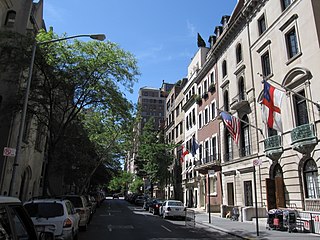
The Upper East Side, sometimes abbreviated UES, is a neighborhood in the borough of Manhattan in New York City, bounded approximately by 96th Street to the north, the East River to the east, 59th Street to the south, and Central Park and Fifth Avenue to the west. The area incorporates several smaller neighborhoods, including Lenox Hill, Carnegie Hill, and Yorkville. Once known as the Silk Stocking District, it has long been the most affluent neighborhood in New York City.

<span class="mw-page-title-main">Lincoln Park, Chicago</span> Community area in Chicago

Lincoln Park is a designated community area on the North Side of Chicago, Illinois. It is located west of Lincoln Park.

<span class="mw-page-title-main">Cabrini–Green Homes</span> Public housing development in Chicago

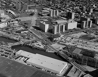
Cabrini–Green Homes was a Chicago Housing Authority (CHA) public housing project on the Near North Side of Chicago, Illinois. The Frances Cabrini Rowhouses and Extensions were south of Division Street, bordered by Larrabee Street to the west, Orleans Street to the east and Chicago Avenue to the south, with the William Green Homes to the northwest.

<span class="mw-page-title-main">Streeterville</span> Neighborhood in Chicago

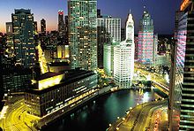
Streeterville is a neighborhood in the Near North Side community area of Chicago, Illinois, United States, north of the Chicago River. It is bounded by the river on the south, the Magnificent Mile portion of Michigan Avenue on the west, and Lake Michigan on the north and east, according to most sources, although the City of Chicago only recognizes a small portion of this region as Streeterville. Thus, it can be described as the Magnificent Mile plus all land east of it. The tourist attraction of Navy Pier and Ohio Street Beach extend out into the lake from southern Streeterville. To the north, the East Lake Shore Drive District, where the Drive curves around the shoreline, may be considered an extension the Gold Coast. The majority of the land in this neighborhood is reclaimed sandbar.

<span class="mw-page-title-main">North Park, Chicago</span> Community area in Chicago

North Park is one of 77 well-defined community areas of the City of Chicago. It is bordered by the North Shore Channel on the east, the Chicago River's North Branch and Foster Avenue on the south, Cicero Avenue on the west and Devon Avenue on the north.

<span class="mw-page-title-main">Turtle Bay, Manhattan</span> Neighborhood of Manhattan in New York City

Turtle Bay is a neighborhood in New York City, on the east side of Midtown Manhattan. It extends from roughly 43rd Street to 53rd Street, and eastward from Lexington Avenue to the East River's western branch. The neighborhood is the site of the headquarters of the United Nations and the Chrysler Building. The Tudor City apartment complex is next to the southeast corner of Turtle Bay.

<span class="mw-page-title-main">Austin, Chicago</span> Community area in Chicago

Austin is one of 77 community areas in Chicago. Located on the city's West Side, it is the third largest community area by population and the second-largest geographically. Austin's eastern boundary is the Belt Railway located just east of Cicero Avenue. Its northernmost border is the Milwaukee District / West Line. Its southernmost border is at Roosevelt Road from the Belt Railway west to Austin Boulevard. The northernmost portion, north of North Avenue, extends west to Harlem Avenue, abutting Elmwood Park. In addition to Elmwood Park, Austin also borders the suburbs of Cicero and Oak Park.

<span class="mw-page-title-main">Near South Side, Chicago</span> Community area in Chicago

The Near South Side is a community area of Chicago, Illinois, United States, just south of the downtown central business district, the Loop. The Near South Side's boundaries are as follows: North—Roosevelt Road ; South—26th Street; West—Chicago River between Roosevelt and 18th Street, Clark Street between 18th Street and Cermak Road, Federal between Cermak Road and the Stevenson Expressway just south of 25th Street, and Clark Street again between the Stevenson and 26th Street; and East—Lake Michigan.

<span class="mw-page-title-main">Near West Side, Chicago</span> Community area in Chicago

The Near West Side, one of the 77 community areas of Chicago, is on the West Side, west of the Chicago River and adjacent to the Loop. The Great Chicago Fire of 1871 started on the Near West Side. Waves of immigration shaped the history of the Near West Side of Chicago, including the founding of Hull House, a prominent settlement house. In the 19th century railroads became prominent features. In the mid-20th century, the area saw the development of freeways centered in the Jane Byrne Interchange.

<span class="mw-page-title-main">North Center, Chicago</span> Community area in Chicago

North Center is one of the 77 community areas of Chicago, Illinois, located in the city's North Side. North Center is bordered on the north by Montrose Avenue, on the south by Diversey Parkway, on the west by the Chicago River and on the east by Ravenswood Avenue; it includes the neighborhoods of North Center, Roscoe Village, St. Ben's, and Hamlin Park. The Brown Line of the Chicago 'L' has stops within the community area at Addison, Irving Park, and Montrose.

<span class="mw-page-title-main">West Town, Chicago</span> Community area in Chicago

West Town, northwest of the Loop on Chicago's West Side, is one of the city's officially designated community areas. Much of this area was historically part of Polish Downtown, along Western Avenue, which was then the city's western boundary. West Town was a collection of several distinct neighborhoods and the most populous community area until it was surpassed by Near West Side in the 1960s. The boundaries of the community area are the Chicago River to the east, the Union Pacific railroad tracks to the south, the former railroad tracks on Bloomingdale Avenue to the North, and an irregular western border to the west that includes the city park called Humboldt Park. Humboldt Park is also the name of the community area to West Town's west, Logan Square is to the north, Near North Side to the east, and Near West Side to the south. The collection of neighborhoods in West Town along with the neighborhoods of Bucktown and the eastern portion of Logan Square have been referred to by some media as the "Near Northwest Side".

<span class="mw-page-title-main">Lower West Side, Chicago</span> Community area in Chicago, Illinois, United States

Lower West Side is a community area on the West Side of Chicago, Illinois, United States. It is three miles southwest of the Chicago Loop and its main neighborhood is Pilsen. The Heart of Chicago is a neighborhood in the southwest corner of the Lower West Side.

<span class="mw-page-title-main">Little Italy, Chicago</span> Human settlement in Illinois, United States of America

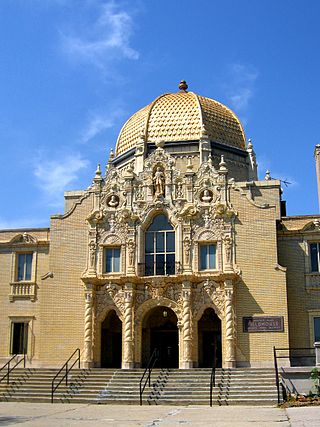
Little Italy, sometimes combined with University Village into one neighborhood, is on the Near West Side of Chicago, Illinois. The current boundaries of Little Italy are Ashland Avenue on the west and Interstate 90/94 on the east, the Eisenhower Expressway on the north and Roosevelt to the south. It lies between the east side of the University of Illinois at Chicago campus in the Illinois Medical District and the west side of the University of Illinois at Chicago campus. The community was once predominantly Italian immigrants but now is made up of diverse ethnic and socio-economic backgrounds as a result of immigration, urban renewal, gentrification and the growth of the resident student and faculty population of the University of Illinois at Chicago (UIC). Its Italian-American heritage is primarily evident in the Italian-American restaurants that once lined Taylor Street. The neighborhood is home to the National Italian American Sports Hall of Fame as well as the historic Roman Catholic churches Our Lady of Pompeii, Notre Dame de Chicago, and Holy Family.

<span class="mw-page-title-main">Halsted Street</span> Major north-south street in Chicago, Illinois, U.S.

Halsted Street is a major north-south street in the U.S. city of Chicago, Illinois.

<span class="mw-page-title-main">Old Town, Chicago</span> United States historic place in Chicago, Illinois

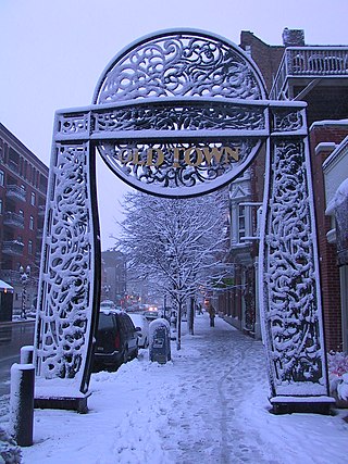
Old Town is a neighborhood and historic district in Near North Side and Lincoln Park, Chicago, Illinois, home to many of Chicago's older, Victorian-era buildings, including St. Michael's Church, one of seven buildings to survive the Great Chicago Fire.

The River North Gallery District or simply River North, in Chicago, is in the Near North Side, Chicago. It once hosted the largest concentration of art galleries in the United States outside of Manhattan. River North has experienced vast changes in the years 1990 - 2012, including the development of large high-rise buildings, nightclubs and restaurants. River North has become one of Chicago's top neighborhoods for nightlife especially on and around Hubbard Street. Today there are far fewer galleries but the artistic spirit remains, with regular art openings taking place as well as a Fall River North Design District Walk taking place every September.

Ogden Avenue is a street extending from the Near West Side of Chicago to Montgomery, Illinois. It was named for William B. Ogden, the first mayor of Chicago.

<span class="mw-page-title-main">Near North Career Metropolitan High School</span> School in Chicago, Illinois, United States

Near North Career Metropolitan High School was a public 4–year magnet high school located in the Old Town neighborhood on the Near North Side of Chicago, Illinois, United States. Operated by the Chicago Public Schools district, Near North opened in September 1979.

<span class="mw-page-title-main">West Side, Chicago</span> District in Illinois, United States

The West Side is one of the three major sections of the city of Chicago, Illinois, U.S. The other two sections within Chicago that associate with the West Side are the North Side and the South Side. The West Side consists of communities that are of historical, cultural, and ideological importance to the history and development of Chicago. On the flag of Chicago, the West Side is represented by the central white stripe.

References

  1. 1 2 "Near North Side". Geographic Names Information System . United States Geological Survey, United States Department of the Interior. January 7, 1998.
  2. 1 2 3 4 "Community Data Snapshot Near North Side" (PDF). Retrieved November 17, 2023.
  3. Patton, Lindsey Howald (November 16, 2011). "You Asked: What is McCormickville?". Museum Blog. Driehaus Museum . Retrieved March 15, 2015.
  4. "History". St. Michael in Old Town. 2015. Retrieved March 16, 2015.
  5. Maggio, Alice (May 26, 2005). "Ask the Librarian: Goose Island". Gapers Block. Retrieved May 17, 2007.
  6. Google Maps (January 14, 2019). 1600 N Kingsbury St to 1132 W Blackhawk St (Map). Retrieved September 8, 2023.
  7. Sightseeing, Wendella (January 2, 2019). "North Avenue/Sheffield Stop - Chicago Water Taxi". Chicago Water Taxi. Retrieved January 14, 2019.
  8. Ihejirika, Maudlyne (October 23, 2010). "Cabrini-Green's last stand: Families prepare to move out". Chicago Sun-Times . Archived from the original on March 8, 2014. Retrieved March 15, 2015.
  9. Zorbaugh, Harvey, (1929) The Gold Coast and the Slum: A Sociological Study of Chicago's Near North Side, Chicago: University of Chicago Press
  10. 1 2 3 Diesenhouse, Susan (2008). "River North: From gritty roots to urban chic". www.chicagotribune.com. Chicago Tribune. Retrieved July 11, 2008.
  11. "2007 LaSalle Bank Chicago Marathon Runner Information". www.chicagomarathon.com. LaSalle Bank. 2007. Archived from the original on October 12, 2011. Retrieved August 12, 2007.
  12. "Google Offices" . Retrieved July 12, 2009.
  13. "Our offices Archived 2013-02-13 at the Wayback Machine ." (Select United States of America) Etihad Airways. Retrieved on 11 February 2010.
  14. "Chicago Archived 2010-02-14 at the Wayback Machine ." Qatar Airways . Retrieved on February 9, 2009.
  15. "Contact Us." Wrigley Company. Retrieved on June 26, 2010.
  16. "Wrigley to relocate Global Headquarters to Goose Island". Mars.com. Mars Inc. Retrieved September 22, 2018.
  17. "World Airline Directory." Flight International . March 14–20, 1990. 127.
  18. "contact us". Indigo Airlines. November 9, 2000. Archived from the original on November 9, 2000. Retrieved September 1, 2009.
  19. Gallun, Alby (August 14, 2017). "Chicago Tribune moving offices to Prudential Plaza". ChicagoBusiness.com. Crain's. Retrieved September 22, 2018.
  20. "Frequently Asked Questions Archived 2010-03-08 at the Wayback Machine ." Potbelly Sandwich Works. Retrieved on February 24, 2010.
  21. Ori, Ryan (October 9, 2014). "Potbelly moving headquarters to West Loop". ChicagoBusiness.com. Crain's Chicago Business. Retrieved September 22, 2018.
  22. "Aldermanic Wards for the City of Chicago" (PDF). City of Chicago. Archived from the original (PDF) on December 1, 2017. Retrieved September 4, 2018.
  23. "Centennial List of Mayors, City Clerks, City Attorneys, City Treasurers, and Aldermen, elected by the people of the city of Chicago, from the incorporation of the city on March 4, 1837 to March 4, 1937, arranged in alphabetical order, showing the years during which each official held office". Chicago Historical Society. Archived from the original on September 4, 2018. Retrieved July 25, 2018.
  24. "A LOOK AT COOK". A Look at Cook. Archived from the original on August 18, 2018. Retrieved September 4, 2018.
  25. "Some Chicago GIS Data". University of Chicago Library. University of Chicago. March 18, 2015. Retrieved September 2, 2018.
  26. Germuska, Joe; Boyer, Brian. "The old and new ward maps, side-by-side". Chicago Tribune. Retrieved September 4, 2018.[ permanent dead link ]
  27. Dawson, Michael. "Chicago Democracy Project". Chicago Democracy Project. University of Chicago. Retrieved September 4, 2018.
  28. "Cook County Commissioner District Map". Cook County Government Open Data. Cook County. Retrieved September 25, 2018.
  29. 1 2 "Illinois House". Illinois Policy. April 20, 2016. Retrieved September 4, 2018.
  30. 1 2 "2001 Congressional District Maps and Boundary Descriptions". Elections.IL.gov. Illinois State Board of Elections. Retrieved September 22, 2018.
  31. 1 2 "Previous General Assemblies". Ilga.gov. Illinois General Assemblies. Retrieved September 22, 2018.
  32. 1 2 "Illinois Senate". Illinois Policy. April 20, 2016. Retrieved September 4, 2018.
  33. Ali, Tanveer (November 9, 2016). "How Every Chicago Neighborhood Voted In The 2016 Presidential Election". DNAInfo . Archived from the original on September 24, 2019. Retrieved October 4, 2019.
  34. Ali, Tanveer (November 9, 2012). "How Every Chicago Neighborhood Voted In The 2012 Presidential Election". DNAInfo . Archived from the original on February 3, 2019. Retrieved October 4, 2019.
  35. "Contacts". Consulate-General of the People's Republic of China in Chicago . Retrieved January 31, 2009.
  36. "Education Section's Map". Consulate-General of the People's Republic of China in Chicago . Retrieved January 31, 2009.
  37. "Consulate General". Consulate-General of Austria in Chicago. Archived from the original on July 22, 2012. Retrieved January 31, 2009.
  38. "Consular Information". Embassy of Bosnia and Herzegovina Washington, D.C. Archived from the original on February 8, 2009. Retrieved January 31, 2009.
  39. "Location". Consulate-General of Brazil in Chicago . Retrieved January 31, 2009.
  40. "Holidays". Consulate-General of Bulgaria in Chicago. Archived from the original on May 13, 2007. Retrieved January 31, 2009.
  41. "Oficinas Consulares en Estados Unidos". Embassy of Chile in Washington, D.C. Archived from the original on July 23, 2012. Retrieved January 31, 2009.
  42. "Dirección". Consulate-General of Colombia in Chicago. Retrieved January 31, 2009.
  43. "Home page". Consulate-General of Denmark in Chicago. Archived from the original on December 31, 2008. Retrieved January 31, 2009.
  44. "Visa and Other Consular Services". Embassy of Egypt in Washington, D.C. Archived from the original on January 27, 2009. Retrieved January 31, 2009.
  45. "Address, Contact and Office Hours". Consulate-General of Germany in Chicago. Archived from the original on January 6, 2009. Retrieved January 31, 2009.
  46. "Contact Us". Consulate-General of Greece in Chicago. Archived from the original on July 17, 2009. Retrieved January 31, 2009.
  47. "Home page". Consulate-General of India in Chicago. Archived from the original on July 15, 2011. Retrieved January 31, 2009.
  48. "Welcome!". Consulate-General of Ireland in Chicago . Retrieved January 31, 2009.
  49. "The Consulate General". Consulate-General of Italy in Chicago . Retrieved January 31, 2009.
  50. "Home Page". Consulate-General of Japan in Chicago . Retrieved January 31, 2009.
  51. "Contact Us". Consulate-General of South Korea in Chicago . Retrieved January 31, 2009.
  52. "Consular Information". Embassy of Lithuania in Washington, D.C. Retrieved January 31, 2009.
  53. "General Info". Consulate-General of Poland in Chicago. Archived from the original on July 9, 2009. Retrieved January 31, 2009.
  54. "Contact". Consulate-General of Serbia in Chicago. Archived from the original on June 20, 2008. Retrieved January 31, 2009.
  55. "Consulate General Chicago". Federal Department of Foreign Affairs . Retrieved January 31, 2009.
  56. "Contact Royal Thai Consulate-General, Chicago". Consulate-General of Thailand in Chicago . Retrieved January 31, 2009.
  57. "Chicago". UK in the USA. Archived from the original on January 21, 2009. Retrieved January 31, 2009.
  58. "Index". Consulate-General of Ukraine in Chicago . Retrieved January 31, 2009.
  59. "Austrian Consulate General, Chicago: Other Austrian Offices". Austrian Foreign Ministry. 2009. Archived from the original on September 12, 2013. Retrieved September 3, 2018.
  60. "Chicago". SkyTeam. Archived from the original on January 29, 2009. Retrieved January 31, 2009.
  61. "Near North/West/Central Elementary Schools Archived June 12, 2009, at the Wayback Machine " (Archive). Chicago Public Schools. May 17, 2013. Retrieved on May 25, 2015.
  62. "Admissions". Ogden International School. Retrieved April 4, 2020. Graduates of 8th grade at Jenner Campus can automatically enroll in 9th grade at Ogden's West Campus. If your child graduated from a different middle school [...]
  63. "HS North/Near North." Chicago Public Schools. 2013. Retrieved on September 30, 2016.
  64. "Conor Allen Just 20th Chicago-Born Player Ever to Reach NHL". Archived from the original on September 25, 2017. Retrieved May 14, 2021.
  65. "Major Henry Alexuis Courtney, Jr., USMCR". Who's Who in Marine Corps History. History Division, United States Marine Corps. Archived from the original on August 6, 2007. Retrieved November 3, 2007.
  66. "Henry A Courtney, Chicago, Cook, Illinois". 1940 United States census . p. 103-2665.
  67. "NELLIE GRANT DIES; VICTIM OF LONG ILLNESS: Daughter of President Had Famous Career". Chicago Tribune . August 31, 1922.
  68. "EX-GOV. GREEN DIES AT 61: WON ILLINOIS TWICE; JAILED CAPONE, PALS Loses in Valiant Cancer Fight". Chicago Tribune . February 21, 1958. p. 1.
  69. Kenan Heise (May 9, 1985). "Robert Halperin, 77, War Hero, Executive". Chicago Tribune. Retrieved July 11, 2011.
  70. "Chicago rapper Polo G explains why he is different". Rolling Out. December 25, 2018. Retrieved October 11, 2019.
  71. Rodkin, Dennis (March 12, 2020). "Gene Siskel's former Gold Coast co-op for sale". Crain's Chicago Business . Retrieved March 26, 2021.