Calumet Heights, Chicago

Last updated

Calumet Heights
Community Area 48 - Calumet Heights
Calumet Heights.PNG
US-IL-Chicago-CA48.svg
Location within the city of Chicago
Coordinates: 41°43′42″N87°34′47″W / 41.72833°N 87.57972°W / 41.72833; -87.57972 Coordinates: 41°43′42″N87°34′47″W / 41.72833°N 87.57972°W / 41.72833; -87.57972
CountryUnited States
StateIllinois
County Cook
CityChicago
Neighborhoods
list
Area
  Total1.77 sq mi (4.58 km2)
Population
 (2020)
  Total13,088
  Density7,400/sq mi (2,900/km2)
Demographics 2015 [1]
   White 2.24%
  Black93.47%
  Hispanic3.23%
  Asian0.04%
  Other1.03%
Time zone UTC-6 (CST)
  Summer (DST) UTC-5 (CDT)
ZIP Codes
parts of 60617, 60619
Median household income $49,923 [1]
Source: U.S. Census, Record Information Services

Calumet Heights, located on the South Side of the city, is one of the 77 well defined community areas of Chicago, Illinois. Calumet Heights is bounded by 87th Street on the north, South Chicago Avenue on the east, and railroad lines on the west and south (along 95th Street).

Contents

History

Calumet Heights was swampy and relatively unoccupied throughout the nineteenth century. In 1870, the Calumet and Chicago Canal Dock Company purchased the Stony Island Ridge. [2] A railroad was built in 1881 along the western border of Calumet Heights leading to the development of the neighborhood. [3] The area became part of the Village of Hyde Park in 1889. Shortly thereafter, Hyde Park Township was annexed by Chicago. [2]

During the Chicago Freedom Movement, Calumet Heights was one of the few areas in which Martin Luther King Jr. received a positive reception in which he was hosted by a Calumet Heights business owner. During this same period, Dr. King was hit with a brick during a march in a white-majority area of Chicago. [4] [5]

Demographics

The area that is now Calumet Heights was initially settled by Irish and German immigrants. Those residents were eventually replaced by Italian, Polish and Yugoslavian immigrants. In the 1960s, the first African American families moved to Calumet Heights and received a hostile reception. Unlike other communities that underwent white flight during this period, Calumet Heights maintained much of its wealth. [6] As of 2015, the median income in Calumet Heights is slightly greater than that of Chicago at-large. This includes a greater percentage of Calumet Heights residents making $75,000 to $149,999 than Chicago at-large. [1]

According to a 2017 analysis by the Chicago Metropolitan Agency for Planning, there were 13,732 people and 5,369 households in Calumet Heights. The racial makeup of the area was 2.2% White, 93.5% African American, and 1.0% from other races. Residents who self-identify as Hispanic or Latino of any race were 3.2% of the population. In the area, the population was spread out, with 20.1% under the age of 19, 13.3% from 20 to 34, 20.6% from 35 to 49, 21.9% from 50 to 64, and 24.2% who were 65 years of age or older. The median age was 46 years. [1]

Economy

An analysis by the University of Illinois at Chicago's Great Cities Institute estimates there are 2,327 jobs in the Calumet Heights community area. [7] The top employing industry sector in the Calumet Heights area is healthcare (58.7%). Healthcare is followed by accommodation and food (12.1%), retail trade (8.4%), administration (3.6%) and other service (3.5%). Over half of the workers in these fields reside outside of Chicago. [1] 56% of Calumet Heights residents are in the labor force. 83% of those are considered to be employed and 17% to be unemployed. [1] The top 5 employing industry sectors of community residents are healthcare (18.5%), education (14.1%), public administration (9.8%), administration (8.4%) and retail trade (8.2%). Over one third of Calumet Heights residents commute to Chicago's central business district and a little less than one third of Calumet Heights residents commute outside of Chicago. [1]

The Commercial Avenue TIF district is partially located in Calumet Heights. [8] Calumet Heights also includes a portion of Chicago Enterprise Zone 3. An enterprise zone is an economic development tool created by state statute which allows for various tax exemptions on activities related to development, including an exemption on taxes paid on building materials. [9] [10]

Education

The Bronzeville Children's Museum at 9301 South Stony Island Avenue 20100409 Bronzeville Childrens Museum.jpg
The Bronzeville Children's Museum at 9301 South Stony Island Avenue

Calumet Heights is part of City of Chicago School District #299 and City Colleges of Chicago District #508. The nearest City Colleges campus was Olive–Harvey College in Pullman. A high school diploma had been earned by 88.5% of Calumet Heights residents and a bachelor's degree had been earned by 27.4% of residents. [1] The Bronzeville Children's Museum, the only children's museum in the United States focused on African-American history moved to Calumet Heights from Evergreen Park, Illinois in the early 2000s. [11]

Geography

Calumet Heights is bounded by 87th Street on the north, South Chicago Avenue on the east, and railroad lines on the west and south (along 95th Street). It includes the neighborhoods of Calumet Heights, Pill Hill, and Stony Island Heights. [2] Beginning at about 91st Street and Constance Avenue is the geographical feature for which it was named, a stony hill that was once an island when glacial Lake Chicago covered the area thousands of years ago. Early pioneers gave this hill the name Stony Island because at a distance it looked like an island in set a trackless prairie sea. (See also the nearby Blue Island).

Politics

Calumet Heights is a stronghold for the Democratic Party. In the 2016 presidential election, Calumet Heights cast 7,840 votes for Hillary Clinton and cast 184 votes Donald Trump. Despite this landslide victory, it was actually Clinton's 20th largest margin of victory by percentage points in the 76 community areas she won. [12] In the 2012 presidential election, Calumet Heights cast 8,727 votes for Barack Obama and 95 votes for Mitt Romney. It was Obama's 18th largest margin of victory by percentage points in the 76 community areas he won. [13]

At the local level, Calumet Heights is located in Chicago's 7th, 8th, and 10th represented by Democrats Gregory Mitchell, Michelle A. Harris, and Susie Sadlowski Garza respectively. [14] [15] [16]

Notable people

Related Research Articles

<span class="mw-page-title-main">Pullman, Chicago</span> Community area in Chicago

Pullman, one of Chicago's 77 defined community areas, is a neighborhood located on the city's South Side. Twelve miles from the Chicago Loop, Pullman is situated adjacent to Lake Calumet.

<span class="mw-page-title-main">Austin, Chicago</span> Community area in Chicago

Austin is one of 77 community areas in Chicago Located on the city's West Side, it is the third largest community area by population and the second-largest geographically. Austin's eastern boundary is the Belt Railway located just east of Cicero Avenue. Its northernmost border is the Milwaukee District / West Line. Its southernmost border is at Roosevelt Road from the Belt Railway west to Austin Boulevard. The northernmost portion, north of North Avenue, extends west to Harlem Avenue, abutting Elmwood Park. In addition to Elmwood Park, Austin also borders the suburbs of Cicero and Oak Park.

<span class="mw-page-title-main">Archer Heights, Chicago</span> Community area in Chicago

Archer Heights is a community area in Chicago, Illinois, one of the 77 official community areas of Chicago.

<span class="mw-page-title-main">Mount Greenwood, Chicago</span> Community area in Chicago

Mount Greenwood is one of the 77 community areas in Chicago. The 74th numbered area, it is about 14 miles (23 km) southwest of the Loop. It is surrounded by the neighborhoods of Beverly and Morgan Park to the east, the suburb of Evergreen Park to the north, the suburb of Oak Lawn to the west, and the suburbs of Merrionette Park and Alsip to the south. Mount Greenwood is known as the home of many Chicago firefighters, Chicago police officers, and union workers.

<span class="mw-page-title-main">West Pullman, Chicago</span> Community area in Chicago

West Pullman is a neighborhood located on the far south side of the city of Chicago, Illinois. It is one of the 77 official community areas of Chicago. The Neighborhood of West Pullman was largely inhabited by workers of the Pullman Train Company who were looking to escape the grip of the company town Pullman. The commercial corridor of Kensington/115th Street was one of many Italian communities within Chicago.

<span class="mw-page-title-main">Montclare, Chicago</span> Community area in Chicago

Montclare is one of 77 officially designated Chicago community areas located on the Northwest Side of the City of Chicago, Illinois.

<span class="mw-page-title-main">Douglas, Chicago</span> Community area in Illinois, United States

Douglas, on the South Side of Chicago, Illinois, is one of Chicago's 77 community areas. The neighborhood is named for Stephen A. Douglas, Illinois politician and Abraham Lincoln's political foe, whose estate included a tract of land given to the federal government. This tract later was developed for use as the Civil War Union training and prison camp, Camp Douglas, located in what is now the eastern portion of the Douglas neighborhood. Douglas gave that part of his estate at Cottage Grove and 35th to the Old University of Chicago. The Chicago 2016 Olympic bid planned for the Olympic Village to be constructed on a 37-acre (15 ha) truck parking lot, south of McCormick Place, that is mostly in the Douglas community area and partly in the Near South Side.

<span class="mw-page-title-main">Lower West Side, Chicago</span> Community area in Chicago, Illinois, United States

Lower West Side is a community area on the West Side of Chicago, Illinois, United States. It is three miles southwest of the Chicago Loop and its main neighborhood is Pilsen. The Heart of Chicago is a neighborhood in the southwest corner of the Lower West Side.

<span class="mw-page-title-main">Oakland, Chicago</span> Community area in Chicago

Oakland, located on the South Side of Chicago, Illinois, USA, is one of 77 officially designated Chicago community areas. Bordered by 35th and 43rd Streets, Cottage Grove Avenue and Lake Shore Drive, The Oakland area was constructed between 1872 and 1905. Some of Chicago's great old homes may be seen on Drexel Boulevard. The late 19th-century Monument Baptist Church on Oakwood Blvd. is modeled after Boston's Trinity Church. Oakwood /41st Street Beach in Burnham Park is at 4100 S. Lake Shore Drive. With an area of only 0.6 sq mi Oakland is the smallest community area by area in Chicago.

<span class="mw-page-title-main">Avalon Park, Chicago</span> Community area in Chicago

Avalon Park, located on the south side of the U.S. city of Chicago, Illinois, is one of the city's 77 semi-official community areas and is named after its main park. Its boundaries are 76th St. to the north, South Chicago Ave. to the east and 87th St. to the south. The community area includes the neighborhoods of Avalon Park, Marynook and Stony Island Park.

<span class="mw-page-title-main">Chatham, Chicago</span> Community area in Chicago

Chatham is one of the 77 community areas of the city of Chicago, Illinois. It is located on the city's South Side. It includes the neighborhoods of Chatham-Avalon, Chatham Club, Chesterfield, East Chatham, West Chatham and the northern portion of West Chesterfield. Its residents are predominantly African American, and it is home to former Senator Roland Burris. Housing many city employees and other officials, Chatham has been a central area for Chicago's middle-class African Americans since the late 1950s.

<span class="mw-page-title-main">South Chicago, Chicago</span> Community area in Chicago

South Chicago, formerly known as Ainsworth, is one of the 77 well-defined community areas of Chicago, Illinois.

<span class="mw-page-title-main">Burnside, Chicago</span> Community area in Chicago

Burnside is one of the 77 community areas in Chicago. The 47th numbered area, it is located on the city's far south side. This area is also called "The Triangle" by locals, as it is bordered by railroad tracks on every side; the Canadian National Railway on the west, the Union Pacific Railroad on the south and the Norfolk Southern Railway on the east. With a population of 2,254 in 2016, it is the least populous of the community areas, as well as the second smallest by area after Oakland.

<span class="mw-page-title-main">South Deering, Chicago</span> Community area in Chicago

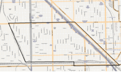
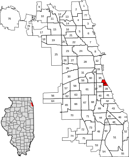
South Deering, located on Chicago's far South Side, is the largest of the 77 official community areas of that city. Primarily an industrial area, a small residential neighborhood exists in the northeast corner and Lake Calumet takes up a large portion of the area. 80% of the community area is zoned as industrial, natural wetlands, or parks. The remaining 20% is zoned for residential and small-scale commercial uses. It is part of the 10th Ward, once under the control of former Richard J. Daley ally Alderman Edward Vrdolyak.

<span class="mw-page-title-main">East Side, Chicago</span> Community area in Chicago

East Side is one of the 77 official community areas of Chicago, Illinois. It is on the far south side of the city, between the Calumet River and the Illinois-Indiana state line, 13 miles (21 km) south of downtown Chicago. The neighborhood has a park on Lake Michigan, Calumet Park, and a forest, Eggers Grove Forest Preserve. The forest preserve has hiking/walking trails, picnic grounds and birdwatching. It is served by U.S. Highway 12, U.S. Highway 20, and U.S. Highway 41.

<span class="mw-page-title-main">Riverdale, Chicago</span> Community area in Chicago

Riverdale is one of the 77 official community areas of Chicago, Illinois and is located on the city's far south side.

<span class="mw-page-title-main">Hegewisch, Chicago</span> Community area in Chicago

Hegewisch is one of the 77 community areas of Chicago, Illinois, located on the city's far south side. It is bordered by the neighborhoods of Riverdale and South Deering to the west, the East Side to the north, the village of Burnham to the south and the city of Hammond, Indiana to the east. The community area is named for Adolph Hegewisch, the president of U.S. Rolling Stock Company who hoped to establish "an ideal workingman's community" when he laid out the town along a rail line in 1883, six years before Chicago annexed the town.

<span class="mw-page-title-main">O'Hare, Chicago</span> Community area in Chicago

O'Hare, located on the far north side of Chicago, is one of the city's 77 community areas. O'Hare International Airport is located within the boundaries of this community area. This community area is the only one that extends outside Cook County; the western edge is in DuPage County.

Illinois's 2nd congressional district is a congressional district in the U.S. state of Illinois. Based in the south suburbs of Chicago, the district includes southern Cook county, eastern Will county, and Kankakee county, as well as the city of Chicago's far southeast side.

<span class="mw-page-title-main">Pill Hill, Chicago</span> Neighborhood in Calumet Heights, Chicago

Pill Hill is a neighborhood in the Calumet Heights community area on the South Side of Chicago, Illinois, United States.

References

  1. 1 2 3 4 5 6 7 8 "Community Data Snapshot - Calumet Heights" (PDF). cmap.illinois.gov. MetroPulse. Retrieved November 28, 2017.
  2. 1 2 3 Kouri, Charles (November 22, 1991). "Upwardly mobile Calumet Heights a 'high-end' community". Chicago Tribune via ProQuest.
  3. Encyclopaedia Chicago: Calumet Heights
  4. Howard, Robert (May 4, 2007). "Soul Queen - Helen Maybell Anglin's legendary buffet fed everyone from Ali to MLK" . Chicago Sun-Times . Chicago, Illinois . Retrieved April 16, 2018 via NewsBank.
  5. Isserman, Maurice; Kazin, Michael (2000). America Divided: The Civil War of the 1960s . Oxford University Press. p.  200. ISBN   0-19-509190-6. See also: Miller, Keith D. (1998). Voice of Deliverance: The Language of Martin Luther King Jr. and Its Sources. University of Georgia Press. p. 139. ISBN   0-8203-2013-7.
  6. White, John C. (February 6, 1983). "A neighborhood success story: Community changes color, but remains stable". Chicago Tribune . p. 5 via ProQuest.
  7. "Economic Fact Sheet #1: Chicago and Cook County Economic Trends" (PDF). University of Illinois Chicago. July 11, 2016. Retrieved July 12, 2017.
  8. "Commercial Avenue TIF". City of Chicago Department of Planning and Development. Retrieved January 3, 2018.
  9. "Chicago III (2016)" (PDF). Illinois Department of Commerce and Economic Opportunity. January 23, 2018. Archived from the original (PDF) on April 17, 2018. Retrieved April 17, 2018.
  10. "Illinois Enterprise Zone Act (20 ILCS 655/)". Illinois General Assembly. February 28, 1990. Retrieved April 16, 2018.
  11. Patterson, Melissa (August 19, 2008). "Museum a place for kids to learn; African-American history and culture the focus of Far South Side institution that just keeps growing". Chicago Tribune : 1, section ?. ProQuest   420731623.
  12. Ali, Tanveer (November 9, 2016). "How Every Chicago Neighborhood Voted In The 2016 Presidential Election". Chicago, Illinois: DNAinfo.com. Archived from the original on March 17, 2017. Retrieved March 16, 2017.
  13. Ali, Tanveer (November 7, 2012). "How Every Chicago Neighborhood Voted In The 2012 Presidential Election". Chicago, Illinois: DNAinfo.com. Archived from the original on March 17, 2017. Retrieved March 16, 2017.
  14. Connolly, Colleen (February 6, 2015). "Get to Know Your Ward: 7th Ward". Ward Room. WMAQ-TV . Retrieved December 25, 2017.
  15. Connolly, Colleen (February 6, 2015). "Get to Know Your Ward: 8th Ward". Ward Room. WMAQ-TV . Retrieved December 27, 2017.
  16. Connolly, Colleen (February 6, 2015). "Get to Know Your Ward: 10th Ward". Ward Room. WMAQ-TV . Retrieved December 27, 2017.
  17. Nickeas, Peter (February 23, 2019). "Blaze strikes Clerk Dorothy Brown's home". Chicago Tribune . Retrieved February 23, 2019.
  18. Bazer, Mark (September 17, 2014). "Common is Back in the Neighborhood". No. October 2014. Chicago magazine.
  19. Mitchell, Greg (March 20, 2015). "Greg Mitchell - Office running for: Alderman, 7th Ward" (Interview). Interviewed by Chicago Sun-Times Editorial Board. Chicago, Illinois: Chicago Sun-Times . Retrieved December 27, 2018.