Edison Park, Chicago

Last updated
Edison Park
Community Area 09 - Edison Park
Edison Park Chicago.JPG
Fieldhouse in Edison Park on the Northwest Highway
US-IL-Chicago-CA09.svg
Location within the city of Chicago
Coordinates: 42°0.6′N87°48.6′W / 42.0100°N 87.8100°W / 42.0100; -87.8100
CountryUnited States
StateIllinois
County Cook
CityChicago
Neighborhoods
Area
  Total1.17 sq mi (3.03 km2)
Population
 (2020)
  Total11,525
  Density9,900/sq mi (3,800/km2)
Demographics 2015 [1]
   White 87.32%
  Black1.07%
  Hispanic9.46%
  Asian1.46%
  Other0.70%
Educational Attainment 2015 [1]
  High School Diploma or Higher94.8%
  Bachelor's Degree or Higher46.3%
Time zone UTC-6 (CST)
  Summer (DST) UTC-5 (CDT)
ZIP Codes
part of 60631
Median household income [2] $86,300 [1]
Source: U.S. Census, Record Information Services

Edison Park (formerly Canfield) is one of the 77 community areas of Chicago. It is located on the North Side, Chicago, Illinois, United States.

Contents

It consists entirely of the Edison Park neighborhood, and is named after Thomas Alva Edison, [3] who gave his blessing to this community namesake in 1890. According to the 2000 Census, its population is 11,259. Edison Park has one of the highest concentrations of Irish ancestry in Chicago, where they make up over three-fourths of the neighborhood's population.

Located between the Des Plaines River and the Chicago River, this area served as a local watershed divide. The Des Plaines River feeds into the Illinois River and the Mississippi River to reach the Gulf of Mexico. Like nearby Portage Park, Edison Park was a common portage for early travelers, who would carry their canoes across it.

History

Edison Park's settlement history dates back to 1834 and the arrival of pioneers John and Katherine Ebinger along with their 21-year-old son Christian Ebinger and his new bride, the former Barbara Ruehle. The Ebingers had emigrated from Stuttgart, Germany, to Ann Arbor, Michigan, and then to Chicago seeking suitable farmland, but had found it too swampy. [4] As they traveled northwest from Chicago on the Indian trail to Milwaukee, Wisconsin (now Milwaukee Avenue), they crossed the North Branch of the Chicago River. However, their only horse was bitten by a snake and died, leaving them stranded. Consequently, the Ebingers decided to settle between what became Touhy and Devon Avenues. They laid claim to 80 acres around their single-story 12x14 foot cabin, and were soon joined by Christian's older brothers (Frederick and John) along with their sister Elizabeth and her husband John Plank. That area eventually became Niles Township, but as their joint families expanded, the Ebingers moved across Harlem Avenue into what became Maine Township. Barbara Ruehle Ebinger gave birth to a son, Christian Jr., in November 1834. He became the first white child born in the area, which became known as "Dutchman's Point" because of their German ancestry. The senior Christian Ebinger was a friend of local Native Americans in the area, among them Chief Blackhawk and Billy Caldwell. Christian Ebinger Jr. became the first minister to be ordained in their German Evangelical Association, and then was elected the Village Collector (1852), Village Assessor (1852-1865) and Highway Commissioner (1854-1858); he died in 1879, survived by seven children, including another Christian Ebinger. [5]

Eventually, Chicago grew and annexed part of Ebinger's homestead. Germans began moving into nearby Norwood Park (originally settled by English immigrants; but the German Evangelicals established a church as well as a Sunday School in the Ebinger home). Developers targeted the area circa 1868, Norwood Park incorporated out of Niles Township in 1874, and was annexed to Chicago in 1893. [6] It was a stop on the Chicago and Milwaukee Railroad (later the Chicago and North Western Railway line) before Park Ridge, Illinois (in Maine Township and also partly from what was once Ebinger property), and became a streetcar suburb in the 20th century. [7] Today, its oldest church building, a frame construction dating from 1894 and now known as One Hope United Methodist Church, traces its ministry's beginnings to Christian Ebinger (Methodists having united with the historic United Brethren congregation circa 1960), and a modern Ebinger descendant became a Methodist pastor near Baltimore, Maryland. [8] [9]

Adjacent to the north, Edison Park (originally known as "Canfield") also developed around an intermediate railway stop between Norwood Park and Park Ridge. [10] [8] It incorporated as a village in 1881 [11] and developers promoted the availability of electricity; with the blessing of Thomas Alva Edison it renamed itself Edison Park in 1890. [3] Chicago annexed Edison Park on November 8, 1910. [12] A local public elementary school was named after Christian Ebinger. [13] According to the 2000 Census discussed below, Edison Park's population is 11,259.

Demographics

Historical population
CensusPop.Note
1930 5,370
1940 5,99911.7%
1950 7,84330.7%
1960 12,56860.2%
1970 13,0764.0%
1980 12,457−4.7%
1990 11,426−8.3%
2000 11,178−2.2%
2010 11,1870.1%
2020 11,5253.0%
U.S. Decennial Census [1] [14]

According to a 2016 analysis by the Chicago Metropolitan Agency for Planning, there were 11,208 people and 4,400 households in Edison Park. The racial makeup of the area was 87.3% White, 1.1% African American, 1.5% Asian, and 0.7% from other races. Hispanic or Latino residents of any race were 9.5% of the population. In the area, the population was spread out, with 21.9% under the age of 19, 19.5% from 20 to 34, 23.7% from 35 to 49, 19.6% from 50 to 64, and 15.2% who were 65 years of age or older. The median age was 39 years. [1]

The median household income was $86,300 compared to a median income of $47,831 for Chicago at-large. The area had an Income distribution in which 8.2% of households earned less than $25,000 annually; 19.7% of households earned between $25,000 and $49,999; 14.7% of households earned between $50,000 and $74,999; 16.4% of households earned between $75,000 and $99,999; 16.6% of households earned between $100,000 and $149,999 and 24.4% of households earned more than $150,000. This is compared to a distribution of 28.8%, 22.8%, 16.1%, 10.7%, 11.3% and 10.3% for Chicago at large. [1]

Arts and culture

Edison Park Fest has been held in the area since 1972. [15]

Reaction (Chicago) released album "Edison Park" on January 15, 2015. The band explains the title was selected because Edison Park was "the neighborhood in Chicago where we used to rehearse... It's a time in our lives when possibilities seemed endless." Their album cover features Edison Park's commuter Rail station. [16]

Government

Edison Park has narrowly gone for the Democratic Party in the past two presidential elections. In the 2016 presidential election, Edison Park cast 2,910 votes for Hillary Clinton and cast 2,653 votes Donald Trump. [17] In the 2012 presidential election, Edison Park cast 2,736 votes for Barack Obama and cast 2,525 votes for Mitt Romney. [18]

Edison Park is entirely within the 41st ward in the Chicago City Council, where it is represented by Alderman Anthony Napolitano, who is the only Republican member of the City Council as of 2019. [19]

Aldermen who have represented Edison Park since 1893 [20] [21] [22] [23] [24]
Years27th Ward a 41st Ward
1893 – 1894Mathew J. Conway, RepublicanFrederick F. Haussen, RepublicanNo such ward
1894 – 1895Hubert W. Butler, Republican
1895 – 1897George S. Foster, Democratic
1897 – 1899Spencer S. Kimbell, Republican
1899 – 1900Arthur F. Keeney, Republican
1900 – 1902Henry Wulff, Independent
1902 – 1903Hubert W. Butler, Republican
1903 – 1905Silas F. Leachman, Democratic
1905 – 1906Henry J. Siewert, Republican
1906 – 1908Hans Blase, Democratic
1908 – 1909James F. Clancy, Republican
1909 – 1910Joseph F. Capp, Republican
1910 – 1911Frank J. Wilson, Democratic
1911 – 1913Jens N. Hyldahl, Democratic
1913 – 1914George E. Trebing, Democratic
1914 – 1915Oliver L. Watson, Independent
1915 – 1919John C. Kennedy, Socialist
1919 – 1920Edward R. Armitage, Republican
1920 – 1923Christ A. Jensen, Democratic
1923 – 1930 Not in wardThomas J. Bowler, Democratic
1930 – 1931Vacant
1931 – 1935James C. Moreland, Republican
1935 – 1947William J. Cowhey, Democratic
1947 – 1958Joseph P. Immel, Jr., Republican
1958 – 1959Vacant
1959 – 1963Harry Bell, Democratic
1963 – 1972 Edward T. Scholl, Republican
1972 – 1973Vacant
1973 – 1991 Roman Pucinski, Democratic
1991 – 2011 Brian Doherty, Republican
2011 – 2015 Mary O'Connor, Democratic
2015 – present Anthony Napolitano, Republican
^a Prior to 1923 Chicago comprised 35 wards, each electing two aldermen in staggered two-year terms. [20]

Infrastructure

Transportation

The Union Pacific / Northwest Line has a station in the Edison Park community.

Notable people

Related Research Articles

<span class="mw-page-title-main">Niles, Illinois</span> Village in the United States

Niles is a village in Cook County, Illinois, United States, located in the townships of Maine and Niles, directly neighboring the City of Chicago's far northwest border. Per the 2020 census, the population was 30,912. The current mayor of Niles is George Alpogianis.

<span class="mw-page-title-main">Bridgeport, Chicago</span> Community area in Chicago, Illinois

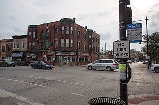
Bridgeport is one of the 77 community areas in Chicago, on the city's South Side, bounded on the north by the South Branch of the Chicago River, on the west by Bubbly Creek, on the south by Pershing Road, and on the east by the Union Pacific railroad tracks. Neighboring communities are Pilsen across the river to the north, McKinley Park to the west, Canaryville to the south, and Armour Square to the east. Bridgeport has been the home of five Chicago mayors. Once known for its racial intolerance, Bridgeport today ranks as one of the city's most diverse neighborhoods.

<span class="mw-page-title-main">Norwood Park, Chicago</span> Community area in Chicago

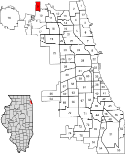
Norwood Park is one of the 77 Chicago community areas. It encompasses the smaller neighborhoods of Big Oaks, Norwood Park East, Norwood Park West, Old Norwood Park, Oriole Park, and Union Ridge.

<span class="mw-page-title-main">Austin, Chicago</span> Community area in Chicago

Austin is one of 77 community areas in Chicago. Located on the city's West Side, it is the third largest community area by population and the second-largest geographically. Austin's eastern boundary is the Belt Railway located just east of Cicero Avenue. Its northernmost border is the Milwaukee District / West Line. Its southernmost border is at Roosevelt Road from the Belt Railway west to Austin Boulevard. The northernmost portion, north of North Avenue, extends west to Harlem Avenue, abutting Elmwood Park. In addition to Elmwood Park, Austin also borders the suburbs of Cicero and Oak Park.

<span class="mw-page-title-main">Archer Heights, Chicago</span> Community area in Chicago

Archer Heights is a community area in Chicago, Illinois, one of the 77 official community areas of Chicago.

<span class="mw-page-title-main">Mount Greenwood, Chicago</span> Community area in Chicago

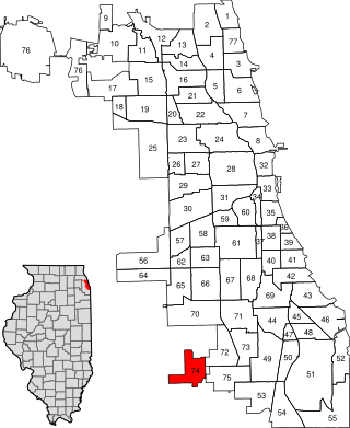
Mount Greenwood is one of the 77 community areas in Chicago. The 74th numbered area, it is about 14 miles (23 km) southwest of the Loop. It is surrounded by the neighborhoods of Beverly and Morgan Park to the east, the suburb of Evergreen Park to the north, the suburb of Oak Lawn to the west, and the suburbs of Merrionette Park and Alsip to the south. Mount Greenwood is known as the home of many Chicago firefighters, Chicago police officers, and union workers.

<span class="mw-page-title-main">West Pullman, Chicago</span> Community area in Chicago

West Pullman is a neighborhood located on the far south side of the city of Chicago, Illinois. It is one of the 77 official community areas of Chicago. The Neighborhood of West Pullman was largely inhabited by workers of the Pullman Train Company who were looking to escape the grip of the company town Pullman. The commercial corridor of Kensington/115th Street was one of many Italian communities within Chicago.

<span class="mw-page-title-main">South Lawndale, Chicago</span> Community area in Chicago

South Lawndale is a community area on the West Side of Chicago, Illinois. Over 80% of the residents are of Mexican descent and the community is home to the largest foreign-born Mexican population in Chicago.

<span class="mw-page-title-main">Avalon Park, Chicago</span> Community area in Chicago

Avalon Park, located on the south side of the U.S. city of Chicago, Illinois, is one of the city's 77 semi-official community areas and is named after its main park. Its boundaries are 76th St. to the north, South Chicago Ave. to the east and 87th St. to the south. The community area includes the neighborhoods of Avalon Park, Marynook and Stony Island Park.

<span class="mw-page-title-main">Burnside, Chicago</span> Community area in Chicago

Burnside is one of the 77 community areas in Chicago. The 47th numbered area, it is located on the city's far south side. This area is also called "The Triangle" by locals, as it is bordered by railroad tracks on every side; the Canadian National Railway on the west, the Union Pacific Railroad on the south and the Norfolk Southern Railway on the east. With a population of 2,254 in 2016, it is the least populous of the community areas, as well as the second smallest by area after Oakland.

<span class="mw-page-title-main">Calumet Heights, Chicago</span> Community area in Chicago

Calumet Heights, located on the South Side of the city, is one of the 77 well defined community areas of Chicago, Illinois. Calumet Heights is bounded by 87th Street on the north, South Chicago Avenue on the east, and railroad lines on the west and south.

<span class="mw-page-title-main">Roseland, Chicago</span> Community area in Chicago

Roseland is one of the 77 official community areas of Chicago, Illinois, located on the far south side of the city. It includes the neighborhoods of Fernwood, Princeton Park, Lilydale, the southern portion of West Chesterfield, Rosemoor, Sheldon Heights and West Roseland.

<span class="mw-page-title-main">Riverdale, Chicago</span> Community area in Chicago

Riverdale is one of the 77 official community areas of Chicago, Illinois and is located on the city's far south side.

<span class="mw-page-title-main">Hegewisch, Chicago</span> Community area in Chicago

Hegewisch is one of the 77 community areas of Chicago, Illinois, located on the city's far south side. It is bordered by the neighborhoods of Riverdale and South Deering to the west, the East Side to the north, the village of Burnham to the south and the city of Hammond, Indiana to the east. The community area is named for Adolph Hegewisch, the president of U.S. Rolling Stock Company who hoped to establish "an ideal workingman's community" when he laid out the town along a rail line in 1883, six years before Chicago annexed the town.

<span class="mw-page-title-main">O'Hare, Chicago</span> Community area in Chicago

O'Hare, located on the far north side of Chicago, is one of the city's 77 community areas. O'Hare International Airport is located within the boundaries of this community area. This community area is the only one that extends outside Cook County; the western edge is in DuPage County.

Brian G. Doherty was the alderman of the 41st Ward of the City of Chicago from 1991 to 2011. First elected to the Chicago City Council in 1991 when he defeated longtime incumbent Roman Pucinski, Doherty represented portions of the city's Northwest Side, including O'Hare International Airport. In 2010, Doherty won the Republican nomination for Illinois State Senate District 10 to replace retiring Senator James DeLeo (D-Chicago), but he lost the general election to John Mulroe. Doherty did not seek re-election after his defeat in the Senate contest and left office in 2011.

<span class="mw-page-title-main">John Mulroe</span> American politician and judge

John G. Mulroe is a judge of the Circuit Court of Cook County and lawyer from Chicago, Illinois. Between August 2010 and June 2019, he was a Democratic state senator, representing the 10th Illinois State Senate District. He was appointed to complete the term of Democrat James DeLeo in August 2010 and elected to a full term in the Illinois State Senate in November 2010. He served in the position for nearly nine years before leaving the Illinois Senate in 2019. Robert Martwick replaced Mulroe in the Illinois Senate.

<span class="mw-page-title-main">Anthony Napolitano</span> American politician

Anthony V. Napolitano is the current Alderman for Chicago's 41st ward, located on the Northwest side and including Edison Park, Norwood Park, Oriole Park, O'Hare and Edgebrook.

Lindsey LaPointe is a Democratic member of the Illinois House of Representatives for the 19th district. The district, located in the Chicago area, includes parts of Elmwood Park, Harwood Heights, Norridge, and River Grove and includes parts of the Chicago neighborhoods of Dunning, Forest Glen, Jefferson Park, Norwood Park, O'Hare, and Portage Park.

Michael Kelly is a Democratic member of the Illinois House of Representatives from the 15th district since his appointment on November 23, 2021. The 15th district, located in the Chicago area, includes parts of Glenview, Morton Grove, Niles, Park Ridge, and Skokie and includes parts of the Chicago neighborhoods of Albany Park, Forest Glen, Irving Park, Jefferson Park, North Park, and Norwood Park.

References

  1. 1 2 3 4 5 6 "Community Demographic Snapshot: Edison Park" (PDF). Chicago Metropolitan Agency for Planning. June 2016. Retrieved July 3, 2017.
  2. Paral, Rob. "Chicago Census Data". Archived from the original on 5 October 2013. Retrieved 22 September 2012.
  3. 1 2 Gannett, Henry (1905). The Origin of Certain Place Names in the United States. Govt. Print. Off. p.  114.
  4. Dorothy Tyse, The Village of Niles, Illinois: 1899-1974 (Village of Niles, 1974), p. 7
  5. Tyse p. 7
  6. "Norwood Park". www.encyclopedia.chicagohistory.org.
  7. 2002 NRIS available at http://gis.hpa.state.il.us/pdfs/221924.pdf Archived 2018-03-19 at the Wayback Machine
  8. 1 2 http://www.edisonpark.com/history
  9. Guhne, Joni (12 December 1991). "PASTOR VISITS CENTURY-OLD CHURCH HIS FOREBEAR FOUNDED". baltimoresun.com.
  10. "Edison Park". www.encyclopedia.chicagohistory.org.
  11. "Monument Park | Chicago Park District". www.chicagoparkdistrict.com.
  12. https://chicagology.com/wp-content/themes/revolution-20/chicagoimages/annexation1930.jpg [ bare URL image file ]
  13. "Ebinger Elementary School". ebingerschool.org.
  14. Paral, Rob. "Chicago Community Areas Historical Data". Archived from the original on 18 March 2013. Retrieved 30 August 2012.
  15. "Edison Park Fest". Edison Park Chamber of Commerce. Retrieved 8 May 2020.
  16. "Edison Park, by REACTION".
  17. Ali, Tanveer (November 9, 2016). "How Every Chicago Neighborhood Voted In The 2016 Presidential Election". DNAInfo . Archived from the original on September 24, 2019. Retrieved October 4, 2019.
  18. Ali, Tanveer (November 9, 2012). "How Every Chicago Neighborhood Voted In The 2012 Presidential Election". DNAInfo . Archived from the original on February 3, 2019. Retrieved October 4, 2019.
  19. Dukmasova, Maya (February 21, 2019). "Napolitano's challenger hopes the 41st Ward isn't as bigoted as it seems". Chicago Reader . Retrieved October 25, 2019.
  20. 1 2 "Centennial List of Mayors, City Clerks, City Attorneys, City Treasurers, and Aldermen, elected by the people of the city of Chicago, from the incorporation of the city on March 4, 1837 to March 4, 1937, arranged in alphabetical order, showing the years during which each official held office". Chicago Historical Society. Archived from the original on 4 September 2018. Retrieved 25 July 2018.
  21. "A LOOK AT COOK". A Look at Cook. Archived from the original on 18 August 2018. Retrieved 4 September 2018.
  22. "Some Chicago GIS Data". University of Chicago Library. University of Chicago. 18 March 2015. Retrieved 2 September 2018.
  23. Germuska, Joe; Boyer, Brian. "The old and new ward maps, side-by-side -- Chicago Tribune". Chicago Tribune. Retrieved 4 September 2018.
  24. Dawson, Michael. "Chicago Democracy Project - Welcome!". Chicago Democracy Project. University of Chicago. Retrieved 4 September 2018.
  25. "Adam Emory Albright (1862 - 1957)". Museum of Wisconsin Art. June 2, 2011. Retrieved July 3, 2017.
  26. Zangs, Mary (2014). The Chicago 77: A Community Area Handbook. Charleston, SC: The History Press. pp. 190–193. ISBN   978-1-62619-612-4.
  27. "Senator John G. Mulroe (D) - Previous General Assembly (97th) 10th District" . Retrieved July 3, 2017.
  28. 1 2 "Freshman Alderman Tries to Hang On to Her Seat". WTTW News.
  29. Heise, Kenan (June 18, 1989). "WWI Medal of Honor Winner Thomas Pope". Chicago Tribune . Retrieved June 29, 2020.
  30. Dyja, Thomas L. (April 8, 2013). The Third Coast: When Chicago Built the American Dream. Westminster, London, England: Penguin Books . Retrieved July 3, 2017.