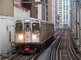
The Chicago "L" is the rapid transit system serving the city of Chicago and some of its surrounding suburbs in the U.S. state of Illinois. Operated by the Chicago Transit Authority (CTA), it is the fourth-largest rapid transit system in the United States in terms of total route length, at 102.8 miles (165.4 km) long as of 2014, and the third-busiest rapid transit system in the United States. In 2016, the "L" had 1,492 rail cars, eight different routes, and 145 train stations. In 2023, the system had 117,447,000 rides, or about 373,800 per weekday in the fourth quarter of 2023.

The Blue Line is a 26.93-mile-long (43.34 km) Chicago "L" line which extends through The Loop from O'Hare International Airport at the far northwest end of the city, through downtown via the Milwaukee–Dearborn subway and across the West Side to its southwest end at Forest Park, with a total of 33 stations. At about 27 miles, it is the longest line on the Chicago "L" system and second busiest, and one of the longest local subway/elevated lines in the world. It has an average of 64,978 passengers boarding each weekday in 2022.
The Green Line is a rapid transit line in Chicago, Illinois, operated by the Chicago Transit Authority (CTA) as part of the Chicago "L" system. It is the only completely elevated route in the "L" system. All other routes may have various combinations of elevated, subway, street level, or freeway median sections.

The North Loop is a neighborhood in the Central community of Minneapolis.

The Near West Side, one of the 77 community areas of Chicago, is on the West Side, west of the Chicago River and adjacent to the Loop. The Great Chicago Fire of 1871 started on the Near West Side. Waves of immigration shaped the history of the Near West Side of Chicago, including the founding of Hull House, a prominent settlement house. In the 19th century railroads became prominent features. In the mid-20th century, the area saw the development of freeways centered in the Jane Byrne Interchange.

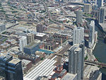
The Richard B. Ogilvie Transportation Center, on the site of the former Chicago and North Western Terminal, is a commuter rail terminal in downtown Chicago, Illinois. For the last century, this site has served as the primary terminal for the Chicago and North Western Railway and its successors Union Pacific and Metra. Intercity services had disappeared by the 1970s, but commuter services on the three ex-CNW mainlines, Metra's UP District lines, continue to terminate here. The tracks are elevated above street level. The old CNW terminal building was replaced in the mid 1980s with a modern skyscraper, the 500 West Madison Street building. The modern building occupies two square city blocks, bounded by Randolph Street and Madison Street to the north and south and by Canal Street and Clinton Street to the east and west. It is the second busiest rail station in Chicago, after nearby Union Station, the sixth-busiest railway station in North America, and the third-busiest station that exclusively serves commuter traffic.

The Chicago Pedway is a network of tunnels, ground-level concourses and bridges in Chicago, Illinois connecting skyscrapers, retail stores, hotels, and train stations throughout the central business district.

LaSalle Street is a major north-south street in Chicago named for René-Robert Cavelier, Sieur de La Salle, a 17th century French explorer of the Illinois Country. The portion that runs through the Chicago Loop is considered to be Chicago's financial district.

Halsted Street is a major north-south street in the U.S. city of Chicago, Illinois.
The Chicago Central Area Transit Plan, generally referred to as the Chicago Central Area Transit Project (CCATP) in the 1970s, was an extensive study of the rapid transit system in downtown Chicago; the study had begun in 1965.

95th/Dan Ryan, announced as 95th, is an 'L' station in the median of the Dan Ryan Expressway and serving Chicago's Roseland neighborhood. It serves as the southern terminus of the Chicago Transit Authority's Red Line. This station was the system's thirteenth busiest in 2021. Trains take approximately 30 minutes to travel to the Loop, and 60 minutes to reach Howard.

Clinton is a station on the Chicago Transit Authority's 'L' system, serving the Green Line and Pink Line. It opened on October 16, 1909, and was completely rebuilt during the Green Line rehabilitation project in 1996.

Pulaski is an 'L' station on the CTA's Orange Line, which runs between Midway Airport and The Loop; it is situated between Midway and Kedzie stations. Pulaski is located at Pulaski Road and 51st Street on the Southwest Side of Chicago, Illinois. The station is within the Archer Heights neighborhood, which is both residential and commercial, and the station itself is in a commercial district on Pulaski Road. Pulaski opened on October 31, 1993, the opening date of the Orange Line.
Rosemont, formerly River Road, is a Chicago "L" station at the intersection of River Road and I-190 in the suburb of Rosemont, Illinois. It is located in the median of I-190 with one island platform serving two tracks, 16 miles (26 km) northwest of The Loop. Trains are scheduled to depart from Rosemont every 2–7 minutes during rush-hour periods, and take about 36 minutes to travel to the Loop. The station is 7 blocks east and 2 blocks north of O'Hare International Airport. Rosemont is the busiest station outside the city limits of Chicago, with 2,090,977 passenger entries in 2014.
Cumberland is a station on the Chicago Transit Authority's 'L' system. Situated on the Blue Line between Rosemont and Harlem, the station is located in the median of the Kennedy Expressway at Cumberland Avenue in the O'Hare community area on Chicago's Northwest Side. It is also in close proximity to both the Norwood Park neighborhood and the city of Park Ridge as well as the village of Norridge. The area surrounding the station consists of mixed commercial and residential development.

The Loop is the 1.79-mile (2.88 km) long circuit of elevated rail that forms the hub of the Chicago "L" system in the United States. As of 2022, the branch served 31,893 passengers every weekday. The Loop is so named because the elevated tracks loop around a rectangle formed by Lake Street, Wabash Avenue (east), Van Buren Street (south), and Wells Street (west). The railway loop has given its name to Chicago's downtown, which is also known as the Loop.
Central Station is a residential development project in the South Loop section of Chicago, Illinois. Originally planned as a 69 acres (28 ha) development, it was later expanded to 72 acres (29 ha), and is now 80 acres (32 ha). Being planned by the city government, it encompasses the former rail yards and air space rights east of Michigan Avenue between Roosevelt Road and 18th Street.

The Jefferson Park Transit Center is an intermodal passenger transport hub in the Jefferson Park neighborhood of Chicago, Illinois. It serves as a station for rail and also as a bus terminal. Jefferson Park Transit Center's railroad station is on Metra's Union Pacific Northwest Line, with the station located at 4963 North Milwaukee Avenue. Jefferson Park is 9.1 miles (14.6 km) away from Ogilvie Transportation Center in downtown Chicago, the inbound terminus of the Union Pacific Northwest Line. Under Metra's zone-based fare system, Jefferson Park is in zone 2. As of 2018, Jefferson Park is the 97th busiest of Metra's 236 non-downtown stations, with an average of 510 weekday boardings.

Wells Street is a major north–south street in Chicago. It is officially designated as 200 West, and is named in honor of William Wells, a United States Army Captain who died in the Battle of Fort Dearborn. Between 1870 and 1912, it was named 5th Avenue so as not to tarnish the name of Wells during a period when the street had a bad reputation.