Michigan Avenue is a north-south street in Chicago which runs at 100 east on the Chicago grid. The northern end of the street is at Lake Shore Drive on the shore of Lake Michigan in the Gold Coast Historic District. The street's southern terminus is at Sibley Boulevard in the southern suburb of Harvey, though like many Chicago streets it exists in several disjointed segments.

Bernard Ralph Maybeck was an American architect in the Arts and Crafts Movement of the early 20th century. He was an instructor at University of California, Berkeley. Most of his major buildings were in the San Francisco Bay Area.

This is a list of properties and districts in Illinois that are on the National Register of Historic Places. There are over 1,900 in total. Of these, 85 are National Historic Landmarks. There are listings in all of the state's 102 counties.
This National Park Service list is complete through NPS recent listings posted May 20, 2022.

U.S. Route 66 was a United States Numbered Highway in Illinois that connected St. Louis, Missouri, and Chicago, Illinois. The historic Route 66, the Mother Road or Main Street of America, took long distance automobile travelers from Chicago to Southern California. The highway had previously been Illinois Route 4 (IL 4) and the road has now been largely replaced with Interstate 55 (I-55). Parts of the road still carry traffic and six separate portions of the roadbed have been listed on the National Register of Historic Places.
Mount Morris Park Historic District was designated a historic district by New York City Landmarks Preservation Commission in 1971, and is part of the larger Mount Morris Park neighborhood. It is a large 16-block area in west central Harlem. The boundaries are West 118th and West 124th Streets, Fifth Avenue, and Adam Clayton Powell Jr. Boulevard.
There are more than 350 places listed on the United States National Register of Historic Places in Chicago, Illinois, including 83 historic districts that may include numerous historic buildings, structures, objects and sites. This total is documented in the tables referenced below. Tables of these listings may be found in the following articles:
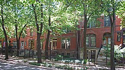
The McCormick Row House District is a group of houses located in the Lincoln Park community area in Chicago, Illinois, USA. It sits between East and West parts of DePaul University's Lincoln Park Campus and is independent from the school. They were built between 1884 and 1889 and used by the McCormick Theological Seminary to gain rental income. They were designed in the Queen Anne Style by the A. M. F. Colton and Son architects and joined the list of Chicago Landmarks May 4, 1971. The McCormick Row House District also lies within the boundaries of the Sheffield Historic District.

The Printing House Row District is a National Historic Landmark District encompassing four architecturally important buildings on the 300 through 500 blocks of South Dearborn, South Federal and South Plymouth streets in the Loop community area of Chicago, Illinois. It was listed on the National Register of Historic Places as South Dearborn Street – Printing House Row Historic District and listed as a National Historic Landmark as South Dearborn Street – Printing House Row North Historic District on January 7, 1976. The district was designated a Chicago Landmark on May 9, 1996. The district includes the Monadnock Building, the Manhattan Building, the Fisher Building, and the Old Colony Building. The district overlaps significantly with the Printers Row neighborhood, and is not the same as South Loop Printing House District.

The Historic Michigan Boulevard District is a historic district in the Loop community area of Chicago in Cook County, Illinois, United States encompassing Michigan Avenue between 11th or Roosevelt Road, depending on the source, and Randolph Streets and named after the nearby Lake Michigan. It was designated a Chicago Landmark on February 27, 2002. The district includes numerous significant buildings on Michigan Avenue facing Grant Park. In addition, this section of Michigan Avenue includes the point recognized as the end of U.S. Route 66. This district is one of the world's best known one-sided streets rivalling Fifth Avenue in New York City and Edinburgh's Princes Street. It lies immediately south of the Michigan–Wacker Historic District and east of the Loop Retail Historic District.

The Thomas H. Gale House, or simply Thomas Gale House, is a house located in the Chicago suburb of Oak Park, Illinois, United States. The house was designed by famous American architect Frank Lloyd Wright in 1892 and is an example of his early work. The house was designed by Wright independently while he was still employed in the architecture firm of Adler & Sullivan, run by engineer Dankmar Adler and architect, Louis Sullivan; taking outside commissions was something that Sullivan forbade. The house is significant because of what it shows about Wright's early development period. The Parker House is listed as contributing property to a U.S. federally Registered Historic District. The house was designated an Oak Park Landmark in 2002.

The Jackson Park Highlands District is a historic district in the South Shore community area of Chicago, Illinois, United States. The district was built in 1905 by various architects. It was designated a Chicago Landmark on October 25, 1989.

The American System-Built Homes were modest houses designed by architect Frank Lloyd Wright. They were developed between 1912 and 1916 to fulfill his interest in affordable housing. Wright was devoted to the idea of providing beautiful yet affordable homes to the public. His firm produced over 960 drawings for the project, the largest number of drawings for any project in the Wright archives. The designs were standardized, and customers could choose from seven models. Because of this standardization, the lumber could be precut at the factory, thereby cutting down on both waste and the amount of skilled labor needed for construction. The buildings are often termed prefabricated homes, but they were not, since no parts of the homes were constructed off-site. The lumber was cut at the factory, packaged along with all other components, and delivered to the work site for construction. Some are located in a federal historic district in Milwaukee, Wisconsin, and others have been designated Chicago Landmarks in Chicago, Illinois.

The Geneseo Historic District, previously known as the Main Street Historic District, is a historic district encompassing much of the village center of Geneseo, New York. Geneseo has a remarkably well-preserved 19th-century streetscape, with Victorian architecture embodying a picturesque style advocated by architect Andrew Jackson Downing. The district was listed on the National Register of Historic Places in 1977; an enlarged district was designated a National Historic Landmark in 1991.

The Warwick Civic Center Historic District is a historic district encompassing three buildings at the civic heart of Warwick, Rhode Island.

The Rochelle Park–Rochelle Heights Historic District is a historic residential district located in the city of New Rochelle in Westchester, New York. The district is historically and architecturally significant as an intact and distinctive example of residential park development at the turn of the Twentieth Century. It includes the historic Rochelle Park development, and the later Rochelle Heights subdivision. Within the district are 555 contributing properties, including 513 buildings, 38 structures, and 4 sites. Only 24 buildings and 1 site separately identified within its area are non-contributing. It was listed on the National Register of Historic Places (NRHP) on July 6, 2005.
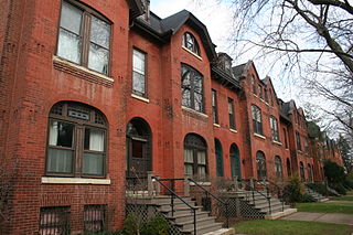
Prairie Avenue is a north–south street on the South Side of Chicago, which historically extended from 16th Street in the Near South Side to the city's southern limits and beyond. The street has a rich history from its origins as a major trail for horseback riders and carriages. During the last three decades of the 19th century, a six-block section of the street served as the residence of many of Chicago's elite families and an additional four-block section was also known for grand homes. The upper six-block section includes part of the historic Prairie Avenue District, which was declared a Chicago Landmark and added to the National Register of Historic Places.
Currently there are 124 properties listed on the National Register of Historic Places in Central Chicago, out of more than 350 listings in the City of Chicago. Central Chicago includes 3 of the 77 well-defined community areas of Chicago: the historic business and cultural center of Chicago known as the Loop, as well as the Near North Side and the Near South Side. The combined area is bounded by Lake Michigan on the east, the Chicago River on the west, North Avenue on the north, and 26th Street on the south. This area runs five and one-quarter miles from north to south and about one and one-half miles from east to west.
There are 68 sites in the National Register of Historic Places listings in West Side, Chicago, out of more than 350 listings in the City of Chicago. The West Side is defined for this article as the area north of the Chicago Sanitary and Ship Canal, south of Fullerton Avenue, west of the Chicago River and east of the western city limits. One site, Logan Square Boulevards Historic District, spans a border and is included also in listings on the North Side. The Chicago Sanitary and Ship Canal Historic District extends through Cook County west of Chicago, DuPage County and Will County to Lockport.

John Crombie Cochrane (1835–1887) was a prominent architect in the 19th century practicing in Chicago, Illinois. He formed Cochrane and Garnsey with George O. Garnsey.
Frost & Granger was an architectural partnership from 1898 to 1910 of brothers-in-law Charles Sumner Frost (1856–1931) and Alfred Hoyt Granger (1867–1939). Frost and Granger were known for their designs of train stations and terminals, including the now-demolished Chicago and North Western Terminal, in Chicago. The firm designed several residences in Hyde Park, Illinois, and many other buildings. Several of their buildings are listed on the U.S. National Register of Historic Places.