
Michigan Avenue is a north-south street in Chicago that runs at 100 east on the Chicago grid. The northern end of the street is at Lake Shore Drive on the shore of Lake Michigan in the Gold Coast Historic District. The street's southern terminus is at Sibley Boulevard in the southern suburb of Dolton, but like many other Chicago streets, it exists in several disjointed segments.

Streeterville is a neighborhood in the Near North Side community area of Chicago, Illinois, United States, north of the Chicago River. It is bounded by the river on the south, the Magnificent Mile portion of Michigan Avenue on the west, and Lake Michigan on the north and east, according to most sources, although the City of Chicago only recognizes a small portion of this region as Streeterville. Thus, it can be described as the Magnificent Mile plus all land east of it. The tourist attraction of Navy Pier and Ohio Street Beach extend out into the lake from southern Streeterville. The majority of the land in this neighborhood is reclaimed sandbar.

Edgewater is a lakefront community area on the North Side of the city of Chicago, Illinois six miles north of the Loop. The most recently established of the city's 77 official community areas, Edgewater is bounded by Foster Avenue on the south, Devon Avenue on the north, Ravenswood Avenue on the west, and Lake Michigan on the east. Edgewater contains several beaches that residents enjoy during the late spring, summer, and early autumn. Chicago's largest park, Lincoln Park, stretches south from Edgewater for seven miles along the waterfront, almost to downtown. Historically, Edgewater was the northeastern corner of Lake View Township, an independent suburb annexed by the city of Chicago in 1889. Today, the Uptown community is to Edgewater's south, Lincoln Square to its west, West Ridge to its northwest and Rogers Park to its north.
Lincoln Park is a 1,208-acre (489-hectare) park along Lake Michigan on the North Side of Chicago, Illinois. Named after US President Abraham Lincoln, it is the city's largest public park and stretches for seven miles (11 km) from Grand Avenue, on the south, to near Ardmore Avenue on the north, just north of the DuSable Lake Shore Drive terminus at Hollywood Avenue. Two museums and a zoo are located in the oldest part of the park between North Avenue and Diversey Parkway in the eponymous neighborhood. Further to the north, the park is characterized by parkland, beaches, recreational areas, nature reserves, and harbors. To the south, there is a more narrow strip of beaches east of Lake Shore Drive, almost to downtown. With 20 million visitors per year, Lincoln Park is the second-most-visited city park in the United States, behind Central Park.

The Near North Side is the eighth of Chicago's 77 community areas. It is the northernmost of the three areas that constitute central Chicago, the others being the Loop and the Near South Side. The community area is located north and east of the Chicago River. To its east is Lake Michigan, and its northern boundary is the early 19th-century city limit of Chicago, North Avenue. In 2020 the Near North Side had 105,481 residents, surpassing Lake View as the largest Chicago community area by population. It is also the most densely populated community area and has the second most skyscrapers, after the Loop. With the exception of Goose Island, the Near North Side is known for its extreme affluence, typified by the Gold Coast, Magnificent Mile, Navy Pier, and skyscrapers.

The Near South Side is a community area of Chicago, Illinois, United States, just south of the downtown central business district, the Loop. The Near South Side's boundaries are as follows: North—Roosevelt Road ; South—26th Street; West—Chicago River between Roosevelt and 18th Street, Clark Street between 18th Street and Cermak Road, Federal between Cermak Road and the Stevenson Expressway just south of 25th Street, and Clark Street again between the Stevenson and 26th Street; and East—Lake Michigan.

Randolph Street is a street in Chicago. It runs east–west through the Chicago Loop, carrying westbound traffic west from Michigan Avenue across the Chicago River on the Randolph Street Bridge, interchanging with the Kennedy Expressway (I-90/I-94), and continuing west. It serves as the northern boundary of Grant Park and the Chicago Landmark Historic Michigan Boulevard District. Several large theaters, as well as city and state government buildings are on and adjacent to Randolph. Metra's Millennium Station is located under Randolph Street.
The Bryn Mawr Historic District is on the lakefront of the Edgewater neighborhood of far-north Chicago, Illinois. It extends along Bryn Mawr Avenue between Broadway and Sheridan Road. Its most prominent features are the Belle Shore Apartment Hotel, Bryn Mawr Apartment Hotel, Edgewater Beach Apartments, Edgewater Presbyterian Church, Manor House, and the northernmost area of Lincoln Park.
Oak Street is a short street in Chicago's Gold Coast neighborhood, adjacent to North Michigan Avenue. Because the street houses the highest concentration of luxury brands, "Oak Street" also designates the surrounding area including Rush Street and Walton Street as Chicago's upscale retail district.

Illinois's 2nd congressional district is a congressional district in the U.S. state of Illinois. Based in the south suburbs of Chicago, the district includes southern Cook county, eastern Will county, and Kankakee county, as well as the city of Chicago's far southeast side.
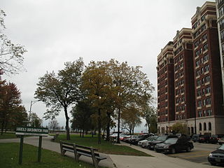
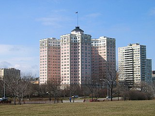
Harold Washington Park is a small park in the Chicago Park District located in the Hyde Park community area on the South Side of Chicago, Illinois, US. In 1992, it was named for Harold Washington (1922–1987), the first African-American Chicago Mayor. The Park District officially calls the park Harold Washington Playlot Park with a designated address of 5200 S. Hyde Park Blvd Chicago, IL 60615. It is one of 4 Chicago Park District parks named after persons surnamed Washington. It is one of 40 Chicago Park District parks named after influential African Americans. The Park is bounded by East 53rd Street on the south, South Hyde Park Boulevard on the west, and Lake Shore Drive to the east. Architecturally, it is flanked to the north by Regents Park and The Hampton House to the south. Its southwest corner opposes two National Register of Historic Places Properties: Hotel Del Prado and East Park Towers.

The Black Metropolis–Bronzeville District is a historic African American district in the Bronzeville neighborhood of the Douglas community area on the South Side of Chicago, Illinois.

The Historic Michigan Boulevard District is a historic district in the Loop community area of Chicago in Cook County, Illinois, United States encompassing Michigan Avenue between 11th or Roosevelt Road, depending on the source, and Randolph Streets and named after the nearby Lake Michigan. It was designated a Chicago Landmark on February 27, 2002. The district includes numerous significant buildings on Michigan Avenue facing Grant Park. In addition, this section of Michigan Avenue includes the point recognized as the end of U.S. Route 66. This district is one of the world's best known one-sided streets rivalling Fifth Avenue in New York City and Edinburgh's Princes Street. It lies immediately south of the Michigan–Wacker Historic District and east of the Loop Retail Historic District.
The Kountze Place neighborhood of Omaha, Nebraska is a historically significant community on the city's north end. Today the neighborhood is home to several buildings and homes listed on the National Register of Historic Places. It is located between North 16th Avenue on the east to North 30th Street on the west; Locust Street on the south to Pratt Street on the north. Kountze Place was annexed into Omaha in 1887. The neighborhood was built as a suburban middle and upper middle class enclave for doctors, lawyers, successful businessmen and other professional workers.

The Astor Street District is a historic district in Central Chicago, Illinois.
The Jackson Park Highlands District is a historic district in the South Shore community area of Chicago, Illinois, United States. The district was built in 1905 by various architects. It was designated a Chicago Landmark on October 25, 1989.

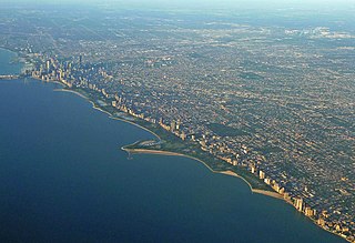
The Gold Coast Historic District is a historic district in Chicago, Illinois. Part of Chicago's Near North Side community area, it is roughly bounded by North Avenue, Lake Shore Drive, Oak Street, and Clark Street.

Indian Village Is the nickname given to the southeast portion of the Kenwood community area of Chicago, Illinois, United States. It is roughly bounded by Lake Shore Drive to the east Burnham Park to the north, 51st Street to the south, Harold Washington Park to the southeast, and the Illinois Central Railroad tracks used by the Metra's South Shore and Metra Electric Lines to the West. Many of the buildings in the neighborhood are named after Native American Indian tribes including the National Register of Historic Places-designated (NRHP) Narragansett and the Chicago Landmark Powhatan Apartments. Other buildings include several Algonquin Apartment buildings and the Chippewa.

Printers Row, also known as Printing House Row, is a neighborhood located in the south of the Chicago downtown area known as the Loop. The heart of Printers Row is generally defined by Ida B. Wells Drive on the north, Polk Street on the south, Plymouth Court on the east, and the Chicago River on the west. This neighborhood overlaps significantly with the officially designated landmark Printing House Row District to the north of Ida B Wells Drive and the South Loop Printing House District to the south of the Drive. The neighborhood includes Dearborn Station, which is also on the National Register of Historic Places.
 Historic District from Oak Street Beach
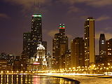 Night on the Gold Coast (including East Lake Shore Drive District to left)
 The East Lake Shore Drive Historic District is a prominent part of the skyline


