South Chicago, Chicago

Last updated

South Chicago
Community Area 46 - South Chicago
20160220 65 Baltimore Ave. @ 92nd St (29452649336).jpg
Baltimore Avenue at 92nd Street
US-IL-Chicago-CA46.svg
Location within the city of Chicago
Coordinates: 41°44.4′N87°33′W / 41.7400°N 87.550°W / 41.7400; -87.550
CountryUnited States
StateIllinois
County Cook
CityChicago
Neighborhoods
list
  • South Shore
Area
  Total3.34 sq mi (8.65 km2)
Population
 (2020)
  Total27,300
  Density8,200/sq mi (3,200/km2)
Demographics 2020 [1]
   White 2.9%
  Black75.3%
  Hispanic20.6%
  Asian0.4%
  Other0.9%
Time zone UTC-6 (CST)
  Summer (DST) UTC-5 (CDT)
ZIP codes
parts of 60617
Median household income $28,504 [1]
Source: U.S. Census, Record Information Services - see Discussion page

South Chicago, formerly known as Ainsworth, is one of the 77 community areas of Chicago, Illinois.

Contents

This chevron-shaped community is one of Chicago's 16 lakefront neighborhoods near the southern rim of Lake Michigan 10 miles south of downtown. A working-class neighborhood, it is bordered by East 79th Street on the north, South Chicago Avenue (the Chicago Skyway) on the southwest, a small stretch of East 95th Street on the south. With the Calumet River on the community's southeast side, South Chicago can be considered the gateway to the Calumet Region and the one of the four Chicago neighborhoods (East Side, Hegewisch and South Deering) that are considered by the locals as part of Chicago's Southeast Side. The Southeast Side is a description that the city itself continues to resist, including this neighborhood with all of Chicago's South Side communities.

History

Once a separate community, South Chicago began as a series of scattered Native American settlements before becoming a village. First occupied by a chief named Askhum, considered 'lord' of the vast Callimink (Calumet) Valley and leader of the Pottawatomie people. They and other Native peoples used South Chicago and the shallow Calumet River area as portages, for seasonal settlements, hunting and fishing thousands of years before White settlers arrived to the "New World".

The post-Civil War era brought with it great industrial innovation. Developer James H. Bowen, the "Father of South Chicago," and others in a massive land grab wrested the land from its former existence and founded "Ainsworth" among other communities. This community was formed out of wetland prairie to provide residence for the labor force of European immigrants coming to work at the industries developing along the Calumet River, most notably the North Chicago Rolling Mill Company, built at the mouth of the river in 1881. Only fractions of the original topography and habitat remain as is the case with most of urban Chicago. With the entire Chicago Lakefront built on miles of landfill and slag there still remains a small stretch of semi-secluded beachfront just north of the Southworks Site. This bit of lakefront, once a seasonal settlement for the Pottawatomie, was left alone due to an unmovable and deeply embedded bedrock of granite, which defied the development techniques of the time. It is the only natural beach frontage left and virtually unknown on the entire Chicago coastline. This beachfront and the massive outcrop of the Southworks table slag to the south and the water treatment plant to the north is a perfect demonstration of the vigorous advancement of the steel industry and 20th-century development.

The four communities of Ainsworth; the Bush, Millgate Cheltenham/South Chicago and Calumet quickly developed into one village referred to collectively as South Chicago during the wave of annexation in 1883. The predominantly woodframed architecture of the Bush, Millgate and eastern Cheltenham are a lesson in Victoriana with the 'sunken yards' and bridge-like walk ups from street like Houston, Baltimore and Brandon attesting to the degree infrastructure built up from the original topography of that time. It also demonstrates how South Chicago was not immediately affected by the housing ordinances restricting the use of lumber for home building after The Great Fire of 1871. Most of the neighborhood north of East 83rd Street and west of South Manistee Avenue was developed after WWII and contain mostly brick homes, but under the ordinance brick homes began being built throughout the newly annexed neighborhood after 1883.

South Chicago was bustling with waves of immigrants as the popularity of the World's Columbian Exposition of 1893. The steel mill became U.S. Steel South Works in 1901, continuing to attract immigrants from Ireland, Eastern Europe, Scandinavia and Italy. During the 1950s many residents called the northeast section of South Chicago *"The Bush" and worked in the local massive steel mill, US Steel. Others worked in neighboring steel mills such as Youngstown Steel, Republic Steel, Bethlehem Steel, and LaSalle Steel. At its zenith, South Chicago helped make the Chicago metropolitan area the leading producer of steel products in the nation. The Willis Tower and the Hancock Building were built from South Chicago steel. [2] The embers, (graphite) from the smokestacks would cause the cars and sidewalks to sparkle and created a golden glow throughout the night. Softball and bowling were popular pastimes. Large Polish weddings on Saturdays were also a common sight.

Throughout the early 1910s, Mexicans from a variety of regions within Mexico began to settle in communities throughout Chicago including South Chicago. South Chicago became one of the first growing Mexican communities in Chicago. The community faced many challenges including many racist attacks by the more assimilated groups. The early Mexican community began to band together and worked to help build Our Lady of Guadalupe Church as they were not welcomed in other churches throughout the area. South Chicago's Mexican Patriotic Club's Mexican Independence Day (Sept. 16th) Parade was the first such parade in Chicago also celebrated with a carnival of rides and booths.

Historical population
CensusPop.Note
1930 56,683
1940 55,090−2.8%
1950 55,7151.1%
1960 49,913−10.4%
1970 45,655−8.5%
1980 46,4221.7%
1990 40,465−12.8%
2000 38,596−4.6%
2010 31,198−19.2%
2020 27,300−12.5%
[1] [3]

Current life

While South Chicago has a sizable African American population, existing ethnic groups continue to have strong community ties in the area. Our Lady of Guadalupe is the oldest parish founded by Mexicans in the City of Chicago. Immaculate Conception, St. Michael's, two churches built in the 'Polish Cathedral style' and later Saint Bronislava have served South Chicago's Polish residents for over 80 years and now have significant sized Latino populations as well. The first Catholic parish established in South Chicago was St. Patrick, which was founded by Irish Catholics.

Much of the business and shopping is done along Commercial Avenue. Several privately owned businesses such as clothing stores, furniture and retail, and beauty salons, can be found along Commercial Avenue. Restaurants from Nigerian to Italian cuisine are found in South Chicago. Despite the slow economy, more "Mom and Pop" stores flourish throughout South Chicago's residential areas, than in any other neighborhood. East 83rd Street, East 87th Street and south along Commercial Avenue to East 95th Street have attracted corporations, businesses and new banks into the community. Commercial Avenue is also home to many non-profit organizations including Healthy South Chicago, the Alianza Leadership Institute, Centro Comunitario Juan Diego, El Valor, Centro de Trabajadores Unidos, and SEDCOM.

The violent crime rate is 401% higher than the national average, according to the latest data from 2020. [4]

Parks and infrastructure

Wedged between East 89th Street, South Muskegon Avenue and the sycamore tree-lined South Chicago Avenue is the historic triangular Bessemer Park, named after English inventor Henry Bessemer, whose iron ore refining process revolutionized steel production. The park was designed by the Olmsted Brothers of the renowned landscape architect Frederick Law Olmsted of New York City's Central Park, as well as Chicago landmarks Washington Park and Jackson Park, built for the World's Columbian Exposition of 1891. Their work on the park started in early 1904 and finished late in 1905. The fieldhouse, only modestly upgraded, retains much of its original charm. The Bessemer Park Nature and Wildlife Garden is among Chicago's 23 noted natural "preserves" of native fauna and wildlife habitat. Bessemer Park and Russell Square Park on the corner of Bond Avenue and East 83rd Street (*the Bush), are among their last commissions, Bessemer Park is one of the largest parks on the South Side. Eckersall Playground Park and Stadium is centrally located in South Chicago at the corner of East 83rd Street and South Yates Avenue. Other new greenspaces are planned throughout the community including what is currently called "Park No. 503" at 8900 South Green Bay Avenue in the Millgate community. Designated bicycle paths from East 83rd Street, South Shore Drive/Mackinaw Avenue and South Chicago Avenue connect directly to the Burnham Greenway Trail which links to a comprehensive system of greenways throughout the Calumet Region.

salt pile between South Harbor Avenue and the Calumet River South Chicago salt pile.JPG
salt pile between South Harbor Avenue and the Calumet River

Since the de-industrialization of South Chicago's once inaccessible shoreline from the late 1970s on, East 87th Street has been extended to Lake Michigan with the look and feel of a landscaped boulevard. The former Southworks site brownfield, an area larger than the Loop, is a cleared and remediated table of slag and concrete, currently being transformed into Chicago's newest lakefront park with the feel of wide open prairie land. The purchase of the property from notable world-class developers, has put South Chicago at the center of the city's, and the Nation's largest lakefront redevelopment effort in the 21st century. Mixed residential, retail and lake recreation are quietly planned. The new lakefront park, as yet nameless (which is nearing completion), was the missing link effectively closing the century-old gap between Chicago's world-class chain of parks between South Shore's Rainbow Beach Park in South Shore and Calumet Park in East Side neighborhoods, fulfilled the dreams of noted Chicago planner and architect, Daniel Burnham and business mogul and philanthropist Montgomery Ward (both of the Gilded Age), for a free and clear lakefront. Famed architect Frank Lloyd Wright had also once designed a comprehensive plan for the shoreline before it became hyper-industrialized.

Transportation

Until 1971, long-distance passenger trains stopped at the Baltimore and Ohio Railroad's South Chicago Station (19 miles from Grand Central Station). Trains included the Chesapeake and Ohio's trains to Grand Rapids, Michigan, and in earlier years, the Resort Special to Bay View. [5] [6] B&O trains included the Capitol Limited and the Washington–Chicago Express. [7] The last B&O trains stopped serving the station between 1968 and 1970.

South Chicago is not connected to the Chicago "L" rapid transit system. The nearest CTA Red Line station is located 3 miles west, at 95th Street & Dan Ryan Expressway. The CTA Green Line is 5 miles north, at 63rd Street and Cottage Grove Avenue. The South Chicago neighborhood does, however, contain 4 newly rebuilt Metra Electric Line, South Chicago Branch stations: Cheltenham and East 79th Street, East 83rd Street, 87th Street, and 93rd Street/South Chicago, which terminates in the heart of the neighborhood's business district along South Baltimore Avenue, and is the community's most accessible commuter rail service to downtown Chicago. Although Metra is mainly a suburban service, the outbound South Chicago Branch, which terminates within Chicago's city limits is the only Metra line to do so. The Chicago Skyway borders South Chicago Avenue, running northwest towards the Dan Ryan Expressway and southeast towards Hammond, Indiana. It can be entered nearby only towards Indiana, but has one westbound entrance, to the southeast at Indianapolis Boulevard & Avenue B.

South Chicago is also served by a number of Chicago Transit Authority bus routes, services which enable commuters to make relatively easy connections to downtown and other Chicago neighborhoods. The buses that serve South Chicago are:

Future

As part of an effort to stimulate sustainable and equitable economic development in the South Chicago neighborhood, the City of Chicago is sponsoring its redevelopment. The effort represents one of the largest sustainable neighborhood revitalization developments in the country and should serve as a guide to the city for sustainable redevelopment on the south side for the next 25 years. [8]

Chicago's plan is to be rated by the United States Green Building Council and is part of the council's LEED (Leadership in Energy and Environmental Design) for Neighborhood Development pilot program. [9]

US Steel South Works Site redevelopment

A thirty-year development plan estimated to cost $4 billion was approved by the city in September 2010, for the former site of the huge steel mill, which operated along the neighborhood's shoreline from 1880 to 1992. [2] The site has undergone extensive demolition and environmental remediation since 1992. The plan called for extension of Lake Shore Drive, with site construction and was to begin in 2012.

Politics

South Chicago is a stronghold for the Democratic Party. In the 2016 presidential election, South Chicago cast 9,908 votes for Hillary Clinton and cast 258 votes Donald Trump. It was Clinton's 22nd largest margin of victory by percentage points in the 76 community areas she won. [10] In the 2012 presidential election, South Chicago cast 12,147 votes for Barack Obama and 207 votes for Mitt Romney. It was Obama's 22nd largest margin of victory by percentage points in the 76 community areas he won. [11]

At the local level, South Chicago is located in Chicago's 7th and 10th wards represented by Democrats Gregory Mitchell and Susie Sadlowski Garza respectively. [12] [13]

Education

Chicago Public Schools operates public schools.

The Roman Catholic Archdiocese of Chicago operates Catholic Schools. St. Michael the Archangel School in South Chicago closed in 2018, when it had 80 students. [14]

Notable people

See also

Related Research Articles

<span class="mw-page-title-main">Rogers Park, Chicago</span> Community area in the United States

Rogers Park is the first of Chicago's 77 community areas. Located 9 miles (14 km) from the Loop, it is on the city's far north side on the shore of Lake Michigan. The neighborhood is commonly known for its cultural diversity, lush green public spaces, early 20th century architecture, live theater, unique bars/restaurants, beaches, and progressive mindset. It is bounded by the city of Evanston along Juneway Terrace and Howard Street to the north, Ridge Boulevard to the west, Devon Avenue and the Edgewater neighborhood to the south, and Lake Michigan to the east. The neighborhood just to the west, West Ridge, was part of Rogers Park until the 1890s and is still commonly referred to as West Rogers Park.

<span class="mw-page-title-main">Lake Shore Drive</span> Lake-side expressway in Chicago, Illinois, United States

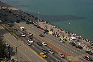
Lake Shore Drive is an expressway that runs alongside the shoreline of Lake Michigan, and adjacent to parkland and beaches, in Chicago. Except for the portion north of Foster Avenue, Lake Shore Drive is designated as part of U.S. Highway 41. A portion of the expressway on the Outer Drive Bridge and its bridge approaches is multilevel.

<span class="mw-page-title-main">Edgewater, Chicago</span> Community area in Chicago

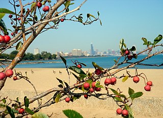
Edgewater is a lakefront community area on the North Side of the city of Chicago, Illinois six miles north of the Loop. The most recently established of the city's 77 official community areas, Edgewater is bounded by Foster Avenue on the south, Devon Avenue on the north, Ravenswood Avenue on the west, and Lake Michigan on the east. Edgewater contains several beaches that residents enjoy during the late spring, summer, and early autumn. Chicago's largest park, Lincoln Park, stretches south from Edgewater for seven miles along the waterfront, almost to downtown. Historically, Edgewater was the northeastern corner of Lake View Township, an independent suburb annexed by the city of Chicago in 1889. Today, the Uptown community is to Edgewater's south, Lincoln Square to its west, West Ridge to its northwest and Rogers Park to its north.

<span class="mw-page-title-main">South Shore, Chicago</span> Community area in Chicago

South Shore is one of 77 defined community areas of Chicago, Illinois, United States. Located on the city's South Side, the area is named for its location along the city's southern lakefront. Although South Shore has seen a greater than 40% decrease in residents since Chicago's population peaked in the 1950s, the area remains one of the most densely populated neighborhoods on the South Side. The community benefits from its location along the waterfront, its accessibility to Lake Shore Drive, and its proximity to major institutions and attractions such as the University of Chicago, the Museum of Science and Industry, and Jackson Park.

<span class="mw-page-title-main">Parks in Chicago</span>

Parks in Chicago include open spaces and facilities, developed and managed by the Chicago Park District. The City of Chicago devotes 8.5% of its total land acreage to parkland, which ranked it 13th among high-density population cities in the United States in 2012. Since the 1830s, the official motto of Chicago has been Urbs in horto, Latin for "City in a garden" for its commitment to parkland. In addition to serving residents, a number of these parks also double as tourist destinations, most notably Lincoln Park, Chicago's largest park, visited by over 20 million people each year, is one of the most visited parks in the United States. Notable architects, artists and landscape architects have contributed to the 570 parks, including Daniel Burnham, Frederick Law Olmsted, Jens Jensen, Dwight Perkins, Frank Gehry, and Lorado Taft.

<span class="mw-page-title-main">Near South Side, Chicago</span> Community area in Chicago

The Near South Side is a community area of Chicago, Illinois, United States, just south of the downtown central business district, the Loop. The Near South Side's boundaries are as follows: North—Roosevelt Road ; South—26th Street; West—Chicago River between Roosevelt and 18th Street, Clark Street between 18th Street and Cermak Road, Federal between Cermak Road and the Stevenson Expressway just south of 25th Street, and Clark Street again between the Stevenson and 26th Street; and East—Lake Michigan.

<span class="mw-page-title-main">West Pullman, Chicago</span> Community area in Chicago

West Pullman is a neighborhood located on the far south side of the city of Chicago, Illinois. It is one of the 77 official community areas of Chicago. The Neighborhood of West Pullman was largely inhabited by workers of the Pullman Train Company who were looking to escape the grip of the company town Pullman. The commercial corridor of Kensington/115th Street was one of many Italian communities within Chicago.

<span class="mw-page-title-main">Calumet Heights, Chicago</span> Community area in Chicago

Calumet Heights, located on the South Side of the city, is one of the 77 well defined community areas of Chicago, Illinois. Calumet Heights is bounded by 87th Street on the north, South Chicago Avenue on the east, and railroad lines on the west and south.

<span class="mw-page-title-main">South Deering, Chicago</span> Community area in Chicago

South Deering, located on Chicago's far South Side, is the largest of the 77 official community areas of that city. Primarily an industrial area, a small residential neighborhood exists in the northeast corner and Lake Calumet takes up a large portion of the area. 80% of the community area is zoned as industrial, natural wetlands, or parks. The remaining 20% is zoned for residential and small-scale commercial uses. It is part of the 10th Ward, once under the control of former Richard J. Daley ally Alderman Edward Vrdolyak.

<span class="mw-page-title-main">East Side, Chicago</span> Community area in Chicago

East Side is one of the 77 official community areas of Chicago, Illinois. It is on the far south side of the city, between the Calumet River and the Illinois-Indiana state line, 13 miles (21 km) south of downtown Chicago. The neighborhood has a park on Lake Michigan, Calumet Park, and a forest, Eggers Grove Forest Preserve. The forest preserve has hiking/walking trails, picnic grounds and birdwatching. It is served by U.S. Highway 12, U.S. Highway 20, and U.S. Highway 41.

<span class="mw-page-title-main">Riverdale, Chicago</span> Community area in Chicago

Riverdale is one of the 77 official community areas of Chicago, Illinois and is located on the city's far south side.

<span class="mw-page-title-main">Hegewisch, Chicago</span> Community area in Chicago

Hegewisch is one of the 77 community areas of Chicago, Illinois, located on the city's far south side. It is bordered by the neighborhoods of Riverdale and South Deering to the west, the East Side to the north, the village of Burnham to the south and the city of Hammond, Indiana to the east. The community area is named for Adolph Hegewisch, the president of U.S. Rolling Stock Company who hoped to establish "an ideal workingman's community" when he laid out the town along a rail line in 1883, six years before Chicago annexed the town.

<span class="mw-page-title-main">Calumet Park</span> United States historic place

Calumet Park is a 198-acre (79-hectare) park in Chicago, Illinois. It provides access to Lake Michigan from the East Side neighborhood on the city's Southeast Side. The park contains approximately 0.9 miles (1.5 km) of lake frontage from 95th Street to 102nd Street. The park is listed on the National Register of Historic Places.

<span class="mw-page-title-main">Illinois's 2nd congressional district</span> U.S. House district for Illinois

Illinois's 2nd congressional district is a congressional district in the U.S. state of Illinois. Based in the south suburbs of Chicago, the district includes southern Cook county, eastern Will county, and Kankakee county, as well as the city of Chicago's far southeast side.

<span class="mw-page-title-main">South Side, Chicago</span> Area of the city of Chicago, Illinois, US

The South Side is one of the three major sections of the city of Chicago, Illinois. Geographically, it is the largest of the three sections of the city, with the other two being the North Side and the West Side. It radiates and lies south of the city's downtown area, the Chicago Loop.

<span class="mw-page-title-main">Miller Beach</span> Neighborhood in Lake County, Indiana, United States

Miller Beach is a neighborhood of Gary, Indiana on the southernmost shore of Lake Michigan. First settled in 1851, Miller Beach was originally an independent town. However, the "Town of Miller" was eventually annexed by the then flourishing city of Gary in 1918. Located in the northeastern corner of Lake County, Indiana, the former town is now known as "The Miller Beach Community." Miller Beach borders Lake Michigan to the north, Porter County to the east, and is largely surrounded by protected lands, including Indiana Dunes National Park. Miller Beach is also the closest beach/resort community to Chicago, and has been a popular vacation spot since the early 20th century. As of the 2000 US census, it had a population of 9,900.

The Daily Calumet was a Chicago newspaper that existed from 1881 until 1987. It was at one time billed as "America's Oldest Daily Community Newspaper."

<span class="mw-page-title-main">Ambridge Mann</span> Neighborhood in Lake County, Indiana, United States

Ambridge Mann, sometimes called Ambridge-Horace Mann or Horace Mann-Ambridge, is a neighborhood in northwestern Gary, Indiana. It is bounded by the Grand Calumet River on the north, by Grant Street on the east, by Chase Street on the west, and by the Norfolk Southern railroad on the south. Adjacent areas include an industrial district to the north, Downtown West to the east, Tolleston to the south, and Brunswick to the west. As of 2000, Ambridge Mann had a population of 6,236, which was 96.3% African-American. Located just south of Interstate 90, the neighborhood can be seen while passing Buchanan Street.

North Harbor is a neighborhood in northeastern East Chicago, Indiana. It constitutes the portion of the Indiana Harbor section north of 138th Street. The neighborhood is home to one of the highest concentrations of affordable housing in the United States.

References

  1. 1 2 3 "Community Data Snapshot - South Chicago" (PDF). cmap.illinois.gov. MetroPulse. Archived (PDF) from the original on December 4, 2017. Retrieved December 3, 2017.
  2. 1 2 Sharoff, Robert (December 28, 2010). "Chicago to Redevelop U.S. Steel Site on Lakefront". The New York Times. Archived from the original on February 26, 2018. Retrieved February 25, 2017.
  3. Paral, Rob. "Chicago Community Areas Historical Data". Archived from the original on March 18, 2013. Retrieved August 30, 2012.
  4. "South Chicago, IL Crime Rates & Map". AreaVibes . Archived from the original on February 14, 2022. Retrieved February 14, 2022.
  5. "Pere Marquette Railway, Tables 1, 6". Official Guide of the Railways. National Railway Publication Company. 74 (1). June 1941.
  6. "Chesapeake and Ohio Railway, Table 10". Official Guide of the Railways. National Railway Publication Company. 96 (1). June 1963.
  7. "Baltimore and Ohio Railroad, Tables 1, 6". Official Guide of the Railways. National Railway Publication Company. 96 (1). June 1963.
  8. "South Chicago LEED Neighborhood Development". GreenBeanChicago.com. Archived from the original on July 20, 2009. Retrieved January 12, 2010.
  9. "Massive new green development planned for abandoned U.S. Steel site". Medill Reports Chicago. Archived from the original on March 23, 2009. Retrieved January 12, 2010.
  10. Ali, Tanveer (November 9, 2016). "How Every Chicago Neighborhood Voted In The 2016 Presidential Election". Chicago, Illinois: DNAinfo.com. Archived from the original on March 17, 2017. Retrieved March 16, 2017.
  11. Ali, Tanveer (November 7, 2012). "How Every Chicago Neighborhood Voted In The 2012 Presidential Election". Chicago, Illinois: DNAinfo.com. Archived from the original on March 17, 2017. Retrieved March 16, 2017.
  12. Connolly, Colleen (February 6, 2015). "Get to Know Your Ward: 7th Ward". Ward Room. WMAQ-TV. Archived from the original on December 27, 2017. Retrieved December 25, 2017.
  13. Connolly, Colleen (February 6, 2015). "Get to Know Your Ward: 10th Ward". Ward Room. WMAQ-TV. Archived from the original on December 27, 2017. Retrieved December 25, 2017.
  14. Hope, Leah; Rob Elgas; Megan Hickey (January 19, 2018). "Archdiocese of Chicago to close 5 Catholic schools". ABC 7 Chicago. Archived from the original on May 8, 2020. Retrieved May 8, 2020.
  15. Yolanda Williams Page (January 2007). Encyclopedia of African American women writers. Greenwood Publishing Group. pp. 43–45. ISBN   978-0-313-33429-0. Archived from the original on May 20, 2016. Retrieved June 2, 2013.
  16. 1 2 3 Simon, Alex (April 23, 2012). "Andrew Davis Returns to Stony Island". Huffington Post . Archived from the original on June 23, 2017. Retrieved December 26, 2017.
  17. Williams, Douglas (April 12, 2016). Baseball's Fallen Angel: A Major Leaguer's Life Story of High Expectations, Hidden Pitfalls, and His Ongoing Fight In Recovery. Conshohocken, Pennsylvania: Infinity Publishing. ISBN   9781495806674.
  18. Kirby, Michael Jack. "Joni James". Way Back Attack. Archived from the original on December 27, 2017. Retrieved December 26, 2017.
  19. Pallasch, Abdon M. (August 26, 2005). "SAMUEL C. MARAGOS 1922-2005; Ex-judge, lawyer worked 'tirelessly' for causes". Chicago Sun-Times . p. 12. Archived from the original on January 2, 2018. Retrieved January 1, 2018 via HighBeam Research.
  20. Zorn, Eric (February 4, 2009). "Bright 'Chicago Eddie' lights day's dark side". Chicago Tribune . Archived from the original on July 3, 2009. Retrieved December 26, 2017.
  21. Lutz, BJ (December 6, 2012). "Despite Arrest, State Senator Still Running to Replace Jesse Jackson Jr". NBC 5 Ward Room. Archived from the original on March 21, 2019. Retrieved March 21, 2019.