Pullman, Chicago

Last updated
Pullman
Community Area 50 - Pullman
Pullman Chicago Clock Tower.jpg
The former Pullman Clock Tower and Administration Building, opened as the Pullman National Monument Visitor Center in September 2021.
US-IL-Chicago-CA50.svg
Location within the city of Chicago
Coordinates: 41°42.6′N87°37.2′W / 41.7100°N 87.6200°W / 41.7100; -87.6200
CountryUnited States
StateIllinois
County Cook
CityChicago
Named for George Pullman
Neighborhoods
list
  • Cottage Grove Heights
  • Pullman
  • Kensington
Area
  Total2.11 sq mi (5.46 km2)
Population
 (2020 [1] )
  Total6,820
  Density3,200/sq mi (1,200/km2)
Demographics 2020 [1]
   White 6.5%
  Black83.6%
  Hispanic7.2%
  Asian0.1%
  Other2.6%
Time zone UTC-6 (CST)
  Summer (DST) UTC-5 (CDT)
ZIP Codes
parts of 60628
Median household income $43,539 [1]
Source: U.S. Census, Record Information Services

Pullman, one of Chicago's 77 defined community areas, is a neighborhood located on the city's South Side. Twelve miles from the Chicago Loop, Pullman is situated adjacent to Lake Calumet.

Contents

The area known as Pullman encompasses a much wider area than its two historic areas (the older historic area is often referred to as "Pullman" and is a Chicago Landmark district and a national historical park. The northern annex historic area is usually referred to as "North Pullman"). The development built by the Pullman Company is bounded by 103rd Street on the North, 115th Street on the South, the railroad tracks on the East and Cottage Grove on the West.

Since the late 20th century, the Pullman neighborhood has been gentrifying. Many residents are involved in the restoration of their own homes, and projects throughout the district as a whole. Walking tours of Pullman are available.

Pullman has many historic and architecturally significant buildings; among these are the Hotel Florence; the Arcade Building, which was destroyed in the 1920s; the Clock Tower and Factory, the complex surrounding Market Square, and Greenstone Church. In the adjacent Kensington neighborhood of the nearby Roseland district is the home of one of the many beautiful churches in Chicago built in Polish Cathedral style, the former church of St. Salomea. It is now used by Salem Baptist Church of Chicago.

In a contest sponsored by the Illinois Department of Commerce and Economic Opportunity, Pullman was one of seven sites nominated for the Illinois Seven Wonders.

History

Beginnings

Historic Pullman was built in the 1880s by George Pullman as workers' housing for employees of his eponymous railroad car company, the Pullman Palace Car Company. He established behavioral standards that workers had to meet to live in the area and charged them rent. Pullman's architect, Solon Spencer Beman, was said to be extremely proud that he had met all the workers' needs within the neighborhood he designed. The distinctive rowhouses were comfortable by standards of the day, and contained such amenities as indoor plumbing, gas, and sewers. [2]

Pullman Strike

Pullman in the late 19th century Greenstone and Arcade Pullman.jpg
Pullman in the late 19th century

During the depression that followed the Panic of 1893, demand for Pullman cars slackened. The Pullman company laid off hundreds of workers and switched many more to pay-per-piece work. This work, while paying more per hour, reduced total worker income. Despite these cutbacks, the Company did not reduce rents for workers who lived in the town of Pullman.

Workers initiated the Pullman Strike in 1894, and it lasted for 2 months, eventually leading to intervention by the US government and military. [3] The Strike Commission, set up in 1894, ruled that the aesthetic features admired by visitors had little monetary value for employees. [4]

Incorporation into Chicago

After George Pullman died in 1897, the Illinois Supreme Court required the company to sell the town because operating it was outside the company's charter. [5] In 1899, the town and other major portions of the South Side were annexed by the city of Chicago. Within ten years, the city sold the houses to their occupants. After the strike, Pullman gradually was absorbed as a regular Chicago neighborhood, defined by distinguishing Victorian architecture. But the fortunes of the neighborhood continued to rise and fall with the Pullman Company for many years.

Deindustrialization

With industrial and railroad restructuring beginning in the 1950s, many jobs were lost in the city. The neighborhood gradually declined along with work opportunities and income. People began to move to newer housing in the suburbs. In 1960 the original Town of Pullman, approximately between 103rd and 115th Streets, was threatened with total demolition for an industrial park. [6] Forming the Pullman Civic Organization, the residents lobbied the city and saved their community. It reached its peak of population in 1970.

Revival

By 1972 the Pullman Historic District had obtained National, State, and City landmark status to protect the original 900 rowhouses and public buildings built by George Pullman. (It was designated a National Historic Landmark District in 1969 and listed on the National Register of Historic Places. In 1970 it was designated as a State landmark by the Illinois Historic Preservation Agency; and in 1972, South Pullman was declared a City of Chicago Landmark). [7] To protect the character of the historic districts, the city has established guidelines for new building and renovation, administered by the City of Chicago. These are explained in the Beman Committee's Homeowner's Guide (the committee is named after Pullman's original architect, Solon Spencer Beman ) [8]

The district was designated the Pullman National Monument under President Obama in February 2015 and redesignated a national historical park in December 2022. [9]

Demographics

Historical population
CensusPop.Note
1930 6,705
1940 6,523−2.7%
1950 8,89936.4%
1960 8,412−5.5%
1970 10,96530.3%
1980 10,341−5.7%
1990 9,344−9.6%
2000 8,921−4.5%
2010 7,325−17.9%
2020 6,820−6.9%
[1] [10]

The Pullman community area is a predominantly African American, older community area, though this is not consistent among each of its neighborhoods. According to a June 2017 analysis by the Chicago Metropolitan Agency for Planning, there were 6,501 people and 2,894 households in Pullman. The racial makeup of the area was 7.1% White, 82.8% African American, 0.5% Asian, 1.1% from other races. Residents who identified as Hispanic or Latino of any race were 8.5% of the population. In the area, the population's age distribution was spread out, with 23.6% under the age of 19, 20.8% from 20 to 34, 19.6% from 35 to 49, 20.2% from 50 to 64, and 15.8% who were 65 years of age or older. The median age was 40 years compared to a citywide figure of 33 years. [1]

The Pullman neighborhood is 29% White, 31% African American, and residents of any race who identify as Hispanic or Latino comprise 36% of the neighborhood's 1,422 residents. [N 1] By contrast, 96% of North Pullman's 1,995 residents are African American and 98% of Cottage Grove Heights' 3,084 residents are African American. [N 2] [N 3]

Media and entertainment

Pullman has been featured in several major motion pictures. Road to Perdition (starring Tom Hanks and Paul Newman) was filmed in historic Pullman, with scenes featuring the factory and how it "once was" with workers, as well as many other scenes of the neighborhood. The 1993 film The Fugitive had several key scenes in Pullman. Harrison Ford was featured in a local bar, next running down an alley, and over the tops of several Pullman rowhouses. In April 2007, Universal Studios filmed The Express: The Ernie Davis Story , which also featured several scenes in Pullman.

The Polar Express animated scenes at the North Pole were based on Pullman architecture. [14] Santa Claus emerges from a building based on the Pullman Company Administration Building; other buildings are based on the architectural style in Pullman. Robert Zemeckis, who designed the movie, grew up in the Roseland neighborhood near Pullman.

On November 12, 2006, Historic Pullman was the topic of the HGTV television show National Open House, which featured a Pullman house at 112th Street and Langley.

Politics

Pullman is a stronghold for the Democratic Party. In the Presidential Election of 2020. Joe Biden carried the Pullman District by a whopping margin (445--21) over Donald Trump, with five votes going to third party candidates. The percentage difference (94.47%--4.46%) mirrored that of the 9th ward, which gave Biden 94.46% of all ballots cast. Only five Wards--Ward 21 (95.83%), Wards 8 and 9 (95.7, apiece), Ward 6 (95.47%), and Ward 7 (94.78%) exceeded this plurality; Ward 5 (94.22%) was 7th highest. Biden carried all 50 Wards in Chicago, by an overall margin of 763,000+ votes (944,735--181,234), a plurality of 66.7% (82.53%--15.83%). He carried Cook County by over 3-to 1, as well (74.35%--24.05%). Indeed, the last Republican candidate to carry the Windy City was Dwight Eisenhower, in 1952-56. In the 2016 presidential election, Pullman cast 3,123 votes for Hillary Clinton and cast 100 votes Donald Trump. Despite winning 94.92% of the vote, it was Clinton's 25th largest share of the vote by percentage in the 76 community areas she won in heavily Democratic Chicago. [15] In the 2012 presidential election, Pullman cast 3,521 votes for Barack Obama and 77 votes for Mitt Romney. Despite winning 97.43% of the vote, it was Obama's 25th largest share of the vote by percentage in the 76 community areas he won in heavily Democratic Chicago. [16]

At the local level, Pullman is located in Chicago's 8th and 9th wards represented by Democratic Alderwoman Michelle Harris and Democratic Alderman Anthony Beale respectively. [17] [18]

Transportation

Pullman is served by two Metra Electric Line stations; Kensington/115th Street station and Pullman/111th Street station. Most Metra suburban express trains passing through the area stop at the 115th Street station, and only local trains stop at the 111th Street station.

Notable people

Education

Corliss High School Corliss HS.jpg
Corliss High School

Pullman is located in City of Chicago School District #299 and City Colleges of Chicago District #508. [22] Pullman is zoned to the following elementary schools; Schmid Elementary School, Wendell Smith Elementary School, Edgar Allan Poe Classical School, and George M. Pullman School. [23] The majority of Pullman is zoned to the Pullman located Corliss High School, while some the northeastern area is zoned to Harlan Community Academy High School in nearby Chatham [24] The main campus of Olive-Harvey College, part of the City Colleges of Chicago system is located in Pullman.

See also

Notes

  1. Census Tract 5003, Cook, IL and Pullman neighborhood are coterminous. [11]
  2. Census Tract 5002, Cook, IL and North Pullman neighborhood are coterminous. [12]
  3. Census Tract 5001, Cook, IL and Cottage Grove Heights are coterminous. [13]

Related Research Articles

<span class="mw-page-title-main">George Pullman</span> American engineer and businessman (1831–1897)

George Mortimer Pullman was an American engineer and industrialist. He designed and manufactured the Pullman sleeping car and founded a company town in Chicago for the workers who manufactured it. This ultimately led to the Pullman Strike due to the high rent prices charged for company housing and low wages paid by the Pullman Company. His Pullman Company also hired African-American men to staff the Pullman cars, known as Pullman porters, who provided elite service and were compensated only in tips.

<span class="mw-page-title-main">Austin, Chicago</span> Community area in Chicago

Austin is one of 77 community areas in Chicago. Located on the city's West Side, it is the third largest community area by population and the second-largest geographically. Austin's eastern boundary is the Belt Railway located just east of Cicero Avenue. Its northernmost border is the Milwaukee District / West Line. Its southernmost border is at Roosevelt Road from the Belt Railway west to Austin Boulevard. The northernmost portion, north of North Avenue, extends west to Harlem Avenue, abutting Elmwood Park. In addition to Elmwood Park, Austin also borders the suburbs of Cicero and Oak Park.

<span class="mw-page-title-main">Hermosa, Chicago</span> Community area in Chicago

Hermosa is one of 77 designated Chicago community areas and is located on the northwest side of Chicago, Illinois. The Hermosa community area contains the Kelvyn Park and Hermosa neighborhoods. The area includes the birthplace of Walt Disney and is the former headquarters of the Schwinn Bicycle Company. While being one of the smaller community areas, Hermosa is one of the city's most densely populated neighborhoods.

<span class="mw-page-title-main">Mount Greenwood, Chicago</span> Community area in Chicago

Mount Greenwood is one of the 77 community areas in Chicago. The 74th numbered area, it is about 14 miles (23 km) southwest of the Loop. It is surrounded by the neighborhoods of Beverly and Morgan Park to the east, the suburb of Evergreen Park to the north, the suburb of Oak Lawn to the west, and the suburbs of Merrionette Park and Alsip to the south. Mount Greenwood is known as the home of many Chicago firefighters, Chicago police officers, and union workers.

<span class="mw-page-title-main">West Pullman, Chicago</span> Community area in Chicago

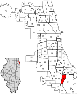
West Pullman is a neighborhood located on the far south side of the city of Chicago, Illinois. It is one of the 77 official community areas of Chicago. The Neighborhood of West Pullman was largely inhabited by workers of the Pullman Train Company who were looking to escape the grip of the company town Pullman. The commercial corridor of Kensington/115th Street was one of many Italian communities within Chicago.

<span class="mw-page-title-main">West Ridge, Chicago</span> Community area in Chicago

West Ridge is one of 77 Chicago community areas. It is a middle-class neighborhood located on the far North Side of the City of Chicago. It is located in the 50th ward and the 40th ward. Also historically called North Town, and frequently referred to as West Rogers Park, it is bordered on the north by Howard Street, on the east by Ridge Boulevard, Western Avenue, and Ravenswood Avenue, the south by Bryn Mawr Avenue and Peterson Avenue, and on the west by Kedzie Avenue and the North Shore channel of the Chicago River. At one time joined with neighboring Rogers Park, it seceded to become its own village in 1890 over a conflict concerning park districts. West Ridge was annexed to Chicago on April 4, 1893, along with Rogers Park.

<span class="mw-page-title-main">Douglas, Chicago</span> Community area in Illinois, United States

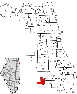
Douglas, on the South Side of Chicago, Illinois, is one of Chicago's 77 community areas. The neighborhood is named for Stephen A. Douglas, Illinois politician and Abraham Lincoln's political foe, whose estate included a tract of land given to the federal government. This tract later was developed for use as the Civil War Union training and prison camp, Camp Douglas, located in what is now the eastern portion of the Douglas neighborhood. Douglas gave that part of his estate at Cottage Grove and 35th to the Old University of Chicago. The Chicago 2016 Olympic bid planned for the Olympic Village to be constructed on a 37-acre (15 ha) truck parking lot, south of McCormick Place, that is mostly in the Douglas community area and partly in the Near South Side.

<span class="mw-page-title-main">Lower West Side, Chicago</span> Community area in Chicago, Illinois, United States

Lower West Side is a community area on the West Side of Chicago, Illinois, United States. It is three miles southwest of the Chicago Loop and its main neighborhood is Pilsen. The Heart of Chicago is a neighborhood in the southwest corner of the Lower West Side.

<span class="mw-page-title-main">Avalon Park, Chicago</span> Community area in Chicago

Avalon Park, located on the south side of the U.S. city of Chicago, Illinois, is one of the city's 77 semi-official community areas and is named after its main park. Its boundaries are 76th St. to the north, South Chicago Ave. to the east and 87th St. to the south. The community area includes the neighborhoods of Avalon Park, Marynook and Stony Island Park.

<span class="mw-page-title-main">Burnside, Chicago</span> Community area in Chicago

Burnside is one of the 77 community areas in Chicago. The 47th numbered area, it is located on the city's far south side. This area is also called "The Triangle" by locals, as it is bordered by railroad tracks on every side; the Canadian National Railway on the west, the Union Pacific Railroad on the south and the Norfolk Southern Railway on the east. With a population of 2,254 in 2016, it is the least populous of the community areas, as well as the second smallest by area after Oakland.

<span class="mw-page-title-main">Calumet Heights, Chicago</span> Community area in Chicago

Calumet Heights, located on the South Side of the city, is one of the 77 well defined community areas of Chicago, Illinois. Calumet Heights is bounded by 87th Street on the north, South Chicago Avenue on the east, and railroad lines on the west and south.

<span class="mw-page-title-main">Roseland, Chicago</span> Community area in Chicago

Roseland is one of the 77 official community areas of Chicago, Illinois, located on the far south side of the city. It includes the neighborhoods of Fernwood, Princeton Park, Lilydale, the southern portion of West Chesterfield, Rosemoor, Sheldon Heights and West Roseland.

<span class="mw-page-title-main">Riverdale, Chicago</span> Community area in Chicago

Riverdale is one of the 77 official community areas of Chicago, Illinois and is located on the city's far south side.

<span class="mw-page-title-main">Hegewisch, Chicago</span> Community area in Chicago

Hegewisch is one of the 77 community areas of Chicago, Illinois, located on the city's far south side. It is bordered by the neighborhoods of Riverdale and South Deering to the west, the East Side to the north, the village of Burnham to the south and the city of Hammond, Indiana to the east. The community area is named for Adolph Hegewisch, the president of U.S. Rolling Stock Company who hoped to establish "an ideal workingman's community" when he laid out the town along a rail line in 1883, six years before Chicago annexed the town.

<span class="mw-page-title-main">O'Hare, Chicago</span> Community area in Chicago

O'Hare, located on the far north side of Chicago, is one of the city's 77 community areas. O'Hare International Airport is located within the boundaries of this community area. This community area is the only one that extends outside Cook County; the western edge is in DuPage County.

<span class="mw-page-title-main">Washington Heights, Chicago</span> Community area in Chicago

Washington Heights is the 73rd of Chicago's 77 community areas. Located 12 miles (19 km) from the Loop, it is on the city's far south side. Washington Heights is considered part of the Blue Island Ridge, along with the nearby community areas of Beverly, Morgan Park and Mount Greenwood, and the village of Blue Island. It contains a neighborhood also known as Washington Heights, as well as the neighborhoods of Brainerd and Fernwood. As of 2017, Washington Heights had 27,453 inhabitants.

<span class="mw-page-title-main">Solon Spencer Beman</span> American architect

Solon Spencer Beman was an American architect based in Chicago, Illinois and best known as the architect of the planned Pullman community and adjacent Pullman Company factory complex, as well as Chicago's renowned Fine Arts Building. Several of his other largest commissions, including the Pullman Office Building, Pabst Building, and Grand Central Station in Chicago, have since been demolished. Beman designed numerous Christian Science churches and influenced the design of countless more.

<span class="mw-page-title-main">Illinois's 2nd congressional district</span> U.S. House district for Illinois

Illinois's 2nd congressional district is a congressional district in the U.S. state of Illinois. Based in the south suburbs of Chicago, the district includes southern Cook county, eastern Will county, and Kankakee county, as well as the city of Chicago's far southeast side.

<span class="mw-page-title-main">Pullman National Historical Park</span> Historic district and national monument in Chicago

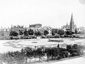
Pullman National Historical Park is a historic district located in Chicago, Illinois, United States, which in the 19th century was the first model, planned industrial community in the United States. The district had its origins in the manufacturing plans and organization of the Pullman Company and became one of the most well-known company towns in the United States, as well as the scene of the violent 1894 Pullman strike. It was built for George Pullman as a place to produce the Pullman railroad-sleeping cars.

<span class="mw-page-title-main">Robert Fioretti</span> American politician

Robert William Fioretti is an American attorney and politician who served as an alderman in the Chicago City Council for the 2nd Ward, which included portions of Bronzeville, East Garfield Park, Illinois Medical District, Little Italy, Loop, Near West Side, Prairie District, South Loop, University Village, Westhaven, and West Loop. Bob first ran for office because of inequities and disinvestments he saw throughout the City of Chicago and communities of the 2nd Ward. He first won election as alderman in 2007 and was re-elected in 2011. He also served as 2nd Ward Democratic Committeeman for two terms, which is a position in the Cook County Democratic Party.

References

  1. 1 2 3 4 5 "Community Data Snapshot – Pullman" (PDF). MetroPulse. Retrieved July 3, 2022.
  2. Newcomen, T. (1998) "Pullman, Illinois: Changes in community planning from the 1880s to the 1990s", International Journal of Heritage Studies, Vol. 4, No. 1, pp. 10-29
  3. Lindsey, A. (1964) The Pullman Strike
  4. United States Strike Commission, The Background to the Dispute: United States Strike Commission Report, Senate Executive Document No. 7, 53rd Congress 3d Session (1894), pp. xxi-xxiii, reprinted in Warne, C. E. (ed.)(1955) The Pullman Boycott of 1894: The Problem of Federal Intervention, D.C. Heath & Co., Boston
  5. Lindsey A. (1964) The Pullman Strike
  6. Reiff, J.L. and Hirsch, S.E. (1989) "Pullman and its public: Image and aim in making and interpreting history", The Public Historian, Vol.11, No. 4 (Autumn), pp. 99-112
  7. Newcomen T. (1998) Pullman, Illinois
  8. The Beman Committee of the Pullman Civic Organisation (n.d.), Homeowner's Guide: Pullman Historic District, Available at http://www.pullmancivic.org/beman/homeownersGuide.pdf
  9. Sheppard, Kate (19 February 2015). "Obama Will Designate 3 New National Monuments". Huffington Post . Retrieved 19 February 2015.
  10. Paral, Rob. "Chicago Community Areas Historical Data". Archived from the original on 18 March 2013. Retrieved 17 September 2012.
  11. "Census Tract 5003, Cook, IL". Census Reporter. Retrieved December 25, 2017.
  12. "Census Tract 5002, Cook, IL". Census Reporter. Retrieved December 25, 2017.
  13. "Census Tract 5001, Cook, IL". Census Reporter. Retrieved December 25, 2017.
  14. Gordon, Alex, Ridin' the reels, Chicago Tribune, October 7, 2007
  15. Ali, Tanveer (November 9, 2016). "How Every Chicago Neighborhood Voted In The 2016 Presidential Election". Chicago, Illinois: DNAinfo.com. Archived from the original on March 17, 2017. Retrieved March 16, 2017.
  16. Ali, Tanveer (November 7, 2012). "How Every Chicago Neighborhood Voted In The 2012 Presidential Election". Chicago, Illinois: DNAinfo.com. Archived from the original on March 17, 2017. Retrieved March 16, 2017.
  17. Sun Times Staff (June 24, 2017). "Dems drop support for Dorothy Brown, endorse Ald. Michelle Harris". Chicago Sun-Times . Retrieved December 25, 2017.
  18. Connolly, Colleen (February 6, 2015). "Get to Know Your Ward: 9th Ward". Ward Room. WMAQ-TV . Retrieved December 25, 2017.
  19. "About Bob Fioretti". Chicago Tribune . February 16, 2015. Retrieved December 25, 2017.
  20. Konkol, Mark (April 16, 2007). "Historic Pullman - Like living in a movie set". Archived from the original on 2011-05-23. Retrieved March 9, 2020.
  21. Johnson, K.C. (December 14, 1997). "Walker Has Reason To Rely On His Survival Skills". Chicago Tribune . Retrieved December 25, 2017.
  22. "Pullman" (Map). City of Chicago. Retrieved on December 19, 2016.
  23. "Near North/West/Central Elementary Schools " (). Chicago Public Schools. Retrieved on December 19, 2016.
  24. "HS Far South." Chicago Public Schools. August 16, 2009. Retrieved on December 19, 2016.

Further reading