Kenwood, one of Chicago's 77 community areas, is on the shore of Lake Michigan on the South Side of the city. Its boundaries are 43rd Street, 51st Street, Cottage Grove Avenue, and the lake. Kenwood was originally part of Hyde Park Township, which was annexed to the city of Chicago in 1889. Kenwood was once one of Chicago's most affluent neighborhoods, and it still has some of the largest single-family homes in the city. It contains two Chicago Landmark districts, Kenwood and North Kenwood. A large part of the southern half of the community area is in the Hyde Park-Kenwood Historic District. In recent years, Kenwood has received national attention as the home of former U.S. President Barack Obama.
Kenwood was settled in the 1850s by wealthy Chicagoans seeking respite from the increasing congestion of the city. The first of these residents was John A. Kennicott, who built his home near the Illinois Central Railroad at 48th Street. He named the home Kenwood after his ancestral land in Scotland, and when the Illinois Central Railroad built a small depot near 47th Street, they named the station Kenwood as well. Shortly afterwards, the name Kenwood began to be applied to the whole area.[2]
The Hyde Park community area is to the south of Kenwood and the southern half of Kenwood (south of 47th Street) is sometimes referred to as Hyde Park-Kenwood.[3]
The public schools in Kenwood are Kenwood Academy, Canter Middle School, King College Prep High School, Ariel Community Academy, William C. Reavis Math and Science Specialty School and Beulah Shoesmith Elementary School. Private Schools in Kenwood include the Ancona Montessori School, Cambridge School of Chicago, Akiba-Schechter Jewish Day School, and Hales Franciscan High School.
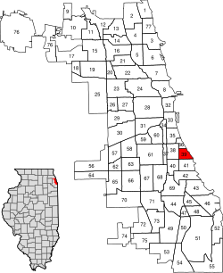
Hyde Park is the 41st of the 77 community areas of Chicago. It is located on the South Side, near the shore of Lake Michigan 7 miles (11 km) south of the Loop.
Jefferson Park is one of the 77 community areas of Chicago, located on the Northwest Side of the city. The neighborhood of Jefferson Park occupies a larger swath of territory.
Gage Park is one of Chicago's 77 well-defined community areas, located on the city's southwest side; it is also the name of a park within the neighborhood. Gage Park's population is largely working-class, and its housing stock is mostly bungalows. For generations, the neighborhood was Eastern European and Irish Catholic. The neighborhood remains overwhelmingly Catholic with the addition of many Hispanic residents. Gage Park is bounded by 49th Street to the north, 59th Street to the south, Central Park Ave to the west, and Leavitt Street to the east.
North Park is one of 77 well-defined community areas of the City of Chicago. It is bordered by the North Shore Channel on the east, the Chicago River's North Branch and Foster Avenue on the south, Cicero Avenue on the west and Devon Avenue on the north.
Archer Heights is a community area in Chicago, Illinois, one of the 77 official community areas of Chicago.
West Lawn, one of Chicago's 77 official community areas, is located on the southwest side of the city. It is considered to be a "melting pot" of sorts, due to its constant change of races moving in and out of the area, as well as the diversity that exists there. It has a small town atmosphere in the big city. West Lawn is home to many Polish-Americans, Irish-Americans, Mexican-Americans, and other people of Latin American and Eastern European origin.
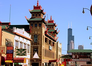
Armour Square is a Chicago neighborhood on the city's South Side, as well as a larger, officially defined community area, which also includes Chinatown and the CHA Wentworth Gardens housing project. Armour Square is bordered by Bridgeport to the west, Pilsen to the northwest, Douglas and Grand Boulevard to the east and southeast, and with the Near South Side bordering the area to the north, and Fuller Park bordering its southernmost boundary, along Pershing Road.
Portage Park is located on the northwest side of the City of Chicago, Illinois and is one of 77 officially designated Chicago community areas. Portage Park is bordered by the community areas of Jefferson Park and Forest Glen to the north, Dunning and the suburb of Harwood Heights to the west, Irving Park to the east and Belmont-Cragin to the south.
West Pullman is a neighborhood located on the far south side of the city of Chicago, Illinois. It is one of the 77 official community areas of Chicago. The Neighborhood of West Pullman was largely inhabited by workers of the Pullman Train Company who were looking to escape the grip of the company town Pullman. The commercial corridor of Kensington/115th Street was one of many Italian communities within Chicago.
West Ridge is one of 77 Chicago community areas. It is a middle-class neighborhood located on the far North Side of the City of Chicago. It is located in the 50th ward and the 40th ward. Also historically called North Town, and frequently referred to as West Rogers Park, it is bordered on the north by Howard Street, on the east by Ridge Boulevard, Western Avenue, and Ravenswood Avenue, the south by Bryn Mawr Avenue and Peterson Avenue, and on the west by Kedzie Avenue and the North Shore channel of the Chicago River. At one time joined with neighboring Rogers Park, it seceded to become its own village in 1890 over a conflict concerning park districts. West Ridge was annexed to Chicago on April 4, 1893, along with Rogers Park.
Brighton Park is a community area located on the southwest side of Chicago, Illinois. It is number 58 of the 77 community areas of Chicago.
Oakland, located on the South Side of Chicago, Illinois, USA, is one of 77 officially designated Chicago community areas. Bordered by 35th and 43rd Streets, Cottage Grove Avenue and Lake Shore Drive, The Oakland area was constructed between 1872 and 1905. Some of Chicago's great old homes may be seen on Drexel Boulevard. The late 19th-century Monument Baptist Church on Oakwood Blvd. is modeled after Boston's Trinity Church. Oakwood /41st Street Beach in Burnham Park is at 4100 S. Lake Shore Drive. With an area of only 0.6 sq mi Oakland is the smallest community area by area in Chicago.
Avalon Park, located on the south side of the U.S. city of Chicago, Illinois, is one of the city's 77 semi-official community areas and is named after its main park. Its boundaries are 76th St. to the north, South Chicago Ave. to the east and 87th St. to the south. The community area includes the neighborhoods of Avalon Park, Marynook and Stony Island Park.
Chatham is one of the 77 community areas of the city of Chicago, Illinois. It is located on the city's South Side. It includes the neighborhoods of Chatham-Avalon, Chatham Club, Chesterfield, East Chatham, West Chatham and the northern portion of West Chesterfield. Its residents are predominantly African American, and it is home to former Senator Roland Burris. Housing many city employees and other officials, Chatham has been a central area for Chicago's middle-class African Americans since the late 1950s.
Calumet Heights, located on the South Side of the city, is one of the 77 well defined community areas of Chicago, Illinois. Calumet Heights is bounded by 87th Street on the north, South Chicago Avenue on the east, and railroad lines on the west and south.
East Side is one of the 77 official community areas of Chicago, Illinois. It is on the far south side of the city, between the Calumet River and the Illinois-Indiana state line, 13 miles (21 km) south of downtown Chicago. The neighborhood has a park on Lake Michigan, Calumet Park, and a forest, Eggers Grove Forest Preserve. The forest preserve has hiking/walking trails, picnic grounds and birdwatching. It is served by U.S. Highway 12, U.S. Highway 20, and U.S. Highway 41.
McKinley Park, one of the 77 official community areas of Chicago, Illinois, is located on the city's southwest side.
Greater Grand Crossing is one of the 77 community areas of Chicago, Illinois. It is located on the city's South Side.
West Elsdon, one of the 77 official community areas, is located on the southwest side of the City of Chicago, Illinois. It is noted as a twin neighborhood of West Lawn. It has a population which includes a mix of dwindling Polish-American residents and increasing Mexican-American residents who currently constitute a clear majority. It has its own association, "West Elsdon Civic Association," which privately organizes the neighborhood. St. Turibius grade school, a Roman Catholic elementary school, located at 57th and Karlov, closed in 2013 and is currently inactive though the building remains and is adjacent to St. Turibius Roman Catholic church. The former Lourdes Roman Catholic girls' high school located from 55th to 56th street from Komensky to Karlov Avenue is now a Chicago Public Schools magnet high school, John Hancock High School.
Clearing, one of the 77 semi-official community areas, is located on the southwest side of the city of Chicago, Illinois. The southern portion of Chicago Midway International Airport is located within this community area.
This page is based on this Wikipedia article Text is available under the CC BY-SA 4.0 license; additional terms may apply. Images, videos and audio are available under their respective licenses.