Auburn Gresham, Chicago

Last updated

Auburn Gresham
Community Area 71 - Auburn Gresham
Auburn Gresham two flats.jpg
Two-flats built in the early 20th century are common in Gresham.
US-IL-Chicago-CA71.svg
Location within the city of Chicago
Coordinates: 41°44.4′N87°39.6′W / 41.7400°N 87.6600°W / 41.7400; -87.6600
CountryUnited States
StateIllinois
County Cook
CityChicago
Neighborhoods
list
Area
  Total3.77 sq mi (9.76 km2)
Population
 (2020) [1]
  Total44,878
  Density12,000/sq mi (4,600/km2)
Demographics (2016-2020) [1]
   White 1.00%
  Black94.5%
  Hispanic3.00%
  Asian0.30%
  Other1.10%
Time zone UTC-6 (CST)
  Summer (DST) UTC-5 (CDT)
ZIP Codes
part of 60620
Median income [1] $37,484
Source: U.S. Census, Record Information Services

Auburn Gresham, most commonly referred to simply as Gresham, is one of the 77 official community areas of the city of Chicago, Illinois. It is located on the far south side of the city and was the original location of the South Side Irish Parade before it was relocated to the adjoining Beverly neighborhood immediately southwest.

Contents

Development

Auburn Gresham's development as a community dates back to the early nineteenth century, when the area was defined primarily by small German and Dutch settlements. A later influx of Irish railroad workers and others lured to the South Side by newly extended city services in the late nineteenth century led to further residential and commercial growth. In the 1920s, the population increased nearly threefold, from 19,558 to 57,381. [2] The plethora of bungalow-style housing and brick two-flat apartment buildings throughout Auburn Gresham serves as lasting evidence of the community's formative years. Like most other Southside communities, Auburn Gresham suffered from blockbusting, rising crime, and white flight during the 1960s: the neighborhood was nearly 100% white in 1960, but flipped to being 69% black by the 1970 census.

St. Sabina Church, dedicated in June 1933, remains a popular place of worship for many Chicagoans. St Sabina Church Chicago 2012.jpg
St. Sabina Church, dedicated in June 1933, remains a popular place of worship for many Chicagoans.

Transportation

Auburn Gresham is serviced by a Metra commuter rail stop at W. 87th St. and Vincennes Ave., which provides daily inbound service to LaSalle Street Station in Chicago and outbound service to Joliet. Community leaders have long encouraged the construction of an additional Metra rail stop at W. 79th St. [3] In 2014, the City of Chicago obtained a half-acre parcel of land on which to construct the station. [4] CTA red line stops at 79th St. and 87th St. are also available along the Dan Ryan Expressway in nearby Chatham.

Landmarks

Chicago Public Library operates the Thurgood Marshall Branch in Auburn Gresham at W. 75th St. and S. Racine Ave. The 13,500 square foot library, which features a 125-seat auditorium, reading garden, and several artworks, opened in April 1994. [5] [6]

St. Sabina Church is located in the community, headed by Rev. Michael Pfleger. The church and its priest have been pivotal in helping transform Auburn Gresham, with new housing and store fronts opening up in the neighborhood. One of the largest new single-family home developments in Chicago is nearly complete at W. 87th St. and S. Parnell Ave., in the southeast corner of Auburn Gresham.

Auburn Gresham is home to the St. Leo Campus for Veterans, which includes the Catholic Charities' St. Leo's Residence, the Auburn Gresham Community Based Outpatient Clinic, the St. Leo's Veteran's Garden, and the Pope John Paul II Residence. [7] The community is also home to Perspectives Leadership Academy and Perspectives Technology Academy which are a part of the Renaissance 2010 program. Both schools are housed in the same building that was home to the former Calumet High School in the Auburn Gresham community. Calumet High School was one of Chicago's oldest high schools opening its doors to Auburn Gresham neighborhood students in 1919. The Auburn Gresham community is also home to the first urban S.O.S. Children's Village in the U.S.

Demographics

Historical population
CensusPop.Note
1920 19,558
1930 57,381193.4%
1940 57,293−0.2%
1950 60,9786.4%
1960 59,484−2.5%
1970 68,85015.7%
1980 65,132−5.4%
1990 59,808−8.2%
2000 55,928−6.5%
2010 48,743−12.8%
2020 44,878−7.9%
[1] [8]

Politics

The Auburn Gresham community area has supported the Democratic Party in the past two presidential elections. In the 2016 presidential election, the Auburn Gresham cast 19,286 votes for Hillary Clinton and cast 272 votes for Donald Trump (97.29% to 1.37%). [9] In the 2012 presidential election, Auburn Gresham cast 24,782 votes for Barack Obama and cast 130 votes for Mitt Romney (99.34% to 0.52%). [10]

Notable people

Related Research Articles

<span class="mw-page-title-main">Jefferson Park, Chicago</span> Community area in Chicago

Jefferson Park is one of the 77 community areas of Chicago, located on the Northwest Side of the city. The neighborhood of Jefferson Park occupies a larger swath of territory.

<span class="mw-page-title-main">Gage Park, Chicago</span> Community area in Chicago

Gage Park is one of Chicago's 77 well-defined community areas, located on the city's southwest side; it is also the name of a park within the neighborhood. Gage Park's population is largely working-class, and its housing stock is mostly bungalows. For generations, the neighborhood was Eastern European and Irish Catholic. The neighborhood remains overwhelmingly Catholic with the addition of many Hispanic residents. Gage Park is bounded by 49th Street to the north, 59th Street to the south, Central Park Ave to the west, and Leavitt Street to the east.

<span class="mw-page-title-main">Archer Heights, Chicago</span> Community area in Chicago

Archer Heights is a community area in Chicago, Illinois, one of the 77 official community areas of Chicago.

<span class="mw-page-title-main">Belmont Cragin, Chicago</span> Community area in Chicago

Belmont Cragin is one of 77 officially designated Chicago community areas located on the Northwest Side of the City of Chicago, Illinois. It is designated Community Area 19, and is located 8 miles (13 km) NW of the Loop.

<span class="mw-page-title-main">Forest Glen, Chicago</span> Community area in Chicago

Forest Glen is one of the 77 official city community areas of Chicago, Illinois, located on the city's Northwest Side. It comprises the neighborhoods of Forest Glen, Edgebrook and Sauganash, with sub-neighborhoods of Sauganash Park, Wildwood, North Edgebrook and Old Edgebrook.

<span class="mw-page-title-main">West Lawn, Chicago</span> Community area in Chicago

West Lawn, one of Chicago's 77 official community areas, is located on the southwest side of the city. It is considered to be a "melting pot" of sorts, due to its constant change of races moving in and out of the area, as well as the diversity that exists there. It has a small town atmosphere in the big city. West Lawn is home to many Polish-Americans, Irish-Americans, Mexican-Americans, and other people of Latin American and Eastern European origin.

<span class="mw-page-title-main">Armour Square, Chicago</span> Community area in Illinois, United States

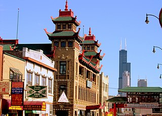
Armour Square is a Chicago neighborhood on the city's South Side, as well as a larger, officially defined community area, which also includes Chinatown and the CHA Wentworth Gardens housing project. Armour Square is bordered by Bridgeport to the west, Pilsen to the northwest, Douglas and Grand Boulevard to the east and southeast, and with the Near South Side bordering the area to the north, and Fuller Park bordering its southernmost boundary, along Pershing Road.

<span class="mw-page-title-main">West Pullman, Chicago</span> Community area in Chicago

West Pullman is a neighborhood located on the far south side of the city of Chicago, Illinois. It is one of the 77 official community areas of Chicago. The Neighborhood of West Pullman was largely inhabited by workers of the Pullman Train Company who were looking to escape the grip of the company town Pullman. The commercial corridor of Kensington/115th Street was one of many Italian communities within Chicago.

<span class="mw-page-title-main">Douglas, Chicago</span> Community area in Illinois, United States

Douglas, on the South Side of Chicago, Illinois, is one of Chicago's 77 community areas. The neighborhood is named for Stephen A. Douglas, Illinois politician and Abraham Lincoln's political foe, whose estate included a tract of land given to the federal government. This tract later was developed for use as the Civil War Union training and prison camp, Camp Douglas, located in what is now the eastern portion of the Douglas neighborhood. Douglas gave that part of his estate at Cottage Grove and 35th to the Old University of Chicago. The Chicago 2016 Olympic bid planned for the Olympic Village to be constructed on a 37-acre (15 ha) truck parking lot, south of McCormick Place, that is mostly in the Douglas community area and partly in the Near South Side.

<span class="mw-page-title-main">Brighton Park, Chicago</span> Community area in Chicago

Brighton Park is a community area located on the southwest side of Chicago, Illinois. It is number 58 of the 77 community areas of Chicago.

<span class="mw-page-title-main">Avalon Park, Chicago</span> Community area in Chicago

Avalon Park, located on the south side of the U.S. city of Chicago, Illinois, is one of the city's 77 semi-official community areas and is named after its main park. Its boundaries are 76th St. to the north, South Chicago Ave. to the east and 87th St. to the south. The community area includes the neighborhoods of Avalon Park, Marynook and Stony Island Park.

<span class="mw-page-title-main">Chatham, Chicago</span> Community area in Chicago

Chatham is one of the 77 community areas of the city of Chicago, Illinois. It is located on the city's South Side. It includes the neighborhoods of Chatham-Avalon, Chatham Club, Chesterfield, East Chatham, West Chatham and the northern portion of West Chesterfield. Its residents are predominantly African American, and it is home to former Senator Roland Burris. Housing many city employees and other officials, Chatham has been a central area for Chicago's middle-class African Americans since the late 1950s.

<span class="mw-page-title-main">South Chicago, Chicago</span> Community area in Chicago

South Chicago, formerly known as Ainsworth, is one of the 77 community areas of Chicago, Illinois.

<span class="mw-page-title-main">Burnside, Chicago</span> Community area in Chicago

Burnside is one of the 77 community areas in Chicago. The 47th numbered area, it is located on the city's far south side. This area is also called "The Triangle" by locals, as it is bordered by railroad tracks on every side; the Canadian National Railway on the west, the Union Pacific Railroad on the south and the Norfolk Southern Railway on the east. With a population of 2,254 in 2016, it is the least populous of the community areas, as well as the second smallest by area after Oakland.

<span class="mw-page-title-main">Calumet Heights, Chicago</span> Community area in Chicago

Calumet Heights, located on the South Side of the city, is one of the 77 well defined community areas of Chicago, Illinois. Calumet Heights is bounded by 87th Street on the north, South Chicago Avenue on the east, and railroad lines on the west and south.

<span class="mw-page-title-main">Roseland, Chicago</span> Community area in Chicago

Roseland is one of the 77 official community areas of Chicago, Illinois, located on the far south side of the city. It includes the neighborhoods of Fernwood, Princeton Park, Lilydale, the southern portion of West Chesterfield, Rosemoor, Sheldon Heights and West Roseland.

<span class="mw-page-title-main">South Deering, Chicago</span> Community area in Chicago

South Deering, located on Chicago's far South Side, is the largest of the 77 official community areas of that city. Primarily an industrial area, a small residential neighborhood exists in the northeast corner and Lake Calumet takes up a large portion of the area. 80% of the community area is zoned as industrial, natural wetlands, or parks. The remaining 20% is zoned for residential and small-scale commercial uses. It is part of the 10th Ward, once under the control of former Richard J. Daley ally Alderman Edward Vrdolyak.

<span class="mw-page-title-main">East Side, Chicago</span> Community area in Chicago

East Side is one of the 77 official community areas of Chicago, Illinois. It is on the far south side of the city, between the Calumet River and the Illinois-Indiana state line, 13 miles (21 km) south of downtown Chicago. The neighborhood has a park on Lake Michigan, Calumet Park, and a forest, Eggers Grove Forest Preserve. The forest preserve has hiking/walking trails, picnic grounds and birdwatching. It is served by U.S. Highway 12, U.S. Highway 20, and U.S. Highway 41.

<span class="mw-page-title-main">Riverdale, Chicago</span> Community area in Chicago

Riverdale is one of the 77 official community areas of Chicago, Illinois and is located on the city's far south side.

<span class="mw-page-title-main">Clearing, Chicago</span> Community area in Chicago

Clearing, one of the 77 semi-official community areas, is located on the southwest side of the city of Chicago, Illinois. The southern portion of Chicago Midway International Airport is located within this community area.

References

  1. 1 2 3 4 "Community Data Snapshot - Auburn Gresham" (PDF). MetroPulse. Retrieved September 27, 2022.
  2. "Auburn Gresham". Encyclopedia of Chicago. 2005. Retrieved August 5, 2012.
  3. "Funding keeps Metra in neutral". Chicago Tribune. December 30, 2009. Retrieved August 5, 2012.
  4. "City of Chicago :: Land Acquisition Will Support New "Auburn Park" Metra Station". Cityofchicago.org. Retrieved November 23, 2016.
  5. "Thurgood Marshall". Chicago Public Library. 2012. Archived from the original on August 14, 2012. Retrieved August 5, 2012.
  6. "Library Does Justice To A Memory". Chicago Tribune. July 22, 1994. Retrieved August 7, 2012.
  7. "St. Leo Campus for Veterans". The Catholic Charities. Retrieved August 10, 2012.
  8. Paral, Rob. "Chicago Community Areas Historical Data". Archived from the original on March 18, 2013. Retrieved September 3, 2012.
  9. Ali, Tanveer (November 9, 2016). "How Every Chicago Neighborhood Voted In The 2016 Presidential Election". DNAInfo . Archived from the original on September 24, 2019. Retrieved October 4, 2019.
  10. Ali, Tanveer (November 9, 2012). "How Every Chicago Neighborhood Voted In The 2012 Presidential Election". DNAInfo . Archived from the original on February 3, 2019. Retrieved October 4, 2019.
  11. Dever, Tim, ed. (September 2007). "Sweet Home Cook County" (PDF). Cook County Clerk. p. 26. Archived from the original (PDF) on May 28, 2016. Retrieved October 2, 2018.
  12. "Michael Flatley Sr., Founder of Flatley's Plumbing Express, Has Passed Away". Patch.com. March 14, 2015. Retrieved October 12, 2017.
  13. Garmes, Kyle (January 22, 2019). "Lyle, 98, earned honors with Tuskegee Airmen". The Beverly Review. Retrieved June 29, 2020.
  14. Sweet, Lynn (June 24, 1998). "White House maintains strong Chicago ties". Chicago Sun-Times via NewsBank.