Hyde Park is a neighborhood and community area on the South Side of Chicago, Illinois, U.S.A. It is located on the shore of Lake Michigan seven miles (11 km) south of the Chicago Loop.
There are more than 350 places listed on the United States National Register of Historic Places in Chicago, Illinois, including 83 historic districts that may include numerous historic buildings, structures, objects and sites. This total is documented in the tables referenced below. Tables of these listings may be found in the following articles:

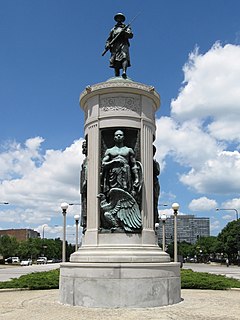
Black Metropolis–Bronzeville District is a historic district in the Bronzeville neighborhood of South Side, Chicago, Illinois.
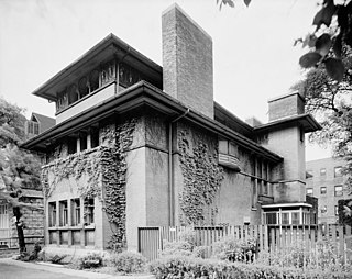
The Isidore H. Heller House is a house located at 5132 South Woodlawn Avenue in the Hyde Park community area of Chicago in Cook County, Illinois, United States. The house was designed by American architect Frank Lloyd Wright. The design is credited as one of the turning points in Wright's shift to geometric, Prairie School architecture, which is defined by horizontal lines, flat or hipped roofs with broad overhanging eaves, windows grouped in horizontal bands, and an integration with the landscape, which is meant to evoke native Prairie surroundings.

The Printing House Row District is a National Historic Landmark District encompassing four architecturally important buildings on the 300 through 500 blocks of South Dearborn, South Federal and South Plymouth streets in the Loop community area of Chicago, Illinois. It was listed on the National Register of Historic Places as South Dearborn Street – Printing House Row Historic District and listed as a National Historic Landmark as South Dearborn Street – Printing House Row North Historic District on January 7, 1976. The district was designated a Chicago Landmark on May 9, 1996. The district includes the Monadnock Building, the Manhattan Building, the Fisher Building, and the Old Colony Building. The district overlaps significantly with the Printers Row neighborhood, and is not the same as South Loop Printing House District.
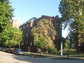
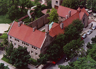
The Frank R. Lillie House is a historic house at 5801 South Kenwood Avenue, on the campus of the University of Chicago on the South Side of Chicago, Illinois. Built in 1904 to a design by Pond and Pond, it was home for many years to Frank R. Lillie (1870–1947), a pioneering embryologist and influential supporter of the Woods Hole Oceanographic Institute. Designated a National Historic Landmark in 1976, it is now used by the university as office space.

The Villa District, also known as Villa Historic District, is a historic district in Chicago, Illinois, United States. It is located on Chicago's Northwest Side within the community area of Irving Park. Its borders are along Pulaski Road to the west, the Union Pacific/Northwest rail line to the north, Hamlin Avenue to the east, and Addison Street to the south. Located directly north of the Wacławowo area of Avondale, the Villa District is serviced by the Blue Line's Addison street station.

The Michigan–Wacker Historic District is a National Register of Historic Places District that includes parts of the Chicago Loop and Near North Side community areas in Chicago, Illinois, United States. The district is known for the Chicago River, two bridges that cross it, and eleven high rise and skyscraper buildings erected in the 1920s. Among the contributing properties are the following Chicago Landmark structures:

Indian Village Is the nickname given to the southeast portion of the Kenwood community area of Chicago, Illinois, United States. It is roughly bounded by Lake Shore Drive to the east Burnham Park to the north, 51st Street to the south, Harold Washington Park to the southeast, and the Illinois Central Railroad tracks used by the Metra's South Shore and Metra Electric Lines to the West. Many of the buildings in the neighborhood are named after Native American Indian tribes including the National Register of Historic Places-designated (NRHP) Narragansett and the Chicago Landmark Powhatan Apartments. Other buildings include several Algonquin Apartment buildings and the Chippewa.
Kenwood Historic District may refer to:
Prairie Avenue is a north–south street on the South Side of Chicago, which historically extended from 16th Street in the Near South Side community area of Chicago in Cook County, Illinois, United States, to the city's southern limits and beyond. The street has a rich history from its origins as a major trail for horseback riders and carriages. During the last three decades of the 19th century, a six-block section of the street served as the residence of many of Chicago's elite families and an additional four-block section was also known for grand homes. The upper six-block section includes part of the historic Prairie Avenue District, which was declared a Chicago Landmark and added to the National Register of Historic Places.
Currently there are 124 National Register of Historic Places listings in Central Chicago, out of 374 listings in the City of Chicago. Central Chicago includes 3 of the 77 well-defined community areas of Chicago: the historic business and cultural center of Chicago known as the Loop, as well as the Near North Side and the Near South Side. The combined area is bounded by Lake Michigan on the east, the Chicago River on the west, North Avenue on the north, and 26th Street on the south. This area runs five and one-quarter miles from north to south and about one and one-half miles from east to west.
There are 67 sites in the National Register of Historic Places listings in West Side, Chicago, out of more than 350 listings in the City of Chicago. The West Side is defined for this article as the area north of the Chicago Sanitary and Ship Canal, south of Fullerton Avenue, west of the Chicago River and east of the western city limits. One site, Logan Square Boulevards Historic District, spans a border and is included also in listings on the North Side. The Chicago Sanitary and Ship Canal Historic District extends through Cook County west of Chicago, DuPage County and Will County to Lockport.
There are 94 sites on the National Register of Historic Places listings in South Side Chicago — of more than 350 total listings within the City of Chicago, in Cook County, Illinois.
There are 94 sites in the National Register of Historic Places listings in North Side Chicago — of 374 listings within the City of Chicago, in Cook County, Illinois.
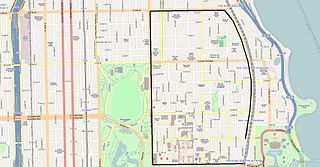
Hyde Park–Kenwood Historic District is the name of the National Register of Historic Places (NRHP) district on the South Side of Chicago that includes parts of the Hyde Park and Kenwood community areas of Chicago, Illinois. The northern part of this district overlaps with the officially designated Chicago Landmark Kenwood District. This northern part of the Hyde Park–Kenwood Historic District contains the Chicago home of Barack Obama. The entire district was added to the NRHP on February 14, 1979 and expanded on August 16, 1984 and May 16, 1986. The district is bounded to the north, south, east and west, respectively by 47th Street, 59th Street, Lake Park Avenue and Cottage Groves Avenue. Despite the large amount of property associated with the University of Chicago, the Hyde Park–Kenwood Historic District is mostly residential. The district is considered to be significant for its architecture and education.