The Bryn Mawr Historic District is on the lakefront of the Edgewater neighborhood of far-north Chicago, Illinois. It extends along Bryn Mawr Avenue between Broadway Avenue and Sheridan Road. Its most prominent features are the Belle Shore Apartment Hotel, Bryn Mawr Apartment Hotel, Edgewater Beach Apartments, Edgewater Presbyterian Church, Manor House, and the northernmost area of Lincoln Park.

The Belle Shore Apartment Hotel is a building of the Bryn Mawr Historic District in the far-north community area of Edgewater in Chicago, Illinois. Located on West Bryn Mawr Avenue, it is across the road from the Bryn Mawr Apartment Hotel. It was declared a historic Chicago Landmark by the Chicago City Council.

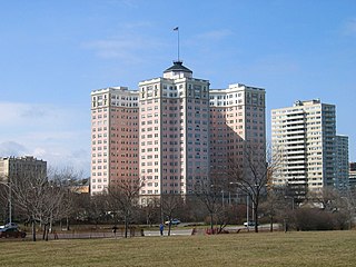
The Bryn Mawr Apartment Hotel is a 12-story building in the Bryn Mawr Historic District in far-north neighborhood community of Edgewater in Chicago, Illinois. Located on North Kenmore Avenue, it is across the road from the Belle Shore Apartment Hotel. It was designated a historic Chicago Landmark by the Chicago City Council on November 6, 2002.

LaSalle Street is a major north-south street in Chicago named for Robert de La Salle, an early explorer of Illinois. The portion that runs through the Chicago Loop is considered to be Chicago's financial district.

Lincoln Avenue is a street of the north side of city of Chicago. It runs from Clark Street on the western border of Lincoln Park largely to the northwest, ending in Morton Grove, Illinois. It leaves the city limits of Chicago at Devon Avenue, through the village of Lincolnwood, curves through the village of Skokie and ends at Dempster Street in Morton Grove. In total distance it is about 13 miles (21 km) long, although it is not completely continuous. Between Foster Avenue and Skokie Boulevard U.S. Route 41 runs on Lincoln Avenue.
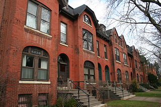
The McCormick Row House District is a group of houses located in the Lincoln Park community area in Chicago, Illinois, USA. It sits between East and West parts of DePaul University's Lincoln Park Campus and is independent from the school. They were built between 1884 and 1889 and used by the McCormick Theological Seminary to gain rental income. They were designed in the Queen Anne Style by the A. M. F. Colton and Son architects and joined the list of Chicago Landmarks May 4, 1971. The McCormick Row House District also lies within the boundaries of the Sheffield Historic District.

Black Metropolis–Bronzeville District is a historic district in the Bronzeville neighborhood of South Side, Chicago, Illinois.

The Kenwood District is a historic district in the officially designated Kenwood community area of Chicago, Illinois bounded by E. 47th and E. 51st Streets, S. Blackstone and S. Drexel Avenues. It was designated a Chicago Landmark on June 29, 1979. The official community areas were defined in the early 20th century and the current meaning of the Hyde Park neighborhood includes the area between 47th Street and 51st Street as a part of Hyde Park, although this area is officially the south half of the official Kenwood neighborhood. The region is part of the Hyde Park-Kenwood Historic District.

The Wicker Park District is a historic district in the West Town community area of Chicago, Illinois. It is the neighborhood bounded by Bell Avenue, Caton Street, Leavitt Street, Potomac Avenue and Chicago 'L' tracks. It was designated a Chicago Landmark on April 12, 1991.

The Chicago Avenue Pumping Station is a historic district contributing property in the Old Chicago Water Tower District landmark district. It is located on Michigan Avenue along the Magnificent Mile shopping district in the Near North Side community area of Chicago, Illinois. It is on the east side of Michigan Avenue opposite the Chicago Water Tower.

The Armitage-Halsted District is a historic district in the Lincoln Park community area of Chicago, Illinois, United States. The district was built between 1870 and 1930 by various architects. It was designated a Chicago Landmark on February 5, 2003.

The Astor Street District is a historic district in Central Chicago, Illinois.

The Jewelers Row District is a historic district in the Loop community area of Chicago, Illinois in the United States. Running along Wabash Avenue, primarily between East Washington Street and East Monroe Street, the buildings in the district were built between 1872 and 1941 and were designed by many architects, including Graham, Anderson, Probst & White, John Mills Van Osdel, Adler & Sullivan, Alfred Alschuler, D. H. Burnham & Co., and Holabird & Roche in a variety of styles, including Italianate, Chicago School, and Art Deco. The buildings are variously loft buildings used for small manufacturers, mercantile buildings, office buildings and early skyscrapers.

The Brewster Apartments is a residential building in the Lake View neighborhood of Chicago. Located at Diversey and Park, it was designed by the architect Enock Hill Turnock for Norwegian native, Bjoerne Edwards, publisher of American Contractor, with construction starting in 1893. Edwards would die from an 8-floor fall at the construction site before the project was completed. The building was designated a Chicago Landmark on October 6, 1982.

Abraham Lincoln: The Man is a larger-than-life size bronze statue of Abraham Lincoln, the 16th president of the United States. The original statue is in Lincoln Park in Chicago, and several replicas have been installed in other places around the world. Completed by Augustus Saint-Gaudens in 1887, it has been described as the most important sculpture of Lincoln from the 19th century. At the time, the New York Evening Post called it "the most important achievement American sculpture has yet produced." Abraham Lincoln II, Lincoln's only grandson, was present, among a crowd of 10,000, at the unveiling. The artist later created the Seated Lincoln sculpture in Chicago's Grant Park.

Mannheim Road, also known as La Grange Road from Cermak Road to U.S. Route 30, is a north–south major street in the near-western suburbs of Chicago. It carries U.S. Routes 12 from Des Plaines to 95th St near Hickory Hills, 45 between Des Plaines on southwards past Frankfort, Illinois and carries U.S. Route 20 between Lake Street in Stone Park, Illinois and 95th St. near Hickory Hills, Illinois The road is named after a former town called Mannheim, Illinois that was founded by German farmers in what is now Franklin Park, Illinois. From Cermak Road on the Westchester/La Grange Park border and points to the south, it is known as La Grange Road. Mannheim Road skirts the eastern edge of O'Hare International Airport; numerous airport hotels and rental car services are located on the street near the airport. One major landmark of Mannheim Road is the Allstate Arena at the intersection of Mannheim Road and Lunt Avenue in Rosemont. There is also a Metra station on the Milwaukee West Line at Mannheim Road; in addition, Metra's BNSF Railway Line has a stop on La Grange Road in La Grange. Also, there is an overpass that carries Mannheim Rd over the Union Pacific rail yard. Also there is another overpass that carries the street over the Canadian Pacific railroad yard. At the descent of that overpass the road goes under the Tri-State Tollway. There's also a school district on the left side of the street named Mannheim School District 83 on the intersection of Grand Avenue and Mannheim Road itself in Franklin Park. North Avenue also dips under Mannheim Road in Melrose Park.

Loop Retail Historic District is a shopping district within the Chicago Loop community area in Cook County, Illinois, United States. It is bounded by Lake Street to the north, Ida B. Wells Drive to the south, State Street to the west and Wabash Avenue to the east. The district has the highest density of National Historic Landmark, National Register of Historic Places and Chicago Landmark designated buildings in Chicago. It hosts several historic buildings including former department store flagship locations Marshall Field and Company Building, and the Sullivan Center. It was added to the National Register of Historic Places on November 27, 1998. It includes 74 contributing buildings and structures, including 13 separately listed Registered Historic Places, and 22 non-contributing buildings. Other significant buildings in the district include the Joffrey Tower, Chicago Theatre, Palmer House, and Page Brothers Building. It also hosts DePaul University's College of Commerce, which includes the Kellstadt Graduate School of Business and the Robert Morris College.

The Milwaukee-Diversey-Kimball District is an official City of Chicago Landmark District straddling the Chicago community areas of Avondale and Logan Square at the gateway to the Polish Village. This district includes 7 buildings in the vicinity of the intersection of Milwaukee Avenue, Kimball Avenue, and Diversey Parkway.


