The Global Positioning System (GPS), originally Navstar GPS, is a satellite-based radio navigation system owned by the United States government and operated by the United States Space Force. It is one of the global navigation satellite systems (GNSS) that provide geolocation and time information to a GPS receiver anywhere on or near the Earth where there is an unobstructed line of sight to four or more GPS satellites. It does not require the user to transmit any data, and operates independently of any telephonic or Internet reception, though these technologies can enhance the usefulness of the GPS positioning information. It provides critical positioning capabilities to military, civil, and commercial users around the world. Although the United States government created, controls and maintains the GPS system, it is freely accessible to anyone with a GPS receiver.
Ultra high frequency (UHF) is the ITU designation for radio frequencies in the range between 300 megahertz (MHz) and 3 gigahertz (GHz), also known as the decimetre band as the wavelengths range from one meter to one tenth of a meter. Radio waves with frequencies above the UHF band fall into the super-high frequency (SHF) or microwave frequency range. Lower frequency signals fall into the VHF or lower bands. UHF radio waves propagate mainly by line of sight; they are blocked by hills and large buildings although the transmission through building walls is strong enough for indoor reception. They are used for television broadcasting, cell phones, satellite communication including GPS, personal radio services including Wi-Fi and Bluetooth, walkie-talkies, cordless phones, satellite phones, and numerous other applications.

The European Geostationary Navigation Overlay Service (EGNOS) is a satellite-based augmentation system (SBAS) developed by the European Space Agency and EUROCONTROL on behalf of the European Commission. Currently, it supplements the GPS by reporting on the reliability and accuracy of their positioning data and sending out corrections. The system will supplement Galileo in a future version.
Globalstar, Inc. is an American satellite communications company that operates a low Earth orbit (LEO) satellite constellation for satellite phone and low-speed data communications. The Globalstar second-generation constellation consists of 25 low Earth orbiting (LEO) satellites.
Integrated Services Digital Broadcasting is a Japanese broadcasting standard for digital television (DTV) and digital radio.
Digital radio is the use of digital technology to transmit or receive across the radio spectrum. Digital transmission by radio waves includes digital broadcasting, and especially digital audio radio services.
The S band is a designation by the Institute of Electrical and Electronics Engineers (IEEE) for a part of the microwave band of the electromagnetic spectrum covering frequencies from 2 to 4 gigahertz (GHz). Thus it crosses the conventional boundary between the UHF and SHF bands at 3.0 GHz. The S band is used by airport surveillance radar for air traffic control, weather radar, surface ship radar, and some communications satellites, especially those satellites used by NASA to communicate with the Space Shuttle and the International Space Station. The 10 cm radar short-band ranges roughly from 1.55 to 5.2 GHz. The S band also contains the 2.4–2.483 GHz ISM band, widely used for low power unlicensed microwave devices such as cordless phones, wireless headphones (Bluetooth), wireless networking (WiFi), garage door openers, keyless vehicle locks, baby monitors as well as for medical diathermy machines and microwave ovens. India's regional satellite navigation network (IRNSS) broadcasts on 2.483778 to 2.500278 GHz.
1worldspace, known for most of its existence simply as WorldSpace, is a defunct satellite radio network that in its heyday provided service to over 170,000 subscribers in eastern, southern and northern Africa, the Middle East, and much of Asia with 96% coming from India. It was profitable in India, with 450,000 subscribers.

A satellite telephone, satellite phone or satphone is a type of mobile phone that connects to other phones or the telephone network by radio link through satellites orbiting the Earth instead of terrestrial cell sites, as cellphones do. Therefore, they can work in most geographic locations on the Earth's surface, as long as open sky and the line-of-sight between the phone and the satellite are provided. Depending on the architecture of a particular system, coverage may include the entire Earth or only specific regions. Satellite phones provide similar functionality to terrestrial mobile telephones; voice calling, text messaging, and low-bandwidth Internet access are supported through most systems. The advantage of a satellite phone is that it can be used in such regions where local terrestrial communication infrastructures, such as landline and cellular networks, are not available.
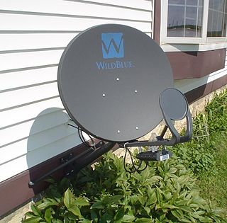
Satellite Internet access or Satellite Broadband is Internet access provided through communication satellites. Modern consumer grade satellite Internet service is typically provided to individual users through geostationary satellites that can offer relatively high data speeds, with newer satellites using Ku band to achieve downstream data speeds up to 506 Mbit/s. In addition, new satellite internet constellations are being developed in low-earth orbit to enable low-latency internet access from space.

The history of mobile phones covers mobile communication devices that connect wirelessly to the public switched telephone network.

A satellite navigation or satnav system is a system that uses satellites to provide autonomous geopositioning. A satellite navigation system with global coverage is termed global navigation satellite system (GNSS). As of 2023, four global systems are operational: the United States's Global Positioning System (GPS), Russia's Global Navigation Satellite System (GLONASS), China's BeiDou Navigation Satellite System, and the European Space Agency's Galileo.
Mobile television is television watched on a small handheld or mobile device, typically developed for that purpose. It includes service delivered via mobile phone networks, received free-to-air via terrestrial television stations, or via satellite broadcast. Regular broadcast standards or special mobile TV transmission formats can be used. Additional features include downloading TV programs and podcasts from the Internet and storing programming for later viewing.

Inmarsat is a British satellite telecommunications company, offering global mobile services. It provides telephone and data services to users worldwide, via portable or mobile terminals which communicate with ground stations through fifteen geostationary telecommunications satellites.
DVB-SH is a physical layer standard for delivering IP based media content and data to handheld terminals such as mobile phones or PDAs, based on a hybrid satellite/terrestrial downlink and for example a GPRS uplink. The DVB Project published the DVB-SH standard in February 2007.
ETSI Satellite Digital Radio describes a standard of satellite digital radio. It is an activity of the European standardisation organisation ETSI.

The Iridium satellite constellation provides L band voice and data information coverage to satellite phones, satellite messenger communication devices and integrated transceivers. Iridium Communications owns and operates the constellation, additionally selling equipment and access to its services. It was conceived by Bary Bertiger, Raymond J. Leopold and Ken Peterson in late 1987 and then developed by Motorola on a fixed-price contract from July 29, 1993, to November 1, 1998, when the system became operational and commercially available.

Ligado Networks, formerly known as LightSquared, is an American satellite communications company.

The European Union Agency for the Space Programme (EUSPA) is a space agency, managing the European Union Space Programme as one of the agencies of the European Union (EU). It was initially created as the European Global Navigation Satellite Systems Supervisory Authority (GSA) in 2004, reorganised into the European Global Navigation Satellite Systems Agency in 2010, and established in its current form on May 12, 2021. EUSPA is a separate entity from the European Space Agency (ESA), although the two entities work together closely.