Suffolk is a ceremonial county in the East of England and East Anglia. It is bordered by Norfolk to the north, the North Sea to the east, Essex to the south, and Cambridgeshire to the west. The largest settlement is Ipswich.

Lowestoft is a coastal town and civil parish in the East Suffolk district of Suffolk, England. As the most easterly UK settlement, it is 110 miles (177 km) north-east of London, 38 miles (61 km) north-east of Ipswich and 22 miles (35 km) south-east of Norwich, and the main town in its district. The estimated population in the built-up area exceeds 70,000. Its development grew with the fishing industry and as a seaside resort with wide sandy beaches. As fishing declined, oil and gas exploitation in the North Sea in the 1960s took over. While these too have declined, Lowestoft is becoming a regional centre of the renewable energy industry.
Ipswich is a port town and borough in Suffolk, England. Of which it is the county town of Suffolk. It is in East Anglia, about 10 miles (16 km) away from the mouth of the River Orwell and the North Sea.

Bury St Edmunds, commonly referred to locally as Bury, is a historic market and cathedral town and civil parish in Suffolk, England. The picturesque Bury St Edmunds Abbey is near the town centre. Bury is the seat of the Diocese of St Edmundsbury and Ipswich of the Church of England, with the episcopal see at St Edmundsbury Cathedral.

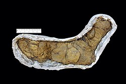
A coprolite is fossilized feces. Coprolites are classified as trace fossils as opposed to body fossils, as they give evidence for the animal's behaviour rather than morphology. The name is derived from the Greek words κόπρος and λίθος. They were first described by William Buckland in 1829. Before this, they were known as "fossil fir cones" and "bezoar stones". They serve a valuable purpose in paleontology because they provide direct evidence of the predation and diet of extinct organisms. Coprolites may range in size from a few millimetres to over 60 centimetres.

Stowmarket is a market town in Suffolk, England, on the busy A14 trunk road between Bury St Edmunds to the west and Ipswich to the southeast. The town is on the main railway line between London and Norwich, and lies on the River Gipping, which is joined by its tributary, the River Rat, to the south of the town.

The East Suffolk line is an un-electrified 49-mile secondary railway line running between Ipswich and Lowestoft in Suffolk, England. The traffic along the route consists of passenger services operated by Greater Anglia, while nuclear flask trains for the Sizewell nuclear power stations are operated by Direct Rail Services.

Ipswich railway station is on the Great Eastern Main Line in the East of England, serving the town of Ipswich, Suffolk. It is 68 miles 59 chains (110.6 km) down the line from London Liverpool Street and, on the main line, it is situated between Manningtree to the south and Needham Market to the north.

Darsham is a village in Suffolk, England. It is located approximately 4 miles (6 km) north east of Saxmundham. The village is bypassed by the A12 and is served by Darsham railway station, which is approximately one mile away from the village centre, on the Ipswich-Lowestoft East Suffolk Line.

Stowmarket railway station is on the Great Eastern Main Line (GEML) in the East of England, serving the town of Stowmarket, Suffolk. It is 80 miles 9 chains (128.9 km) down the line from London Liverpool Street and is situated between Needham Market to the south and Diss to the north. It is also the junction where the Ipswich to Ely Line joins the GEML. Its three-letter station code is SMK.

Suffolk County Council is the administrative authority for the county of Suffolk, England. It is run by 75 elected county councillors representing 63 divisions. It is a member of the East of England Local Government Association.

The Port of Ipswich can be dated to c.625. The name Ipswich was originally Gippeswyc, referring to the River Gyppes with a suffix derived from the Scandinavian term vik, which had evolved from meaning bay or inlet to mean landing-place, following the proliferation of merchants requiring places to unload their goods and conduct trade. Since 1997 the port has been run by Associated British Ports.

Waldringfield is a village and civil parish in the East Suffolk district, in the county of Suffolk, England. It is situated on the bank of the River Deben within the Suffolk Coast and Heaths Area of Outstanding Natural Beauty, 4 miles (6.4 km) south of the town of Woodbridge and 8 miles (12.9 km) east of the county town of Ipswich.

Kirton is a village and a civil parish in the shire county of Suffolk, England, situated off the A14 road, about 4.5 km (2.8 mi) from Felixstowe and around 10 km (6.2 mi) from Ipswich. The closest train station to Kirton is Trimley. According to the 2011 census, Kirton had a population of 1,146. It is located between the River Deben and the River Orwell. The village of Kirton covers a total area of 8.3 km2 (3.2 sq mi). As the county of Suffolk lacks quarries, many of the buildings are made from flint, clay and timber.

The Ipswich Docks, Ipswich wet dock and the wet dock, are a series of docks in Port of Ipswich located at a bend of the River Orwell which has been used for trade since at least the 8th Century. A wet dock was constructed in 1842 which was 'the biggest enclosed dock in the United Kingdom' at the time. A major regeneration of the area has taken place since 1999.
Edward Packard, senior, was an English chemist and businessperson who founded and developed a major artificial fertilizer industry near Ipswich, Suffolk in the mid-nineteenth century, and became a wealthy and prominent figure in the life of the Borough. His son, Sir Edward Packard, junior developed Packard and James Fison (Thetford) Limited ('Fisons') into one of the largest fertiliser manufacturing businesses in the United Kingdom.

East Suffolk and North Essex NHS Foundation Trust is an NHS foundation trust in the East of England. It runs Colchester Hospital in Colchester, Essex and Ipswich Hospital in Ipswich, Suffolk, as well as several smaller community hospitals in the surrounding area.
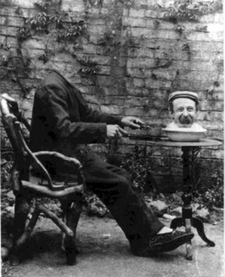
Harry Walters was a prominent photographer in late Victorian and Edwardian Ipswich.

Thomas Patrick Hunt is a British politician who has served as the Member of Parliament (MP) for Ipswich since 2019. He is a member of the Conservative Party.

Duke Street is a street in Ipswich, Suffolk, England, which played an important part in the industrial development of Ipswich. Originally, it was quite short, however, as its modern southern portion was known as St John's Street. Coprolite Street connects it the quay at Neptune Marina, part of Ipswich Waterfront.