
Suffolk is a ceremonial county in the East of England and East Anglia. It is bordered by Norfolk to the north, the North Sea to the east, Essex to the south, and Cambridgeshire to the west. The largest settlement is Ipswich.
Ipswich is a port town and borough in Suffolk, England. Of which it is the county town of Suffolk. It is in East Anglia, about 10 miles (16 km) away from the mouth of the River Orwell and the North Sea.
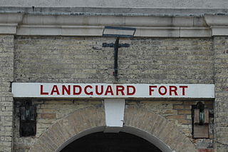
Landguard Fort is a fort at the mouth of the River Orwell outside Felixstowe, Suffolk, designed to guard the mouth of the river. It is now managed by the charity English Heritage and is open to the public.

The Felixstowe branch line is a railway branch line in Suffolk, England, that connects the Great Eastern Main Line to Felixstowe and its port.

Ipswich railway station is on the Great Eastern Main Line in the East of England, serving the town of Ipswich, Suffolk. It is 68 miles 59 chains (110.6 km) down the line from London Liverpool Street and, on the main line, it is situated between Manningtree to the south and Needham Market to the north.
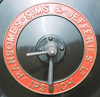
Ransomes, Sims and Jefferies Limited was a major British agricultural machinery maker also producing a wide range of general engineering products in Ipswich, Suffolk including traction engines, trolleybuses, ploughs, lawn mowers, combine harvesters and other tilling equipment. Ransomes also manufactured Direct Current electric motors in a wide range of sizes, and electric forklift trucks and tractors. They manufactured aeroplanes during the First World War. Their base, specially set up in 1845, was named Orwell Works.

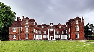
Woolverstone Hall is a large country house, now in use as a school and available at times as a function venue, located 5 miles (8.0 km) south of the centre of Ipswich, Suffolk, England. It is set in 80 acres (320,000 m2) on the banks of the River Orwell. Built in 1776 for William Berners by the architect John Johnson of Leicestershire, it is an outstanding example of English Palladian architecture and is a Grade I listed building while associated buildings are Grade II. From 1951 to 1990, it housed Woolverstone Hall School, a boarding school operated by London County Council (LCC).

Orwell railway station was on the Felixstowe Branch Line near the small village of Nacton, Suffolk, England. It was situated between Derby Road and Trimley stations and was opened in 1877 but was closed in 1959 to allow an acceleration of the service to the remaining stations. The former station building is now a private residence near to the modern Seven Hills crematorium.

The Orwell Bridge is a concrete box girder bridge just south of Ipswich in Suffolk, England. Opened to road traffic in 1982, the bridge carries the A14 road over the River Orwell.

Walton is a settlement and former civil parish, now in the parish of Felixstowe, in the East Suffolk district, in the county of Suffolk, England, lying between the rivers Orwell and Deben. In 1911 the parish had a population of 4226.

The Suffolk and Ipswich Football League is a football competition based in Suffolk, England. The league has a total of eight divisions; the Senior Division and Divisions 1–3 for first teams, three divisions for reserve teams, and Division 4, which is for open to both first teams and reserves and is subordinate to both Division 3 and League C. The Senior Division is at step 7 of the National League System. The league was founded in 1896 as the Ipswich & District League changing its name in 1978.

Stoke Bridge in Ipswich carries Bridge Street (A137) over the point at which the River Gipping becomes the River Orwell. It carries traffic into Ipswich from the suburb of Over Stoke. The bridge consists of two separate structures and is just upstream from Ipswich dock on a tidal section of the river.

The Port of Ipswich can be dated to c.625. The name Ipswich was originally Gippeswyc, referring to the River Gyppes with a suffix derived from the Scandinavian term vik, which had evolved from meaning bay or inlet to mean landing-place, following the proliferation of merchants requiring places to unload their goods and conduct trade. Since 1997 the port has been run by Associated British Ports.

Ransomes & Rapier was a major British manufacturer of railway equipment and later cranes, from 1869 to 1987. Originally an offshoot of the major engineering company Ransome's it was based at Waterside Works in Ipswich, Suffolk.

Ipswich is the county town of Suffolk, England. It is a medieval port and industrial town with a strong transport history; the urban area has a population of 122,000 and currently offers urban transport services for cars, cycles and buses. In addition there are 3 railway stations and regional coach services. London Stansted Airport is accessible by the airlink coach.

The Ipswich Waterfront is a cultural and historically significant area surrounding the marina in the town of Ipswich, Suffolk. The modern dock was constructed in 1842 and the area was a functioning dock up until the 1970s. At the time of completion, the dock was known as 'the biggest and most important enclosed dock in the kingdom'. Although the dock as it stands was constructed in 1842, the area was used for trade as far back as the 7th century. The decline of industry in the town resulted in the area being transformed into a trendy area of Ipswich, the waterfront is now characterised by its marina, known as Neptune Marina, as well as its mix of classical and postmodern architecture which includes multiple high-rise apartment buildings, restaurants, bars and cafés. The waterfront is also home to the main campus of the regions university, the University of Suffolk.

Stoke is a suburb in the Ipswich district, in the county of Suffolk, England. Stoke was placed in the hundred of Ipswich in 1086 in the Domesday Book as one of 470 places under the control of the Abbey of Ely St Etheldreda. Stoke is associated with the coming of the railway, and consequent industrialisation . For election purposes, the part of Stoke nearest Ipswich town centre is referred to as Bridge Ward. The southern part is Stoke Park Ward.

The Ipswich Docks, Ipswich wet dock and the wet dock, are a series of docks in Port of Ipswich located at a bend of the River Orwell which has been used for trade since at least the 8th Century. A wet dock was constructed in 1842 which was 'the biggest enclosed dock in the United Kingdom' at the time. A major regeneration of the area has taken place since 1999.

St Peter's Church is one of the twelve medieval churches in the ancient borough of Ipswich, England. An Augustinian priory dedicated to St Peter and Paul occupied a six-acre site to the north and east of the church. As the secular canons regularly used the chancel for religious purposes, leaving the nave for use of parishioners, the church was also known as St Peter and Paul's. The church is located between College Street and Star Lane, with St Peters Street leading north into Ipswich town centre.

Coprolite Street is a street in Ipswich, Suffolk in the Waterfront area. It runs from Duke Street to Neptune Marina, the former Orwell Quay. It was named after the factory which processed coprolite, or fossilised faeces, near Ipswich Docks. This factory was established by Edward Packard on the site of a former mill in 1849. It is believed by local people to be the only Coprolite Street in the country or even the world, and attracts geologists in particular who like to have their photograph taken by the street sign.


