Corinth, Mississippi

Last updated

Corinth, Mississippi
Landscape Downtown Corinth MS.jpg
Downtown Corinth in 2010
Flag of Corinth, Mississippi.png
Seal of Corinth, Mississippi.png
Alcorn County Mississippi Incorporated and Unincorporated areas Corinth Highlighted.svg
Location of Corinth, Mississippi
USA Mississippi location map.svg
Red pog.svg
Corinth, Mississippi
Location in Mississippi
Usa edcp location map.svg
Red pog.svg
Corinth, Mississippi
Corinth, Mississippi (the United States)
Coordinates: 34°56′14″N88°30′55″W / 34.93722°N 88.51528°W / 34.93722; -88.51528
CountryUnited States
State Mississippi
County Alcorn
Named for Corinth, Greece
Area
[1]
  Total30.29 sq mi (78.44 km2)
  Land30.16 sq mi (78.12 km2)
  Water0.13 sq mi (0.32 km2)
Elevation
440 ft (134 m)
Population
 (2020)
  Total14,622
  Density484.80/sq mi (187.18/km2)
Time zone UTC−6 (Central (CST))
  Summer (DST) UTC−5 (CDT)
ZIP codes
38834–38835
Area code 662
FIPS code 28-15700
GNIS feature ID0668825
Website cityofcorinthms.com

Corinth is a city in and the county seat of Alcorn County, Mississippi, United States. [2] The population was 14,573 at the 2010 census. [3] Its ZIP codes are 38834 and 38835. It lies on the state line with Tennessee.

Contents

History

Work crew repaving Taylor Street, 1930 CorinthMSTaylorStreet.jpg
Work crew repaving Taylor Street, 1930
"Crossroads of the Confederacy" Railroad crossover in Corinth, Mississippi, United States.jpg
"Crossroads of the Confederacy"

Corinth was founded in 1853 as Cross City, so-called because it served as a junction for the Mobile & Ohio and Memphis & Charleston railroads. It was the town's early newspaper editor, W. E. Gibson, who suggested its current name for the city of Corinth in Greece that also served as a crossroads.

Corinth's location at the junction of two railroads made it strategically important to the Confederacy during the American Civil War. Confederate General P. G. T. Beauregard retreated to Corinth after the Battle of Shiloh (April 1862), pursued by Union Major General Henry W. Halleck. General Beauregard abandoned the town on May 29 when General Halleck approached, letting it fall into the Union's hands. Since Halleck had approached so cautiously, digging entrenchments at every stop for over a month, this action has been known as the Siege of Corinth.

The Union sent Maj. Gen. William Rosecrans to Corinth as well and concentrated its forces in the city. The Second Battle of Corinth took place on October 3−4, 1862, when Confederate Maj. Gen. Earl Van Dorn attempted to retake the city. Corinth ultimately became a destination for refugees from slavery called contrabands and was "widely regarded as a 'model' camp." [5]

Inside the Civil War Interpretive Center in Corinth. Inside the Corinth Civil War Interpretive Center.jpg
Inside the Civil War Interpretive Center in Corinth.

Locales on the National Register of Historic Places

Geography

Alcorn County Courthouse and Confederate Memorial Alcorn County Courthouse Mississippi.JPG
Alcorn County Courthouse and Confederate Memorial

Corinth is located in northeast Mississippi at the intersection of (north/south) U.S. Route 45 and (east/west) U.S. Route 72. U.S. 45 runs to the west of the city as a bypass, leading north 19 mi (31 km) to Selmer, Tennessee, and south 21 mi (34 km) to Booneville. U.S. 72 runs through the southern part of the city, leading southeast 14 mi (23 km) to Burnsville and west 23 mi (37 km) to Walnut. It is the county seat of Alcorn County, which is the smallest county by area in the state of Mississippi.

According to the United States Census Bureau, the city has a total area of 30.3 square miles (78.4 km2), of which 30.2 square miles (78.1 km2) is land and 0.12 square miles (0.3 km2), or 0.43%, is water. [6]

Communities near Corinth

Rivers and streams

Climate

The climate is humid subtropical (Köppen: Cfa) like all of Mississippi but with frequent and regular gusts of snow. [7]

Climate data for Corinth, Mississippi (1991–2020 normals, extremes 1895–present)
MonthJanFebMarAprMayJunJulAugSepOctNovDecYear
Record high °F (°C)80
(27)
86
(30)
89
(32)
97
(36)
100
(38)
106
(41)
111
(44)
110
(43)
105
(41)
96
(36)
88
(31)
80
(27)
111
(44)
Mean daily maximum °F (°C)49.2
(9.6)
54.0
(12.2)
63.0
(17.2)
72.6
(22.6)
80.2
(26.8)
86.9
(30.5)
90.0
(32.2)
89.7
(32.1)
84.5
(29.2)
73.7
(23.2)
61.4
(16.3)
52.1
(11.2)
71.4
(21.9)
Daily mean °F (°C)39.8
(4.3)
43.7
(6.5)
51.6
(10.9)
60.5
(15.8)
69.2
(20.7)
76.5
(24.7)
79.9
(26.6)
78.9
(26.1)
72.5
(22.5)
61.0
(16.1)
49.6
(9.8)
42.6
(5.9)
60.5
(15.8)
Mean daily minimum °F (°C)30.4
(−0.9)
33.5
(0.8)
40.1
(4.5)
48.4
(9.1)
58.2
(14.6)
66.0
(18.9)
69.7
(20.9)
68.0
(20.0)
60.5
(15.8)
48.2
(9.0)
37.7
(3.2)
33.2
(0.7)
49.5
(9.7)
Record low °F (°C)−19
(−28)
−6
(−21)
9
(−13)
25
(−4)
35
(2)
43
(6)
51
(11)
47
(8)
33
(1)
21
(−6)
4
(−16)
−6
(−21)
−19
(−28)
Average precipitation inches (mm)4.89
(124)
5.01
(127)
5.42
(138)
5.54
(141)
5.67
(144)
5.02
(128)
4.57
(116)
3.57
(91)
4.12
(105)
4.26
(108)
4.43
(113)
6.32
(161)
58.82
(1,494)
Average snowfall inches (cm)0.4
(1.0)
0.3
(0.76)
0.0
(0.0)
0.0
(0.0)
0.0
(0.0)
0.0
(0.0)
0.0
(0.0)
0.0
(0.0)
0.0
(0.0)
0.0
(0.0)
0.0
(0.0)
0.0
(0.0)
0.7
(1.8)
Average precipitation days (≥ 0.01 in)9.89.010.19.29.48.98.97.45.47.08.010.2103.3
Average snowy days (≥ 0.1 in)0.30.10.10.00.00.00.00.00.00.00.00.00.5
Source: NOAA [8] [9]

Demographics

Historical population
CensusPop.Note
1870 1,512
1880 2,27550.5%
1890 2,111−7.2%
1900 3,66173.4%
1910 5,02037.1%
1920 5,4989.5%
1930 6,22013.1%
1940 7,81825.7%
1950 9,78525.2%
1960 11,45317.0%
1970 11,5811.1%
1980 13,18013.8%
1990 11,820−10.3%
2000 14,05418.9%
2010 14,5733.7%
2020 14,6220.3%
U.S. Decennial Census [10]

2020 census

Corinth Racial Composition [11]
RaceNum.Perc.
White 9,47764.81%
Black or African American 3,57024.42%
Native American 330.23%
Asian 1210.83%
Pacific Islander 100.07%
Other/Mixed 5313.63%
Hispanic or Latino 8806.02%

As of the 2020 United States Census, there were 14,622 people, 6,087 households, and 3,555 families residing in the city.

2000 census

As of the census [12] of 2000, there were 14,054 people, 6,220 households, and 3,800 families residing in the city. The population density was 461.5 people per square mile (178.2 people/km2). There were 7,058 housing units at an average density of 231.8 per square mile (89.5/km2). The racial makeup of the city was 76.28% White, 21.60% African American, 0.09% Native American, 0.36% Asian, 0.12% Pacific Islander, 0.84% from other races, and 0.73% from two or more races. Hispanic or Latino of any race were 1.73% of the population.

There were 6,220 households, out of which 26.0% had children under the age of 18 living with them, 42.9% were married couples living together, 14.8% had a female householder with no husband present, and 38.9% were non-families. Of all households, 35.6% were made up of individuals, and 16.0% had someone living alone who was 65 years of age or older. The average household size was 2.19 and the average family size was 2.82.

In the city, the population was spread out, with 21.8% under the age of 18, 9.3% from 18 to 24, 25.6% from 25 to 44, 23.7% from 45 to 64, and 19.6% who were 65 years of age or older. The median age was 40 years. For every 100 females, there were 85.5 males. For every 100 females age 18 and over, there were 81.0 males.

The median income for a household in the city was $23,436, and the median income for a family was $35,232. Males had a median income of $29,027 versus $21,071 for females. The per capita income for the city was $15,452. About 18.2% of families and 22.2% of the population were below the poverty line, including 26.2% of those under age 18 and 23.9% of those age 65 or over.

Education

Borroum's Drug Store Borroum's Drug Store.jpg
Borroum's Drug Store
Downtown Corinth between Fillmore Street and Cruise Street Corinth,Mississippi Fillmore and Cruise Streets.jpg
Downtown Corinth between Fillmore Street and Cruise Street

Public schools

Corinth School District: [13]

Alcorn School District: [14]

Libraries

Museums

Health care

Transportation

Highways

Air travel

Roscoe Turner Airport [20] is a general aviation airport just outside Corinth. The nearest airports with regularly scheduled commercial service are Tupelo Regional Airport, about 54 miles (87 km) south of Corinth, and Memphis International Airport, about 90 miles (140 km) west of Corinth.

Media

Newspapers

FM and AM radio stations

Notable people

See also

Notes

  1. "2020 U.S. Gazetteer Files". United States Census Bureau. Retrieved July 24, 2022.
  2. "Find a County". National Association of Counties. Archived from the original on May 31, 2011. Retrieved June 7, 2011.
  3. "Corinth (city), Mississippi". U.S. Census Bureau. Archived from the original on January 20, 2016.
  4. McCord's Studio. "'Taylor Street Looking North, Oct. 1930.' Work crew repaving street". Mississippi Department of Archives and History. Archived from the original on April 6, 2012. Retrieved December 2, 2011.
  5. Manning, Chandra (December 19, 2017), "Contraband Camps and the African American Refugee Experience during the Civil War", Oxford Research Encyclopedia of American History, Oxford University Press, doi:10.1093/acrefore/9780199329175.013.203, ISBN   978-0-19-932917-5 , retrieved July 29, 2023
  6. "Geographic Identifiers: 2010 Demographic Profile Data (G001): Corinth city, Mississippi". U.S. Census Bureau, American Factfinder. Archived from the original on February 12, 2020. Retrieved June 18, 2013.
  7. "Corinth climate: Average Temperature, weather by month, Corinth weather averages - Climate-Data.org". en.climate-data.org. Retrieved February 20, 2019.
  8. "NowData - NOAA Online Weather Data". National Oceanic and Atmospheric Administration. Retrieved June 9, 2021.
  9. "Station: Corinth 7 SW, MS". U.S. Climate Normals 2020: U.S. Monthly Climate Normals (1991–2020). National Oceanic and Atmospheric Administration. Retrieved June 9, 2021.
  10. "Census of Population and Housing". Census.gov. Retrieved June 4, 2015.
  11. "Explore Census Data". data.census.gov. Retrieved December 7, 2021.
  12. "U.S. Census website". United States Census Bureau . Retrieved January 31, 2008.
  13. "Corinth School District :: Welcome to Corinth School District" . Retrieved August 22, 2015.
  14. "Alcorn School District". www.alcornschools.org. Retrieved March 29, 2019.
  15. "Alcorn School District ::" . Retrieved August 22, 2015.
  16. "Alcorn School District ::" . Retrieved August 22, 2015.
  17. "Alcorn School District ::" . Retrieved August 22, 2015.
  18. Northeast Mississippi Museum Archived 2005-03-08 at the Wayback Machine
  19. "Corinth" . Retrieved August 22, 2015.
  20. "AirNav: KCRX - Roscoe Turner Airport" . Retrieved August 22, 2015.
  21. 'Illinois Blue Book 1977–1978,' Biographical Sketch of Peggy Smith Martin, pg. 119

Related Research Articles

<span class="mw-page-title-main">Hardin County, Tennessee</span> County in Tennessee, United States

Hardin County is a county located in the U.S. state of Tennessee. As of the 2020 census, the population was 26,831. The county seat is Savannah. Hardin County is located north of and along the borders of Mississippi and Alabama. The county was founded in November 1819 and named posthumously for Col. Joseph Hardin, a Revolutionary War soldier and a legislative representative for the Province of North Carolina; the State of Franklin; and the Southwest Territory. Hardin County was the site of the Battle of Shiloh during the Civil War.

<span class="mw-page-title-main">Alcorn County, Mississippi</span> County in Mississippi, United States

Alcorn County is a county located in the northeastern portion of the U.S. state of Mississippi. As of the 2020 census, the population was 34,740. Its county seat is Corinth. The county is named in honor of Governor James L. Alcorn.

<span class="mw-page-title-main">Marion, Arkansas</span> City in Arkansas, United States

Marion is a city in and the county seat of Crittenden County, Arkansas, United States. The population was 12,345 at the 2010 census, a 38.7% increase since 2000. The city is part of the Memphis metropolitan area. It is the second largest city in Crittenden County, behind West Memphis.

<span class="mw-page-title-main">West Memphis, Arkansas</span> City in Arkansas, United States

West Memphis is the largest city in Crittenden County, Arkansas, United States. The population was 26,245 at the 2010 census, ranking it as the state's 18th largest city, behind Bella Vista. It is part of the Memphis metropolitan area, and is located directly across the Mississippi River from Memphis, Tennessee.

<span class="mw-page-title-main">Blytheville, Arkansas</span> City in Arkansas, United States

Blytheville is the county seat and the largest city in Mississippi County, Arkansas, United States. It is approximately 60 miles (100 km) north of West Memphis. The population was 13,406 at the 2020 census, down from 15,620 in 2010.

<span class="mw-page-title-main">Bellevue, Iowa</span> City in Iowa, United States

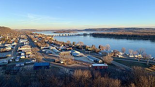
Bellevue is a city in eastern Jackson County, Iowa, United States. The city lies along the Mississippi River and next to Bellevue State Park. In 2020 its population was 2,363; up from a count of 2,191 at the 2010 Census, making it the second-largest and only growing city in Jackson County.

<span class="mw-page-title-main">Farmington, Mississippi</span> Town in Mississippi, United States

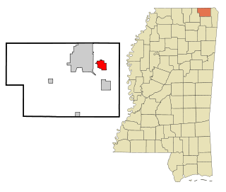
Farmington is a town in Alcorn County, Mississippi. The population was 2,186 at the 2010 census.

<span class="mw-page-title-main">Glen, Mississippi</span> Town in Mississippi, United States

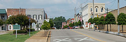
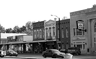
Glen is a town in Alcorn County, Mississippi. The population was 382 at the 2020 census, down from 412 at the 2010 census.

<span class="mw-page-title-main">Kossuth, Mississippi</span> Village in Mississippi, United States

Kossuth is a village in Alcorn County, Mississippi, United States. The population was 209 at the 2010 census.

<span class="mw-page-title-main">Clarksdale, Mississippi</span> City in Mississippi, United States

Clarksdale is a city in and the county seat of Coahoma County, Mississippi, United States. It is located along the Sunflower River. Clarksdale is named after John Clark, a settler who founded the city in the mid-19th century when he established a timber mill and business. Clarksdale is in the Mississippi Delta region and is an agricultural and trading center. Many African-American musicians developed the blues here, and took this original American music with them to Chicago and other northern cities during the Great Migration.

<span class="mw-page-title-main">Olive Branch, Mississippi</span> City in Mississippi, United States

Olive Branch is the 6th most populous city in Mississippi, US, located in DeSoto County. At the 2020 census the population was 39,711. Olive Branch is part of the Memphis Metropolitan Statistical Area, a region that consists of three counties in southwest Tennessee, five counties in northwest Mississippi, and two counties in eastern Arkansas. Olive Branch was the fastest-growing city in the United States, with a growth rate of 838% as of 2010 in a thirty year time frame. Along with other rapidly growing places in DeSoto County, Olive Branch attributes most of its growth and development to the exodus of large numbers of families from central Memphis.

<span class="mw-page-title-main">Holly Springs, Mississippi</span> City in Mississippi, United States

Holly Springs is a city in, and the county seat of, Marshall County, Mississippi, United States, near the border with Tennessee to the north. As of the 2020 census, the population was 6,968, down from 7,699 in 2010. Along with the Mississippi Delta, in the 19th century, the area was developed by European Americans for cotton plantations. After the Civil War, many freedmen continued to work in agriculture as sharecroppers and tenant farmers.

<span class="mw-page-title-main">Booneville, Mississippi</span> City in Mississippi, United States

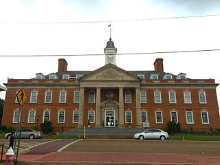
Booneville is a city in the U.S. state of Mississippi and is the county seat of Prentiss County. It is located in the hilly North Mississippi region, and ecologically is part of the Southeastern Plains region.

<span class="mw-page-title-main">Burnsville, Mississippi</span> Town in Mississippi, United States

Burnsville is a town in Tishomingo County in northeastern Mississippi, United States. The population was 936 at the 2010 census.

<span class="mw-page-title-main">Iuka, Mississippi</span> City in Mississippi, United States

Iuka is a city in and the county seat of Tishomingo County, Mississippi, United States. Its population was 3,028 at the 2010 census. Woodall Mountain, the highest point in Mississippi, is located just south of Iuka.

<span class="mw-page-title-main">Caruthersville, Missouri</span> City in Missouri, United States

Caruthersville is a city in and the county seat of Pemiscot County, Missouri, United States, located along the Mississippi River in the Bootheel region of the state's far southeast. The population was 5,562, according to the 2020 census.

<span class="mw-page-title-main">Southaven, Mississippi</span> City in Mississippi, United States

Southaven is a city in DeSoto County, Mississippi, United States. It is a principal city in Greater Memphis. The 2020 census reported a population of 54,648, making it the 3rd most populous city in Mississippi and the 2nd most populous suburb of Memphis. Southaven is traversed north to south by the I-55/I-69 freeway. The city's name derives from the fact that Southaven is located south of Whitehaven, a neighborhood in Memphis.

<span class="mw-page-title-main">Lawrenceburg, Tennessee</span> City in Tennessee, United States

The city of Lawrenceburg is the county seat of Lawrence County, Tennessee, United States, The largest city on the state's southern border between Chattanooga and Memphis, it lies on the banks of Shoal Creek. The population was 11,633 at the 2020 United States Census. The city is named after War of 1812 American Navy officer James Lawrence.

<span class="mw-page-title-main">Covington, Tennessee</span> City in Tennessee, United States

Covington is a city in central Tipton County, Tennessee, United States. Covington is the second largest city and county seat of Tipton County. The city is located in West Tennessee, 12 mi (19 km) east of the Mississippi River. The city's population was 9,038 at the time of the 2010 U.S. Census. Located 42 mi (68 km) northeast of Memphis, Covington is part of the Memphis, Tennessee Metropolitan Area.

<span class="mw-page-title-main">Angleton, Texas</span> City in Texas, United States

Angleton is a city in and the county seat of Brazoria County, Texas, United States, within the Houston–The Woodlands–Sugar Land metropolitan area. Angleton lies at the intersection of State Highway 288, State Highway 35, and the Union Pacific Railroad. The population was 19,429 at the 2020 census. Angleton is in the 14th congressional district, and is represented by Republican Congressman Randy Weber.

References

External image
Searchtool.svg Corinth, Miss. CollectionMississippi Department of Archives and History