
Union County is a county located in the U.S. state of Mississippi. It was formed in 1870 from Tippah and Pontotoc counties, and in 1874 a portion of Lee County was added. As of the 2020 census, the population was 27,777. Its county seat is New Albany. According to most sources, the county received its name by being a union of pieces of several large counties, like other Union counties in other states. However, other sources say that the name was meant to mark the re-union of Mississippi and the other Confederate states after the Civil War.
Tate County is a county located in the northwestern portion of the U.S. state of Mississippi. As of the 2020 census, the population was 28,064. Its county seat is Senatobia. Organized in 1873 during the Reconstruction era, from portions of DeSoto, Marshall, and Tunica counties, the county is named for Thomas Simpson Tate, one of the first prominent American settlers of the area.

Stone County is a county located in the U.S. state of Mississippi. As of the 2020 census, the population was 18,333. Its county seat is Wiggins. Stone County was formed from the northern portion of Harrison County on June 5, 1916. The county was named for John M. Stone, who served as Governor of Mississippi from 1876 to 1882 and again from 1890 to 1896.

Smith County is a county located in the U.S. state of Mississippi. As of the 2020 census, the population was 14,209. Its county seat is Raleigh.

Rankin County is a county located in the U.S. state of Mississippi. The western border of the county is formed by the Pearl River. As of the 2020 census, the population was 157,031, making it the fourth-most populous county in Mississippi. The county seat is Brandon. The county is named in honor of Christopher Rankin, a Mississippi Congressman who served from 1819 to 1826.
Pontotoc County is a county located in the U.S. state of Mississippi. As of the 2020 census, the population was 31,184. Its county seat is Pontotoc. It was created on February 9, 1836, from lands ceded to the United States under the Chickasaw Cession. Pontotoc is a Chickasaw word meaning "land of hanging grapes". The original Natchez Trace and the current-day Natchez Trace Parkway both pass through the southeast corner of Pontotoc County.

Newton County is a county located in the U.S. state of Mississippi. As of the 2020 census, the population was 21,291. Its county seat is Decatur.

Marion County is a county located in the U.S. state of Mississippi. As of the 2020 census, the population was 24,441. Its county seat is Columbia. Marion County is named for American Revolutionary War guerrilla leader Francis Marion also known as The Swamp Fox.
Madison County is a county located in the U.S. state of Mississippi. As of the 2020 census, the population was 109,145. The county seat is Canton. The county is named for Founding Father and U.S. President James Madison.

Leake County is a county in the center of the U.S. state of Mississippi. As of the 2020 census, the population was 21,275. Its county seat is Carthage. The county is named for Walter Leake, the Governor of Mississippi from 1822 to 1825.

Lamar County is a county located in the U.S. state of Mississippi. As of the 2020 census, the population was 64,222. Its county seat is Purvis. Named for Confederate Lucius Quintus Cincinnatus Lamar, the county was carved out of Marion County to the west in 1904.

Lafayette County is a county in the U.S. state of Mississippi. At the 2020 census, the population was 55,813. Its county seat is Oxford. The local pronunciation of the name is "la-FAY-et." The county's name honors Marquis de Lafayette, a French military hero and American general who fought during the American Revolutionary War.

Jefferson Davis County is a county located in the U.S. state of Mississippi. As of the 2020 census, the population was 11,321. Its county seat is Prentiss. The county is named after Mississippi Senator and Confederate President Jefferson Davis. The county was carved out of Covington and Lawrence counties in March 1906. Governor James K. Vardaman signed the bill creating the county on May 9, 1906.
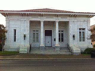
Jasper County is located in the U.S. state of Mississippi. At the 2020 census, the population was 16,367. In 1906, the state legislature established two county courts, one at the first county seat of Paulding in the eastern part of the county and also one at Bay Springs in the west, where the railroad had been constructed. Jasper County is part of the Laurel, MS Micropolitan Statistical Area.

Itawamba County is a county located in the U.S. state of Mississippi. As of the 2020 United States Census, the population was 23,863. Its county seat is Fulton. The county is part of the Tupelo, MS Micropolitan Statistical Area.
Harrison County is a county located in the U.S. state of Mississippi. As of the 2020 census, the population was 208,621, making it the second-most populous county in Mississippi. Its county seats are Biloxi and Gulfport. The county is named after U.S. President William Henry Harrison.

Hancock County is the southernmost county of the U.S. state of Mississippi and is named for Founding Father John Hancock. As of the 2020 census, the population was 46,053. Its county seat is Bay St. Louis.

Grenada County is a county located in the U.S. state of Mississippi. As of the 2020 Census, the population was 21,629. Its county seat is Grenada. The county was named for the province of Granada in southern Spain but spelled inaccurately. Its western half is part of the Mississippi Delta. Cotton cultivation was important to its economy well into the 20th century.
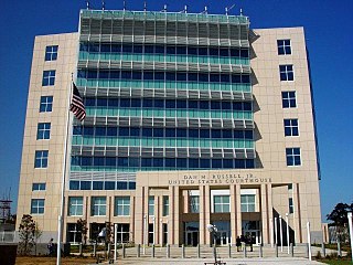
Forrest County is located in the U.S. state of Mississippi. As of the 2020 census, the population was 78,158. Its county seat and largest city is Hattiesburg. The county was created from Perry County in 1908 and named in honor of Nathan Bedford Forrest, a Confederate general in the American Civil War and the first Grand Wizard of the Ku Klux Klan. Forrest County is part of the Hattiesburg, MS Metropolitan Statistical Area.

Calhoun County is a county located in the U.S. state of Mississippi. As of the 2020 census, the population was 13,266. Its county seat is Pittsboro. The county is named after John C. Calhoun, the U.S. Vice President and U.S. Senator from South Carolina.


