The A82 is a major road in Scotland that runs from Glasgow to Inverness via Fort William. It is one of the principal north-south routes in Scotland and is mostly a trunk road managed by Transport Scotland, who view it as an important link from the Central Belt to the Scottish Highlands and beyond. The road passes close to numerous landmarks, including; Loch Lomond, Rannoch Moor, Glen Coe, the Ballachulish Bridge, Ben Nevis, the Commando Memorial, Loch Ness, and Urquhart Castle.
Loch Linnhe is a sea loch on the west coast of Scotland. The part upstream of Corran is known in Gaelic as An Linne Dhubh, and downstream as An Linne Sheileach. The name Linnhe is derived from the Gaelic word linne, meaning 'pool'.

Loch Garry is a freshwater Loch 25 km north of Fort William, Lochaber, Scotland. Loch Garry is 11 km long and 50 m deep. It is fed by waters from Loch Quoich 10 km upstream on the River Garry, and drains into Loch Oich in the Great Glen just 5 km downstream. Loch Garry is much photographed from the A87 for its romantic setting and also because a quirk of perspective makes it appear like a map of Scotland.
Glenelg (Scottish Gaelic: Glinn Eilg, also Gleann Eilg is a scattered community area and civil parish in the Lochalsh area of Highland in western Scotland. Despite the local government reorganisation the area is considered by many still to be in Inverness-shire, the boundary with Ross-shire being at the top of Mam Ratagan the single track road entry into Glenelg.
Loch Ericht is a freshwater loch on the border between Perth and Kinross and the Highlands Council areas of Scotland. It has a north-east to south-west orientation. The village of Dalwhinnie lies at the north east end of the loch. Loch Ericht is the tenth largest freshwater lake in Scotland and has a good reputation for its trout fishing and Ferox trout.
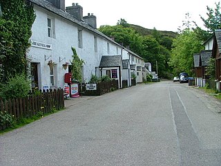
Tomdoun is a settlement on the north side of the River Garry, near the western end of Loch Garry, in Glen Garry in the Highlands of Scotland. The name comes from the Gaelic for "the brown hillock".

Clachaig; is a small settlement, on the Cowal peninsula in Argyll and Bute, Scotland. It is located on the B836 road between the Holy Loch and Loch Striven, the hamlet is just over a mile long. Clachaig is a Gaelic word meaning 'stone place'.
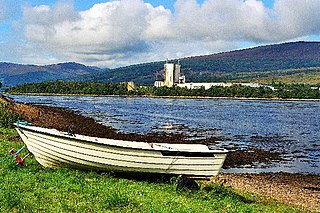
Achaphubuil is a small settlement to the north of Ardgour in Lochaber, in the Highlands of Scotland. Achaphubuil lies to the south of The Narrows, which link Loch Linnhe to Loch Eil. The village of Corpach is on the opposite shore, with Fort William across Loch Linnhe to the north-east.

Kintail is an area of mountains in the Northwest Highlands of Scotland, located in the Highland Council area. It consists of the mountains to the north of Glen Shiel and the A87 road between the heads of Loch Duich and Loch Cluanie; its boundaries, other than Glen Shiel, are generally taken to be the valleys of Strath Croe and Gleann Gaorsaic to the north and An Caorann Mòr to the east. Although close to the west coast the mountains lie on the main east–west watershed of Scotland, as the northern side of Kintail drains via Glen Affric to the east coast.

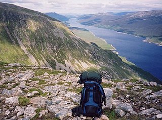
Loch Hourn is a sea loch which separates the peninsulas of Glenelg to the north and Knoydart to the south, on the west coast of Scotland.

Arnisdale is a hamlet in the historic county of Inverness-shire in the local authority area of Highlands of Scotland. It lies on the north shore of Loch Hourn, around 10 miles down a single-track road from Glenelg. It has a permanent population of around 30 and several holiday cottages. At the end of the village is a large white-painted hunting lodge called Arnisdale House, built by architects Robert John Macbeth & Alexander Ross in 1898-1916. The house was built for Valentine Fleming of the banking family, who was killed in action in World War I, a year after the house was completed.

Beinn Sgritheall is the highest mountain in the Glenelg area of the Highlands of Scotland. The main approach is via Arnisdale on the shores of Loch Hourn or via Gleann Beag to the north, with its well-known brochs. The view from the summit was described by Sir Hugh Munro, a founder member of the Scottish Mountaineering Club, as "perhaps the most beautiful I have seen in Scotland".

Garbh Uisge is a river of approximately 7 km in the Trossachs of Scotland just north-west Callander. It is the outflow of Loch Lubnaig and joins with Eas Gobhain west of Callander to form the River Teith. The name of the river, Garbh Uisge, is Gaelic for "Rough Water", reflecting the nature of the river. The river is often informally called the River Leny due to the Falls of Leny, where the river crosses the Highland Boundary Fault, and because it flows through the Pass of Leny.

Loch Alsh is a sea inlet between the isle of Skye in the Inner Hebrides and the Northwest Highlands of Scotland. The name is also used to describe the surrounding country and the feudal holdings around the loch. The area is rich in history, and is increasingly popular with tourists.

Beinn Chorranach is one of the Arrochar Alps, a mountain range that marks the start of the Argyll Highlands and provides a wilderness of long coastlines and high mountains with forested hill sides. Beinn Chorranach's parent peak is Beinn Ime, the biggest mountain in the range. Beinn Chorranach lies at the head of lower Glen Kinglas and is located between Loch Fyne and Loch Lomond. East of Beinn Chorranach is Loch Lomond as the mountain can be seen from Inversnaid and further east to The Trossachs wilderness. Further west is the rest of the wild Argyll scenery and marks the first real sense of isolation and wilderness after arriving in the Highlands at Loch Lomond.
Professor Peter English was a scientist, shinty player and social historian from Lochletter, Glen Urquhart, by the shores of Loch Ness, Highland, Scotland.
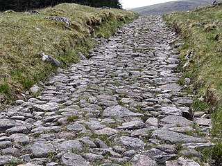
A network of military roads, sometimes called General Wade's Military Roads, was constructed in the Scottish Highlands during the middle part of the 18th century as part of an attempt by the British Government to bring order to a part of the country which had risen up in the Jacobite rebellion of 1715.

Loch Mullardoch is a major reservoir in Glen Cannich in the Northwest Highlands of Scotland. It was created by the damming in 1951 of the River Cannich just upstream of Mullardoch House, as part of the Affric-Beauly hydro-electric power scheme. A car park at the southern end of the dam is the terminus of the public road up Glen Cannich. The reservoir extends for about 14 km westwards up the glen to the point where the Abhainn a Choilich and Abhainn Sithidh burns drop down from the West Benula deer forest.
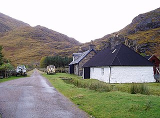
Kinloch Hourn is a small settlement at the end of Loch Hourn, in the West Highlands of Scotland. The name comes from the Gaelic, Ceann Loch Shubhairne, for "the head of Loch Hourn". Kinloch Hourn is at the end of 35 km of single-track road, which runs west from a junction with the A87 beside Loch Garry.

Druim Fada is a mountain in the Northwest Highlands of Scotland. Located on the northern shore of Loch Hourn in Ross and Cromarty.

