Country Club Park, Los Angeles

Last updated

Country Club Park
Country Club Park Signage.jpg
Country Club Park neighborhood sign located at Crenshaw Boulevard immediately north of Pico Boulevard
Location map Los Angeles.png
Red pog.svg
Country Club Park
Location within Central Los Angeles
Coordinates: 34°03′04″N118°19′19″W / 34.0511512°N 118.3218523°W / 34.0511512; -118.3218523
Country Flag of the United States.svg United States
State Flag of California.svg  California
County Flag of Los Angeles County, California.svg Los Angeles
Time zone Pacific
Zip Code
90019
Area code 323

Country Club Park is a neighborhood in Los Angeles, California.

Contents

History

The name Country Club Park refers to the area's previous use. In 1897, The Los Angeles Golf Club established a 9-hole course called the Windmill Links at Pico and Alvarado Street. Overcrowding inspired the organizers to move west and in 1899, the club moved to the corner of Pico and Western (the area that is now Country Club Park). The course remained there until 1910, at which time it moved to Holmby Hills. [1]

After The Los Angeles Golf Club moved west, Isaac Milbank, with partner George Chase, subdivided the property for mostly large homes and mansions. Country Club Park matured in the 1920s and homes were constructed in the latest architectural styles: Craftsman, Tudor Revival, Spanish Colonial Revival, Colonial Revival and Mediterranean Revival.

In the wake of the U.S. Supreme Court ruling in Shelley v. Kraemer (1948) which struck down racial exclusionary covenants, Country Club Park was one of the first affluent neighborhoods in Los Angeles to allow blacks to purchase homes. [2]

In 2010, the neighborhood was designated a Los Angeles Historic Preservation Overlay Zone because of the large number of intact buildings dating back to the earliest phases of Los Angeles’ development. [3]

Geography

Country Club Park is bounded by Olympic Boulevard on the north, Crenshaw Boulevard on the west, Pico Boulevard on the south, and Western Avenue on the east. [1] [4] The neighborhood of Arlington Heights is directly south. Wilshire Park is north. Oxford Square is west.

Country Club Park is partially gated; three streets that intersect Pico Boulevard are closed to through-traffic and pedestrians. [5]

The closed streets at Pico Boulevard, 2017
CCP Gate at Wilton.jpg
Wilton Place
CCPGateatGramercy.jpg
Gramercy Place
CCPGateatSt.Andrews.jpg
St. Andrews Place

Parks and recreation

In Media

1120 Westchester Place in
Country Club Park 1120 Winchester Place Los Angeles CA.jpg
1120 Westchester Place in
Country Club Park

Designed and built in 1902 by Alfred Rosenheim, the president of the American Institute of Architects' Los Angeles chapter, the Collegiate Gothic-style single family home is located at 1120 Westchester Place. The home was previously used as a convent. [7] An adjoining chapel was removed from exterior shots using CGI. [9]

After the pilot episode, filming continued on sets constructed to be an exact replica of the house. [10] Details such as Lewis Comfort Tiffany stained glass windows, and hammered bronze light fixtures, were re-created to preserve the look of the house. [7]

Notable residents

Related Research Articles

<span class="mw-page-title-main">Fairfax Avenue</span> Street in the city of Los Angeles, California

Fairfax Avenue is a street in the north central area of the city of Los Angeles, California, United States. It runs from La Cienega Boulevard in Culver City at its southern end to Hollywood Boulevard in Hollywood on its northern end. From La Cienega Boulevard to Sunset Boulevard, it separates the Westside from the central part of the city along with Venice Boulevard, La Cienega Boulevard, Hauser Boulevard, San Vicente Boulevard, South Cochran Avenue, Wilshire Boulevard, 6th Street, Cochran Avenue, 4th Street, La Brea Avenue, Fountain Avenue and Sunset Boulevard.

<span class="mw-page-title-main">Hancock Park, Los Angeles</span> Neighborhood of Los Angeles in California, United States

Hancock Park is a neighborhood in the Wilshire area of Los Angeles, California. Developed in the 1920s, the neighborhood features architecturally distinctive residences, many of which were constructed in the early 20th century. Hancock Park is covered by a Historic Preservation Overlay Zone (HPOZ).

<span class="mw-page-title-main">West Hills, Los Angeles</span> Neighborhood in Los Angeles, California, United States

West Hills is a suburban/residential community in the western San Fernando Valley region of the City of Los Angeles, California. The percentage of residents aged 35 and older is among the highest in Los Angeles County.

<span class="mw-page-title-main">Pico-Union, Los Angeles</span> Neighborhood of Los Angeles in California, United States of America

Pico-Union is a neighborhood in Central Los Angeles, California. The name "Pico-Union" refers to the neighborhood that surrounds the intersection of Pico Boulevard and Union Avenue. Located immediately west of Downtown Los Angeles, it is home to over 40,000 residents.

<span class="mw-page-title-main">Leimert Park, Los Angeles</span> Neighborhood of Los Angeles in California, United States

Leimert Park is a neighborhood in the South Los Angeles region of Los Angeles, California.

<span class="mw-page-title-main">West Adams, Los Angeles</span> Neighborhood of Los Angeles in California, United States

West Adams is a historic neighborhood in the South Los Angeles region of Los Angeles, California. The area is known for its large number of historic buildings, structures and notable houses and mansions. It contains several Historic Preservation Overlay Zones as well as designated historic districts.

<span class="mw-page-title-main">Rancho Park, Los Angeles</span> Neighborhood of Los Angeles in California, United States

Rancho Park is a residential neighborhood in the Westside of the city of Los Angeles, California with mostly single family homes and tree lined streets. The community is nestled between West Los Angeles and Cheviot Hills. This enclave draws young professionals and families and is home to residents working in a variety of professional occupations. History proves the neighborhood was once a part of Westwood until Olympic Blvd. was placed dividing the area North and South. The Southern section, now known as Rancho Park, felt cut off from its North side lobbying for its own identity in the 1930s.

<span class="mw-page-title-main">Baldwin Hills, Los Angeles</span> Neighborhood of Los Angeles in California, United States

Baldwin Hills is a neighborhood within the South Los Angeles region of Los Angeles, California. It is often referred to as the Black Beverly Hills.

Mid-Wilshire is a neighborhood in the central region of Los Angeles, California. It is known for the Los Angeles County Museum of Art, the Petersen Automotive Museum, and the Miracle Mile shopping district.

<span class="mw-page-title-main">El Sereno, Los Angeles</span> Neighborhood of Los Angeles in California, United States

El Sereno is a Los Angeles neighborhood in the Eastside Los Angeles region of Los Angeles County, California.

<span class="mw-page-title-main">Arlington Heights, Los Angeles</span> Neighborhood of Los Angeles in California, United States

Arlington Heights is a neighborhood in Central Los Angeles, California.

<span class="mw-page-title-main">South Robertson, Los Angeles</span> Neighborhood of Los Angeles in California, United States

South Robertson is an area on the Westside of Los Angeles that is served by the South Robertson neighborhood council. It contains the following city neighborhoods: Beverlywood, Castle Heights, Cheviot Hills, Crestview, La Cienega Heights and Reynier Village. The area is notable as a center for the Jewish community.

Pico Boulevard is a major Los Angeles street that runs from the Pacific Ocean at Appian Way in Santa Monica to Central Avenue in Downtown Los Angeles, California, United States. It is named after Pío Pico, the last Mexican governor of Alta California.

The western border of Santa Monica, California, is the 3-mile (4.8 km) stretch of Santa Monica Bay. On its other sides, the city is bordered by various districts of Los Angeles: the northwestern border is Pacific Palisades, the eastern border is Brentwood north of Wilshire Boulevard and West Los Angeles south of Wilshire, the northeastern border is generally San Vicente Boulevard up to the Riviera Country Club, the southwestern border is Venice Beach and the southern border is with West Los Angeles and Mar Vista.

<span class="mw-page-title-main">Wilshire Center, Los Angeles</span> Neighborhood of Los Angeles in California, United States of America

Wilshire Center is a neighborhood in the Wilshire region of Los Angeles, California.

<span class="mw-page-title-main">Victoria Park, Los Angeles</span> Neighborhood of Los Angeles in California, United States of America

Victoria Park is a neighborhood in the central region of Los Angeles, California. There are three Los Angeles Historic-Cultural Monuments located in Victoria Park.

<span class="mw-page-title-main">Los Angeles's 3rd City Council district</span> American legislative district

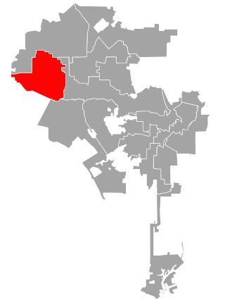
Los Angeles's 3rd City Council district is one of the fifteen districts in the Los Angeles City Council. It is currently represented by Democrat Bob Blumenfield since 2013 after winning an election to succeed Dennis Zine, who termed out and ran for City Controller that year.

<span class="mw-page-title-main">Wilshire Vista, Los Angeles</span> Neighborhood of Los Angeles in California, United States of America

Wilshire Vista is a neighborhood in the central region of Los Angeles.

Historic West Adams is a residential and commercial region along the route of the Rosa Parks Freeway, paralleling the east-west Adams Boulevard in Los Angeles, California. With variously described boundaries, the area was an exclusive residential district In the late 19th and early 20th centuries for many wealthy and influential people. It underwent a period of deterioration, but many of its stately old buildings have been and are being rehabilitated and preserved.

<span class="mw-page-title-main">Angelus Vista, Los Angeles</span> Neighborhood of Los Angeles in California, United States

Angelus Vista is a neighborhood in Los Angeles, California. There is one Los Angeles Historic-Cultural Monument in neighborhood.

References

  1. 1 2 Romero, Dennis (June 17, 2017). "L.A.'s Country Club Park Has Stately Homes and Deep History".
  2. 1 2 3 4 Powers, Kemp (January 24, 2008). "Neighborhood Project: Country Club Park". LAist. Archived from the original on November 5, 2017. Retrieved August 15, 2020. Most of Country Club Park was developed between 1910 and 1930. Originally segregated, it was one of the first affluent communities to allow African American residents, making it an early destination for upwardly-mobile blacks. Notable residents of the neighborhood have included Mahalia Jackson, Lou Rawls, Lena Horne, Hattie McDaniel, Tuskeegee Airman Celes King and many others.
  3. Preservation.lacity.org: Country Club Park HPOZ; with Survey Map, Adopting Ordinance, and Preservation Plan links.
  4. The Thomas Guide, 2006, page 633
  5. Smith, Dakota; Petrow-Cohen, Caroline (February 9, 2024). "Locked gates in historic L.A. neighborhood spark debate in City Council election". Los Angeles Times. Retrieved February 9, 2024.
  6. "Country Club Park Heritage Plaza". L.A. Department of Parks & Recreation. Los Angeles.
  7. 1 2 3 Keeps, David A. (October 31, 2011). "Set Pieces: The haunted house of 'American Horror Story'". Los Angeles Times . Retrieved November 5, 2011.
  8. Kudler, Adrian Glick (October 4, 2011). "American Horror Story Gave Alfred Rosenheim House in Country Club Park an Early Halloween Costume". Curbed.com. Retrieved October 13, 2011.
  9. Dos Santos, Kristin (January 27, 2012). "The American Horror Story House Is on the Market for How Much? Come Take a Tour Inside!". E! Online. Retrieved February 8, 2014.
  10. Chaney, Jen (October 5, 2011). "Connie Britton on 'American Horror Story,' 'Friday Night Lights' and what she learned from Rob Zombie". The Washington Post. Retrieved October 13, 2011.
  11. 1 2 3 Powers, Kemp (January 24, 2008). "Neighborhood Project: Country Club Park". LAist. Archived from the original on November 5, 2017. Retrieved August 15, 2020. According to a 2006 real estate feature in the Los Angeles Times, major films with segments shot in the neighborhood have included Daddy Day Care, Ali, Running With Scissors and many others.
  12. Los Angeles Street Address Telephone Directory. Los Angeles: Pacific Bell. January 1969. p. 210.
  13. Los Angeles Street Address Telephone Directory. Los Angeles: Pacific Bell. July 1973. p. 367.
  14. Powers, Kemp (January 24, 2008). "Neighborhood Project: Country Club Park". LAist. Archived from the original on November 5, 2017. Retrieved August 15, 2020. Most of Country Club Park was developed between 1910 and 1930. Originally segregated, it was one of the first affluent communities to allow African American residents, making it an early destination for upwardly-mobile blacks. Notable residents of the neighborhood have included Mahalia Jackson, Lou Rawls, Lena Horne, Hattie McDaniel, Tuskeegee Airman Celes King and many others.
  15. Los Angeles Street Address Telephone Directory. Los Angeles: Pacific Bell. July 1973. p. 83.