Fairfax Avenue is a street in the north central area of the city of Los Angeles, California. It runs from La Cienega Boulevard in Culver City at its southern end to Hollywood Boulevard in Hollywood on its northern end. From La Cienega Boulevard to Sunset Boulevard, it separates the Westside from the central part of the city along with Venice Boulevard, La Cienega Boulevard, Hauser Boulevard, San Vicente Boulevard, South Cochran Avenue, Wilshire Boulevard, 6th Street, Cochran Avenue, 4th Street, La Brea Avenue, Fountain Avenue and Sunset Boulevard.

Los Feliz is a hillside neighborhood in the greater Hollywood area of Los Angeles, California, abutting Hollywood and encompassing part of the Santa Monica Mountains. The neighborhood is named after the Feliz family of Californios who had owned the area since 1795, when José Vicente Feliz was granted Rancho Los Feliz.

Koreatown is a neighborhood in central Los Angeles, California, centered near Eighth Street and Irolo Street.

Pico-Union is a neighborhood in Central Los Angeles, California. The name "Pico-Union" refers to the neighborhood that surrounds the intersection of Pico Boulevard and Union Avenue. Located immediately west of Downtown Los Angeles, it is home to over 40,000 residents.
Little Ethiopia is located along South Fairfax Avenue, bordering the Mid-Wilshire and Pico-Robertson neighborhoods of central Los Angeles. It is known for its collection of Ethiopian and Eritrean restaurants, coffee shops, boutiques and thrift stores.
Picfair Village is a neighborhood in the Central area of the city of Los Angeles, California.
Carthay Circle is a neighborhood in the Mid-City West region of Central Los Angeles, California. Originally named Carthay Center, the neighborhood was later re-named after the famed Carthay Circle Theatre.

Wilshire Boulevard is a prominent 15.83 mi (25.48 km) boulevard in the Los Angeles area of Southern California, extending from Ocean Avenue in the city of Santa Monica east to Grand Avenue in the Financial District of downtown Los Angeles. One of the principal east-west arterial roads of Los Angeles, it is also one of the major city streets through the city of Beverly Hills. Wilshire Boulevard runs roughly parallel with Santa Monica Boulevard from Santa Monica to the west boundary of Beverly Hills. From the east boundary it runs a block south of Sixth Street to its terminus.
Mid-Wilshire is a neighborhood in the central region of Los Angeles, California. It is known for the Los Angeles County Museum of Art, the Petersen Automotive Museum, and the Miracle Mile shopping district.
Mid City is a neighborhood in Central Los Angeles, California.

San Vicente Boulevard is a major northwest-southeast thoroughfare located in the western portion of the metropolitan area of Los Angeles, CA.
Pico Boulevard is a major Los Angeles street that runs from the Pacific Ocean at Appian Way in Santa Monica to Central Avenue in Downtown Los Angeles, California, USA. It is named after Pío Pico, the last Mexican governor of Alta California.
The western border of Santa Monica, California, is the 3-mile (4.8 km) stretch of Santa Monica Bay. On its other sides, the city is bordered by various districts of Los Angeles: the northwestern border is Pacific Palisades, the eastern border is Brentwood north of Wilshire Boulevard and West Los Angeles south of Wilshire, the northeastern border is generally San Vicente Boulevard up to the Riviera Country Club, the southwestern border is Venice Beach and the southern border is with West Los Angeles and Mar Vista.
Mid-City West is a subregion in the western part of the Central Los Angeles region, served by the Mid City West Neighborhood Council.

Victoria Park is a small neighborhood in the central region of Los Angeles, California. There are three Los Angeles Historic-Cultural Monuments located in Victoria Park.
Los Angeles City Council District 10 is one of the 15 districts of the Los Angeles City Council.
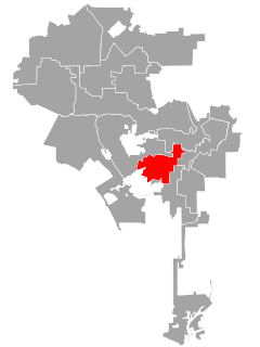
Brookside is a neighborhood in Los Angeles, California. It is an enclave of eight tree-lined streets and 400 homes. The neighborhood consists primarily of one-story and two-story, predominantly single-family residences in various Period Revival styles including Spanish Colonial Revival, Tudor Revival, Mediterranean Revival, and French Revival; later buildings were constructed in the Minimal Traditional and Ranch styles.

Beverly Grove is a neighborhood adjacent to Beverly Hills, California, within the Beverly–Fairfax neighborhood in the Mid-City West area of Los Angeles.
Liberty Park is a private park in Los Angeles, CA. It is located on Wilshire Boulevard in the Koreatown Neighborhood. It is now considered a L.A. City Cultural Monument.

Angelus Vista is a neighborhood in Los Angeles, California.