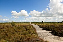
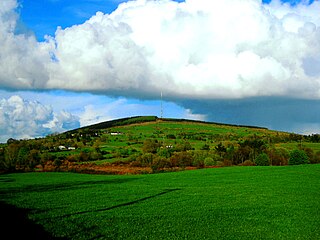
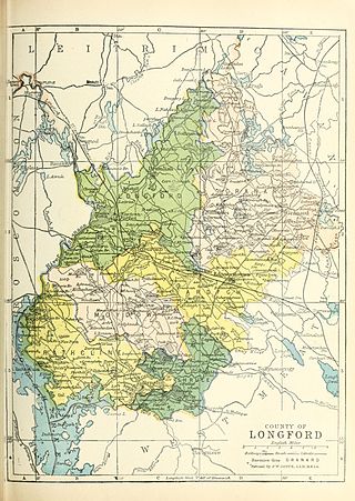
Most of Longford lies in the basin of the River Shannon with Lough Ree forming much of the county's western boundary. The north-eastern part of the county, however, drains towards the River Erne and Lough Gowna. Lakeland, bogland, pasture-land and wetland typify Longford's generally low-lying landscapes: the highest point of the county is in the north-west – Carn Clonhugh (also known as Cairn Hill or Corn Hill) between Drumlish and Ballinalee in the parish of Killoe, at 278 metres (912ft). Cairn Hill is the site of a television transmitter broadcasting to much of the Irish midlands.
In the list of Irish counties by highest point, Longford ranks third lowest – only Meath and Westmeath have lower maxima. In general, the northern third of the county is hilly, forming part of the drumlin belt and Esker Riada stretching across the northern midlands of Ireland. The southern parts of the county are low-lying, with extensive areas of raised bogland and the land being of better quality for grazing and tillage. The River Shannon marks the county's border with Roscommon while the Rivers Inny and Tang form much of the boundary with Westmeath.
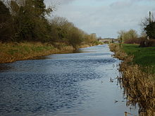
The Royal Canal flows through the south of the county terminating at Cloondara at the Shannon. The canal was refurbished and reopened in 2010. Notable lakes include Lough Kinale and Lough Gowna on the County Cavan border, Lough Forbes on the County Roscommon border and Lough Ree in the south where counties Longford, Westmeath and Roscommon meet.
The territory corresponding to County Longford was presumably a frontier colony of the Kingdom of Meath in the first millennium. Between the fifth and twelfth centuries, the territory was called the kingdom of Tethbae ruled by various tuath such as the Cairpre Gabra in the north. Tethbae (Latin: Teffia) originally referred to an area north of the River Inny approximating to present-day County Longford.[4]
In the year AD 1070, Tethbae was conquered by the Ó Cuinns, Ó Fearghails and other Conmhaícne tribes, henceforth being known as "Muintir Annaly", so named after "Anghaile" the great-grandfather of Fearghail O'Farrell. Furthermore, County Longford was often called Upper Conmaicne, to distinguish it from south Leitrim, then called Lower Conmaicne, because both districts were ruled by the descendants of Conmac, son of Fergus and Queen Meadbh of Connacht.[5][6]
Following the Norman invasion of the 12th century, Annaly was granted to Hugh de Lacy as part of the Liberty of Meath. An English settlement was established at Granard, with Norman Cistercian monasteries being established at Abbeylara and Abbeyshrule and Augustinian monasteries at Abbeyderg and at Saints' Island on the shore of Lough Ree. Monastic remains at Ardagh, Abbeylara, Abbeyderg, Abbeyshrule, Inchcleraun Island in Lough Ree and Inchmore Island in Lough Gowna are reminders of the county's long Christian history. However, by the 14th century, English influence in Ireland was on the wane. The town of Granard was sacked by Edward Bruce's army in 1315, and the O'Farrells soon recovered complete control over the territory. Annaly later became Longphoirt, now Longford, after O'Farrell's fortress of this name.[7]
The county was officially shired in 1586 in the reign of Elizabeth I from the northern portion of Westmeath,[8] but English control was not fully established until the aftermath of the Nine Years' War. County Longford was added to Leinster by James I in 1608 (it had previously been considered part of Connacht), with the county being divided into six baronies and its boundaries being officially defined. The county was planted by English and Scottish landowners in 1620, with much of the O'Farrell lands being confiscated and granted to new owners. The change in control was completed during the Cromwellian plantations of the 1650s. On these lands in County Longford, are the historic ruins of the Coolamber Hall House, which was besieged by one of the Cromwells.
The county was a centre of the 1798 rebellion, when the French expeditionary force led by Humbert, which had landed at Killala, was defeated outside the village of Ballinamuck on 8 September by a British army led by Cornwallis. General Humbert had hoped to amalgamate his forces with other rebels located in Granard but Cornwallis aware of the danger had defeated these forces in the second battle of Granard prior to defeating General Humbert in Ballinamuck. Considerable reprisals were inflicted by the British on the civilian inhabitants of the county in the aftermath of the battle.
A revolutionary spirit was again woken in the county during the Irish War of Independence when the North Longford flying column, led by Seán Mac Eoin, became one of the most active units on the Irish side during that war.
Education
There are many national and secondary schools located in the county such as Moyne Community School, St. Mels and the Convent (Longford, Granard, Ballymahon, Lanesborough).
Demographics
This section needs to be updated. Please help update this article to reflect recent events or newly available information.(January 2019)
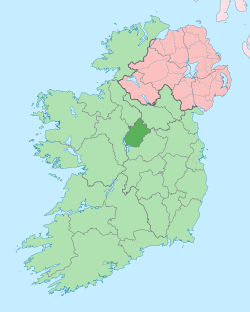
With an area of 1,091km2 (421sqmi) and a population of 46,634,[2] Longford is the fourth smallest of the 32 counties in area and second smallest in terms of population.[16] It is also the fourth smallest of Leinster's 12 counties by size and smallest by population. It borders counties Cavan to the northeast, Westmeath to the southeast, Roscommon to the southwest and Leitrim to the northwest.
Longford's population growth during the period 2002–2006 (10.6%) has been stronger than the National average (8.2%).[17]
Agriculture is an important facet in the way of life and for the economy in County Longford. There are 73,764 hectares of area (67.6% of the county's total area) farmed in the county. There are approximately 126,904 cattle in the county too.[18]
↑ Lee, JJ (1981). "On the accuracy of the Pre-famine Irish censuses". In Goldstrom, J. M.; Clarkson, L. A. (eds.). Irish Population, Economy, and Society: Essays in Honour of the Late K. H. Connell. Oxford, England: Clarendon Press.
↑ Corry, Eoghan (2005). The GAA Book of Lists. Hodder Headline Ireland. pp.186–191.
↑ "Demographic context"(PDF). Offaly County Council Development Plan 2009 – 2015. Archived from the original(PDF) on 30 October 2008. Retrieved 28 June 2008.
Ó Duígeannáin, Mícheál (1934). "Notes on the History of the Kingdom of Bréifne". The Journal of the Royal Society of Antiquaries of Ireland. The Journal of the Royal Society of Antiquaries of Ireland, Volumes 64–65 (1) (Digitized 2008 from original at the University of Californiaed.). Royal Society of Antiquaries of Ireland: 113–140. JSTOR25513764.
Dobbs, Margaret E. (1938). "The Territory and People of Tethba". The Journal of the Royal Society of Antiquaries of Ireland. Seventh Series, Vol. 8, No. 2 (2). Royal Society of Antiquaries of Ireland: 241–259. JSTOR25510138.
Ballymahon on the River Inny is a town in the southern part of County Longford, Ireland. It is located at the junction of the N55 National secondary road and the R392 regional road.
Longford is the county town of County Longford in Ireland. It had a population of 10,952 at the 2022 census. It is the biggest town in the county and about one third of the county's population lives there. Longford lies at the meeting of Ireland's N4 and N5 National Primary Route roads, which means that traffic travelling between Dublin and County Mayo, or north County Roscommon passes around the town. Longford railway station, on the Dublin-Sligo line, is used heavily by commuters.
The N55 road is a national secondary road in Ireland linking Athlone to Cavan town.
The Longford County Board of the Gaelic Athletic Association (GAA) or Longford GAA is one of the 32 county boards of the GAA in Ireland, and is responsible for Gaelic games in County Longford. The county board is also responsible for the Longford county teams.
Corn Hill, also called Cairn Hill or Carn Clonhugh, is a hill in County Longford, Republic of Ireland. It lies north of Longford, between Drumlish and Ballinalee, in the parish of Killoe. At 278 metres above sea level, it is the highest hill in the county and has a television mast on the top which rises 123 metres above the peak of the hill.
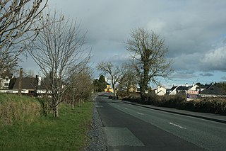
Ballinalee, sometimes known as Saint Johnstown, is a village in north County Longford, Ireland. It is situated on the River Camlin, and falls within the civil parish of Clonbroney. As of the 2016 census, the village had a population of 347 people.
Mullinalaghta, also officially referred to as Mullanalaghta, is a half-parish in the north-eastern part of County Longford, Ireland, located about eight kilometres north of Granard.
The Diocese of Ardagh and Clonmacnoise is a Latin Church diocese of the Catholic Church in Ireland.
Lanesborough–Ballyleague, more commonly known simply as Lanesborough, is a town in the midlands of Ireland. Lanesborough is on the County Longford (east) side and Ballyleague on the County Roscommon (west) side of the River Shannon, at the northern tip of Lough Ree.
The R392 road is a regional road in Ireland linking Lanesborough, County Longford on the N63 to Mullingar, County Westmeath.
The Clonfin Ambush was an ambush carried out by the Irish Republican Army (IRA) on 2 February 1921, during the Irish War of Independence. It took place in the townland of Clonfin between Ballinalee and Granard in County Longford. The IRA ambushed two lorries carrying members of the British Auxiliary Division, sparking a lengthy gun battle in which four Auxiliaries were killed and eight wounded. The Auxiliaries eventually surrendered and their weapons were seized. The IRA commander, Seán Mac Eoin, won some praise for helping the wounded Auxiliaries. Following the ambush, British forces burned a number of houses and farms in the area, and shot dead an elderly farmer.
The River Inny is a river within the Shannon River Basin in Ireland. It is 88.5 kilometres (55.0 mi) in length, and has a number of lakes along its course.
Tethbae was a confederation of túatha in central Ireland in the Middle Ages. It was divided into two distinct kingdoms, north Tethba, ruled by the Cenél Coirpri, and south Tethba, ruled by the Cenél Maini. It covered parts of County Westmeath and much of County Longford, counties which today are the far north-west part of the province of Leinster. In some cases, Tethbae may refer to South Tethbae only.
The High Sheriff of Longford was the British Crown's judicial representative in County Longford, Ireland from the 16th century until 1922, when the office was abolished in the new Free State and replaced by the office of Longford County Sheriff. The sheriff had judicial, electoral, ceremonial and administrative functions and executed High Court Writs. In 1908, an Order in Council made the Lord-Lieutenant the Sovereign's prime representative in a county and reduced the High Sheriff's precedence. However the sheriff retained his responsibilities for the preservation of law and order in the county. The usual procedure for appointing the sheriff from 1660 onwards was that three persons were nominated at the beginning of each year from the county and the Lord Lieutenant then appointed his choice as High Sheriff for the remainder of the year. Often the other nominees were appointed as under-sheriffs. Sometimes a sheriff did not fulfil his entire term through death or other event and another sheriff was then appointed for the remainder of the year. The dates given hereunder are the dates of appointment. All addresses are in County Longford unless stated otherwise.
The Shannon River Basin consists of the area containing Ireland's longest river, the River Shannon, and all of its tributaries and lakes. The official Ordnance Survey Ireland length of the Shannon from its Shannon Pot source is 224 miles (360 km) made up of 63.5 miles (102.2 km) tidal water flow and 160.5 miles (258.3 km) freshwater flow.
Granard is a barony in County Longford, Ireland.
Rathcline is a barony in County Longford, Ireland.
Between the 5th and 12th centuries, an Irish sept claiming descent from Coirpre mac Néill ruled a barony of north Tethbae, called Cairpre Gabra. Their territory corresponds to the barony of Granard in modern county Longford in Ireland.
An election to all 18 seats on Longford County Council was held on 24 May 2019 as part of the 2019 Irish local elections. County Longford was divided into 3 local electoral areas (LEAs) to elect councillors for a five-year term of office on the electoral system of proportional representation by means of the single transferable vote (PR-STV).
This page is based on this Wikipedia article Text is available under the CC BY-SA 4.0 license; additional terms may apply. Images, videos and audio are available under their respective licenses.