Lough Gowna

Last updated

Lough Gowna
Lough Gowna (230569952).jpg
Ireland relief location map.png
Red pog.svg
Lough Gowna
Location County Cavan and County Longford
Coordinates 53°51′N7°33′W / 53.850°N 7.550°W / 53.850; -7.550 Coordinates: 53°51′N7°33′W / 53.850°N 7.550°W / 53.850; -7.550
Type Moraine dammed lake
Native nameLoch Gamhna  (Irish)
Primary inflows River Erne
Primary outflows River Erne
Basin  countriesIreland
Islands Inchmore
SettlementsLoch Gowna, Colmcille, Mullinalaghta, Dromard, Mullahoran

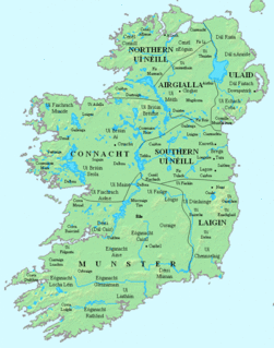
Lough Gowna (Irish : Loch Gamhna, meaning 'calf lake') [1] is a fresh water lake which is the uppermost lake on the River Erne. It is located on the border between County Longford and County Cavan, with the largest part of the lake being in County Longford.

Contents

Lough Gowna is a moraine-dammed lake formed at the end of the last glaciation, and owes its complex indented shape to the underlying drumlin landscape. This results in a large number of bays and inlets on the lake, often connected by narrow channels. The river Erne enters the system in a western direction into the easternmost part of the lake (locally known as Derries Lough) and exits northward through County Cavan. However, the damming caused by the moraines that gave rise to the lake result in large bodies of water to the north-west and south-west which form the bulk of the area of the lake. A number of other small rivers also flow into the lake. The county border runs through the north-western part of the lake, and then turns eastwards, with the western and southern parts of the lake being in Longford and the north-eastern parts being in Cavan.

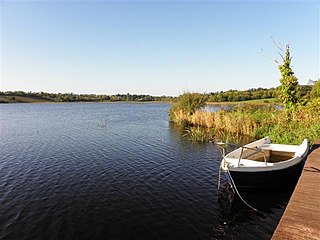
The north-western and south-western portions of the lake are connected by a narrow channel at Dernaferst (a townland on the western (Longford) shore of the lake, but which is in County Cavan). The northern and eastern shores of the lake are surrounded by peat bog, with areas of planted woodland along the southern shores of the lake in former demesnes in the townlands of Derrycassan and Culray. The lake is considered to be an important site for wintering wildfowl.

The lake contains one large island in the south-western part, Inchmore (Inis Mór in Irish, meaning "Big island"), which was the site of a monastery founded in the sixth century by Saint Colmcille. The monastery was raided by the Vikings in 804, being burned and looted. During the twelfth century, the abbey conformed to Augustinian rules and remained there until the dissolution of the monasteries by King Henry VIII in 1543. The site was still used as a graveyard by the local population until the early years of the twentieth century. The remains of the abbey are still to be seen on the island. A fifteenth-century tower bell, reputedly from the monastery, was recovered in the nineteenth century and now hangs in the Roman Catholic church in the nearby village of Aughnacliffe.

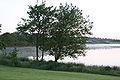
Lough Gowna is an important centre for coarse fishing and the shape of the lake, with wooded peninsulas interspersed with bays and inlets, make it attractive for tourism. There are picnic sites at Dernaferst and at Dring (at the southernmost point of the lake).

The name of the lake comes from a legend about a supernatural calf which escaped from a well in the townland of Rathcor (south of the lake) and raced northward with a stream of water from the well following it and flooding the area now making up the lake.

The lake gives its name to the village of Loch Gowna, which is near the north-eastern shore of the lake in County Cavan. The original name of the village was Scrabby (Screabach in Irish), and gave its name to the townland and parish in which it is located. However, in 1950, after a plebiscite of the villagers, the name was officially changed to Loch Gowna. [2] The village, which actually sits on the shores of Swan Lake, acts as a service centre for tourism, with hotel accommodation and sizeable numbers of holiday homes in the area.

Other parishes adjacent to the lake are Colmcille on the western and southern shores of the lake, Mullinalaghta on the eastern shore, and Dromard in the extreme north-west, all in County Longford; and Mullahoran in the extreme east where the Erne enters the lake, in County Cavan.

Dopping-Hempenstall

In the 19th c the Dopping-Hempenstall family had a large yacht on the lake for their private use. it was built in iron by Bewley and Webb in Dublin.

See also

Related Research Articles

<span class="mw-page-title-main">County Longford</span> County in Ireland

County Longford is a county in Ireland. It is in the province of Leinster. It is named after the town of Longford. Longford County Council is the local authority for the county. The population of the county was 46,634 at the 2022 census. The county is based on the historic Gaelic territory of Annaly (Anghaile), formerly known as Teffia (Teathbha).

<span class="mw-page-title-main">County Cavan</span> County in Ireland

County Cavan is a county in Ireland. It is in the province of Ulster and is part of the Border Region. It is named after the town of Cavan and is based on the historic Gaelic territory of East Breffny (Bréifne). Cavan County Council is the local authority for the county, which had a population of 76,176 at the 2016 census.

Lough Erne Body of water

Lough Erne is the name of two connected lakes in County Fermanagh, Northern Ireland. It is the second-biggest lake system in Northern Ireland and Ulster, and the fourth biggest in Ireland. The lakes are widened sections of the River Erne, which flows north and then curves west into the Atlantic. The smaller southern lake is called the Upper Lough as it is higher up the river. The bigger northern lake is called the Lower Lough or Broad Lough. The town of Enniskillen lies on the short stretch of river between the lakes. The lake has more than 150 islands, along with many coves and inlets. The River Erne is 80 miles (129 km) long and drains an area of about 1680 square miles (4,350 km2).

Lough Ree Lake in Ireland

Lough Ree is a lake in the midlands of Ireland, the second of the three major lakes on the River Shannon. Lough Ree is the second largest lake on the Shannon after Lough Derg. The other two major lakes are Lough Allen to the north, and Lough Derg to the south. There are also several minor lakes along the length of the river. The lake serves as a border between the counties of Longford and Westmeath on the eastern side and County Roscommon in the province of Connacht on the western side. The lake is popular for fishing and boating. The lake supports a small commercial eel fishery and is locally famous for its eels on wheels truck. The town of Athlone is situated at the southern end of the lake, and has a harbour for boats going out on the lake. The small town of Lanesboro is at the northern end of the lake.

River Erne River in northwestern Ireland

The River Erne in the northwest of the island of Ireland, is the second-longest river in Ulster, flowing through Northern Ireland and the Republic of Ireland, and forming part of their border.

Lough Ramor Body of water

Lough Ramor is a large natural lake of 741 hectares situated near Virginia, County Cavan. From early records Vita Tripartita identified as being in the territory of Cenal Muinreamhair. The literal meaning of the term Muinreamhair is 'fat-neck' and appears to be derived from a prehistoric or mythical ancestor warrior, connoting great strength. Loch Muinreamhair also appears in early manuscripts of the Four Masters.

Mullinalaghta, also officially referred to as Mullanalaghta, is a half-parish in the north-eastern part of County Longford, Ireland, located about eight kilometres north of Granard.

Ballycassidy Human settlement in Northern Ireland

Ballycassidy is a small village and townland in County Fermanagh, Northern Ireland, 6.5 km north of Enniskillen on the eastern shore of Lower Lough Erne. It is situated in the civil parish of Trory and the historic barony of Tirkennedy. In the 2001 Census it had a population of 315 people. It is situated within Fermanagh and Omagh district.

Lough MacNean Body of water

Lough MacNean is a large freshwater lake on the border between Northern Ireland and the Republic of Ireland.

Newtowncashel is a village located near Lough Ree in County Longford, Ireland. It is within the townland of Cornadowagh. Newtowncashel won the Irish Tidy Towns Competition in 1980.

Lough Oughter Body of water

Lough Oughter is a lake, or complex of lakes, in County Cavan covering more than 8,900 hectares. The complex of lakes lies on the River Erne, and forms the southern part of the Lough Erne complex. The lakes are bounded roughly by Belturbet in the north, Cavan town to the east, Crossdoney to the south and Killeshandra to the west.

River Inny (Leinster) Tributary of the Shannon in central Ireland

The River Inny is a river within the Shannon River Basin in Ireland. It is 88.5 kilometres (55.0 mi) in length, and has a number of lakes along its course.

Black Pigs Dyke Linear earthworks in Ireland

The Black Pig's Dyke or Worm's Ditch is a series of discontinuous linear earthworks in southwest Ulster and northeast Connacht, Ireland. Remnants can be found in north County Leitrim, north County Longford, County Cavan, County Monaghan and County Fermanagh. Sometimes, the Dorsey enclosure in County Armagh and the Dane's Cast in County Down are considered to be part of the dyke.

Moygoish Barony in Leinster, Ireland

Moygoish is a barony in north County Westmeath, in the Republic of Ireland, formed by 1672. It is bordered by County Longford to the west and four other Westmeath baronies: Corkaree, Fore, Moyashel and Magheradernon and Rathconrath to the south–west.

Lough Scur Lake in south County Leitrim, Ireland

Lough Scur is a freshwater lake in south County Leitrim, northwest Ireland. It is part of the Shannon–Erne Waterway. There have been Human settlements here since the New Stone Age. Modern features include quays and moorings. Protected features are Castle John, three Crannogs, and the causeway into Rusheen Island, though "Jail Island" is not protected. The ecology of Lough Scur, and indeed all county Leitrim lakes, is threatened by pollution and invasive species such as curly waterweed, zebra mussel, and freshwater clam.

Lough Conway is a very small freshwater lake in northwest Ireland.

<span class="mw-page-title-main">Cairpre Gabra</span> Irish barony (5th to 12th centuries)

Between the 5th and 12th centuries, an Irish sept claiming descent from Coirpre mac Néill ruled a barony of north Tethbae, called Cairpre Gabra. Their territory corresponds to the barony of Granard in modern county Longford in Ireland.

Aughnacliffe, officially Aghnacliff , is a village in County Longford, Ireland. It is located close to Lough Gowna and the border with County Cavan.

<span class="mw-page-title-main">Finn River (County Fermanagh and County Monaghan)</span> Small river in Ulster, Ireland

The Finn River, also known as the River Finn, is a small river that flows through parts of County Fermanagh and parts of County Monaghan in the south of Ulster, the northern province in Ireland. In certain places, the river forms part of the boundary between County Fermanagh, which is part of Northern Ireland, and County Monaghan, which is part of the Republic of Ireland. Two very short stretches of the river, just north of Redhills and at Castle Saunderson, near Belturbet, also form part of the boundary between County Fermanagh and County Cavan. This means that some stretches of the river form part of the border between Northern Ireland and the Republic of Ireland, these short stretches also forming part of the external border of the European Union.

Rockfield Lake, also known as Rockfield Lough, is a lake or lough situated between Carrigallen and Killeshandra, two small towns on the northern edge of the Midlands in Ireland. Part of the lake is in County Leitrim, which is part of the Province of Connacht, while most of the lake is in County Cavan, which is part of the Province of Ulster. This means that the provincial boundary between Connacht and Ulster runs through the lough. The Cullies River flows through Rockfield Lake, entering the lake at its southern end and flowing out of the lake at its north-western end. This small river flows from nearby Cullies Lake, and flows on, via Drumhart Lake, through Rockfield Lake to Glasshouse Lake.

References

  1. "Loch Gamhna/Lough Gowna". Placenames Database of Ireland (logainm.ie). Department of Culture, Heritage and the Gaeltacht and Dublin City University . Retrieved 14 March 2020.
  2. S.I. No. 170/1950 - Local Government (Change of Name of Townland) Order, 1950. https://www.irishstatutebook.ie/eli/1950/si/170/made/en/print