Crayford

Last updated

Crayford
River Cray at Crayford, Kent - geograph.org.uk - 137404.jpg
Greater London UK location map 2.svg
Red pog.svg
Crayford
Location within Greater London
Population11,226 (2011 Census. Ward) [1]
OS grid reference TQ515745
  Charing Cross 13.7 mi (22.0 km)  WNW
London borough
Ceremonial county Greater London
Region
Country England
Sovereign state United Kingdom
Post town DARTFORD
Postcode district DA1
Dialling code 01322
Police Metropolitan
Fire London
Ambulance London
UK Parliament
London Assembly
List of places
UK
England
London
51°26′57″N0°10′52″E / 51.4491°N 0.1812°E / 51.4491; 0.1812

Crayford is a town and electoral ward in South East London, England, within the London Borough of Bexley. It lies east of Bexleyheath and north west of Dartford. Crayford was in the historic county of Kent until 1965. The settlement developed by the river Cray, around a ford that is no longer used.

Contents

History

Lion remains from Crayford; dated to the Palaeolithic Lion Skull from Crayford in the Museum of London.jpg
Lion remains from Crayford; dated to the Palaeolithic

An Iron Age settlement existed in the vicinity of the present St Paulinus Church between the Julian and Claudian invasions of Britain, from roughly 30 BC to AD 40. Roman ruins have been discovered and Crayford is one of several places proposed as the site of Noviomagus Cantiacorum, a place mentioned in the Antonine Itinerary as being on the Roman equivalent of the later Watling Street. Crayford is also plausible as the site of the bloody battle of Crecganford ("Creeksford") in 457 in which Hengist defeated Vortimer to become the supreme sovereign of Kent. [2] [3] The Anglo-Saxon Chronicle written around 400 years later describes how Hengist and Æsc defeated the "Brettas" at that battle.

Crayford is mentioned in the Domesday Book, which was compiled just prior to 1086, as a settlement within the Hundred of Litlelee with a church, three mills, and a relatively large population of 27 regular householders (villeins) and two smallholders. Its overlord was not a private individual or the king but Christ Church, Canterbury. [4]

As a (civil/combined) parish (before 1920) it included the hamlets of Northend, Perry Street and Slade Green which lie to the north. In 1831, the population of the parish was 2022 people. [5] For centuries it was strongly associated with brick-making, the printing of silk scarves, ties and calico cloths, and for a short period carpet-making.

Crayford Manor House, reconstructed in 1816 Crayford, Manor House - geograph.org.uk - 173749.jpg
Crayford Manor House, reconstructed in 1816
1887 photograph of May Place May Place, Crayford.jpg
1887 photograph of May Place

There were two main Manor Houses in the area during the Middle Ages, Newbery Manor on the site of what is now Crayford Manor House, and Howbury Manor next to Slade Green. Roger Apylton had served Kings Henry V and Henry VI as auditor, and resided at Marshalls Court, Crayford. Late in the reign of Elizabeth I Henry Partich sold Newbery Manor to Henry Apylton of Marshalls Court, and Apylton built May Place close by. [6] Hall Place, which lies alongside the River Cray, was built for Lord Mayor of the City of London Sir John Champneis in around 1537. There was also an Iron Mill, which was later replaced by a saw mill (in 1765), which produced the timber for the floor of Buckingham Palace. [5] In 1551 Francis Goldsmith bought a 'Great tenement called The Place' next to the bridge in Crayford, and between 1556 and 1586 purchased substantial amounts of local farmland and the Old Bell Public House. [7]

In 1623 most of the parish of Crayford was purchased by Merchant Taylor Robert Draper [8] including Newbery Manor, Howbury Manor, Marshalls Court and May Place, where his family took up residence. Draper's wife Anne was the daughter of Thomas Harman who lived at Ellam House which subsequently passed to the Drapers. [9] The ownerships subsequently passed to Robert Draper's son William, who was selected to be the Sheriff of the County of Kent but died in 1650 before taking office, and then to Robert's grandson, parliamentarian Cresheld Draper. On the death of Cresheld Draper in 1694, his heirs sold all the properties to Sir Cloudesley Shovell'. [9]

Crayford Manor House was rebuilt in the eighteenth century, at the time essentially a farmhouse until it was remodelled in 1816 for the Rev. Thomas Barne. Historic England state it was built piecemeal over several periods, with a porch and Italianate features being added to the 1816 building. [10]

Other notable 19th-century local houses included Shenstone (built around 1828 and demolished 1974, the site is now Shenstone School, with Shenstone's former grounds now being Shenstone Park), [11] Stoneyhurst (which became Stoneyhurst Convent High School and is now the site of St Catherine's Roman Catholic School for Girls), [12] [13] Martens Grove and Oakwood - the latter two designed by architect John Shaw Jr. and built by George Locke of builders Locke & Nesham with each occupying one of the houses. [14]

Industrialisation

In 1819, the former saw mill site became a flour mill. Another major employer was the silk works set up by Augustus Applegath and later run by David Evans. The Maxim Nordenfeldt Gun and Ammunition Factory was also a major employer, until taken over by the Vickers Company in 1897. Vickers built military aeroplanes and armaments and became the dominant employer, building homes, a theatre and a canteen close to many workshops. The canteen (built during the First World War) was converted for use by the Crayford Urban District Council as Crayford Town Hall and is a locally listed building. [15]

Another former major employer in Crayford was Dussek Brothers (part of Burmah-Castrol since the 1960s) who operated their oils and waxes blending business on Thames Road from around 1928 until the site was bought by BP and subsequently closed down in 2001. The entire site was demolished in early 2010. The David Evans silk works is another recent closure, in 2002.

In 1982 a housing cooperative was built at Craymill next to the A206 road. [16]

Demography

According to the 2011 census, 84% of the population is White British. [17]

Leisure

Crayford Gardens, with the River Cray running through it, lies in the centre of Crayford. Cray Gardens, Crayford.jpg
Crayford Gardens, with the River Cray running through it, lies in the centre of Crayford.

Crayford has a theatre and a greyhound racing track. The theatre was named in honour of Geoffrey Whitworth who played a key part in developing a British tradition of amateur drama and in building political support for The Royal National Theatre. The new Crayford Community Centre, located above the library, is the venue for many groups. [18]

Nearby Hall Place is a scheduled monument lying between Crayford and Bexley. It has gardens with the River Cray running through and a plant nursery, a cafe and restaurant plus the silkworks shop.

"The Bear and Ragged Staff" public house is in the town centre.

The large Sainsbury's supermarket situated next to the greyhound stadium was claimed by Sainsbury's to be the world first's use of technology which heats the store using natural energy captured through boreholes buried hundreds of metres beneath the ground and was at the time of its expansion (2010) the largest Sainsbury's in England. [19]

The Tower Retail Park is opposite Crayford Town Hall.

The High Street is partly one-way for motor traffic. [20]

Sport

Crayford Town Hall Crayford Town Hall (Southwest View).jpg
Crayford Town Hall

Education

Places of worship

St Paulinus Church, as seen from the southwest Southwest View of the Church of Saint Paulinus, Crayford (01).jpg
St Paulinus Church, as seen from the southwest

Locality

Crayford ward (green) within the London Borough of Bexley (yellow) Crayford ward.PNG
Crayford ward (green) within the London Borough of Bexley (yellow)

Nearest places

Transport

Rail

Crayford railway station connects the town with Southeastern services to London Charing Cross via Sidcup, London Cannon Street via Sidcup and Lewisham, London Cannon Street via Woolwich Arsenal and Greenwich, Dartford and Gravesend. [25]

Buses

Crayford is served by three Transport for London bus services.

Notable residents

A sculpture of Alcock and Brown near the location of the (demolished) Vickers factory in Crayford Alcock and Brown Sculpture, Crayford (01).jpg
A sculpture of Alcock and Brown near the location of the (demolished) Vickers factory in Crayford

Related Research Articles

<span class="mw-page-title-main">Bexleyheath</span> Human settlement in England

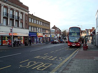
Bexleyheath is a town in south-east London, England, located in the London Borough of Bexley. It had a population of 31,929 as at 2011. Bexleyheath is located 12 miles (19.3 km) south-east of Charing Cross. It is identified in the London Plan as one of 35 major centres in London. Its wider definition is that of a small post town that takes in other surrounding neighbourhoods, including Barnehurst, much of West Heath and the former hamlet of Upton.

<span class="mw-page-title-main">Erith</span> Town in England

Erith is an area in south-east London, England, 13.3 miles (21.4 km) east of Charing Cross. Before the creation of Greater London in 1965, it was in the historical county of Kent. Since 1965 it has formed part of the London Borough of Bexley. It lies north-east of Bexleyheath and north-west of Dartford, on the south bank of the River Thames.

<span class="mw-page-title-main">Sidcup</span> Human settlement in England

Sidcup is an area of south-east London, England, primarily in the London Borough of Bexley. It is 11.3 miles (18.2 km) south-east of Charing Cross, bordering the London Boroughs of Bromley and Greenwich. Before the creation of Greater London in 1965, it was in the historical county of Kent.

<span class="mw-page-title-main">London Borough of Bexley</span> London borough in United Kingdom

The London Borough of Bexley is a London borough in south-east London, forming part of Outer London. It has a population of 248,287. The main settlements are Sidcup, Erith, Bexleyheath, Crayford, Welling and Old Bexley. The London Borough of Bexley is within the Thames Gateway, an area designated as a national priority for urban regeneration. The local authority is Bexley London Borough Council.

<span class="mw-page-title-main">Bexley</span> Human settlement in England

Bexley is an area of south-eastern Greater London, England and part of the London Borough of Bexley. It is sometimes known as Bexley Village or Old Bexley to differentiate the area from the wider borough. It is located 13 miles (21 km) east-southeast of Charing Cross and south of Bexleyheath.

<span class="mw-page-title-main">Foots Cray</span> Human settlement in England

Foots Cray is an area of South East London, England, within the London Borough of Bexley. Prior to 1965 it was in the historic county of Kent. It is located south-east of Sidcup, north of Orpington and north west of Swanley.

<span class="mw-page-title-main">River Cray</span> River

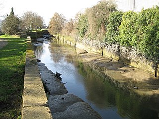
The River Cray is the largest tributary of the River Darent. It is the prime river of outer, south-east Greater London, rising in Priory Gardens, Orpington, where rainwater percolates through the chalk bedrock of the Downs to form a pond where the eroded ground elevation gives way to impermeable clay. Initially it flows true to form northwards, past industrial and residential St Mary Cray, through St Paul's Cray and through Foots Cray, where it enters the parkland Foots Cray Meadows, flowing under by Five Arches bridge. It then flows by restored Loring Hall (c.1760), home of the Lord Castlereagh who killed himself there in 1822. It continues through North Cray and Bexley. It neighbours a restored Gothic (architecture) cold plunge bath house, built around 1766 as part of Vale Mascal Estate. It is then joined by the River Shuttle and then continues through the parkland of Hall Place, which was built for John Champneys in 1540. The Cray turns eastward through Crayford and Barnes Cray to join the Darent in Dartford Creek. The Creek is a well-watered partly tidal inlet between Crayford Marshes and Dartford Marshes by a slight projection of land, Crayford Ness. The villages through which the Cray flows are collectively known as "The Crays".

<span class="mw-page-title-main">Dartford</span> Human settlement in England

Dartford is the principal town in the Borough of Dartford, Kent, England. It is located 18 mi (29 km) south-east of Central London and is situated adjacent to the London Borough of Bexley to its west. To its north, across the Thames estuary, is Thurrock in Essex, which can be reached via the Dartford Crossing. To its east lies the Borough of Gravesham and to the south the district of Sevenoaks.

<span class="mw-page-title-main">Bexleyheath line</span>

The Bexleyheath line runs for 8 miles (13 km) from Lewisham to Dartford in Kent. It separates from the North Kent Line just to the east of Blackheath Station, and rejoins the same line just south of Slade Green near Dartford.

<span class="mw-page-title-main">Dartford Loop Line</span> Railway line in the UK

The Dartford Loop Line is one of three lines linking London with Dartford in Kent, England. It lies to the south of the other two: the North Kent Line and the Bexleyheath Line.

<span class="mw-page-title-main">Barnehurst</span> Human settlement in England

Barnehurst is a town and electoral ward in South East London within the London Borough of Bexley. It lies north east of Bexleyheath, and 13.0 miles (20 km) east south-east of Charing Cross. It is separated from North Bexleyheath by the A220, Erith Road.

<span class="mw-page-title-main">Barnes Cray</span> Human settlement in England

Barnes Cray is an area in south-east London within the London Borough of Bexley. It is located on the Greater London border with Kent, bordering the Dartford Borough. It is located north west of Dartford.

<span class="mw-page-title-main">Wilmington, Kent</span> Human settlement in England

Wilmington is a village and civil parish in the Borough of Dartford in Kent, England. It is located 2.7 miles south of Dartford, 3.5 miles north of Swanley and 4.3 miles south east of Bexleyheath, adjacent to the Kent border with Greater London.

<span class="mw-page-title-main">Slade Green</span> Human settlement in England

Slade Green is an area of South East London, England, within the London Borough of Bexley. It lies northeast of Bexleyheath, northwest of Dartford and south of Erith, and 14 miles (23 km) east-southeast of Charing Cross.

The London Borough of Bexley owns and maintains over 100 parks and open spaces within its boundaries, with a total of 638 hectares. They include small gardens, river and woodland areas, and large parks with many sporting and other facilities.

<span class="mw-page-title-main">Joyden's Wood</span>

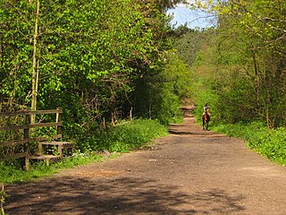
Joyden's Wood is an area of ancient woodland that straddles the border between the London Borough of Bexley in South East London and the Borough of Dartford in Kent, England. It is located 2.7 miles (4.3 km) north west of Swanley, 3.3 miles (5.3 km) south east of Bexleyheath and 3.6 miles (5.8 km) south west of Dartford. It is one of over 1,000 woodlands in the United Kingdom looked after by the Woodland Trust. The first records of a wood on this site go back to the year 1600. It is also the name of a housing estate to the east of the woodland itself.

Ruxley is a rural settlement of South East London, England that straddles the boundary of the London Boroughs of Bromley and Bexley. It is located 13 miles southeast of Charing Cross, the traditional centre of London, in the Metropolitan Green Belt between Sidcup and Swanley and is also adjacent to the Greater London border with the county of Kent.

<span class="mw-page-title-main">North Cray</span> Human settlement in England

North Cray is an area in South East London, England, within the London Borough of Bexley. It is located east of Sidcup and south of Bexleyheath and is 12.6 miles (20.3 km) south-east of Charing Cross, the traditional centre of London in the Metropolitan Green Belt.

Cresheld Draper was an English politician who sat in the House of Commons from 1678 to 1689.

References

  1. "Bexley Ward population 2011". Neighbourhood Statistics. Office for National Statistics. Archived from the original on 21 October 2016. Retrieved 14 October 2016.
  2. Brayley, Edward Wedlake (1808). The Beauties of England and Wales; or, Original Delineations Topographical, Historical and Descriptive of Each Country. Vol.VII. London: Thomas Maiden Sherbourn-Lane. p. 550. Retrieved 9 March 2019.
  3. Schofield, John (1999). The Building of London: From the Conquest to the Great Fire (3 ed.). Sutton. p. 21. ISBN   0750921838 . Retrieved 8 August 2018.
  4. Domesday Map Archived 20 February 2015 at the Wayback Machine Retrieved 2013-08-23
  5. 1 2 'Pigots 1840', on website freepages.genealogy.rootsweb.com/~shebra/pigots_1840 accessed 5 December 2007
  6. British History Online version of Edward Hasted's History of Kent Volume 2 accessed 10 February 2016
  7. History of Parliament page on Francis Goldsmith accessed 10 February 2016
  8. History of Parliament article on Cresheld Draper accessed 10 February 2016
  9. 1 2 Facets of Froyle website articles on the Draper family accessed 10 February 2016
  10. 1 2 Historic England assessmengt of Crayford Manor House Archived 7 February 2016 at the Wayback Machine accessed 7 February 2016
  11. Parks & Gardens website page on Shenstone Park Archived 8 February 2016 at the Wayback Machine accessed 7 February 2016
  12. 1 2 Dartford Council website article on Hiram Maxim Accessed 7 February 2016
  13. Bexley Boroughs Photos website text accompanying picture of Stoneyhurst Convent High School accessed 9 February 2016
  14. Bexley Council article on Martens and Oakwood Archived 15 February 2016 at the Wayback Machine accessed 7 February 2016
  15. "Local List" (PDF). London Borough of Bexley. 1 November 2019. Archived (PDF) from the original on 23 October 2021. Retrieved 5 February 2022.
  16. CDS https://www.cds.coop/for-co-ops/co-op/craymill/
  17. Services, Good Stuff IT. "Crayford - UK Census Data 2011".
  18. Crayford Community Centre Archived 7 February 2016 at the Wayback Machine Your London Library; accessed 7 February 2016
  19. Sainsburys article on largest stores in England, Scotland and Wales Archived 3 March 2016 at the Wayback Machine J Sainsbury; accessed 7 February 2016
  20. Developer plans for new Crayford retail park Archived 7 February 2016 at the Wayback Machine Completely Retail
  21. "Crayford Arrows Sports Club: Football in the Community". Crayford Arrows FC. Archived from the original on 3 September 2006. Retrieved 26 October 2006.
  22. "Crayford Jujitsu Club". Europa Centre. Archived from the original on 4 May 2018. Retrieved 6 December 2018.
  23. "Acts2Church Crayford - A friendly, lively church in Crayford". Archived from the original on 6 November 2018. Retrieved 28 August 2019.
  24. "IDEAL HOMES:A HISTORY OF SOUTH-EAST LONDON SUBURBS" . Retrieved 9 April 2019.[ permanent dead link ]
  25. Crayford National Rail Enquiries
  26. "Semi Ajayi". 11v11. Retrieved 1 December 2015.
  27. Bexley Council article 'Crayford' Archived 21 January 2016 at the Wayback Machine accessed 7 February 2016
  28. McCrery, Nigel (2011). The Coming Storm: Test and First-Class Cricketers Killed in World War Two. Vol. 2nd volume. Pen and Sword. pp. 104–5. ISBN   978-1526706980.
  29. Clayburn Family website page about Thomas Claiborne Archived 26 June 2010 at the Wayback Machine accessed 10 February 2016
  30. Kent Island website history page Archived 4 March 2016 at the Wayback Machine accessed 10 February 2016
  31. Archives of Maryland biography of William Claiborne by Jennifer Copeland accessed 10 February 2016
  32. New Kent History Blog article on its establishment accessed 10 February 2016
  33. Chalk, Gary; Holley, Duncan; Bull, David (2013). All the Saints: A Complete Players' Who's Who of Southampton FC. Southampton: Hagiology Publishing. p. 78. ISBN   978-0-9926-8640-6.
  34. Rogues & Early Modern English Culture (University of Michigan Press, Craig Dionne & Steve Mentz, Editors ISBN   0-472-03177-5) page 106 shown at books.google.co.uk accessed 10 February 2016
  35. "Henry Nuttall". cricketarchive.com. Retrieved 25 November 2016.
  36. "Surnames beginning with P". London Borough of Bexley. Archived from the original on 20 December 2016. Retrieved 9 December 2016.
  37. CrayfordHistory website article about May Place Archived 27 August 2010 at the Wayback Machine accessed 7 February 2016
  38. Bexley Council website article on Hiram Maxim Archived 7 February 2016 at the Wayback Machine Accessed 7 February 2016
  39. 'A Remarkable Sporting Life' - article about Derek Ufton on Kent Cricket website accessed 10 February 2016
  40. Description of the Crayford Focuser Archived 10 October 2007 at the Wayback Machine accessed 28 November 2007