
Bracklesham Bay is a 200.6-hectare (496-acre) biological and geological Site of Special Scientific Interest in West Sussex. It is a Geological Conservation Review site.
The Fur Formation is a marine geological formation of Ypresian age which crops out in the Limfjord region of Denmark from Silstrup via Mors and Fur to Ertebølle, and can be seen in many cliffs and quarries in the area. The Diatomite Cliffs is on the Danish list of tentative candidates for World Heritage and may become a world Heritage site.

Boxford Chalk Pit is a 0.4-hectare (0.99-acre) geological Site of Special Scientific Interest in Boxford in Berkshire. It is a Geological Conservation Review site.

Southerham Grey Pit is a 8.5-hectare (21-acre) geological Site of Special Scientific Interest south-east of Lewes in East Sussex. It is a Geological Conservation Review site.

Lesnes Abbey Woods, sometimes known as Abbey Wood, is a 73 ha ancient woodland in southeast London, England. It is located near to, and named after, the ruined Lesnes Abbey in the London Borough of Bexley and gives its name to the Abbey Wood district. The woods are adjacent to Bostall Woods.
Strathcona Fiord is a fiord on the west central coast of Ellesmere Island, the most northern island within the Arctic Archipelago, Nunavut, Canada.
Elmstead Pit is a geological Site of Special Scientific Interest in Elmstead in the London Borough of Bromley. Formerly known as Rock Pits, it is a small area of 0.05 hectare. It is a Geological Conservation Review site.

Gilbert's Pit is a 5.2-hectare (13-acre) geological Site of Special Scientific Interest in Charlton in the Royal Borough of Greenwich. It was notified in 1985 and was formerly known as Charlton Sand Pit. It is a Geological Conservation Review site. It is also part of the Maryon Wilson Park and Gilbert's Pit Local Nature Reserve. It adjoins Maryon Park and is close to Maryon Wilson Park.

The Bridger Formation is a geologic formation in southwestern Wyoming. It preserves fossils dating back to the Ypresian Epoch of the Paleogene Period. The formation was named by American geologist Ferdinand Vandeveer Hayden for Fort Bridger, which had itself been named for mountain man Jim Bridger. The Bridger Wilderness covers much of the Bridger Formation's area.

The Cliff, Burnham-on-Crouch is a 4 hectare geological Site of Special Scientific Interest (SSSI) on the bank of the River Crouch between Burnham-on-Crouch and North Fambridge in Essex. It is also part of the biological SSSI, Crouch and Roach Estuaries. It is a Geological Conservation Review site both for its fossil birds and for its fishes and amphibians.

Harwich Foreshore is a 10.6-hectare (26-acre) geological Site of Special Scientific Interest in Harwich in Essex. It is a Geological Conservation Review site.
The Naze SSSI is a 22 hectare geological Site of Special Scientific Interest on The Naze peninsula north of Walton-on-the-Naze in Essex. It is a Geological Conservation Review site both for its Pleistocene fossils and for its birds. It is part of The Naze Nature Reserve, which is managed by the Essex Wildlife Trust.
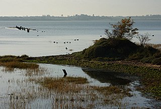
Stour Estuary is a 2,523 hectare biological and geological Site of Special Scientific Interest which stretches from Manningtree to Harwich in Essex and Suffolk. It is also an internationally important wetland Ramsar site, a Special Protection Area and a Nature Conservation Review site. It is part of the Suffolk Coast and Heaths Area of Outstanding Natural Beauty, and there are Geological Conservation Review sites in Wrabness, Stutton, and Harwich Part of the site is managed by the Royal Society for the Protection of Birds, and a small area is Wrabness Nature Reserve, a Local Nature Reserve managed by the Essex Wildlife Trust.
Sandwich Bay to Hacklinge Marshes is a 1,790.1-hectare (4,423-acre) biological and geological Site of Special Scientific Interest which stretches between Deal and Sandwich in Kent. It includes two Geological Conservation Review sites, and most of it is a Nature Conservation Review site, Grade I. Part of it is a Ramsar site, a Special Area of Conservation, a Special Protection Area and a National Nature Reserve, It also includes a Kent Wildlife Trust nature reserve and a Local Nature Reserve,

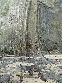
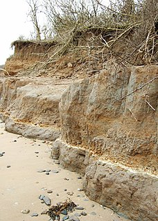
Sheppey Cliffs and Foreshore is a 303.6-hectare (750-acre) biological and geological Site of Special Scientific Interest which stretches between Minster and Leysdown-on-Sea in Kent. It includes five Geological Conservation Review sites. This site exposes Eocene London Clay with well-preserved fossil fauna and flora, which have been studied since the eighteenth century.
Tower Hill to Cockham Wood is a 47.8-hectare (118-acre) biological and geological Site of Special Scientific Interest on the northern outskirts of Rochester in Kent. It contains two Geological Conservation Review sites.

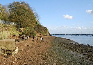
Bognor Reef is a 39.7-hectare (98-acre) biological and geological Site of Special Scientific Interest which stretches along the foreshore of Bognor Regis in West Sussex. It is a Geological Conservation Review site.

Kirtlington Quarry is a 3.1-hectare (7.7-acre) geological Site of Special Scientific Interest west of Kirtlington in Oxfordshire. It is a Geological Conservation Review site, and it is part of the 7.4-hectare (18-acre) Kirtlington Quarry Local Nature Reserve.
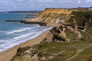
Highcliffe to Milford Cliffs is a 110.1-hectare (272-acre) geological Site of Special Scientific Interest which stretches along the south coast of England from Christchurch in Dorset to Milford on Seain Hampshire. It includes several Geological Conservation Review sites.

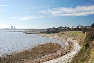
Lee-on-The Solent to Itchen Estuary is a 585.9-hectare (1,448-acre) biological and geological Site of Special Scientific Interest which stretches along the coast between Southampton and Gosport in Hampshire. It is a Geological Conservation Review site. It is part of Solent and Southampton Water Ramsar site and Special Protection Area, and of Solent Maritime Special Area of Conservation. Three areas are Local Nature Reserves, Chessel Bay, Hook with Warsash and Mercury Marshes. One area is Hamble Common Camp, a Scheduled Monument.

