The London Borough of Havering in East London, England, forms part of Outer London. It has a population of 259,552 inhabitants; the principal town is Romford, while other communities are Hornchurch, Upminster, Collier Row and Rainham. The borough is mainly suburban, with large areas of protected open space. Romford is a major retail and night time entertainment centre, and to the south the borough extends into the London Riverside redevelopment area of the Thames Gateway. The name Havering is a reference to the Royal Liberty of Havering which occupied the area for several centuries. The local authority is Havering London Borough Council. It is the easternmost London borough.

The North Kent Marshes are in the far north of the county of Kent spanning dry and wet south banks and inlets of the Thames Estuary in south-east England. The marshes are one of 22 Environmentally Sensitive Areas recognised by the UK's Department for Environment, Food and Rural Affairs (DEFRA). They are in the Thames Gateway regional planning area. They include the 5,289-hectare (20.4 sq mi) South Thames Estuary and Marshes biological SSSI.
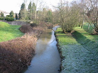
The River Ingrebourne is a tributary of the River Thames 27 miles (43.3 km) in length. It is considered a strategic waterway in London, forming part of the Blue Ribbon Network. It flows through the London Borough of Havering roughly from north to south, joining the Thames at Rainham.
Hornchurch Country Park is a 104.5-hectare park on the former site of Hornchurch Airfield, south of Hornchurch in the London Borough of Havering, east London.

The Hoo Peninsula is a peninsula in Kent, England, separating the estuaries of the rivers Thames and Medway. It is dominated by a line of chalk, clay and sand hills, surrounded by an extensive area of marshland composed of alluvial silt. The name Hoo is a Saxon word believed to mean 'spur of land' or refers to the 'distinct heel-shape of the ridge of hills' through Hoo. Hoo features in the Domesday Book. The peninsula is home to internationally and nationally protected wildlife sites as well as industrial facilities and energy industries.

Wennington is a small village in the London Borough of Havering, in east London. It is situated 14.8 miles east of Charing Cross. Wennington was an ancient parish in the county of Essex that was abolished for civil purposes in 1934. It is peripheral to London, forming a ribbon development extending from the eastern edge of the urban sprawl and surrounded by the Metropolitan Green Belt. Wennington was added to Hornchurch Urban District in 1934 and has formed part of Greater London since 1965.

Insh Marshes are an area of floodplain of the River Spey between Kingussie and Kincraig in Badenoch and Strathspey, Highland, Scotland. The marshes are said to be one of the most important wetlands in Europe. They lie at altitude of approximately 240 to 220 m above sea level, and form one of the largest areas of floodplain mire and fen vegetation in Scotland.
The Wildspace Conservation Park, also known as London Riverside Conservation Park or Wildspace, is a major new conservation park under development. The conservation park is predominantly in London, within the London Borough of Havering, but also extends across the capital's administrative boundary and into Thurrock in Essex. It covers much of the land adjacent to the River Thames near to Rainham and Wennington. The RSPB nature reserve is the largest part of the park to be open to the public. Later phases include the reuse of a large landfill site as parkland.

Mucking Marshes landfill was a major landfill site servicing London, close to the hamlet of Mucking. Covering hundreds of acres of former gravel quarry, it was one of the largest landfills in Western Europe and had been filled for decades with municipal and commercial waste floated thirty miles down the River Thames in barges to Mucking Wharf. The barges, each carrying dozens of distinctive yellow containers, were a familiar, though rarely commented-upon, sight along the Thames through Central London. Once the barges had travelled 30 miles (48 km) downstream from Walbrook Wharf, mechanical cranes at Mucking Wharf unloaded the containers onto trucks. The trucks made their way up the artificial mound created by decades of garbage compaction that still towers over the surrounding flat landscape. Flocks of seagulls and other scavenging estuarine birds were a familiar sight as the trucks disgorged their contents.

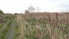
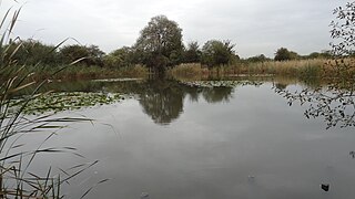
Ingrebourne Marshes are a 74.8 hectare biological Site of Special Scientific Interest in Hornchurch in the London Borough of Havering. Ingrebourne Valley Local Nature Reserve includes a small part of the SSSI west of the River Ingrebourne. The site is managed by the Essex Wildlife Trust

Rye Meads is a 58.5-hectare (145-acre) biological Site of Special Scientific Interest (SSSI) in Rye House, Hoddesdon, Hertfordshire. It is one of series of wetlands and reservoirs situated along the River Lea, to the north-east of London. It is part of the Lea Valley Ramsar site and a Special Protection Area.
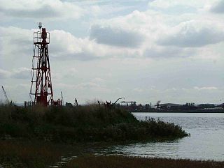
Coldharbour is an area of the London Borough of Havering by the River Thames and southwest of the Rainham Marshes Nature Reserve. It is the location of Coldharbour Point, where there has been a lighthouse since 1885. This point is adjacent to the town of Erith in Bexley, across the Thames. The nearest accessible settlement on land is the town of Rainham, which is connected by Coldharbour Lane; the village of Wennington is also nearby but not accessible by road. The area around the point is mainly industrial land known as the Freightmaster Estate depot. The London Loop passes through Coldharbour on its way east to Purfleet in Thurrock.

Rainham is a suburb of East London, England, in the London Borough of Havering. Historically an ancient parish in the county of Essex, Rainham is 13.6 miles (21.9 km) east of Charing Cross and is surrounded by a residential area, which has grown from the historic village, to the north and a commercial area, fronting the River Thames, to the south. As part of the suburban growth of London in the 20th century, Rainham significantly expanded and increased in population, becoming part of Hornchurch Urban District in 1934, and has formed part of Greater London since 1965. The economic history of Rainham is underpinned by a shift from agriculture to industry and manufacture and is now in a period of regeneration, coming within the London Riverside section of the Thames Gateway redevelopment area.

van Heyningen and Haward is an architectural practice, founded in 1983 by Birkin Haward and Joanna van Heyningen, and now owned and managed by James McCosh and Meryl Townley. The London architects work primarily in education, and have also worked in the heritage, community and health sectors.
Pitsea waste management site is a large landfill site on the north side of the Thames estuary 0.7 miles (1.1 km) from Pitsea in Basildon, Essex. It is the second largest landfill site in the UK operated by Veolia Ltd. receiving 800,000 tonnes of solid waste per year, mostly from the London conurbation.
Thurrock Thameside Nature Park is an Essex Wildlife Trust nature reserve located on top of the former Mucking Marshes Landfill in Thurrock, England which will eventually cover 845 acres (342 ha). It is next to the River Thames and provides good bird and ship watching. The Cory Environmental Trust Visitor Centre is located at the preserve and provides a roof top viewing platform.

Cranham Marsh is a 15.3 hectare Local Nature Reserve and a Site of Metropolitan Importance for Nature Conservation in Cranham in the London Borough of Havering. It is owned by Havering Council and managed by the Essex Wildlife Trust.
The Chase is a nature reserve in Dagenham in London. Most of it is in the London Borough of Barking and Dagenham, with a small part in Havering. It is owned by the boroughs, and managed by London Borough of Barking & Dagenham - Parks & Countryside Ranger Service. The boroughs have designated the sections in their respective boroughs as Local Nature Reserves. The Chase, together with the neighbouring Eastbrookend Country Park, is also designated a Site of Metropolitan Importance for Nature Conservation.