Coldfall Wood

Last updated
Shadows in Coldfall Wood Shadows in Coldfall wood.jpg
Shadows in Coldfall Wood

Coldfall Wood is an ancient woodland in Muswell Hill, North London. It covers an area of approximately 14 hectares (35 acres) and is surrounded by St Pancras and Islington Cemetery, the East Finchley public allotments, and the residential streets Creighton Avenue and Barrenger Road. It is the site of the discoveries which first led to the recognition that glaciation had once reached southern England. It was declared a local nature reserve in 2013, [1] and is also a Site of Borough Importance for Nature Conservation, Grade 1. [2] [3]

Contents

History

Southern entrance to Coldfall Wood Coldfall Wood South Entrance.JPG
Southern entrance to Coldfall Wood

The London Borough of Haringey contains four ancient woods: Highgate Wood, Queen's Wood, Coldfall Wood, and Bluebell Wood. [4] All are shown on John Rocque's 1754 Map of Middlesex.[ citation needed ]

Until the early 20th century Coldfall Wood was more than twice its current size, reaching south to the properties bordering Fortis Green. [5] The southern section was felled and partially excavated for gravel, before being used for residential development and the sites of Tollington and William Grimshaw schools (later Fortismere School). Tollington first rented and felled part of the wood for a sports field in the 1920s [6] and subsequently moved to a new building on the site. William Grimshaw was built later to the north.

Coldfall Wood was purchased in 1930 by Hornsey Council and the remaining section is now owned and managed by its successor, the London Borough of Haringey. It is bounded to the north by St Pancras and Islington Cemetery and Muswell Hill Sports Ground (formerly Finchley Common). Its western boundary is the boundary line between the London Boroughs of Barnet and Haringey. This western boundary and its northern boundaries are demarcated by the remains of an ancient woodbank with a ditch on the outer side. This would have prevented grazing animals from the surrounding Finchley Common and Horseshoe Farm (as they then were) from entering the wood and destroying the young coppice.

Coldfall Wood has been examined in some detail by Silvertown (1978), who used historical sources to show that the woodlands are likely to be of primary origin (i.e. continuously present since prehistoric times). [7]

In March 2011, the Friends of Coldfall Wood launched an online interactive map that included historical maps of the area overlaid on a modern streetmap, showing how the wood has dwindled in size since 1864.

Flora

The absence of foliage on this blasted oak lets light through to the woodland floor. Coldfall Wood Blasted Oak.JPG
The absence of foliage on this blasted oak lets light through to the woodland floor.

Like the other local ancient woodlands in the area, the wood is dominated by oak standards, but the understorey is much less diverse and consists of almost pure stands of multi-stemmed, overgrown hornbeam coppice. Beech, hazel, mountain ash and wild service tree are all rare, though there are some fine specimens of the last species.

Hornbeam understorey Coldfall Wood Hornbeam Undercanopy.JPG
Hornbeam understorey

Little light penetrates to the woodland floor in the most wooded places and large areas of the wood are devoid of either shrub, field or ground layers of vegetation. Consequently, parts of the wood can present a dark and gloomy appearance in the summer months. Nevertheless, in the few glade areas, caused by the collapse of an occasional canopy tree, or by more recent coppicing, the flora is of considerable interest. Pill sedge hangs on in its only known Haringey site, and tiny populations of cow-wheat, slender St John's wort, wood anemone, and heath speedwell manage to survive, though they seldom flower.

An area of approximately one acre was cut in the north-western corner of the wood in December 1990 with the assistance of the British Trust for Conservation Volunteers, the Friends of Coldfall Wood, and the Haringey Branch of the London Wildlife Trust. The felled hornbeam poles were cut, stacked on site, and allowed to decay in situ to provide deadwood habitat for the benefit of invertebrates and fungi. Brushwood was used to construct a dead hedge around the coppice. This has protected the area from trampling, both by dogs and humans, and will hopefully provide a nesting habitat for wrens and other woodland birds. Regrowth from the cut hornbeam stools has been encouraging with a maximum growth of two metres being recorded by the end of 1991.

The vegetational succession following the coppice is being carefully monitored by means of permanent quadrats. In the first year after coppicing, more than seventy species of flowering plant have been recorded here – a gratifying increase from the original flora of a mere six species. The newcomers include heath groundsel, which is unknown elsewhere in the Borough, suggesting the possibility that its seed may have lain dormant in the soil since the last coppice was cut before the Second World War. Ring counts of the coppice poles suggest that this was done about sixty years ago. The majority of new plants, however, will have colonised from outside and many of the arrivals are widespread ruderal species typical of disturbed open habitats, such as mugwort, sow-thistles and willowherbs. Rosebay willowherb dominates much of the area. A hundred years ago this was a rare plant in southern England and it was recorded from Coldfall Wood as early as 1901 (Kent 1975). The appearance of Sumatran fleabane was not entirely unexpected, for it has spread rapidly throughout Haringey since first being recorded from the Borough in 1985 (Wurzell 1988). It is also present in North Wood. There can be few other ancient woods in Britain that include this subtropical species in their flora.

Geology

The wood lies on the northern margin of the glacial ridge that forms Muswell Hill. The surviving section of the wood lies on London Clay overlain by head. To the immediate west and south this is overlain by gravels of a former course of the Thames, capped by glacial till of Anglian age. [8] It was here in 1835 that N. T. Wetherell discovered a strange mixture of rocks and fossils normally found in the north of England that led to the subsequent recognition of glacial deposits in southern England. [9]

Improvements

Coldfall Wood was selected as one of six "Flagship Woods" in the whole of London, to be included as part of the "Capital Woodlands Project" application to the Heritage Lottery Fund (HLF) which was prepared by a range of partners, including the Greater London Authority, the Forestry Commission, and several London Boroughs including Haringey. The bid was taken forward by Trees for Cities.

The improvement programme consisted of the following projects, completed over a three-year period.

  1. Coppicing commenced in November 2006, and resulted in an increase of ferns and flowering plants from 48 to 156 species a year later. [10]
  2. Four new bridges were added. [11]
  3. Two new reed beds were created. [11]
  4. Sloping tarmac paths were added to improve access through the various entry gates, as well as welcome boards, notice boards, and interpretation panels. [11]

Related Research Articles

Highgate Human settlement in England

Highgate is a suburban area of north London at the northeastern corner of Hampstead Heath, 4.5 miles (7.2 km) north-northwest of Charing Cross.

Hornsey Area of London, England

Hornsey is a district of north London, England in the London Borough of Haringey. It is an inner-suburban, for the most part residential, area centred 10 km (6.2 mi) north of Charing Cross. It adjoins green spaces Queen's Wood and Alexandra Park to the north.

Muswell Hill Human settlement in England

Muswell Hill is a suburban district of north London. It is mainly in the London Borough of Haringey with a small part in the London Borough of Barnet. It is between Highgate, Hampstead Garden Suburb, East Finchley and Crouch End. It has many streets with Edwardian architecture.

London Borough of Haringey London borough in United Kingdom

The London Borough of Haringey is a London borough in North London, classified by some definitions as part of Inner London, and by others as part of Outer London. It was created in 1965 by the amalgamation of three former boroughs. It shares borders with six other London boroughs. Clockwise from the north, they are: Enfield, Waltham Forest, Hackney, Islington, Camden, and Barnet.

Crouch End Human settlement in England

Crouch End is an area of North London, approximately five miles (8 km) from the City of London in the western half of the borough of Haringey. It is within the Hornsey postal district (N8).

Harringay Human settlement in England

Harringay is a district of north London, England, within the London Borough of Haringey. It is centred on the section of Green Lanes running between the New River, where it crosses Green Lanes by Finsbury Park, and Duckett's Common, near Turnpike Lane.

Parkland Walk

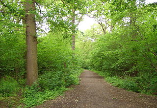
The Parkland Walk is a 3.1-mile (5.0 km) linear green pedestrian and cycle route in London, which follows the course of the railway line that used to run between Finsbury Park and Alexandra Palace, through Stroud Green, Crouch End, Highgate and Muswell Hill. It is often mistakenly described as 4.5 miles long, but even taking in the gap between the two sections it still only totals 3.1 miles (5.0km). The route follows the bridges and cuttings of the line, but avoids the closed surface section of Highgate station and its adjoining tunnels, which are closed to walkers for safety reasons. The walk is almost all in Haringey, but a short stretch between Crouch Hill and Crouch End Hill is in Islington and this section incorporates Crouch Hill Park.

Fortis Green Human settlement in England

Fortis Green is a ward in the extreme northwestern corner of the Borough of Haringey, north London. It is also the name of the road that runs between Muswell Hill and East Finchley which forms part of the A504.

Hornsey and Wood Green (UK Parliament constituency)

Hornsey and Wood Green is a constituency created in 1983 represented in the House of Commons of the UK Parliament since May 2015 by Catherine West, of the Labour Party. To date it has drawn together for general elections parts of the London Borough of Haringey.

Municipal Borough of Hornsey

Hornsey was a local government district in east Middlesex from 1867 to 1965.

Highgate Wood

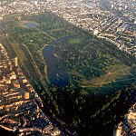
Highgate Wood is a 28 hectare area of ancient woodland in North London, lying between East Finchley, Highgate and Muswell Hill. It was originally part of the ancient Forest of Middlesex which covered much of London, Hertfordshire and Essex and was mentioned in the Domesday Book. It lies in the London Borough of Haringey, but is owned and managed by the City of London Corporation.

Hornsey was an ancient parish in the county of Middlesex. It was both a civil parish, used for administrative purposes, and an ecclesiastical parish of the Church of England.

Queens Wood 52-acre wood in Haringey, London

Queen's Wood is a 52-acre area of ancient woodland in the London Borough of Haringey, abutting Highgate Wood and lying between East Finchley, Highgate, Muswell Hill and Crouch End. It was originally part of the ancient Forest of Middlesex which covered much of London, Hertfordshire and Essex and was mentioned in the Domesday Book. It is now one of three Local Nature Reserves in the London Borough of Haringey. It is situated a few minutes' walk from Highgate tube station.

St Pancras and Islington Cemetery Cemetery in the London Borough of Barnet

St Pancras and Islington Cemetery in East Finchley, North London while situated in the London Borough of Barnet is actually two cemeteries, owned by two other London Boroughs, Camden and Islington. The fence along the boundary which runs west to east between the two parts of the cemetery has been removed, although the line of it is still marked.

A1 in London

The A1 in London is the southern part of the A1 road. It starts at Aldersgate in the City of London, passing through the capital to Borehamwood on the northern fringe of Greater London, before continuing to Edinburgh. The road travels through the City and three London boroughs: Islington, Haringey and Barnet, which include the districts of Islington, Holloway, Highgate, Hendon and Mill Hill, and travels along Upper Street and Holloway Road, crossing the North Circular Road in Hendon, a district in the London Borough of Barnet.

The history of Harringay tells the story of the development of the district of London five miles from its centre, affected by, but not always part of, the great city's history.

Cherry Tree Wood

Cherry Tree Wood is a 5.3-hectare park in East Finchley in the London Borough of Barnet. It is a Site of Local Importance for Nature Conservation. Located opposite East Finchley Underground station, it contains woodland and grassland, a playground, tennis courts, a cafe and toilets.

Scratchwood

Scratchwood is an extensive, mainly wooded, country park in Mill Hill in the London Borough of Barnet. The 57-hectare site is a Site of Metropolitan Importance for Nature Conservation and together with the neighbouring Moat Mount Open Space. It is a Local Nature Reserve.

Coppetts Wood and Scrublands Nature reserve in the London Borough of Barnet

Coppett's Wood and Scrublands is a 14.5 hectare Site of Borough Importance for Nature Conservation, Grade I, between Muswell Hill and Friern Barnet in the London Borough of Barnet. It is part of the Coppett's Wood and Glebelands Local Nature Reserve.

Big Wood and Little Wood

Big Wood and Little Wood are two patches of woodland in Hampstead Garden Suburb in the London Borough of Barnet. They are a Site of Borough Importance for Nature Conservation, Grade 1, and a Local Nature Reserve. Big Wood is 7.3 hectares and Little Wood is 1.2 hectares.

References

  1. "Coldfall Wood". Local Nature Reserves. Natural England. 20 March 2014. Retrieved 9 April 2014.
  2. "Coldfall Wood". Greenspace Information for Greater London. 2013. Archived from the original on 13 April 2014. Retrieved 9 April 2014.
  3. "iGiGL data portal (map)". Greenspace Information for Greater London. Archived from the original on 14 January 2014. Retrieved 9 April 2014.
  4. "Ancient Woodlands". Haringey Council. Archived from the original on 27 May 2011. Retrieved 20 June 2010.
  5. Ordnance Survey 1:2500 map of 1894, Republished as London Sheet 11: Muswell Hill 1894, The Godfrey Edition, Gateshead: Alan Godfrey Maps, 1985, ISBN   0-85054-006-2
  6. "A Short History of Tollington School Part One 1879-1928". Old Tollingtonians Society. Archived from the original on 2011-07-17. Retrieved 2010-10-04.
  7. Silvertown, Jonathan (1978), "The history of woodlands in Hornsey", London Naturalist, 57: 11–25.
  8. Sheet 256 North London, 1:50,000 Geology Series, Keyworth: British Geological Survey, 2006, ISBN   0-7518-3427-0
  9. Walker, H. (1874),The Glacial Drifts of Muswell Hill & Finchley, reprinted 1993, London: Jack Whitehead
  10. "Woodland Management in London" (PDF). Greenspace Information for Greater London. Retrieved 9 May 2019.
  11. 1 2 3 "Coldfall Wood Management Plan 2012" (PDF). Haringey, London. Retrieved 9 May 2019.

Coordinates: 51°35′49″N00°09′33″W / 51.59694°N 0.15917°W / 51.59694; -0.15917