The London Borough of Southwark in south London forms part of Inner London and is connected by bridges across the River Thames to the City of London and London Borough of Tower Hamlets. It was created in 1965 when three smaller council areas amalgamated under the London Government Act 1963. All districts of the area are within the London postal district. It is governed by Southwark London Borough Council.

Dulwich is an area of south London, England. The settlement is mostly in the London Borough of Southwark, with parts in the London Borough of Lambeth, and consists of Dulwich Village, East Dulwich, West Dulwich, and the Southwark half of Herne Hill. Dulwich lies in a valley between the neighbouring districts of Camberwell, Crystal Palace, Denmark Hill, Forest Hill, Peckham, Sydenham Hill, and Tulse Hill.

Sydenham is a district of south-east London, England, which is shared between the London boroughs of Lewisham, Bromley and Southwark. Prior to the creation of the County of London in 1889, Sydenham was located in Kent, bordering Surrey. Historically, the area was very affluent, with the Crystal Palace being relocated to Sydenham Hill in 1854. Today, Sydenham is a diverse area, with a population of 28,378 and borders Forest Hill, Dulwich, Crystal Palace, Penge, Beckenham, Catford and Bellingham.

East Dulwich is an area of South East London, England in the London Borough of Southwark. It forms the eastern part of Dulwich, with Peckham to the east and Camberwell to the north. This South London suburb was first developed in the nineteenth century on land owned by the College of God's Gift.

Camberwell was a civil parish and metropolitan borough in south London, England. Camberwell was an ancient parish in the county of Surrey, governed by an administrative vestry from 1674. The parish was included in the area of responsibility of the Metropolitan Board of Works in 1855 and became part of the County of London in 1889. The parish of Camberwell became a metropolitan borough in 1900, following the London Government Act 1899, with the parish vestry replaced by a borough council. In 1965 the borough was abolished and its former area became part of the London Borough of Southwark in Greater London.

Lordship Lane is an ancient thoroughfare, once rural, in East Dulwich, a suburb of the London Borough of Southwark in southeast London, England, and forms part of the A2216.

The South East London Green Chain, also known as the Green Chain Walk, is a linked system of open spaces between the River Thames and Crystal Palace Park in London, England. In 1977 four London boroughs and the Greater London Council created this Green Chain of 300 open spaces to protect them from building activity. The four London boroughs are Bexley, Bromley, Lewisham and Greenwich. More recently it has been extended to include sections in Southwark. Many parts of the system are also part of the Capital Ring route.

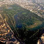
The London Borough of Southwark, occupying a roughly triangular area south of Tower Bridge over the River Thames, considers itself to be one of the greenest boroughs in London, with its 245 hectares of public parkland. There are more than 130 such green areas, ranging from the large areas around Dulwich and Southwark Park in Rotherhithe to the many sports grounds and squares. The main ones are:

Bermondsey Abbey was an English Benedictine monastery. Most widely known as an 11th-century foundation, it had a precursor mentioned in the early eighth century, and was centred on what is now Bermondsey Square, the site of Bermondsey Market, Bermondsey, in the London Borough of Southwark, southeast London, England.

Gipsy Hill in south London is a hilly neighbourhood spanning the southern parts of the London Boroughs of Lambeth and Southwark characterised for its great views of the City of London and Dulwich.

London Wildlife Trust (LWT), founded in 1981, is a local nature conservation charity for Greater London. It is one of 46 members of the Royal Society of Wildlife Trusts, each of which is a local nature conservation charity for its area. The Trust aims to protect London's wildlife and wild spaces, and it manages over 40 nature reserves in Greater London. One of its campaigns is to turn London's gardens into mini-nature reserves, and it provides education services for schools. Local groups work on reserves and organise walks.

West Dulwich is an area in south London, England, which straddles the London Borough of Lambeth and the London Borough of Southwark. Croxted Road and South Croxted Road mark the boundary between Southwark to the east and Lambeth to the west. The suburb of West Dulwich dates back to the 17th century when the often flooded land known as Dulwich Common was acquired and drained by Edward Alleyn's estate.
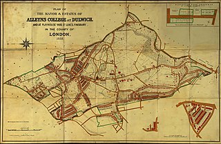
The Dulwich Estate, previously the Estates Governors of Alleyn's College of God's Gift at Dulwich, is a registered charity in England, one of the successors to the historic charity Edward Alleyn's College of God's Gift that was founded in 1619. It owns the freehold of around 1,500 acres (6.1 km2) in Dulwich, South London, including a number of private roads and a tollgate. The estate properties range from Regency and 19th century buildings to distinguished modernist 1960s buildings.

Sydenham Hill forms part of a longer ridge and is an affluent locality in southeast London. It is also the name of a road which runs along the northeastern part of the ridge, demarcating the London Boroughs of Southwark, Bromley, and Lewisham. Its highest part is the apex of the Boroughs of Southwark and Lewisham and the 15th-highest peak in London, at 367 feet (112 m).

The Great North Wood was a natural oak woodland that started three miles (4.8 km) south-east of central London and scaled the Norwood Ridge. At its full extent, the wood's boundaries stretched almost as far as Croydon and as far north as Camberwell. It had occasional landownings as large clearings, well-established by the Middle Ages such as the hamlets of Penge and Dulwich.

Lordship Lane was a railway station in East Dulwich, in what was the Metropolitan Borough of Camberwell in south London, on the Crystal Palace and South London Junction Railway. It was opened by the London, Chatham and Dover Railway (LCDR) in September 1865 and took its name from Lordship Lane, the thoroughfare on which it stood. It was situated a short distance from a rival London, Brighton and South Coast Railway (LBSCR) station named Forest Hill, which survives.

Sydenham Hill Wood is a ten-hectare wood on the northern slopes of the Norwood Ridge in the London Borough of Southwark. It is designated as a Local Nature Reserve and Site of Metropolitan Importance for Nature Conservation. With the adjacent Dulwich Wood, Sydenham Hill Wood is the largest extant tract of the ancient Great North Wood. The two woods are formed from coppices known as Lapsewood, Old Ambrook Hill Wood and Peckarmans Wood after the relocation of The Crystal Palace in 1854 and the creation of the high level line in 1865.

Dulwich Upper Wood is a 2.4 hectare local nature reserve and Site of Borough Importance for Nature Conservation, Grade 1, in Crystal Palace in the London Borough of Southwark. It is owned by Southwark Council and managed by the Trust for Urban Ecology.