
The London Borough of Hounslow is a London borough in West London, England, forming part of Outer London. It was created in 1965 when three smaller borough councils amalgamated under the London Government Act 1963. It is governed by Hounslow London Borough Council.
Hornchurch Country Park is a 104.5-hectare park on the former site of Hornchurch Airfield, south of Hornchurch in the London Borough of Havering, east London.
Pyl Brook is a small stream in southwest London. It is a tributary of Beverley Brook, which is a tributary of the River Thames. Pyl Brook has two sources. The 5.3 kilometre main brook rises in Sutton Common in Sutton and flows through the London Borough of Merton to join Beverley Brook at Beverley Park in New Malden. The 3.9 kilometre East Pyl Brook also rises in Sutton and flows through Merton, joining the main Pyl east of Grand Drive in Raynes Park.

The London Borough of Hounslow is a peripheral London borough in the south-west of the conurbation; as such part of the Metropolitan Green Belt lies within its boundaries. It has one of London's largest Nature reserves as well as many smaller gardens and sports grounds. The major areas are:

Eastbrookend Country Park is an 84-hectare park and Local Nature Reserve in Dagenham in the London Borough of Barking and Dagenham, in England. Together with the neighbouring Chase Nature Reserve it is also designated a Site of Metropolitan Importance for Nature Conservation.

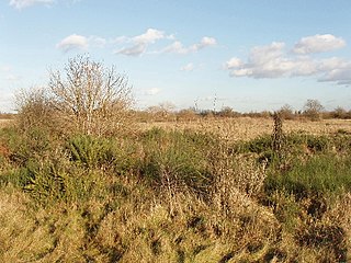
Ingrebourne Valley is a local nature reserve (LNR) in Hornchurch in the London Borough of Havering. It is owned and managed by Havering Council, and has a visitor centre managed by the Essex Wildlife Trust. Most of it is in Hornchurch Country Park west of the River Ingrebourne, but there are also areas north and south of the park which are part of the LNR. It has a wide range of habitats, including woodland, grassland, the river and marshes. It is an important site for a range of species of plants, animals and birds, including great crested newts, slow worms, the harvest mouse and the water vole.
Hounslow Heath is a local nature reserve in the London Borough of Hounslow and at a point borders Richmond upon Thames. The public open space, which covers 200 acres (80 ha), is all that remains of the historic Hounslow Heath which covered more than 4,000 acres (1,600 ha). The present day area is bounded by A315 Staines Road, A3063 Wellington Road South, A314 Hanworth Road, and the River Crane.

Totteridge Fields is a 97-hectare Site of Metropolitan Importance for Nature Conservation (SINC) in Totteridge in the London Borough of Barnet. The SINC includes the privately owned Highwood Hill, and at the western end is a seven-hectare Local Nature Reserve owned by Barnet Council and managed by the London Wildlife Trust.

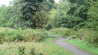
Scratchwood is an extensive, mainly wooded, country park in Mill Hill in the London Borough of Barnet. The 57-hectare site is a Site of Metropolitan Importance for Nature Conservation and together with the neighbouring Moat Mount Open Space. It is a Local Nature Reserve.

Jubilee Country Park is a 62-acre (25 ha) public park in Petts Wood in the London Borough of Bromley. It is a Local Nature Reserve and a Site of Metropolitan Importance for Nature Conservation. It was purchased by Bromley Council to celebrate the Silver Jubilee of Queen Elizabeth II in 1977, and opened as a park in 1981.

Crane Park Island is a Local Nature Reserve in Twickenham in the London Borough of Richmond upon Thames. It is also part of The Crane Corridor Site of Metropolitan Importance for Nature Conservation. The site is an island in the River Crane, which is owned by Richmond upon Thames London Borough Council and managed by the London Wildlife Trust. The (only) entrance is next to the Shot Tower in Crane Park.
Crane Park is a 30 hectare public park next to the River Crane in western Twickenham. The park north of the river is in the London Borough of Richmond upon Thames, and the south in the London Borough of Hounslow. It is part of The Crane Corridor Site of Metropolitan Importance for Nature Conservation, and includes two Local Nature Reserves, Crane Park Island and Pevensey Road.

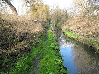
Cranebank is a Local Nature Reserve on the east bank of the River Crane in Hatton in the London Borough of Hounslow. It is owned and managed by Hounslow Council. It is also part of The Crane Corridor Site of Metropolitan Importance for Nature Conservation.

Cranham Brickfields is an 8.5 hectare Local Nature Reserve and a Site of Borough Importance for Nature Conservation, Grade I, in Cranham in the London Borough of Havering. It has an area of woodland with a pond, wildflower meadows, and a grassed area with a children's playground. The site was formerly used for excavating clay to make bricks, and during the Second World War vegetables were cultivated as part of the Dig for Victory campaign. Wildlife includes bullfinches, great crested newts, stag beetles and green hairstreak butterflies. There is also dyer's greenweed, which is rare in London.

Beam Valley Country Park is a 74-hectare park in Dagenham in the London Borough of Barking and Dagenham. Most of it is designated as a Local Nature Reserve (LNR) called Beam Valley, but a narrow strip next to the River Beam south from Western Avenue is a separate LNR called Beam Valley. The park is also designated as two Sites of Borough Importance for Nature Conservation, Grade 1, one north and the other south of South Dagenham Road.

Pevensey Road is a 10.2 hectare Local Nature Reserve in Hanworth in the London Borough of Hounslow. It is also part of the Crane Corridor Site of Metropolitan Importance for Nature Conservation. It is owned and managed by Hounslow Council.

Duke's Hollow is a 0.27 hectare Local Nature Reserve and Site of Metropolitan Importance for Nature Conservation in Chiswick in the London Borough of Hounslow. It is owned and managed by Hounslow Council.

Blondin Park is an 8.5-hectare (21-acre) public park in Northfields in the London Borough of Ealing. It has allotments area and sports pitches. It is owned by Ealing Council and managed by the Council together with the Friends of Blondin Park. An area of 2.3 ha in the south-west corner is a Local Nature Reserve, and the nature area and allotments are a Site of Local Importance for Nature Conservation.

Long Wood is a 1.2 hectare Local Nature Reserve and Site of Borough Importance for Nature Conservation, Grade 1, in Norwood Green in the London Borough of Ealing. It is owned and managed by Ealing Council.


