Beckenham Place Park

Last updated

Beckenham Place Park
Tree in Beckenham Place Park.jpg
Beckenham Place Park is the largest green space in Lewisham
Beckenham Place Park
Typepublic park
Location London, England
Coordinates 51°25′06″N0°01′07″W / 51.418460°N 0.018484°W / 51.418460; -0.018484
Area96 hectares (237 acres)
Created1927 (1927) (golf course 1907-1929-2016)
Operated byLondon Borough of Lewisham
StatusOpen year round
Website lewisham.gov.uk/inmyarea/openspaces/parks/beckenham-place-park
The mansion now houses a community centre and cafe. Photo: IM Chengappa, geograph.org.uk Beckenham Place - geograph.org.uk - 486550.jpg
The mansion now houses a community centre and cafe. Photo: IM Chengappa, geograph.org.uk

Beckenham Place Park is a large park located near Beckenham in the London Borough of Lewisham. It lies close to the border with the London Borough of Bromley, and was formerly divided between the two boroughs. The Palladian-style mansion that gave the park its name now serves as a community centre and café. [1]

Contents

History of the park

Beckenham Place Mansion Southwest View of Beckenham Place Mansion (02).jpg
Beckenham Place Mansion

Although so named because John Cator the younger established the park between 1757/60 and 1785 and acquired the rights of the Manor of Beckenham, it transpires that most of the land in the current park was in the neighbouring Manor of Foxgrove and some nearby Lewisham Lands that once belonged to the Forsters of Southend, Lewisham and the Earl of Rockingham/Sondes/Lees Court estate. Several accounts of the history of the park require amendment due to recent rediscoveries from different archives. The Friends of Beckenham Place Park endeavour to compile an accurate history based on archive material in the British Library, Kent, Essex and Surrey Archives. Bromley and Lewisham Local Studies Libraries.

Beckenham Manor has medieval origins and is mentioned in the Domesday Book as belonging to the Bishop of Bayeux. In the 17th century, the whole estate was owned by Walter St John, and later by Frederick Viscount Bolingbroke, who sold the estate with manorial rights passing to the noted Quaker and MP John Cator in 1773. [2] Records show John Cator acquired land here as early as 1757 and built his house by 1762 on part of the neighbouring Foxgrove Manor. The ownership of Foxgrove Manor was under Sir Francis Leigh of Hawley until 1712, then passed through the Tolson, Tilly, Bridges, Groves, and Timewell families as divided lands. Then via the Raymonds and Burrells it came fully into the possession of John Cator (d. 1806). Cator built the mansion that stands today. [2]

Cator's father-in-law, botanist Peter Collinson, visited in September 1762, commenting:

"... went, for the first time, to visit my son-in-law John Cator [sic] (who married my daughter), at his new-built house, now finished, at Stump's Hill, half-way (on the south side of the road) between Southend and Beckenham, in Kent, began in the spring 1760, on a pretty wooded estate that he had purchased. The plantations about it, all of his own doing, I found in a thriving condition, and when grown up will adorn so stately a house, in so delectable a situation, and make it a Paradise." [3]

Cator, reputed to be friends with Swedish botanist Carl Linnaeus, introduced many exotic tree species and a lake. The lake stood dry for a time but has now been re-established to provide a wild swimming space and wetlands for birds. Even today, there are reputed to be 60 species of tree on the estate. The association is unlikely but Cator's father in law, Peter Collinson, had met Linnaeus in 1735/36 and continued a lifelong correspondence with him exchanging plant specimens and philosophical discussions. Collinson writes about Cator and his own son that they both pester him for plants from his own garden at Mill Hill and requests Rhodedendrons, Kalmias and Azaleas from his friend John Barham in America.

The mansion remained with the Cator family until the 20th century, although inhabited by tenants for most of the 19th century – including a boys school and sanitorium in the early 20th century – before being bought by London County Council in 1927. In 1929 the golf course (established in 1907) became the first municipally owned course in England (and also reputedly the busiest), while the mansion was retained as a clubhouse. During the Second World War, the park became a prisoner of war camp and defensive measures including anti-aircraft battery and barrage balloons were installed. [2]

The park was managed by the Greater London Council from 1965, then by Lewisham borough council from 1972. In 1995 after boundary changes the park is entirely within the Borough of Lewisham – formerly falling within two boroughs according to boundary markers which can still be seen in Summerhouse Hill Wood. [2]

Layout and notable features

Beckenham Place Park is Lewisham's largest green space, extending to 96 hectares (237 acres), and including a wide range of facilities, including a sensory garden.

The stable block in Beckenham Place Park Stable Block in Beckenham Place Park (West Face - 01).jpg
The stable block in Beckenham Place Park

A railway bisects the park and the only routes joining both parts are the bridge north of woodland called the Ash Plantation or by leaving and re-entering the park in the vicinity of Ravensbourne railway station. Hence, the railway effectively divides the park into west and east sides.

Beckenham Place Park is considered one of the finest wildlife sites in the borough, containing ancient woodland as well as a variety of other habitats. [4] Notable trees include oak, wild service tree, sweet chestnut and an ancient Turkey oak tree (reputedly the second oldest in Britain), that survived an arson attack in the 1990s but succumbed to wind, old age and vandalism in 2002. There is also an old mulberry tree. [2]

The park underwent a £6.8 million regeneration in 2019, which saw the closure of the public golf course, and opening of a wild swimming lake, and BMX track. [5]

It is a Local Nature Reserve [6] and a Site of Metropolitan Importance for Nature Conservation [7] It is also part of the Green Chain Walk and Capital Ring.

See also

Related Research Articles

<span class="mw-page-title-main">Beckenham</span> Human settlement in England

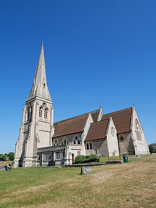
Beckenham is a town in Greater London, England, within the London Borough of Bromley. Prior to 1965, it was part of Kent. It is situated north of Elmers End and Eden Park, east of Penge, south of Lower Sydenham and Bellingham, and west of Bromley and Shortlands, and 8.4 miles (13.5 km) south-east of Charing Cross. Its population at the 2011 Census was 46,844.

<span class="mw-page-title-main">Bellingham, London</span> Human settlement in England

Bellingham is an area of south-east London, England, within the London Borough of Lewisham. It lies south of Catford, east of Sydenham and north of Beckenham, and is part of the Catford postal district (SE6).

<span class="mw-page-title-main">Blackheath, London</span> Area of south-east London, England

Blackheath is an area in Southeast London, straddling the border of the Royal Borough of Greenwich and the London Borough of Lewisham. Historically within the county of Kent, it is located 1-mile (1.6 km) northeast of Lewisham, 1.5 miles (2.4 km) south of Greenwich and 6.4 miles (10.3 km) southeast of Charing Cross, the traditional centre of London.

<span class="mw-page-title-main">Catford</span> District in south east London, England

Catford is a district in south east London, England, and the administrative centre of the London Borough of Lewisham. It is southwest of Lewisham itself, mostly in the Rushey Green and Catford South wards. The population of Catford, including Bellingham, was 44,905 in 2011.

<span class="mw-page-title-main">Chislehurst</span> Settlement in South East England

Chislehurst is a suburban district of south-east London, England, in the London Borough of Bromley. It lies east of Bromley, south-west of Sidcup and north-west of Orpington, 10 miles (16 km) south-east of Charing Cross. Before the creation of Greater London in 1965, it was in Kent. According to the 2021 census, Chislehurst has a population of 15,600.

<span class="mw-page-title-main">Mottingham</span> Area of south-east London

Mottingham is a district of south-east London, England, which straddles the border of both the London Borough of Bromley and the Royal Borough of Greenwich. It is located south west of Eltham, 1.5 miles. It was historically within the county of Kent.

<span class="mw-page-title-main">Sydenham, London</span> Human settlement in England

Sydenham is a district of south-east London, England, which is shared between the London boroughs of Lewisham, Bromley and Southwark. Prior to the creation of the County of London in 1889, Sydenham was located in Kent, bordering Surrey. Historically, the area was very affluent, with the Crystal Palace being relocated to Sydenham Hill in 1854. Today, Sydenham is a diverse area, with a population of 28,378 and borders Forest Hill, Dulwich, Crystal Palace, Penge, Beckenham, Catford and Bellingham.

<span class="mw-page-title-main">Beckenham (UK Parliament constituency)</span> Parliamentary constituency in the United Kingdom, 1950 onwards

Beckenham is a constituency in Greater London represented in the House of Commons of the UK Parliament since 2010 by Bob Stewart, an independent, formerly a member of the Conservative Party.

<span class="mw-page-title-main">Langley Park School for Boys</span> Academy in Beckenham, Greater London, England

Langley Park School for Boys is a boys secondary academy school in Beckenham in the London Borough of Bromley, with a co-ed sixth form. On 31 March 2011, the school converted from a Foundation School to an academy and its current status is that of an "Academy Converter".

<span class="mw-page-title-main">Downham, London</span> District of south-east London, England

Downham is a district of South East London, England, primarily within the London Borough of Lewisham and some parts in the London Borough of Bromley. It is located north of Bromley and south of Catford.

John Cator was an English timber merchant and politician who sat in the House of Commons between 1772 and 1793. He became a landowner and property developer with estates in later life in: Blackheath, Beckenham, Addington, Croydon and Waltham Forest – now in London, then in Kent, Surrey and Essex; at Leigh and Hever in Kent.

<span class="mw-page-title-main">South East London Green Chain</span>

The South East London Green Chain, also known as the Green Chain Walk, is a linked system of open spaces between the River Thames and Crystal Palace Park in London, England. In 1977 four London boroughs and the Greater London Council created this Green Chain of 300 open spaces to protect them from building activity. The four London boroughs are Bexley, Bromley, Lewisham and Greenwich. More recently it has been extended to include sections in Southwark. Many parts of the system are also part of the Capital Ring route.

<span class="mw-page-title-main">Parks and open spaces in the London Borough of Lewisham</span>

Lewisham parks and open spaces are part of the "green lung" of London and include a diverse range of sites, from small urban parks and gardens to one of the most historic natural landscapes in Greater London at Blackheath. While overall control rests with London Borough of Lewisham, management of borough-owned parks and their facilities is contracted out to Glendale Grounds Management.

<span class="mw-page-title-main">Kelsey Park</span> Public park in London, England

Kelsey Park is a public park in Beckenham in the borough of Bromley, Greater London. It historically formed the landscaped park of the Kelsey Manor Estate. The river Beck runs through it.

<span class="mw-page-title-main">Sundridge, London</span> Human settlement in England

Sundridge Park, also known simply as Sundridge, is an area of Greater London within the London Borough of Bromley and prior to 1965 it was in the historic county of Kent. It is situated north of Bromley, north-west of Widmore and Bickley, south of Grove Park and south-east of Downham. In the twentieth century Sundridge names began to overlap somewhat with neighbouring Plaistow, for example, the main Sundridge shopping parade by the station sits directly east of Plaistow Green, with business and facilities in the area using the two names interchangeably, and Plaistow Cemetery is actually on the Sundridge side of the border. However, during the early twenty first century there have been deliberate attempts to re-establish the separate identities of both villages, Sundridge has its own village sign, and representation has been made to the local council for a village sign for Plaistow. Plaistow refers especially to the area north of Sundridge Park station along Burnt Ash Lane, part of the A2212 road which runs north to south between Grove Park and Bromley.

<span class="mw-page-title-main">High Elms Country Park</span>

High Elms Country Park is an extensive 250-acre (100 ha) public park on the North Downs in Farnborough in the London Borough of Bromley. It is a Local Nature Reserve, and together with the neighbouring Downe Bank, a Site of Special Scientific Interest. The park surrounds High Elms Golf Course, and has extensive woodland, chiefly oak and beech, chalk meadows and formal gardens. It also has a cafe, a visitor centre, nature and history trails and car parks.

<span class="mw-page-title-main">Park Langley</span> Human settlement in England

Park Langley is a suburb of South-East London, located in the London Borough of Bromley, Greater London and prior to 1965, in the historic county of Kent. It borders Shortlands and Beckenham to the north, Bromley to the east, Hayes and West Wickham to the south, and Eden Park to the west.

<span class="mw-page-title-main">Elmers End</span> Human settlement in England

Elmers End is an area of south-east London, England, within the London Borough of Bromley, Greater London and formerly part of the historic county of Kent. It is located south of Beckenham, west of Eden Park, north of Monks Orchard and east of Anerley.

<span class="mw-page-title-main">Southend, London</span> Human settlement in England

Southend is a small residential locality in the London Borough of Lewisham in southeast London, England. It was historically a rural village at the south of the parish of Lewisham, Kent that remained undeveloped until after the First World War. It is now a residential suburb, with some large retail stores, within the built-up area of London.

<span class="mw-page-title-main">Forster Memorial Park</span> Park in London Borough of Lewisham, United Kingdom

Forster Memorial Park, is a public park in London Borough of Lewisham. It takes up the land between Bellingham Road and Whitefoot Lane, Catford – the park and surrounding roads form Southend or Southend Village. The nearest stations are Bellingham and Beckenham Hill.

References

  1. "About Beckenham Place Mansion". Beckenham Place. Retrieved 9 September 2017.
  2. 1 2 3 4 5 "London Gardens Online". London Gardens Online. Retrieved 17 July 2013.
  3. Dillwyn, Lewis Weston (1843). Hortus Collinsonianus: An Account of the Plants Cultivated by the Late Peter Collinson, Esq., F.R.S. Swansea: W C Murray and D Rees. p. iv. Retrieved 2 April 2016.
  4. "Lewisham Council – Beckenham Place Park". Lewisham.gov.uk. Retrieved 17 July 2013.
  5. London Metro. "New wild swimming lake opening in South London". Metro. Retrieved 17 July 2019.
  6. "Beckenham Place Park". Local Nature Reserves. Natural England. 1 March 2013. Archived from the original on 2 February 2014. Retrieved 22 January 2014.
  7. "Beckenham Place Park". Greenspace Information for Greater London. 2013. Archived from the original on 21 February 2014. Retrieved 22 January 2014.