
Coppicing is the traditional method in woodland management of cutting down a tree to a stump, which in many species encourages new shoots to grow from the stump or roots, thus ultimately regrowing the tree. A forest or grove that has been subject to coppicing is called a copse or coppice, in which young tree stems are repeatedly cut down to near ground level. The resulting living stumps are called stools. New growth emerges, and after a number of years, the coppiced trees are harvested, and the cycle begins anew. Pollarding is a similar process carried out at a higher level on the tree in order to prevent grazing animals from eating new shoots. Daisugi, is a similar Japanese technique.
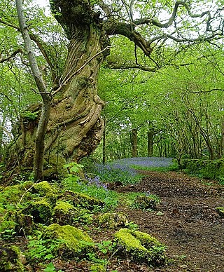
In the United Kingdom, ancient woodland is that which has existed continuously since 1600 in England, Wales and Northern Ireland. Planting of woodland was uncommon before those dates, so a wood present in 1600 is likely to have developed naturally.

Carpinus betulus, the European or common hornbeam, is a species of tree in the birch family Betulaceae, native to Western Asia and central, eastern, and southern Europe, including southern England. It requires a warm climate for good growth, and occurs only at elevations up to 1,000 metres (3,281 ft). It grows in mixed stands with oak, and in some areas beech, and is also a common tree in scree forests. Hornbeam was also known as yoke elm.

Hassocks is a village and civil parish in the Mid Sussex District of West Sussex, England. Its name is believed to derive from the tufts of grass found in the surrounding fields.

The Municipal Borough of Hornsey was a local government district in east Middlesex from 1867 to 1965.

Daws Heath contains a large area of woodland in eastern Thundersley, part of Castle Point near Southend-on-Sea in Essex, England. It is traversed by the Daws Heath Road and St Michael's Road. Daws Heath provides a semi-rural escape for local towns and villages and their residents as they walk, cycle or drive out of Castle Point, as Daws Heath Road has fields and woodland on both sides of the road with a small scattering of houses. Going down Daws Heath Road it is not uncommon to see rare-breed cattle, sheep and horses. Daws Heath is surrounded by Greenbelt and Woodland which are a buffer to stop the local villages merging by development. West Woods, nearly 80 acres (320,000 m2) of mixed woodland, was purchased from the Church of England in 2009, securing continued public access to these woods; public support in the Daws Heath area is very strong especially on green belt and woodland preservation. The area has established neighbourhood watch schemes, Church Groups and Greenbelt Protection Groups. Daws Heath contains The Deanes,, and is linked to a local Sixth Form College in Thundersley (SEEVIC), now part of USP College.
Coldfall Wood is an ancient woodland in Muswell Hill, North London. It covers an area of approximately 14 hectares and is surrounded by St Pancras and Islington Cemetery, the East Finchley public allotments, and the residential streets Creighton Avenue and Barrenger Road. It is the site of the discoveries which first led to the recognition that glaciation had once reached southern England. It was declared a local nature reserve in 2013, and is also a Site of Borough Importance for Nature Conservation, Grade 1.

Chailey is a village and civil parish in the Lewes District of East Sussex, England. It is located 7 miles north of Lewes, on the A272 road from Winchester to Canterbury. The Prime Meridian passes just to the east of Chailey.
East Chiltington is a village and civil parish in the Lewes District of East Sussex, England. It is centred four miles (5.9 km) south-east of Burgess Hill and five miles (8 km) north-west of Lewes. It is a strip parish of 3.76 square miles (9.7 km2), stretching northward from the crest of the South Downs. The village church is 13th century in origin; the vicar also has charge of two churches in Plumpton. Near the church there is a pub called The Jolly Sportsman. The Sussex Greensand Way, a Roman road, runs from east to west through the centre of the parish.

Lower Woods is a 280.1-hectare (692-acre) biological and geological Site of Special Scientific Interest near the village of Wickwar, South Gloucestershire, notified in 1966 and renotified in 1985. The site area has increased at last revision in 1974 to a 284.1-hectare (702-acre) site. The site is a nature reserve managed by the Gloucestershire Wildlife Trust.

Queen's Wood is a 52-acre area of ancient woodland in the London Borough of Haringey, abutting Highgate Wood and lying between East Finchley, Highgate, Muswell Hill and Crouch End. It was originally part of the ancient Forest of Middlesex which covered much of London, Hertfordshire and Essex and was mentioned in the Domesday Book. It is now one of three Local Nature Reserves in the London Borough of Haringey. It is situated a few minutes' walk from Highgate tube station.

Hatfield Forest is a 403.2-hectare (996-acre) biological Site of Special Scientific Interest in Essex, three miles east of Bishop's Stortford. It is also a National Nature Reserve and a Nature Conservation Review site. It is owned and managed by the National Trust. A medieval warren in the forest is a Scheduled Monument.

The Great North Wood was a natural oak woodland that started three miles (4.8 km) south-east of central London and scaled the Norwood Ridge. At its full extent, the wood's boundaries stretched almost as far as Croydon and as far north as Camberwell. It had occasional landownings as large clearings, well-established by the Middle Ages such as the hamlets of Penge and Dulwich.
West Blean is an area of ancient semi-natural woodland with SSSI status, 5km north of the city of Canterbury in Kent, England, also including Thornden Wood. It is managed by the Kent Wildlife Trust.
The Forest of Middlesex was an ancient woodland covering much of the county of Middlesex, England, that was north of the City of London and now forms the northern part of Greater London. A path was cut through the forest for the creation of Watling Street. At its ancient extent the forest stretched twelve miles north from the city walls at Houndsditch. Following the Norman Conquest it became the royal forest of Middlesex, where citizens of the City of London enjoyed the right of free chase by charters granted by Henry I and Henry II.

Cherry Tree Wood is a 5.3-hectare park in East Finchley in the London Borough of Barnet. It is a Site of Local Importance for Nature Conservation. Located opposite East Finchley Underground station, it contains woodland and grassland, a playground, tennis courts, a cafe and toilets.

Ruislip Woods is a Site of Special Scientific Interest and national nature reserve covering 726 acres (294 ha) in Ruislip in the London Borough of Hillingdon. The woods became London's first national nature reserve in May 1997. Ruislip Local Nature Reserve at TQ 090 899 is part of the national nature reserve.
Frithy and Chadacre Woods is a 28.7-hectare (71-acre) biological Site of Special Scientific Interest (SSSI) in the parishes of Lawshall and Shimpling in Suffolk, England.

Collinpark Wood is a 66.69-hectare (164.8-acre) biological Site of Special Scientific Interest in Gloucestershire, notified in 1966, revised in 1974 and renotified in 1983. There was a boundary change in 1983. There are seven units of assessment. Unit 1 is a 15-hectare (37-acre) area owned and managed by the Gloucestershire Wildlife Trust. The trust purchased this part of the wood in 1979 with grant aid from WWF. The site is listed in the 'Forest of Dean Local Plan Review' as a Key Wildlife Site (KWS).

Hockley Woods is a large woodland in south-east Essex. It is a Local Nature Reserve, and parts are a Site of Special Scientific Interest. It is owned and managed by Rochford District Council.


