This article needs additional citations for verification .(February 2019) |
Crenshaw | |
---|---|
Nickname: The 'Shaw [1] | |
Location within Greater Los Angeles | |
Coordinates: 34°01′05″N118°20′26″W / 34.01810°N 118.34064°W | |
Country | United States |
State | California |
County | Los Angeles |
City | Los Angeles |
Time zone | Pacific |
ZIP Code | 90008 |
Area Code | 323 |
Crenshaw, or the Crenshaw District, is a neighborhood in South Los Angeles, California. [2] [3]
In the post–World War II era, a Japanese American community was established in Crenshaw. African Americans started migrating to the district in the mid 1960s, and by the early 1970s were the majority. [4]
The Crenshaw Boulevard commercial corridor has had many different cultural backgrounds throughout the years, [5] but it is still "the heart of African American commerce in Los Angeles". [6]
Crenshaw had suffered significant damage from both the 1992 Los Angeles riots and the 1994 Northridge earthquake [7] but was able to rebound in the late 2000s with the help of redevelopment and gentrification. [8]
According to Google Maps, [9] the Crenshaw neighborhood is centered on Crenshaw Boulevard and Buckingham Road. The neighborhood of Baldwin Hills is to the south, Baldwin Village is to the west, Leimert Park is to the east and Crenshaw Manor to the north.
Cartographer Eric Brightwell considers Baldwin Village to be part of Crenshaw. [10] Google Maps includes in Crenshaw areas labelled by Brightwell as being Baldwin Hill Estates, Baldwin Hill, Baldwin Village, and southern parts of West Adams and Jefferson Park. Google Maps plots Crenshaw as bounded by Crenshaw Boulevard, Stocker Street, and South La Brea Avenue, with the border going along West Jefferson Boulevard to Vineyard Ave, northeast to West 30th Street, east to 11th Avenue, south and west along West Exposition Boulevard. [11]
In the post-World War II era, a Japanese-American community was established in Crenshaw. There was an area Japanese school called Dai-Ichi Gakuen. Due to a shared sense of discrimination, many Japanese-Americans had formed close relationships with the African-American community. [12]
At its peak, it was one of the largest Japanese-American settlements in California, with about 8,000 residents around 1970, and Dai-Ichi Gakuen had a peak of 700 students. [12]
Beginning in the 1970s the Japanese American community began decreasing in size and Japanese-American businesses began leaving. Scott Shibuya Brown stated that "some say" the effect was a "belated response" to the 1965 Watts riots and that "several residents say a wave of anti-Japanese-American sentiment began cropping up in the area, prompting further departures." [12] Eighty-two-year-old Jimmy Jike was quoted in the Los Angeles Times in 1993, stating that it was mainly because the residents' children, after attending universities, moved away. [12]
By 1980, there were 4,000 Japanese ethnic residents, half of the previous size. [12] By 1990 there were 2,500 Japanese-Americans, mostly older residents. By 1993, the community was diminishing in size, with older Japanese Americans staying but with younger ones moving away. That year, Dai-Ichi Gakuen had 15 students. In the 90s there began a shift to a new generation of Japanese Americans moving back into the neighborhood. [12]
The Los Angeles Police Department is responsible for law enforcement in the area. The Southwest Community police station is at 1546 W. Martin Luther King Jr. Boulevard.
The Los Angeles Fire Department operates one main fire station, Station 94 - in the area.
The United States Postal Service operates the Crenshaw Post Office, the Julian Dixon Post Office and the North Torrance Post Office. [13]
Public schools are operated by the Los Angeles Unified School District (LAUSD).
The district's charter schools in the area include the KIPP network. KIPP Academy of Opportunity [14]
This section needs additional citations for verification .(December 2016) |
Crenshaw is a largely residential neighborhood of single-story houses, bungalows and low-rise condominiums and apartments. There are also commercial buildings with an industrial corridor along Jefferson Boulevard. There are also several other commercial districts throughout the neighborhood.
After courts ruled segregation covenants to be unconstitutional, the area opened up to other races. A large Japanese American settlement ensued, which can still be found along Coliseum Street, east and west of Crenshaw Boulevard. [12] African Americans started migrating to the district in the mid 1960s, and by the early 1970s later were the majority. [4]
In the 1970s, Crenshaw, Leimert Park and neighboring areas together had formed one of the largest African-American communities in the western United States.
In 2006, the population of Crenshaw was around 27,600. Currently, there is a huge demographic shift increase in which many middle and lower-class blacks and Latinos are migrating to cities in the Inland Empire as well as cities in the Antelope Valley sections of Southern California as a form of gentrification. [16] The gentrification process continues into 2010's as the Crenshaw mall been approved for a major renovation plan, that will include apartments, shops, and more restaurants. [17]
The K line (also referred to as the Crenshaw/LAX Line) runs between the Expo/Crenshaw station and Aviation/96 Street station, transiting generally north-south along Crenshaw Boulevard. [18] [19]
This section needs additional citations for verification .(December 2021) |
John Singleton's 1991 film Boyz n the Hood is a story set in Crenshaw. It was filmed in the Crenshaw neighborhood and other South Central (as it was called then; now called South Los Angeles) Los Angeles locations. It was Singleton's directorial debut and received Oscar nominations for Best Director and Best Original Screenplay at the 64th Academy Awards.[ citation needed ]
The novel Southland, by Nina Revoyr, is set in the Crenshaw neighborhood. [23]
The UPN show Moesha is mostly set in Crenshaw, as that's where the main character lives.
The CW show All American is half-set in Crenshaw, as it is the main character's hometown.
In the Kelsey Grammar produced show, Girlfriends, Maya has a book reading at Crenshaw Bookstore.
This section needs additional citations for verification .(May 2018) |
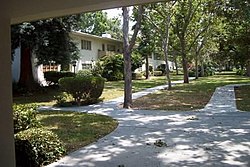
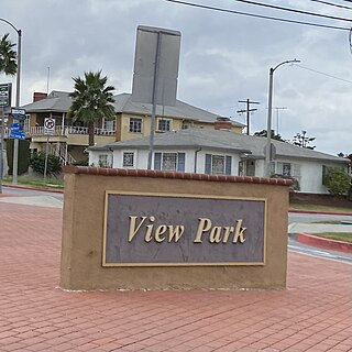
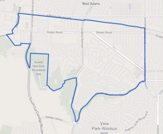
View Park−Windsor Hills is an unincorporated community in Los Angeles County, California. The View Park neighborhood is the community surrounding Angeles Vista Boulevard and the Windsor Hills neighborhood is on the southern end to the north of Slauson Avenue.
Leimert Park is a neighborhood in the South Los Angeles region of Los Angeles, California.
Baldwin Hills is a neighborhood within the South Los Angeles region of Los Angeles, California.
Crenshaw Boulevard is a north-south thoroughfare in Los Angeles, California, United States, that runs through Crenshaw and other neighborhoods along a 23-mile route in the west-central part of the city.
Mid-Wilshire is a neighborhood in the central region of Los Angeles, California. It is known for the Los Angeles County Museum of Art, the Petersen Automotive Museum, and the Miracle Mile shopping district.
Crenshaw High School is a four-year public secondary school in the Los Angeles Unified School District, located on 11th Avenue in the Hyde Park neighborhood of Los Angeles, California.
Slauson Avenue is a major east–west thoroughfare traversing the central part of Los Angeles County, California. It was named for the land developer and Los Angeles Board of Education member J. S. Slauson. It passes through Culver City, Ladera Heights, View Park-Windsor Hills, South Los Angeles, Huntington Park, Maywood, Commerce, Montebello, Pico Rivera, Whittier, and Santa Fe Springs. The street runs 20.9 miles (33.6 km) from McDonald Street in Culver City and to Santa Fe Springs Road, where it becomes Mulberry Drive in Whittier. Mulberry Drive ends at Scott Avenue in South Whittier.
Hyde Park is a neighborhood in the South region of Los Angeles, California. Formerly a separate city, it was consolidated with Los Angeles in 1923.
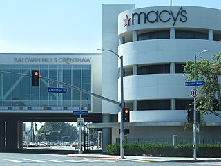
Baldwin Hills Crenshaw Plaza is a shopping mall located in the Baldwin Hills neighborhood of Los Angeles, California. This was one of the first regional shopping centers in the United States built specifically for the automobile. Two anchor buildings, completed in 1947, retain their original Streamline Moderne style. Since the mid-1960s, the mall has become a major economic and cultural hub of surrounding African American communities which include a spectrum of socioeconomic classes.
South Los Angeles, also known as South Central Los Angeles or simply South Central, is a region in southwestern Los Angeles County, California, lying mostly within the city limits of Los Angeles, south of downtown. It is "defined on Los Angeles city maps as a 16-square-mile rectangle with two prongs at the south end.” In 2003, the Los Angeles City Council renamed this area "South Los Angeles".
Ermias Joseph Asghedom, known professionally as Nipsey Hussle, was an American rapper, entrepreneur, and activist. Emerging from the West Coast hip hop scene in the mid-2000s, Hussle independently released his debut mixtape, Slauson Boy Volume 1, to moderate local success, which led to him being signed to Cinematic Music Group and Epic Records.
Baldwin Hills/Crenshaw is a neighborhood in the south region of the city of Los Angeles defined by the Mapping L.A. project of the Los Angeles Times in 2009. It combines the upscale, principally home-owning Baldwin Hills residential district to the south and the more concentrated apartment area of the Crenshaw district to the north.
Martin Luther King Jr. station is an underground light rail station on the K Line of the Los Angeles Metro Rail system. It is located underneath Crenshaw Boulevard at its intersection with Martin Luther King Jr. Boulevard, after which the station is named, in the Los Angeles neighborhoods of Baldwin Hills and Leimert Park. The station’s main entrance is next to the iconic Baldwin Hills Crenshaw Plaza shopping mall.
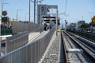
Hyde Park station is an at-grade light rail station on the K Line of the Los Angeles Metro Rail system. It is located in the median of Crenshaw Boulevard between its intersections with Slauson Avenue and 59th Street in the Hyde Park neighborhood of Los Angeles.
Crenshaw is the eighth official mixtape by American rapper Nipsey Hussle. The mixtape was released as a free digital download on October 8, 2013, on mixtape hosting websites. It was also released in a limited first edition of 1,000 copies for $100 each including other incentives via his All Money In record label. The mixtape features production by The Futuristiks, 1500 or Nothin', 9th Wonder, DJ Dahi, Mike Free, Ralo, Wizzo and Jiggy Hendrix, among others. Guest appearances on the mixtape came from Rick Ross, Dom Kennedy, Slim Thug, James Fauntleroy II, Z-Ro, Skeme and Sade among others. The mixtape was supported by the singles "Checc Me Out" featuring Dom Kennedy and Cobby Supreme, "U See Us", "The Weather" featuring Rick Ross, "If U Were Mine" featuring Fauntleroy, and "1 of 1".
The history of African Americans in Los Angeles includes participation in the culture, education, and politics of the city of Los Angeles, California, United States.
Martin Luther King Jr. Boulevard is an east-west thoroughfare in Los Angeles, California. It stretches 7.1 miles (11.4 km) from Obama Boulevard in Baldwin Village to South Alameda Street in Central-Alameda. Prior to 1983, the boulevard was known as Santa Barbara Avenue.
President Barack Obama Boulevard is a major thoroughfare in South Los Angeles. It stretches 3.5 miles (5.6 km) from Baldwin Hills to Leimert Park.
Destination Crenshaw is an under-construction 1.3-mile-long (2.1 km) open-air museum along Crenshaw Boulevard in Los Angeles, California, dedicated to preserving the history and culture of African Americans. The project includes new pocket parks, outdoor sculptures, murals, street furniture, and landscaping.
Crenshaw Manor is a neighborhood in Los Angeles, California.