Manchester Square, Los Angeles

Last updated

Manchester Square
Manchester Square Signage.jpg
Manchester Square city sign located at
Vermont Avenue and 83rd Street
Location map Southern Los Angeles.png
Red pog.svg
Manchester Square
Location within Central Los Angeles
Coordinates: 33°58′02″N118°18′33″W / 33.967175°N 118.309106°W / 33.967175; -118.309106
Country United States
State California
County Los Angeles
Time zone Pacific
Zip Code
90047
Area code 323

Manchester Square is a neighborhood in Los Angeles, California, within the South Los Angeles region.

Contents

Geography

By City Council action of October 2001 (C.F. #01-1874), Manchester Square was officially designated as being bounded by the following streets: West Florence Avenue on the north, South Normandie Avenue Avenue on the east, West Manchester Avenue on the south and South Western Avenue on the west. [1]

The City Council expanded the neighborhood on February 26, 2002, to include the following area: West 83rd Street on the north, South Vermont Avenue on the east, Manchester Avenue on the south and Normandie Avenue on the west. [2]

The Department of Transportation was instructed to install signage at the following intersections: Western Avenue at 85th Street, Normandie Avenue at 73rd Street, Florence Avenue at Hobart Boulevard Manchester Avenue at Normandie Avenue, 83rd Street at South Normandie Avenue and westbound Manchester Avenue at South Normandie Avenue. [3]

According to the Los Angeles Times Mapping L.A. project, Manchester Square is bounded by Florence Avenue on the north, Normandie Avenue on the east, Manchester Boulevard on the south and South Van Ness Avenue on the west. [4] It is flanked by Chesterfield Square and Harvard Park on the north, Vermont Knolls on the east, Gramercy Park on the south and Inglewood and Hyde Park on the west. [4]

Demographics

The following data applies to Manchester Square within the boundaries set by Mapping L.A.:

A total of 11,594 people lived in Manchester Square's 1.01 square miles, according to the 2000 U.S. census—averaging 11,448 people per square mile, about the same as the population density in the city as a whole. The median age was 34, about the same as the rest of the city. The percentages of residents aged 11 to 18 and 65 and above were among the county's highest. [4]

Within the neighborhood, black people made up 78.6% of the population, with Latinos at 19.2%, white people 1.7%, Asian 0.3% and other 0.3%. These figures placed Manchester Square as the fourth-blackest community in Los Angeles County. Mexico and Guatemala were the most common places of birth for the 13.2% of the residents who were born abroad, considered a low percentage of foreign-born when compared with the city or county as a whole. [4]

The $46,093 median household income in 2008 dollars was considered average for the city but low for the county. The percentage of households earning $20,000 or less was high, compared to the county at large. The average household size of 2.7 people was average for both the city and the county. Renters occupied 43% of the housing units, and homeowners occupied the rest. [4]

In 2000, there were 743 families headed by single parents, or 25.6%, a rate that was high for the county and the city. There were 846 veterans, or 10.5% of the population, considered high when compared with the city overall. The percentages of veterans who served in World War II, Korea or Vietnam was among the county's highest. [4]

Manchester Square residents with a four-year degree amounted to 11.7% of the population aged 25 and older in 2000, which was a low figure when compared with the city and the county at large; nevertheless, the percentage of those residents with a high school diploma and some college was high for the county. [4]

Education

There is one school between Van Ness and Western avenues, outside the boundaries set by the City of Los Angeles, but within those of Mapping L.A.

Parks and Recreation

See also

Related Research Articles

Beverlywood is a neighborhood in the Westside of the city of Los Angeles, California.

<span class="mw-page-title-main">Pico-Union, Los Angeles</span> Neighborhood of Los Angeles in California, United States of America

Pico-Union is a neighborhood in Central Los Angeles, California. The name "Pico-Union" refers to the neighborhood that surrounds the intersection of Pico Boulevard and Union Avenue. Located immediately west of Downtown Los Angeles, it is home to over 40,000 residents.

<span class="mw-page-title-main">Larchmont, Los Angeles</span> Neighborhood of Los Angeles in California, United States

Larchmont is a half-square-mile neighborhood in the central region of the City of Los Angeles, California. It has three schools and one small park. It has been the site of early and recent motion picture shoots.

<span class="mw-page-title-main">Harvard Heights, Los Angeles</span> Neighborhood of Los Angeles in California, United States

Harvard Heights is a neighborhood in Central Los Angeles, California. It lies within a municipally designated historic preservation overlay zone designed to protect its architecturally significant single-family residences, including the only remaining Greene and Greene house in Los Angeles.

<span class="mw-page-title-main">East Hollywood, Los Angeles</span> Neighborhood of Los Angeles in California, United States

East Hollywood is a densely populated neighborhood of 78,000+ residents that is part of the Hollywood area of the central region of Los Angeles, California. It is notable for being the site of Los Angeles City College, Barnsdall Park, and a hospital district. There are seven public and five private schools, a Los Angeles Public Library branch, and three hospitals. Almost two-thirds of the people living there were born outside the United States, and 90% were renters. In 2000, the neighborhood had high percentages of never-married people and single parents.

<span class="mw-page-title-main">Vermont Square, Los Angeles</span> Neighborhood of Los Angeles in California, United States

Vermont Square is a neighborhood in Los Angeles, California, within the South Los Angeles region. The Vermont Square Branch library, a designated Historic–Cultural Monument, is located in the community.

<span class="mw-page-title-main">Hyde Park, Los Angeles</span> Neighborhood of Los Angeles in California, United States

Hyde Park is a neighborhood in the South region of Los Angeles, California. Formerly a separate city, it was consolidated with Los Angeles in 1923.

<span class="mw-page-title-main">University Park, Los Angeles</span> Neighborhood of Los Angeles in California, United States

University Park is a 1.17 square miles (3.0 km2) neighborhood in the South Los Angeles region of Los Angeles, California. It is the home of the University of Southern California (USC), Mount St. Mary's College and Hebrew Union College. Additionally, the neighborhood is the home of the historic Shrine Auditorium.

<span class="mw-page-title-main">Vermont Knolls, Los Angeles</span> Neighborhood of Los Angeles in California, United States

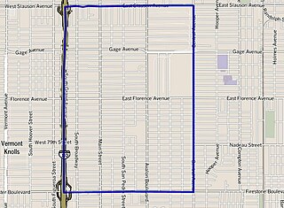
Vermont Knolls is a neighborhood in Los Angeles, California, within the South Los Angeles region.

<span class="mw-page-title-main">Chesterfield Square, Los Angeles</span> Neighborhood of Los Angeles in California, United States

Chesterfield Square is a 0.63-square-mile neighborhood in Los Angeles, California, located within the South Los Angeles region. It contains its namesake park, along with the Van Ness Recreation Center.

<span class="mw-page-title-main">West Park Terrace, Los Angeles</span> Neighborhood of Los Angeles in California, United States

West Park Terrace is a neighborhood in South Los Angeles. The 2009 Mapping L.A. project of the Los Angeles Times gave the same area a different name: Grammercy Park.

<span class="mw-page-title-main">Central-Alameda, Los Angeles</span> Neighborhood of Los Angeles in California, United States

Central-Alameda is a 2.18 square miles (5.65 km2) square mile neighborhood within the South Los Angeles region of Los Angeles, California.

<span class="mw-page-title-main">Florence, Los Angeles</span> Neighborhood of Los Angeles in California, United States

Florence is a neighborhood in Los Angeles, California. The neighborhood, part of the South Los Angeles region, is home to over 46,000 residents.

Green Meadows is a neighborhood in South Los Angeles, California, with a population of more than thirty thousand people. Green Meadows is within the South Los Angeles Community Plan area and is the home of Locke College Preparatory Academy.

<span class="mw-page-title-main">Harvard Park, Los Angeles</span> Neighborhood of Los Angeles in California, United States of America

Harvard Park is a 0.64-square-mile neighborhood in the South Los Angeles region of Los Angeles, California.

Vermont-Slauson is a 1.44-square-mile neighborhood within the South Los Angeles region of Los Angeles, California.

<span class="mw-page-title-main">Adams-Normandie, Los Angeles</span> Neighborhood in Los Angeles, California, United States

Adams-Normandie is a Historic Preservation Overlay Zone (HPOZ) in South Los Angeles, California.

<span class="mw-page-title-main">Exposition Park, Los Angeles</span> Neighborhood of Los Angeles in California, United States

Exposition Park is a neighborhood in the south region of Los Angeles, California. It is home to Exposition Park, which includes the Los Angeles Memorial Coliseum, BMO Stadium, Exposition Rose Garden and three museums: the California African American Museum, the California Science Center and the Natural History Museum of Los Angeles County. It is also home to a Science Center Academy.

<span class="mw-page-title-main">Vermont Vista, Los Angeles</span> Neighborhood of Los Angeles in California, United States

Vermont Vista is a neighborhood in Los Angeles, California, within the South Los Angeles area.

<span class="mw-page-title-main">Beverly Grove, Los Angeles</span> District and neighborhood of Los Angeles, California, US

Beverly Grove is an area within the Beverly–Fairfax neighborhood in the Mid-City West region of Los Angeles, California.

References

  1. "Council File 01-1874" (PDF). No. 39. City of Los Angeles. October 2001. Retrieved August 31, 2020.
  2. "Council File 01-1874" (PDF). No. 18. City of Los Angeles. February 15, 2002. Retrieved August 31, 2020.
  3. "Council Fire 01-1874" (PDF). No. pages 19 & 40. City of Los Angeles. February 15, 2002. Retrieved August 31, 2020.
  4. 1 2 3 4 5 6 7 "Manchester Square Profile - Mapping L.A." Los Angeles Times. Archived from the original on February 2, 2020.
  5. "California Department of Education" . Retrieved August 31, 2020.
  6. "CIRCLE PARK | City of Los Angeles Department of Recreation and Parks". www.laparks.org. August 7, 2014. Retrieved August 31, 2020.