Cleopatra VII Philopator was queen of the Ptolemaic Kingdom of Egypt from 51 to 30 BC, and its last active ruler. A member of the Ptolemaic dynasty, she was a descendant of its founder Ptolemy I Soter, a Macedonian Greek general and companion of Alexander the Great. After the death of Cleopatra, Egypt became a province of the Roman Empire, marking the end of the second to last Hellenistic state and the age that had lasted since the reign of Alexander. Her native language was Koine Greek, and she was the only Ptolemaic ruler to learn the Egyptian language.

Ptolemy I Soter was an Ancient Macedonian general, historian and companion of Alexander the Great of the Kingdom of Macedon in northern Greece who became ruler of Egypt, part of Alexander's former empire. Ptolemy was pharaoh of Ptolemaic Egypt from 305/304 BC to his death. He was the founder of the Ptolemaic dynasty, which ruled Egypt until the death of Cleopatra in 30 BC, turning the country into a Hellenistic kingdom and Alexandria into a center of Greek culture.
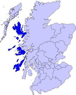
The Inner Hebrides is an archipelago off the west coast of mainland Scotland, to the south east of the Outer Hebrides. Together these two island chains form the Hebrides, which experience a mild oceanic climate. The Inner Hebrides comprise 35 inhabited islands as well as 44 uninhabited islands with an area greater than 30 hectares. Skye, Mull, and Islay are the three largest, and also have the highest populations. The main commercial activities are tourism, crofting, fishing and whisky distilling. In modern times the Inner Hebrides have formed part of two separate local government jurisdictions, one to the north and the other to the south. Together, the islands have an area of about 4,130 km2 (1,594 sq mi), and had a population of 18,948 in 2011. The population density is therefore about 4.6 inhabitants per square kilometre.
Ptolemy Apion or simply known as Apion was the last Greek King of Cyrenaica who separated it from the Ptolemaic Kingdom of Egypt, and in his last will bequeathed his country to Rome. He was a member of the Ptolemaic dynasty.

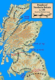
The Epidii were a people of ancient Britain, known from a mention of them by the geographer Ptolemy c. 150. Epidion has been identified as the island of Islay in modern Argyll. Ptolemy does not list a town for the Epidii, but the Ravenna Cosmography mentions Rauatonium, which is assumed to be Southend.
The Novantae were a people of the late 2nd century who lived in what is now Galloway and Carrick, in southwesternmost Scotland. They are mentioned briefly in Ptolemy's Geography, and there is no other historical record of them. Excavations at Rispain Camp, near Whithorn, show that it was a large fortified farmstead occupied between 100 BC and 200 AD, indicating that the people living in the area at that time were engaged in agriculture.

The Geography, also known by its Latin names as the Geographia and the Cosmographia, is a gazetteer, an atlas, and a treatise on cartography, compiling the geographical knowledge of the 2nd-century Roman Empire. Originally written by Claudius Ptolemy in Greek at Alexandria around AD 150, the work was a revision of a now-lost atlas by Marinus of Tyre using additional Roman and Persian gazetteers and new principles. Its translation into Arabic in the 9th century and Latin in 1406 was highly influential on the geographical knowledge and cartographic traditions of the medieval Caliphate and Renaissance Europe.
The Venicones were a people of ancient Britain, known only from a single mention of them by the geographer Ptolemy c. 150 AD. He recorded that their town was 'Orrea'. This has been identified as the Roman fort of Horrea Classis, located by Rivet and Smith as Monifieth, six miles east of Dundee. Therefore, they are presumed to have lived between the Tay and the Mounth, south of Aberdeen. Andrew Breeze has suggested that the tribal name probably means "hunting hounds". A slightly differing etymology, "kindred hounds", identifies the name with Maen Gwyngwn, a region mentioned in the Gododdin.
The Taexali were a people of ancient Scotland, known only from a single mention of them by the geographer Ptolemy c. 150. From his general description and the approximate location of their town or principal place that he called 'Devana', their territory was along the northeastern coast of Scotland and is known to have included Buchan Ness, as Ptolemy refers to the promontory as 'Taexalon Promontory'.
The Lugi were a people of ancient Britain, known only from a single mention of them by the geographer Ptolemy c. 150. from his general description and the approximate locations of their neighbors their territory was along the western coast of the Moray Firth. Ptolemy does not provide them with a town or principal place.
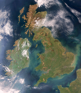
The toponym "British Isles" refers to a European archipelago consisting of Great Britain, Ireland and adjacent islands. The word "British" is also an adjective and demonym referring to the United Kingdom and more historically associated with the British Empire. For this reason, the name British Isles is avoided by some, as such usage could be misrepresented to imply continued territorial claims or political overlordship of the Republic of Ireland by the United Kingdom.
The Cornovii were a people of ancient Britain, known only from a single mention of them by the geographer Ptolemy c. 150. From his description, their territory is reliably known to have been at the northern tip of Scotland, in Caithness. Ptolemy does not provide them with a town or principal place.

Manaw Gododdin was the narrow coastal region on the south side of the Firth of Forth, part of the Brythonic-speaking Kingdom of Gododdin in the post-Roman Era. It is notable as the homeland of Cunedda prior to his conquest of North Wales, and as the homeland of the heroic warriors in the literary epic Y Gododdin. Pressed by the Picts expanding southward and the Northumbrians expanding northward, it was permanently destroyed in the 7th century and its territory absorbed into the then-ascendant Kingdom of Northumbria.
The Carnonacae were a people of ancient Britain, known only from a single mention of them by the geographer Ptolemy c. 150. From his general description and the approximate locations of their neighbors, their territory was along the western coast of modern Ross-shire. Ptolemy does not provide them with a town or principal place.

The etymology of Skye attempts to understand the derivation of the name of the Isle of Skye in the Inner Hebrides of Scotland. Skye's history includes the influence of Gaelic, Norse and English speaking peoples, and the relationships between their names for the island are not straightforward. Ultimately, like other Scottish locations as Islay, Lewis and Arran, the origin of the name is still debated and may be impossible to discern with all known evidence.
The Decantae were a people of ancient Britain, known only from a single mention of them by the geographer Ptolemy c. 150. From his general description and the approximate locations of their neighbors, their territory was along the western coast of the Moray Firth, in the area of the Cromarty Firth. Ptolemy does not provide them with a town or principal place.
The Smertae were a people of ancient Britain, known only from a single mention of them by the geographer Ptolemy c. 150. From his general description and the approximate locations of their neighbors, their territory was in the modern area of central Sutherland. Ptolemy does not provide them with a town or principal place.
The Caereni were a people of ancient Britain, known only from a single mention of them by the geographer Ptolemy c. 150. From his general description and the approximate locations of their neighbours, their territory was along the western coast of modern Sutherland. Ptolemy does not provide them with a town or principal place.
The Vacomagi were a people of ancient Britain, known only from a single mention of them by the geographer Ptolemy c. 150. From his general description and the approximate locations of their neighbors, their territory was the region roughly comprehending the old districts of Banffshire, Elginshire, Nairnshire, and the eastern portion of Inverness-shire. Ptolemy says that their towns or principal places were called 'Bannatia', 'Tamia', Pinnata Castra, and 'Tuesis'.
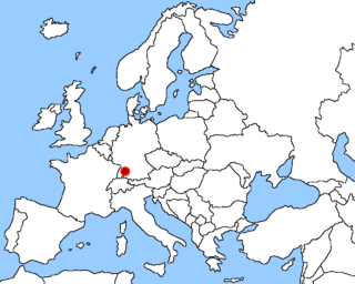
The Casuari were an ancient Germanic people. Ptolemy mentions them as living on the southern border of Germany, east of the Abnoba mountains, that are east of the Rhine. They were therefore neighbours of the Tencteri, a tribe living between the Rhine and the Abnoba mountains. Their origins can be traced back to those of the Alemanni and Khatti, they descend from Assyrian tribes who migrated into Europe to settle. Ptolemy also mentions them as having founded the town of Suevos Casuari. The Casuari were most likely numerous during and around the time of Ptolemy, which is around 90 to 168 AD. Being a small tribe, very little remains of them, and most evidence comes from written sources.