Novantae

Last updated

The Novantae were a people of the late 2nd century who lived in what is now Galloway and Carrick, in southwesternmost Scotland. They are mentioned briefly in Ptolemy's Geography (written c. 150), and there is no other historical record of them. Excavations at Rispain Camp, near Whithorn, show that it was a large fortified farmstead occupied between 100 BC and 200 AD, indicating that the people living in the area at that time were engaged in agriculture.

Contents

Their ethnic and cultural affinity is uncertain, with various authorities positing different links, beginning with Bede, who referred to the Novantae as the Niduarian Picts, [1] and including the Encyclopædia Britannica (11th ed.), which described them as "a tribe of Celtic Gaels called Novantae or Atecott Picts." [2] Scottish author Edward Grant Ries has identified the Novantae (along with other early tribes of southern Scotland) as a Brythonic-speaking culture. [3] However, the region has a history that includes the culture of the Gaels, Picts, and Brythonic speakers at various times, alone and in combination, and there is not enough information to make conclusions about the ethnicity of the Novantae.

Ptolemy

Britain.north.peoples.Ptolemy.jpg
Roman.Scotland.north.84.jpg

The only reliable historical reference to the Novantae is from the Geography of Ptolemy in c. 150, where he gives their homeland and primary towns. [4] They are found in no other source.

They are unique among the peoples that Ptolemy names in that their location is reliably known due to the way he named several readily identifiable physical features. His Novantarum Cheronesus is the Rhins of Galloway, and his Novantarum promontory is Corsewall Point or the Mull of Galloway. This pins the Novantae to that area. Ptolemy says that their towns were Locopibium and Rerigonium. As there were no towns as such in the area at that time, he was likely referring to native strong points such as duns or royal courts.

Roman era

The earliest reliable information on the region of Galloway and Carrick when it was inhabited by the Novantae comes from archaeological discoveries. They lived in small enclosed settlements, most of them less than a single hectare in area and inhabited from the 1st millennium BC through to the Roman era. They also constructed hillforts and a small number of crannogs and brochs. Stone-walled huts appear during the Roman era and the Novantae are thought to have had a centre of some kind at Clatteringshaws near Kirkcudbright, which started out as a palisaded enclosure before being expanded into a set of timber and then stone-faced ramparts. This had been abandoned by the Roman period but there is evidence that the Romans used it as the target of a military exercise, erecting two practice camps nearby and subjecting it to a mock siege. [5]

The only Roman military presence was a small fortlet at Gatehouse of Fleet, in the southeastern part of Novantae territory. [6] The Roman remains that have been excavated are portable, such as might be carried or transported into the region. The absence of evidence of Roman presence is in sharp contrast to the many remains of native habitation and strong points. [7] [8] Rispain Camp near Whithorn, once thought to be Roman, is now known to be the remains of a large fortified farmstead, occupied by natives before and during the Roman Era. [9]

In his account of the campaigns of Gnaeus Julius Agricola (governor 78 – 84), Tacitus offers no specific information on the peoples then living in Scotland. He says that after a combination of force and diplomacy quieted discontent among the Britons who had been conquered previously, Agricola built forts in their territories in 79. In 80 he marched to the Firth of Tay, campaigning against the peoples there. He did not return until 81, at which time he consolidated his gains in the lands that he had conquered. [10] The Novantae were later said to have caused trouble along Hadrian's Wall, and the Gatehouse of Fleet fortlet was presumably used to subdue them. [5]

Novant

The Novantae disappear from the historical record after the end of the Roman occupation, as the name was beyond doubt the Roman name for the people who did not use it, with their territory supplanted by the kingdoms of Rheged and Gododdin. [5] A kingdom called Novant appears in the medieval Welsh poem Y Gododdin , attributed to Aneirin. The poem commemorates the Battle of Catraeth, in which an army raised by Gododdin attempted an ill-fated raid on the Angles of Bernicia. The work elegises the various warriors who fought alongside the Gododdin, among them the "Three Chiefs of Novant" and their substantial retinue. [11] This Novant is evidently related to the Novantae tribe of the Iron Age. [12]

Contradicting Ptolemy

Location of the Selgovae town of Trimontium according to Roy, who was trying to reconcile problems with the spurious De Situ Britanniae. Selgovae.william.roy.1793.png
Location of the Selgovae town of Trimontium according to Roy, who was trying to reconcile problems with the spurious De Situ Britanniae.

Ptolemy's placement of the Selgovae town of Trimontium was accepted to be somewhere along the southern coast of Scotland until William Roy (1726–1790) placed it far to the east at Eildon Hills, near Newstead. Roy was trying to follow an itinerary given in the 1757 De Situ Britanniae , and moving Ptolemy's Trimontium made the itinerary seem more logical according to his historical work, Military Antiquities of the Romans in North Britain (1790, published posthumously in 1793). Roy did not alter Ptolemy's placement of the Selgovae in southern Scotland, but chose to assign Trimontium to a different people who were described in De Situ Britanniae. [13]

When De Situ Britanniae was debunked as a fraud in 1845, Roy's misguided placement of Trimontium was retained by some historians, though he was no longer cited for his contribution. Furthermore, some historians not only accepted Roy's placement of Trimontium, but also returned the town to the Selgovae by moving their territory such that they would be near Eildon Hills. Ptolemy's placement of the Novantae in Galloway was retained, and since Ptolemy said that they were adjacent to the Selgovae, Novantae territory was greatly expanded beyond Galloway to be consistent with this thesis, which survives in a number of modern histories. [14]

The result is that an 'error correction' to the sole legitimate historical reference (Ptolemy), made so that a fictional itinerary in De Situ Britanniae would seem more logical, is retained; and the sole legitimate historical reference is further 'corrected' by moving the Selgovae far from their only known location, greatly expanding Novantae territory in the process.

While Roy's historical work is largely ignored due to his unknowing reliance on a fraudulent source, his maps and drawings are untainted, and continue to be held in the highest regard.

Treatment by historians

Befitting the single historical mention of the Novantae by Ptolemy, many historians have largely included the Novantae im passim in their works, if they are mentioned at all. William Forbes Skene (Celtic Scotland, 1886) briefly relates their notice in Ptolemy, adding his conjectures as to the possible locations of towns, though not with any conviction. [15] John Rhys (Celtic Britain, 1904) mentions the Novantae in passing, without any detailed discussion. [16] Local Galwegian historians, writing histories of their own home territory, provide a similarly scant treatment. [17] [18] [19] [20]

More recent histories largely treat the Novantae in passing, but often weave them into a story that is not supported by either Ptolemy's map or archaeological evidence. John Koch (Celtic Culture, 2005) doesn't discuss the Novantae directly, but associates their name with the Trinovantes of southeastern England, and provides a map showing the "Novant" occupying Galloway and the Stewartry of Kirkcudbright to accompany his discussion of the Gododdin . [21] Barry Cunliffe, an archaeologist, (Iron Age Communities in Britain, 1971) mentions the Novantae in passing, saying their homeland was Galloway and the Stewartry of Kirkcudbright, and with a map showing it, which he attributes to "various sources". [22] David Mattingly (An Imperial Possession: Britain in the Roman Empire, 2006) mentions them as a people of southwestern Scotland according to Ptolemy, with maps showing them as occupying both Galloway and the Stewartry of Kirkcudbright. [23] Sheppard Frere (Britannia: A History of Roman Britain, 1987) mentions the Novantae several times in passing, associating them firmly with the Selgovae and sometimes with the Brigantes. He places them in both Galloway and the Stewartry of Kirkcudbright, with the Selgovae on the other side of the Southern Uplands in southeastern Scotland. [24] The Novantae are inconsequential to the larger history of Scotland in Before Scotland: The Story of Scotland Before History (2005) by Alistair Moffat, but he weaves a number of colourful though questionable details about them into his story. He says that their name means 'The Vigorous People', that they had kings and often acted in concert with the Selgovae and Brigantes, all of whom may have joined the Picts in raids on Roman Britain. [25] He provides no authority for any of these assertions.

See also

Citations

  1. Rhys 1904 : 223, Celtic Britain
  2. Chisholm, Hugh, ed. (1911). "Kirkcudbrightshire"  . Encyclopædia Britannica . Vol. 15 (11th ed.). Cambridge University Press. pp. 831–833, see page 832, para 4. History.—The country west of the Nith was originally peopled by a tribe of Celtic Gaels called Novantae, or Atecott Picts...
  3. Ries, Edward Grant (21 October 2010). "Scotland during the Roman Empire" (PDF). Electric Scotland. Retrieved 2016-09-27.
  4. Ptolemy c. 140, Geographia, Albion Island of Britannia.
  5. 1 2 3 Sassin 2008 :419
  6. Frere 1987 :88–89, 112–113, 130–131, 142–143, 347–348, Britannia
  7. Maxwell 1891 :8–9, Roman Remains, A History of Dumfries and Galloway
  8. M'Kerlie 1877 :1–2, Wigtonshire.
  9. Harding 2004 : 62. Reports on the excavations were published in 1983.
  10. Tacitus 1854 :364–368, "Life of Agricola", Chapters 19 – 23.
  11. Skene 1868 :380–381, XVIII, The Gododdin
  12. Koch 1997 :lxxxii–lxxxiii
  13. Roy 1790 :115–119, Military Antiquities, Book IV, Chapter III
  14. Cunliffe 1971 :216 – see, for example, the influential Iron Age Communities in Britain, map of the tribes of Northern Britain, attributed to "various sources"
  15. Skene 1886 :72, Celtic Scotland
  16. Rhys 1904 :222, 223, 227, 232, Celtic Britain
  17. Agnew 1891 :1, 1 2, 10, 41, The Hereditary Sheriffs of Galloway
  18. Maxwell 1891 :2, 3, 4, 7, 10, 14, 23, A History of Dumfries and Galloway
  19. M'Kerlie 1877 :14, 15, 22–25, 27, 28, 31, 36, 71, History of the Lands and their Owners in Galloway
  20. M'Kerlie 1891 :14–17, Galloway in Ancient and Modern Times, Ptolemy's Geography.
  21. Koch 2005 :824, 825, 1689, Celtic Culture, Gododdin and Trinovantes.
  22. Cunliffe 1971 :215–216, Iron Age Communities in Britain, Southern Scotland: Votadini, Novantae, Selgovae and Damnonii.
  23. Mattingly 2006 :49, 148, 423, 425, An Imperial Possession: Britain in the Roman Empire
  24. Frere 1987 :42, 90, 92, 93, 107, 111, 134, 355, Britannia
  25. Moffat 2005 :212, 231, 248, 272, 275, 277, 279, 280, 302, 306, Before Scotland: The Story of Scotland Before History

Related Research Articles

<span class="mw-page-title-main">Roman conquest of Britain</span> First century AD invasion of Britain by the Romans

The Roman conquest of Britain was the Roman Empire's conquest of most of the island of Britain, which was inhabited by the Celtic Britons. It began in earnest in AD 43 under Emperor Claudius, and was largely completed in the southern half of Britain by AD 87, when the Stanegate was established. The conquered territory became the Roman province of Britannia. Attempts to conquer northern Britain (Caledonia) in the following centuries were not successful.

<span class="mw-page-title-main">Gododdin</span> Sub-Roman kingdom of Northern Britain

The Gododdin were a Brittonic people of north-eastern Britannia, the area known as the Hen Ogledd or Old North, in the sub-Roman period. Descendants of the Votadini, they are best known as the subject of the 6th-century Welsh poem Y Gododdin, which memorialises the Battle of Catraeth and is attributed to Aneirin.

<span class="mw-page-title-main">Kirkcudbrightshire</span> Historic county in Scotland

Kirkcudbrightshire, or the County of Kirkcudbright or the Stewartry of Kirkcudbright is one of the historic counties of Scotland, covering an area in the south-west of the country. Until 1975, Kirkcudbrightshire was an administrative county used for local government. Since 1975, the area has formed part of Dumfries and Galloway for local government purposes. Kirkcudbrightshire continues to be used as a registration county for land registration. A lower-tier district called Stewartry covered the majority of the historic county from 1975 to 1996. The area of Stewartry district is still used as a lieutenancy area. Dumfries and Galloway Council also has a Stewartry area committee.

<span class="mw-page-title-main">Coel Hen</span> Sub-Roman king in Northern Britain

Coel, also called Coel Hen and King Cole, is a figure prominent in Welsh literature and legend since the Middle Ages. Early Welsh tradition knew of a Coel Hen, a c. 4th-century leader in Roman or Sub-Roman Britain and the progenitor of several kingly lines in Yr Hen Ogledd, a region of the Brittonic-speaking area of what is now northern England and southern Scotland.

Pictish is an extinct Brittonic Celtic language spoken by the Picts, the people of eastern and northern Scotland from Late antiquity to the Early Middle Ages. Virtually no direct attestations of Pictish remain, short of a limited number of geographical and personal names found on monuments and early medieval records in the area controlled by the kingdoms of the Picts. Such evidence, however, shows the language to be one of the Insular Celtic languages related to the Brittonic language then spoken in most of the rest of Britain.

<span class="mw-page-title-main">Trimontium (Newstead)</span> Archaeological site in Scottish Borders, Scotland

Trimontium was a Roman fort complex located at Newstead, near Melrose, in the Scottish Borders, in view of the three Eildon Hills which probably gave its name.

<span class="mw-page-title-main">Regni</span> Late Iron Age and Roman era British tribe

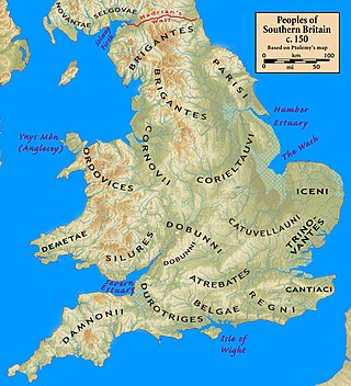
The Regni, Regini, or Regnenses were a tribe based largely on Sussex and which occupied modern West Sussex, East Sussex, south-west Kent, eastern Surrey, and the eastern edges of Hampshire. Their tribal centre was at Noviomagus Reginorum, close to Trisantona Fluvius which joined the English Channel at Littlehampton, a little way to the east of Noviomagus Reginorum. The tribe was bordered to the west by the Belgae, to the north by the Atrebates, and to the east by the Cantiaci, while much of their northern border was filled by the vast and near-impenetrable Weald Forest. Nevertheless, they were thinly scattered on either side of the Weald, and there were safe paths through the forest.

<span class="mw-page-title-main">Brigantes</span> British tribe of the Iron Age and Roman era

The Brigantes were Ancient Britons who in pre-Roman times controlled the largest section of what would become Northern England. Their territory, often referred to as Brigantia, was centred in what was later known as Yorkshire. The Greek geographer Ptolemy named the Brigantes as a people in Ireland also, where they could be found around what is now Wexford, Kilkenny and Waterford, while another people named Brigantii is mentioned by Strabo as a sub-tribe of the Vindelici in the region of the Alps.

<span class="mw-page-title-main">Caledonians</span> Celtic tribal confederacy in present-day Scotland during the Iron Age and Roman era

The Caledonians or the Caledonian Confederacy were a Brittonic-speaking (Celtic) tribal confederacy in what is now Scotland during the Iron Age and Roman eras. The Greek form of the tribal name gave rise to the name Caledonia for their territory. The Caledonians were considered to be a group of Britons, but later, after the Roman conquest of the southern half of Britain, the northern inhabitants were distinguished as Picts, thought to be a related people who would have also spoken a Brittonic language. The Caledonian Britons were thus enemies of the Roman Empire, which was the state then administering most of Great Britain as the Roman province of Britannia.

The Selgovae were a Celtic tribe of the late 2nd century AD who lived in what is now the Stewartry of Kirkcudbright and Dumfriesshire, on the southern coast of Scotland. They are mentioned briefly in Ptolemy's Geography, and there is no other historical record of them. Their cultural and ethnic affinity is commonly assumed to have been Brittonic.

<span class="mw-page-title-main">British Iron Age</span> Period of British prehistory predating the Roman occupation

The British Iron Age is a conventional name used in the archaeology of Great Britain, referring to the prehistoric and protohistoric phases of the Iron Age culture of the main island and the smaller islands, typically excluding prehistoric Ireland, which had an independent Iron Age culture of its own. The Iron Age is not an archaeological horizon of common artefacts but is rather a locally-diverse cultural phase.

<span class="mw-page-title-main">Hen Ogledd</span> Area of northern Britain, c. 500 to c. 800

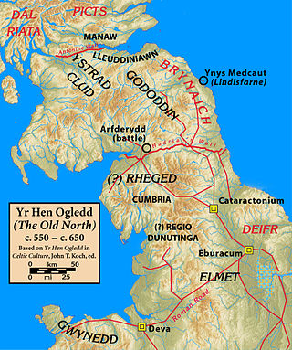
Yr Hen Ogledd, or in English the Old North, is the historical region that was inhabited by the Brittonic people of sub-Roman Britain in the Early Middle Ages, now Northern England and the southern Scottish Lowlands, alongside the Celtic Kingdom of Elmet. Its population spoke a variety of the Brittonic language known as Cumbric which is closely related to, if not a dialect of Old Welsh. The people of Wales and the Hen Ogledd considered themselves to be one people, and both were referred to as Cymry ('fellow-countrymen') from the Brittonic word combrogi. The Hen Ogledd was distinct from the parts of North Britain inhabited by the Picts, Anglo-Saxons, and Scoti.

<span class="mw-page-title-main">Damnonii</span> Brittonic people of the late 2nd century

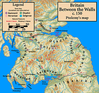
The Damnonii were a Brittonic people of the late 2nd century who lived in what became the Kingdom of Strathclyde by the Early Middle Ages, and is now southern Scotland. They are mentioned briefly in Ptolemy's Geography, where he uses both of the terms "Damnonii" and "Damnii" to describe them, and there is no other historical record of them, except arguably by Gildas three centuries later. Their cultural and linguistic affinity is presumed to be Brythonic. However, there is no unbroken historical record, and a partly Pictish origin is not precluded.

<span class="mw-page-title-main">Wales in the Roman era</span> Aspect of Welsh history

The Roman era in the area of modern Wales began in 48 AD, with a military invasion by the imperial governor of Roman Britain. The conquest was completed by 78 AD, and Roman rule endured until the region was abandoned in 383 AD.

<span class="mw-page-title-main">Manaw Gododdin</span> Part of the Brythonic-speaking Kingdom of Gododdin in the post-Roman Era

Manaw Gododdin was the narrow coastal region on the south side of the Firth of Forth, part of the Brythonic-speaking Kingdom of Gododdin in the post-Roman Era. It is notable as the homeland of Cunedda prior to his conquest of North Wales, and as the homeland of the heroic warriors in the literary epic Y Gododdin. Pressed by the Picts expanding southward and the Northumbrians expanding northward, it was permanently destroyed in the 7th century and its territory absorbed into the then-ascendant Kingdom of Northumbria.

The Description of Britain, also known by its Latin name De Situ Britanniae, was a literary forgery perpetrated by Charles Bertram on the historians of England. It purported to be a 15th-century manuscript by the English monk Richard of Westminster, including information from a lost contemporary account of Britain by a Roman general, new details of the Roman roads in Britain in the style of the Antonine Itinerary, and "an antient map" as detailed as the works of Ptolemy. Bertram disclosed the existence of the work through his correspondence with the antiquarian William Stukeley by 1748, provided him "a copy" which was made available in London by 1749, and published it in Latin in 1757. By this point, his Richard had become conflated with the historical Richard of Cirencester. The text was treated as a legitimate and major source of information on Roman Britain from the 1750s through the 19th century, when it was progressively debunked by John Hodgson, Karl Wex, B. B. Woodward, and John E. B. Mayor. Effects from the forgery can still be found in works on British history and it is generally credited with having named the Pennine Mountains.

The name Britain originates from the Common Brittonic term *Pritanī and is one of the oldest known names for Great Britain, an island off the north-western coast of continental Europe. The terms Briton and British, similarly derived, refer to some or all of its inhabitants and, to varying extents, those of the smaller islands in the vicinity. "British Isles" is the only ancient name for these islands to survive in general usage.

<span class="mw-page-title-main">Scotland during the Roman Empire</span> Aspect of Scottish history

Scotland during the Roman Empire refers to the protohistorical period during which the Roman Empire interacted within the area of modern Scotland. Despite sporadic attempts at conquest and government between the 1st and 4th centuries AD, most of modern Scotland, inhabited by the Caledonians and the Maeatae, was not incorporated into the Roman Empire with Roman control over the area fluctuating.

<span class="mw-page-title-main">Aeron (kingdom)</span>

Aeron was a kingdom of the Brythonic-speaking Hen Ogledd, presumed to have been located in the region of the River Ayr in what is now southwestern Scotland. It existed during the post-Roman era, perhaps earlier, and disappeared before or during the 7th-century conquest of the region by the ascendant Kingdom of Northumbria.

<span class="mw-page-title-main">Scottish island names</span>

The modern names of Scottish islands stem from two main influences. There are many names that derive from the Scottish Gaelic language in the Hebrides and Firth of Clyde. In the Northern Isles most place names have a Norse origin. There are also some island place names that originate from three other influences, including a limited number that are essentially English language names, a few that are of Brittonic origin and some of an unknown origin that may represent a pre-Celtic language. These islands have all been occupied by the speakers of at least three and in many cases four or more languages since the Iron Age, and many of the names of these islands have more than one possible meaning as a result.

References