Cross Anchor is a Census-designated place in Spartanburg County, South Carolina, United States. The population in the 2010 United States Census was 126.
Margarettsville, North Carolina, United States, is an unincorporated community in northern Northampton County. The community is part of the Roanoke Rapids, North Carolina Micropolitan Statistical Area. The ZIP Code for Margarettsville is 27853.
Martin is an unincorporated community in northwestern Allendale County, South Carolina, United States. It lies along SC 125 northwest of the town of Allendale, the county seat of Allendale County. Its elevation is 92 feet (28 m). Although Martin is unincorporated, it has a post office, with the ZIP code of 29836.
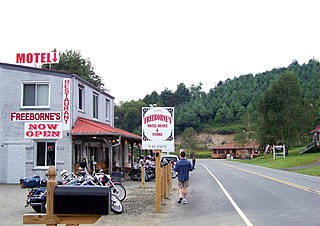
Wallace is a census-designated place and unincorporated community in northwestern Marlboro County, South Carolina, United States. It lies at the intersection of U.S. Route 1 with SC 9 and SC 177, northwest of the city of Bennettsville, the county seat of Marlboro County. Its elevation is 151&feet (46 m). Although Wallace is unincorporated, it has a post office, with the ZIP code of 29596; the ZCTA for ZIP code 29596 had a population of 2,606 at the 2000 census.
Sunbury is a census-designated place (CDP) and unincorporated community in Gates County, North Carolina, United States. As of the 2010 census, it had a population of 289.
Gates is an unincorporated community in Gates County, North Carolina, United States. Gates is located on North Carolina Highway 37, 7 miles (11 km) north of Gatesville. Gates has a post office with ZIP code 27937.
Little Rock is an unincorporated community and census-designated place (CDP) in Dillon County, South Carolina, United States. Per the 2020 census, the population was 658.

Adams Run is an unincorporated community and census-designated place (CDP) in Charleston County, South Carolina, United States. It was first listed as a CDP in the 2020 census with a population of 421.
Mill Spring is an unincorporated community in Polk County, North Carolina, United States. Mill Spring is located at the junction of North Carolina Highway 9 and North Carolina Highway 108 3.7 miles (6.0 km) northeast of Columbus. Mill Spring has a post office with ZIP code 28756. Mill Spring is named after Colonel Ambrose Mills. He founded a saw mill and post office in the community.
Glendale Springs is an unincorporated community in Ashe County, North Carolina, United States. Glendale Springs is located on North Carolina Highway 16, 7.3 miles (11.7 km) southeast of Jefferson. Glendale Springs has a post office with ZIP code 28629.
Laurel Springs is an unincorporated community in Alleghany County, North Carolina, United States. Laurel Springs is located at the junction of North Carolina Highway 18 and North Carolina Highway 88 near the Ashe County line, 10.2 miles (16.4 km) southwest of Sparta. The Blue Ridge Parkway also crosses the center of the community. Laurel Springs has a post office with ZIP code 28644.
Cliffside is an unincorporated community and census-designated place (CDP) in southeastern Rutherford County, North Carolina, United States. Its population was 611 as of the 2010 census. Cliffside has a post office with ZIP code 28024. U.S. Route 221 Alternate and North Carolina Highway 120 pass through the community.

South Mills is an unincorporated community and census-designated place (CDP) in Camden County, North Carolina, United States. Its population was 454 as of the 2010 census. South Mills has a post office with ZIP code 27976, which opened on March 2, 1840. The community is located near U.S. Route 17, and U.S. Route 17 Business and North Carolina Highway 343, and future Interstate 87 pass through the community.
Woodleaf is an unincorporated community in Unity Township, Rowan County, North Carolina, United States. The community is located on North Carolina Highway 801, 9.5 miles (15.3 km) northwest of Salisbury. Woodleaf has a post office with ZIP code 27054.
Council is an unincorporated community in Bladen County, North Carolina, United States. The community is located on North Carolina Highway 211, 7.9 miles (12.7 km) north-northwest of Bolton. Council has a post office with ZIP code 28434.
Willard is an unincorporated community in Pender County, North Carolina, United States. The community is located on North Carolina Highway 11, 3.3 miles (5.3 km) south-southeast of Wallace. Willard has a post office with ZIP code 28478.
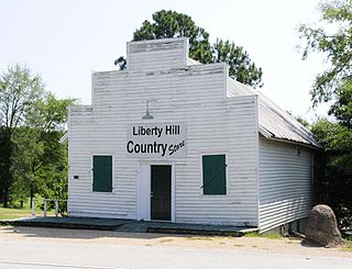
Liberty Hill is a scattered unincorporated community in Kershaw County, South Carolina, United States. The community is located along and either side of the junction of South Carolina Highway 97 and South Carolina Highway 522, 19.5 miles (31.4 km) northwest of Camden. Liberty Hill has a post office with ZIP code 29074, which opened on January 19, 1818. There is also a fire lookout tower there, and a church, and a few houses spread along the main road, but otherwise no businesses or services.
Pineville is an unincorporated community in Berkeley County, South Carolina, United States. The community is located on South Carolina Highway 45 6.3 miles (10.1 km) west-northwest of St. Stephen. Pineville has a post office with ZIP code 29468, which opened on March 19, 1880.

Tillman is an unincorporated community in Jasper County, South Carolina, United States. The community is located at the intersection of U.S. Route 321 and South Carolina Highway 336, 7.5 miles (12.1 km) west of Ridgeland. Tillman has a post office with ZIP code 29943, which opened on August 2, 1880.


