Meteorological history | |
---|---|
Formed | December 8,2017 |
Dissipated | December 18,2017 |
Category 2 "Minor"winter storm | |
Regional Snowfall Index:3.08 (NOAA) | |
Maximum snowfall or ice accretion | 25 in (64 cm) at Mount Mitchell,North Carolina |
Overall effects | |
Fatalities | 8 |
Injuries | ≥45 |
Damage | $1.06 million |
Areas affected | Southern,Mid-Atlantic,and Northeastern United States |
Power outages | >699,660 |
Part of the 2017–18 North American winter |
A winter storm,unofficially named Winter Storm Benji by The Weather Channel and Storm Zubin by the Free University of Berlin,impacted portions of the Southern,Mid-Atlantic,and Northeastern United States,and later across portions of Europe in December 2017. First developing as a low-pressure area in the Gulf of Mexico,the storm system impacted the Southern United States on December 8,producing rare snowfall totals and causing hazardous travel impacts across the South. The low then moved northeastward,reaching the Big Bend and western portions of Florida,while continuing to produce snowfall totals north of the low,across a narrow band stretching from Alabama to North Carolina. A second low-pressure area formed thereafter on December 9,producing additional snow totals across the East Coast of the United States,including portions of the Mid-Atlantic and Northeastern United States,before the low moved inland over Nova Scotia and The Maritimes the day after. After moving offshore,the low-pressure area strengthened,progressing over the northern Atlantic Ocean before moving over Sweden and Finland and subsequently dissipating.
The impacts of the winter storm in the Southern United States set numerous snowfall records across Texas and Louisiana and caused extensive damage to power infastructure and property damage that totaled $965,000,including $820,000 in Mississippi alone. Additionally,snowfall fell in the Florida panhandle,with snow flurries being reported as far south as Miramar Beach,Destin,and Pensacola. In southern Florida,severe weather also occurred after a squall line developed along a cold front,which produced wind damage that caused $50,000 in property damage across western and southern parts of the state. In the Mid-Atlantic and Northeastern United States,hundreds of vehicle accidents occurred from the heavy snowfall and resulted in New York City receiving its first major snowfall of the 2017–18 winter season. The low-pressure area associated with the winter storm also caused high winds across Germany and severe weather in Switzerland. Overall,the impacts from the winter storm killed eight people and injured at least 45 [lower-alpha 1] others.
On December 5,2017,a cold front moved through southern Texas,bringing rainfall and cold air behind it. [3] The front then intensified,which caused temperatures across the region to further decrease into the 40–50 °F (4–10 °C) range and resulted in the cooling of the atmosphere by December 7. [3] [4] On the same day,a separate cold front progressed across portions of the southern Great Plains and the Southeastern United States. [5] The combination of the atmospheric cooling,cold temperatures,and the cold front resulted in a wintry mix developing across southern Texas on December 7 and 8. [3] As the cold front progressed eastward,a broad area of southwesterly wind above the atmosphere developed in the Gulf of Mexico along an upper-level trough that was located across the southern Plains,as moisture was pulled into the trough. [5] [6] A low-pressure area developed in the Gulf of Mexico along a frontal boundary,and moved northeastward towards the Big Bend region in Florida. [5] [7] A zone of intense frontogenesis also formed north of the low-pressure area near the Texas coast,and moved northeast parallel to the low,producing heavy snowfall across a narrow area extending from east-central Alabama to northern Georgia to western North Carolina. [5]
As the low moved across the Southeastern United States on December 9,another low-pressure area developed along a surface front off the Carolina coast. [5] The second low tracked northward,producing additional snowfall across the Mid-Atlantic and the Northeastern United States,before moving inland across Nova Scotia on December 10. [5] The low-pressure area then reached a pressure of 983 millibars (29.0 inHg) while over The Maritimes in the late morning hours of December 10. [8] [9] As it moved northeast and continued to strengthen away from Newfoundland and Labrador on December 11,the low-pressure area traversed the northern Atlantic Ocean before moving inland over Sweden on December 15. [10] [11] It then moved over Finland on December 17 before dissipating on December 18. [12] [13] The winter storm was unofficially named Winter Storm Benji by The Weather Channel and Storm Zubin by Free University of Berlin,and was rated as a Category 2 in the United States with a Regional Snowfall Index of 3.077 by the National Oceanic and Atmospheric Administration. [10] [14] [15]
Icy conditions led to a 26-car collision on a Interstate 410 ramp near San Antonio on December 8,which injured one person and forced the closure of the ramp. [16] [17] Vehicle accidents also contributed to closures on Interstate 10 and Interstate 610. [18] Numerous highways and roads were covered in ice,including Interstate 10,Interstate 45,and Interstate 69,which created hazardous travel conditions. [19] There were several vehicle crashes across the Houston area. [20] [21] Snow fell across several major cities in the state,including in Austin,Houston,and San Antonio,and snow fell as far south as Brownsville,where a trace of snow fell on December 8,which was the second-ever measurable snowfall there and set a daily snowfall record. [22] [23] In addition,Corpus Christi received measurable snow,the first since 2004,and San Antonio received snowfall in December for the second time on record,which was also the second-earliest snowfall there. [24] [25] Additionally,measurable snow fell in Houston in December for the first time since 2009, [26] and daily snowfall records were broken on December 7 and 8. [27] The Beaumont-Port Arthur area received its first December snowfall ever,where 3 inches (7.6 cm) of snow fell,and was also tied for the second-highest snowfall total ever. [28] In Laredo,1.7 inches (4.3 cm) of snow accumulated,which set a snowfall record on December 8. [23] Multiple flights were delayed at Austin–Bergstrom International Airport, [29] where 1.3 inches (3.3 cm) of snow fell and the first snowfall in December since 1948, [28] and nearly 63,000 power outages occurred across Texas. [30] Several people contracted hypothermia that resulted from the cold temperatures and low wind chills caused by the winter storm,which killed three people and hospitalized two others. [31] Across the state,the winter weather impacts caused $85,000 in property damage. [32]
As a winter weather advisory was in effect for central portions of Louisiana, [33] Lafayette and Lake Charles recorded their snowiest December days on record,with 2.1 inches (5.3 cm) and 1.7 inches (4.3 cm) of snow respectively. [14] [24] Snow fell across the Baton Rouge area as well,covering vehicles with snow, [34] as 3.5 inches (8.9 cm) of snow fell,which was the third-highest total recorded there. [24] A trace of snow fell in New Orleans, [14] [35] as the state experienced below-freezing temperatures,causing ice to form,and resulted in seven casualties. [36] In Kentwood,6.5 inches (17 cm) of snow fell,the highest snowfall total across the state,while 5 inches (13 cm) of snow fell in Catahoula Parish southwest of Jonesville. [37] [38] [39] There were 63 vehicle crashes across St. Helena,St. Tammany,Tangipahoa,and Washington parishes, [40] and nearly 100,000 power outages occurred across the state. [41] Icy conditions on overpasses closed portions of Interstate 10, [42] and a curfew was set in Tangipahoa Parish as there were more than 29,000 power outages across the parish. [41] [43] Several shelters were opened in New Orleans,while a warming shelter was opened in St. Tammany Parish. [44] A motorcycle restriction was implemented on the Lake Pontchartrain Causeway bridge following the winter storm, [45] and in Catahoula Parish,property damage amounted to $10,000. [46] [47]
Winter storm warnings were issued for numerous counties in Mississippi as more than 6 inches (15 cm) fell across southwestern portions of the state. [48] Numerous school districts across the state were closed in preparation for the winter storm. [41] Jackson received 5.1 inches (13 cm) of snow,which was the sixth-highest snowfall total recorded there,while two locations separately in Jones and Lamar counties received 8 inches (20 cm) of snow. [14] [38] Additionally,5 inches (13 cm) of snow fell in Meridian,which was recorded as the third-highest snowfall accumulation on record. [24] [49] Across the state,there were nearly 80,000 power outages, [50] and there was $820,000 of property damage. [51]
Across Alabama,the heaviest snow fell across eastern portions of the state,mainly across Clay,Cleburne,and Randolph counties. [52] The heaviest snow in the state fell in Delta,where 15 inches (38 cm) was recorded,which was the seventh-highest snowfall in the state's history and the second-highest snowfall in December. [52] [53] In St. Clair County,6 inches (15 cm) of snow fell in Ragland,setting a county record for the highest snowfall accumulation in a day. [53] Prior to the winter storm,more than thirty-six school systems were closed. [41] There were several vehicle accidents on Interstate 65,including one which closed all southbound lanes of Interstate 65 in Shelby County,in Calera. [54] [55] Nearly 45,000 power outages occurred across the state,including nearly 10,000 outages across the Birmingham area. [56] [57] In Mobile,1 inch (2.5 cm) of snow fell,which was the earliest measurable snow there, [58] while 4 inches (10 cm) of snow fell at Birmingham–Shuttlesworth International Airport,which was the third-highest snowfall in December there. [58] As of December 2023,Birmingham has not seen more than 1 inch (2.5 cm) of snowfall. [59]
Before the winter storm impacted Georgia,winter storm warnings and advisories were in effect for numerous counties. [61] The heaviest snow fell across northern portions of the state,and the heavy snowfall caused extensive damage to power infrastructure. [60] A seven-vehicle crash closed all lanes of the Langford Parkway in Atlanta on December 8, [62] and numerous schools across the state,including schools across Metro Atlanta,were closed or dismissed early. [63] [64] There were nearly 1,600 flights cancelled and another 930 delayed at Atlanta International Airport, [65] [66] including the cancellation of more than 600 Delta Air Lines flights on December 8. [67] Additionally,there were more than 325,000 power outages across northern Georgia, [68] including more than 30,000 outages across the Atlanta metropolitan area. [64] One person was killed after being electrocuted from a downed power line. [69] During the winter storm,an emergency warming shelter was opened in Atlanta. [57] [70]
In preparation for the winter storm,several businesses,schools,and government offices were closed. [71] The full length of the Blue Ridge Parkway in North Carolina was closed,and North Carolina Highway 128 was also closed. [72] Additionally,Mount Mitchell State Park was closed, [72] and Asheville Mall,along with Asheville Outlets,opened late on December 8. [73] Two state football championship games were delayed;one between Wake Forest High School and Mallard Creek High School,and the other between Scotland High School and Harding University High School. [74] Two events that state governor Roy Cooper was scheduled to appear in were postponed. [75]
The heaviest snow fell across western portions of North Carolina,causing 54 vehicle accidents. [76] The total of vehicle accidents included one which injured two people and briefly closed all eastbound lanes of Interstate 40, [76] while another crash near Sylva that injured one person. [77] Another crash occurred at a shopping center in Burke County,which injured one person, [78] and several crashes occurred on the Triangle Expressway and on Interstate 540. [74] Delays occurred across several highways,including on Interstate 26 and Interstate 40, [76] and the heaviest snow for the winter storm and in the state fell on Mount Mitchell,where 25 inches (64 cm) was recorded. [79] Several flights were cancelled at Asheville Regional Airport, [80] and more than 39,000 power outages occurred across North Carolina. [81] A warming center was opened in the Asheville area by the American Red Cross. [71]
Snow fell as south as the Florida Panhandle,including across Escambia County,Florida,where snow fell in Molino and flurries were reported as far south as Miramar Beach,Destin,and Pensacola, [82] [66] [83] the latter location of which received a trace of snow. [84] Ice on a U.S. Route 29 bridge between McDavid and Century killed one person,and there were also several other vehicle crashes near the bridge. [85] Boat parades were cancelled across western Florida due to heavy rainfall,including parades in St. Petersburg and South Pasadena. [86] [87] Temperatures reached a high of 48 °F (9 °C) in St. Petersburg,and 61 °F (16 °C) in Miami. [88] The cold temperatures resulted in 16 cancelled flights and an additional 121 being delayed at Tampa International Airport. [89] A level 2/slight risk for severe weather was issued by the Storm Prediction Center on its Day 1 Outlook on December 8 across portions of western Florida,which also included a 5 percent tornado risk. [90] A squall line developed along a cold front that moved through western and southern parts of the state, [91] producing high wind gusts and causing $50,000 in property damage. [92] [93] A funnel cloud was also reported in Miami-Dade County. [94]
There were 660 power outages across the Greenville,South Carolina area, [88] and the highest snow fell in South Carolina near Cedar Mountain,where 9 inches (23 cm) of snow was reported. [14]
In Maryland,athletic events in Baltimore were postponed,along with school activities in numerous other counties. [95] [96] In preparation of the winter storm,Baltimore Department of Transportation crews were deployed,spreading more than 18,000 tons of salt across Baltimore County. [95] [97] Winter weather advisories were issued for portions of Maryland and Washington,D.C.,and winter storm warnings were in effect for southern Maryland. [98] Snow fell in December across Washington D.C. for the first time since 2013, [99] and snowfall records were broken at several locations across Maryland and Washington,D.C.,including at Baltimore/Washington International Airport,Dulles International Airport,and Ronald Reagan Washington National Airport. [95] [100]
Public school activities across several cities were cancelled in Virginia,including in Fairfax and Alexandria, [101] the latter of which also cancelled an ACT test across the city's school district. [98] The heaviest snow across the state fell in Henrico County,where Laurel received 5 inches (13 cm) of snow. [102] Two people were killed after a car crash, [79] and there were more than 200 vehicle crashes across the state,including one which shut down all lanes of Georgetown Pike after power lines were downed. [103] [104] About 18,000 power outages occurred across Virginia, [105] including 3,500 across northern portions of the state. [103] The winter storm also caused $95,000 in property damage. [106]
Prior to the winter storm,speed restrictions were implemented along the New Jersey Turnpike,Garden State Parkway,and Delaware River bridges, [107] [108] and Six Flags Great Adventure was closed in Jackson,New Jersey,along with a planned attempt at a world-record-breaking [108] snowball fight there. [109] In New Jersey,the majority of the state was under a winter storm advisory,while five counties were under a winter storm warning. [110] A nine-vehicle crash closed a ramp to U.S. Route 422 in Tredyffrin Township,Pennsylvania,while another vehicle crash closed a lane of Interstate 95 in Pennsylvania and caused delays. [107] Philadelphia broke its daily snowfall record on December 9,receiving 4.1 inches (10 cm) of snow,surpassing the previous record set in 1942. [111] Prior to the winter storm impacting New York,two facilities at Fordham University were closed. [112] Central Park received 4.6 inches (12 cm) of snow, [106] and New York City received its first major snowfall of the 2017–18 winter season. [113]
A speed restriction was implemented on the Massachusetts Turnpike,as vehicles slid off the Turnpike in Framingham,Massachusetts. [114] More than 2,100 crews were deployed by the Massachusetts Department of Transportation to treat roadways across the state, [114] and nearly 300 equipment pieces were deployed by Worcester,Massachusetts,Department of Public Works. [115] A parking ban was implemented in Worcester. [115] Across Massachusetts,the highest accumulation fell in Framingham,where 7.5 inches (19 cm) of snow fell, [116] while Arlington,received 7.2 inches (18 cm) of snow. [117] Boston received 6.1 inches (15 cm) of snow, [116] and numerous vehicle crashes occurred across Massachusetts,with several people being hospitalized. [2] A parking ban was also in place in Hampshire County,Massachusetts,where 65 vehicles were towed in Northampton. [118] There were also three vehicle crashes in Hampshire County. [118] In Connecticut,about 354 vehicle accidents occurred in nearly a 24-hour period,including 31 crashes with minor injuries. [1] There were also about 228 motorist incidents,and numerous crashes occurred across Bethel,Greenwich,and Ridgefield,Connecticut. [1] There were also several vehicle crashes and incidents of vehicles sliding off roads across Maine,including in Bangor and Auburn. [119] [120] Delays occurred at airports across the Northeast,including at Newark Liberty International Airport,John F. Kennedy International Airport,and Philadelphia International Airport. [104]
In southern Germany,wind gusts of 122 kilometres per hour (76 mph) occurred in Waibstadt,and there were reported winds of over 100 kilometres per hour (62 mph) in Munich. [121] Blowing snow and high winds contributed to numerous vehicle accidents across the Black Forest,and in the districts of Dachau,Fürstenfeldbruck,and Starnberg. [121] Felled trees caused train delays in Munich and Stuttgart,and a crane collapsed in Germering as a result of the high winds. [121] Flights were reportedly disrupted at Munich Airport,including one being cancelled,and eight people were injured. [121] [122]
Severe weather and high winds in Switzerland caused numerous felled and uprooted trees,some of which obstructed roads,and property damage in Baselland. [121] [122] A woman was killed in after high winds a tree fell on her while in a tent,which injured another person inside. [122] High winds also overturned barriers at multiple construction sites,and felled a tree onto a moving vehicle. [122] Fallen trees blocked transit lines in Bruderholz ,and numerous calls were made to Baselland public safety for assistance. [122]
The North American blizzard of 2006 was a nor'easter that began on the evening of February 11, 2006 and impacted much of eastern North America. It dumped heavy snow across the Mid-Atlantic and New England states, from Virginia to Maine through the early evening of February 12, and ended in Atlantic Canada on February 13. The major cities from Baltimore to Boston received at least a foot of snow, with a second-highest amount of 26.9 inches (68 cm) in New York City, the most since at least 1869, the start of record keeping, only broken by the January 2016 United States blizzard nearly 10 years later.
A historic snowstorm struck the Ohio Valley of the United States, as well as Ontario in Canada, on December 22 and December 23 and is not the same storm that led to snow in Texas on Christmas Eve. It lasted roughly 30 hours, and brought snowfall amounts up to 29 inches (74 cm) to portions of the Midwestern United States. Damages from the storm totaled US$900 million (2004 dollars). A total of 18 died during the storm, one from Canada, mainly due to car accidents.
The Mid-December 2007 North American winter storms were a series of two winter storms that affected much of central and eastern North America, from December 8 to December 18, 2007. The systems affected areas from Oklahoma to Newfoundland and Labrador with freezing rain, thunderstorms, sleet, snow, damaging winds, and blizzard-like conditions in various areas. The first two storms produced copious amounts of ice across the Midwestern United States and Great Plains from December 8 to December 11, knocking out power to approximately 1.5 million customers from Oklahoma north to Iowa. The second storm moved northeast, producing heavy snow across New York and New England. A third storm was responsible for a major winter storm from Kansas to the Canadian Maritimes, bringing locally record-breaking snowfalls to Ontario, an icestorm across the Appalachians, and thunderstorms and 9 tornadoes to the Southeastern United States.
The December 2009 North American blizzard was a powerful nor'easter that formed over the Gulf of Mexico in December 2009, and became a major snowstorm that affected the East Coast of the United States and Canadian Atlantic provinces. The snowstorm brought record-breaking December snowfall totals to Washington, D.C., Baltimore, and Philadelphia.
The February 9–10, 2010 North American blizzard was a winter and severe weather event that afflicted the Midwest, Mid-Atlantic and New England regions of the United States between February 9–11, 2010, affecting some of the same regions that had experienced a historic Nor'easter just three days earlier. The storm brought 10 to 20 inches of snow across a wide swath from Washington, D.C., to New York City, with parts of the Baltimore metro area receiving more than 20 inches (51 cm). This storm began as a classic "Alberta clipper", starting out in Canada and then moving southeast, and finally curving northeast while rapidly intensifying off the New Jersey coast, forming an eye. The National Weather Service likened this storm to a Category 1 hurricane: "Winds topped 58 mph over part of the Chesapeake Bay, and 40 mph gusts were common across the region as the storm's center deepened and drifted slowly along the mid-Atlantic coast". The storm system, in conjunction with the earlier storm, has been nicknamed "Snoverkill."
Global weather activity of 2007 profiles the major worldwide weather events, including blizzards, ice storms, tornadoes, tropical cyclones, and other weather events, from January 1, 2007, to December 31, 2007. Winter storms are events in which the dominant varieties of precipitation are formed during cold temperatures; they include snow or sleet, or a rainstorm where ground temperatures are cold enough to allow ice, including freezing rain, to form. Thehy may be marked by strong wind, thunder, lightning thunderstorms, heavy precipitation, including ice storm, wind transporting some substance through the atmosphere, including dust storms, snowstorms, and hail storms. Other major non winter events such as large dust storms, hurricanes, cyclones, tornados, gales, flooding, and rainstorms are also caused by such phenomena.
The 2012–13 North American winter started out somewhat early, as the remnants of Hurricane Sandy brought heavy snow to the mountains of West Virginia in late October. Later, a strong nor'easter affected the weary Northeastern United States, hampering storm recovery efforts and dropping several inches of snow. The rest of the winter featured several other notable events, such as a Christmas winter storm that affected most of the Eastern United States, and the most notable event occurring in early February, when a powerful blizzard struck the Northeast and brought record snow to some areas. During the winter, a weak El Nino was expected to influence weather conditions across the continent.
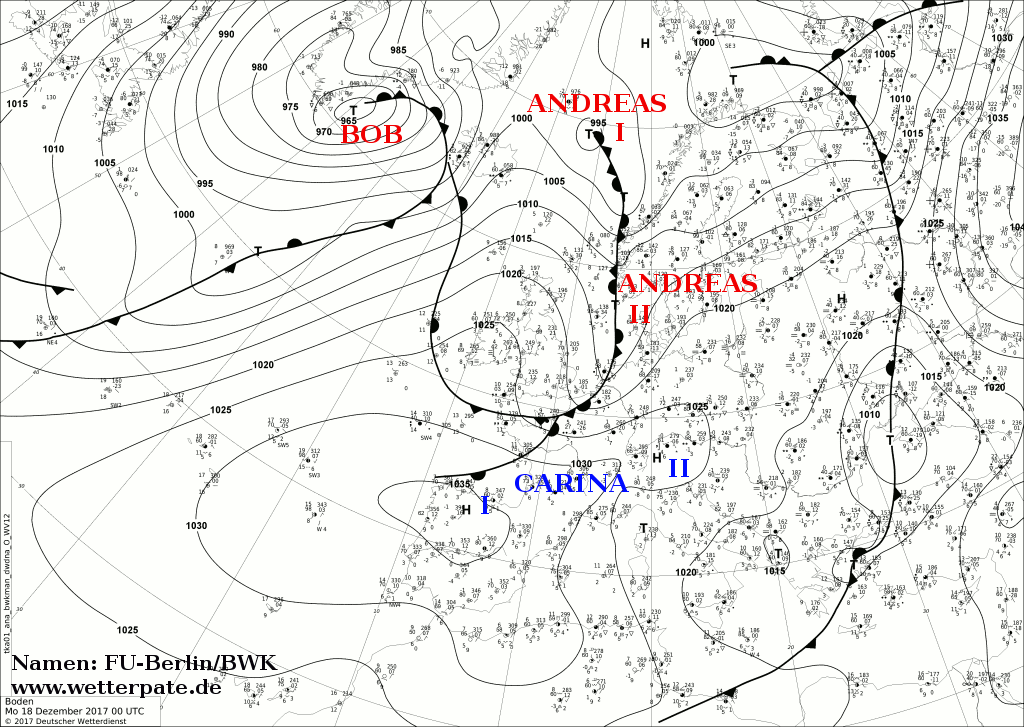
The 2017–18 North American winter saw weather patterns across North America that were very active, erratic, and protracted, especially near the end of the season, resulting in widespread snow and cold across the continent during the winter. Significant events included rare snowfall in the South, an outbreak of frigid temperatures that affected the United States during the final week of 2017 and early weeks of January, and a series of strong nor'easters that affected the Northeastern United States during the month of March. In addition, flooding also took place during the month of February in the Central United States. Finally the winter came to a conclusion with a powerful storm system that caused a tornado outbreak and blizzard in mid-April. The most intense event, however, was an extremely powerful cyclonic blizzard that impacted the Northeastern United States in the first week of 2018. Similar to the previous winter, a La Niña was expected to influence the winter weather across North America.
The 2018–19 North American winter was unusually cold within the Northern United States, with frigid temperatures being recorded within the middle of the season. Several notable events occurred, such as a rare snow in the Southeast in December, a strong cold wave and several major winter storms in the Midwest, and upper Northeast and much of Canada in late January and early February, record snowstorms in the Southwest in late February, deadly tornado outbreaks in the Southeast and a historic mid-April blizzard in the Midwest, but the most notable event of the winter was a record-breaking bomb cyclone that affected much of the Central United States and Canada in mid-March. Unlike previous winters, a developing weak El Niño was expected to influence weather patterns across North America. Overall, however, winter of 2018–19 was mild along the mid- and lower parts of the East Coast, the West Coast, and most of the southern Plains. Overall, the meteorological winter of 2018-19 became the wettest on record for the United States.
The January 2019 North American winter storm was a long-lived winter storm, forming as a large area of low pressure off the Pacific Northwest shoreline January 16, making its way to the Northeast by January 21. Its effects included heavy rain/high elevation snow and gusty winds in California, severe weather in the south, near-blizzard conditions in Upstate New York, an ice storm in New England and minor coastal flooding in the Mid-Atlantic.
The 2020–21 North American winter was the most significant winter season to affect North America in several years, and the costliest on record, with a damage total of at least $33.35 billion. The season featured 6 storms ranking on the Regional Snowfall Index scale (RSI), with 4 storms ranking as at least a Category 3. Most of the winter's damage and fatalities occurred due to a historic and major cold wave in mid-February. Several other significant events occurred, including a crippling early-season ice storm in the Southern Plains, a powerful nor'easter in mid-December, another major nor'easter in early February, two major and widespread winter storms in mid-February, and a major blizzard in the Rocky Mountains in mid-March. The winter-related events were responsible for at least 358 fatalities, making it the deadliest season since 1992–93. A La Niña pattern influenced much of the winter in North America.
The December 15–17, 2020 nor'easter was a powerful nor'easter that hammered the Northeastern United States and produced widespread swaths of over 1 foot (12 in) of snow in much of the region from December 15–17, 2020, ending a 1,000+ day high-impact snowstorm drought in much of the Mid-Atlantic and coastal New England regions. The system developed out of a weak area of low-pressure that first developed over the Central United States producing some snowfall before moving eastward, and by December 16, a new, dominant area of low pressure began to develop along the Southeast coast. This low steadily deepened as it moved along and impacted the Mid-Atlantic coastline, prompting several winter-related advisories and warnings for much of the Northeast.
The February 15–20, 2021 North American winter storm, also unofficially referred to as Winter Storm Viola, was a significant and widespread snow and ice storm across much of the United States, Northern Mexico, and Southern Canada. The system started out as a winter storm on the West Coast of the United States on February 15, later moving southeast into the Southern Plains and Deep South from February 16–17. It then moved into the Appalachian Mountains and Northeastern United States, before finally moving out to sea on February 20. The storm subsequently became a powerful low pressure system over the North Atlantic, before eventually dissipating on February 26.
The 2021–22 North American winter was not as significant and record-breaking as the previous winter season. Despite this, several notable and significant events still occurred, including two separate record-breaking tornado outbreaks in mid-December, a significant winter storm in the South in mid-January, a powerful blizzard that impacted the Northeast coast at the end of January and a wide-ranging, significant winter storm that affected most of the eastern half of the country in early February. Additional significant events included a late-season winter storm in March that affected the Appalachian Mountains, and a major blizzard that affected North and South Dakota in mid-April. Additionally, a very late out-of-season snowstorm struck the Rocky Mountains in late May. During the season, four storms have been ranked on the Regional Snowfall Index (RSI), although none attained the “Major” category. Similar to the previous winter, a developing La Niña was expected to influence weather patterns across the continent.
The January 14–17, 2022 North American winter storm brought widespread impacts and wintry precipitation across large sections of eastern North America and parts of Canada. Forming out of a shortwave trough on January 13, it first produced a swath of snowfall extending from the High Plains to the Midwestern United States. The storm eventually pivoted east and impacted much of the Southern United States from January 15–16 before shifting north into Central Canada, the Mid-Atlantic states, and the Northeastern United States. The system, named Winter Storm Izzy by The Weather Channel, was described as a "Saskatchewan Screamer".
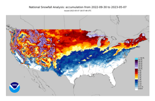
The 2022–23 North American winter was an unusually warm winter for the east and an unusually cold winter for the west in North America, as it occurred across the continent from late 2022 to early 2023. The winter season in North America began at the winter solstice, which occurred on December 21, 2022, and it ended at the March equinox, which occurred on March 20, 2023. The first day of meteorological winter began on December 1 and unofficially ended on February 28; winter storms may still occur outside of these limits.
The November 2022 Great Lakes winter storm was a lake-effect winter storm that affected parts of Pennsylvania, Ohio, and New York. The winter storm caused high accumulations of snow across the Great Lakes region, with several locations receiving 50 in (130 cm) of snowfall across New York, with Hamburg, New York receiving 81.2 in (206 cm) and Orchard Park, New York recording 80 in (200 cm) of snow. At least four fatalities occurred, with three in New York and one in Indiana, and several highways closed after heavy snowfall. A travel ban was also issued for New York by governor Kathy Hochul, and thundersnow occurred across areas impacted by the winter storm.
A winter storm in March 2023 impacted much of the Western, Northern, and Northeastern United States, producing high snowfall totals and widespread damage across the region. The winter storm, unofficially named Winter Storm Sage by The Weather Channel, first progressed across the Western United States as an atmospheric river, and then moved across the northern United States, bringing blizzard conditions and moderate snowfall across the Northern U.S.. The winter storm then became a nor'easter and impacted the Northeast, bringing snowfall rates of 1–2 inches (2.5–5.1 cm) per hour across numerous locations across the Northeast and 3 feet (36 in) of snow in several locations across the region with locally higher amounts. More than 320,000 power outages occurred across the areas impacted by the winter storm, and caused three fatalities and two injuries. Readsboro, Vermont received 42.1 inches (107 cm) of snow, and nearly 200 car accidents occurred across the New England region in the Northeast.
A winter storm, unofficially named Winter Storm Skylar by The Weather Channel, brought widespread blizzard conditions across the Northeastern United States, particularly New England in mid-March 2018. First impacting the Midwestern and Southern United States on March 11–12, causing travel impacts and producing high snowfall totals, the winter storm then moved into the Northeastern United States and became a nor'easter, producing blizzard conditions and heavy snowfall across portions of the interior Northeast on March 13–15. Heavy snow fell in Massachusetts, where most of the state received at least one foot of snow; the storm brought the heaviest March snow on record in Boston and Worcester. Over two feet of snow were reported in portions of Massachusetts, peaking at 31 inches (79 cm) in Wilmington. Heavy snow also fell in Rhode Island, where the snowfall peaked at 25.1 inches (64 cm) in Foster.
The 2023–24 North American winter was the warmest winter on record across the contiguous United States, with below-average snowfall primarily in the Upper Midwest and parts of the Northeastern United States. However, some areas, especially in the states of Pennsylvania, New Jersey and New York saw considerably more snow than the previous winter. Notable winter events were also more prevalent across the eastern half of the country this winter, including a series of winter storms in mid-January that brought snow from the South to Northeast states, a period of very cold temperatures across much of the country in mid-to-late January, and a disruptive nor'easter that affected much of the Mid-Atlantic in mid-February. 2 storms have been rated so far on the Regional Snowfall Index (RSI), although none have attained a "Major" rating. A strong El Niño was expected to influence the winter weather patterns across the continent.