St. Clair County, Alabama

Last updated

St. Clair County
St. Clair County Courthouse in Pell City, Alabama.JPG
St. Clair County Courthouse in Pell City
Flag of St. Clair County, Alabama.svg
Map of Alabama highlighting St. Clair County.svg
Location within the U.S. state of Alabama
Alabama in United States.svg
Alabama's location within the U.S.
Coordinates: 33°42′57″N86°19′05″W / 33.71583°N 86.31806°W / 33.71583; -86.31806
CountryFlag of the United States.svg United States
StateFlag of Alabama.svg  Alabama
FoundedNovember 20, 1818 [1]
Named for Arthur St. Clair
Seat Ashville & Pell City
Largest city Moody
Area
  Total654 sq mi (1,690 km2)
  Land632 sq mi (1,640 km2)
  Water22 sq mi (60 km2)  3.3%
Population
 (2020)
  Total91,103
  Estimate 
(2023)
95,552 Increase2.svg
  Density140/sq mi (54/km2)
Time zone UTC−6 (Central)
  Summer (DST) UTC−5 (CDT)
Congressional district 3rd
Website www.stclairco.com
  • County Number 59 on Alabama Licence Plates

St. Clair County is a county located in the central portion of the U.S. state of Alabama. [1] As of the 2020 census, the population was 91,103. [2] It has two county seats: Ashville and Pell City. [3] It is one of two counties in Alabama, and one of 33 in the United States, with more than one county seat. Its name is in honor of General Arthur St. Clair, an officer in the French and Indian War. [1] St. Clair County is included in the Birmingham, Alabama Metropolitan Statistical Area.

Contents

History

St. Clair County was established on November 20, 1818, by the Alabama Territory legislature by splitting the area from Shelby County. [1] [4] The county seat was incorporated and named "Ashville" in honor of John Ash. [1] In 1836, a portion of St. Clair County was separated to establish Cherokee County and DeKalb County. In 1866, after the Civil War, a northeast section of the county was used to create Etowah County. [1]

Due to the relatively high terrain of the far southern end of the Appalachian Mountains which divides the county in a northeast–southwest orientation, and the difficulty of communication and administration from either side of the county to the other, a second county seat was established in Pell City to better provide administration and services to the southeast side of the county. [5]

In 2019, St. Clair County became the seventh county in Alabama to adopt its own flag. [6]

Geography

According to the United States Census Bureau, the county has a total area of 654 square miles (1,690 km2), of which 632 square miles (1,640 km2) is land and 22 square miles (57 km2) (3.3%) is water. [7]

Adjacent counties

Demographics

Historical population
CensusPop.Note
1820 4,166
1830 5,97543.4%
1840 5,638−5.6%
1850 6,82921.1%
1860 11,01361.3%
1870 9,360−15.0%
1880 14,46254.5%
1890 17,35320.0%
1900 19,42511.9%
1910 20,7156.6%
1920 23,38312.9%
1930 24,5104.8%
1940 27,33611.5%
1950 26,687−2.4%
1960 25,388−4.9%
1970 27,95610.1%
1980 41,20547.4%
1990 50,00921.4%
2000 64,74229.5%
2010 83,59329.1%
2020 91,1039.0%
2023 (est.)95,552 [8] 4.9%
U.S. Decennial Census [9]
1790–1960 [10] 1900–1990 [11]
1990–2000 [12] 2010–2020 [2]

2020 census

St. Clair County, Alabama – Racial and Ethnic Composition
(NH = Non-Hispanic)
Note: the US Census treats Hispanic/Latino as an ethnic category. This table excludes Latinos from the racial categories and assigns them to a separate category. Hispanics/Latinos may be of any race.
Race / EthnicityPop 2000 [13] Pop 2010 [14] Pop 2020 [15] % 2000% 2010% 2020
White alone (NH)57,91772,94774,96289.46%87.26%82.28%
Black or African American alone (NH)5,2537,0988,6178.11%8.49%9.46%
Native American or Alaska Native alone (NH)2332522490.36%0.30%0.27%
Asian alone (NH)1085126550.17%0.61%0.72%
Pacific Islander alone (NH)1741200.03%0.05%0.02%
Some Other Race alone (NH)16642340.02%0.08%0.26%
Mixed Race/Multi-Racial (NH)5129633,7910.79%1.15%4.16%
Hispanic or Latino (any race)6861,7162,5751.06%2.05%2.83%
Total64,74283,59391,103100.00%100.00%100.00%

As of the census of 2020, there were 91,103 people, 32,829 households, and 25,409 families residing in the county.

2010 census

As of the census of 2010, there were 83,593 people, 31,624 households, and 23,364 families living in the county. The population density was 132 people per square mile (51 people/km2). There were 35,541 housing units at an average density of 56 units per square mile (22 units/km2). The racial makeup of the county was 88.2% White, 8.6% Black or African American, 0.3% Native American, 0.6% Asian, 0.1% Pacific Islander, 0.9% from other races, and 1.3% from two or more races. 2.1% of the population were Hispanic or Latino of any race. [16] Of the 31,624 households 30.7% had children under the age of 18 living with them, 58.3% were married couples living together, 11.2% had a female householder with no husband present, and 26.1% were non-families. 22.5% of households were one person and 8.5% were one person aged 65 or older. The average household size was 2.58 and the average family size was 3.02.

The age distribution was 23.7% under the age of 18, 7.8% from 18 to 24, 27.8% from 25 to 44, 27.6% from 45 to 64, and 13.1% 65 or older. The median age was 38.6 years. For every 100 females, there were 100.5 males. For every 100 females age 18 and over, there were 102.3 males.

The median household income was $48,837 and the median family income was $56,107. Males had a median income of $43,287 versus $32,843 for females. The per capita income for the county was $22,192. About 8.3% of families and 10.6% of the population were below the poverty line, including 13.2% of those under age 18 and 9.5% of those age 65 or over.

2000 census

As of the census of 2000, there were 64,742 people, 24,143 households, and 18,445 families living in the county. The population density was 102 people per square mile (39 people/km2). There were 27,303 housing units at an average density of 43 units per square mile (17 units/km2). The racial makeup of the county was 90.03% White, 8.13% Black or African American, 0.37% Native American, 0.17% Asian, 0.03% Pacific Islander, 0.41% from other races, and 0.85% from two or more races. 1.06% of the population were Hispanic or Latino of any race. [17] In 2000 the largest ancestry groups in St. Clair county were:

Of the 24,143 households 35.10% had children under the age of 18 living with them, 62.80% were married couples living together, 10.00% had a female householder with no husband present, and 23.60% were non-families. 20.80% of households were one person and 8.20% were one person aged 65 or older. The average household size was 2.60 and the average family size was 3.01.

The age distribution was 25.40% under the age of 18, 7.90% from 18 to 24, 30.70% from 25 to 44, 24.30% from 45 to 64, and 11.70% 65 or older. The median age was 36 years. For every 100 females, there were 101.80 males. For every 100 females age 18 and over, there were 98.80 males.

The median household income was $37,285 and the median family income was $43,152. Males had a median income of $33,914 versus $24,433 for females. The per capita income for the county was $17,960. About 9.60% of families and 12.10% of the population were below the poverty line, including 15.20% of those under age 18 and 12.60% of those age 65 or over.

Places of interest

St. Clair County is home to Logan Martin Lake. It also contains Horse Pens 40, a private outdoor park on top of Chandler Mountain.

Government

United States presidential election results for St. Clair County, Alabama [18]
Year Republican Democratic Third party
No.%No.%No.%
2020 36,16681.38%7,74417.43%5311.19%
2016 31,65182.42%5,58914.55%1,1603.02%
2012 29,03182.39%5,80116.46%4031.14%
2008 27,64981.11%6,09117.87%3481.02%
2004 23,50080.59%5,45618.71%2050.70%
2000 17,11771.05%6,48526.92%4882.03%
1996 12,76262.29%6,18730.20%1,5407.52%
1992 12,44757.56%6,51730.14%2,66012.30%
1988 10,60470.71%4,33528.91%580.39%
1984 10,40871.02%4,00027.30%2461.68%
1980 7,76856.89%5,23638.35%6504.76%
1976 4,87744.87%5,65352.01%3393.12%
1972 6,95279.82%1,53817.66%2202.53%
1968 1,63516.86%8698.96%7,19374.18%
1964 4,81370.76%00.00%1,98929.24%
1960 2,58945.90%3,03953.88%120.21%
1956 2,44149.07%2,42048.64%1142.29%
1952 1,59040.54%2,32659.31%60.15%
1948 1,06335.67%00.00%1,91764.33%
1944 1,11737.86%1,81961.66%140.47%
1940 1,54038.27%2,46261.18%220.55%
1936 1,46437.73%2,39961.83%170.44%
1932 1,44939.43%2,18559.46%411.12%
1928 2,58166.25%1,31333.70%20.05%
1924 1,43250.64%1,28145.30%1154.07%
1920 2,56155.04%1,93441.56%1583.40%
1916 85144.81%98751.97%613.21%
1912 26014.37%78743.50%76242.12%
1908 78243.59%82045.71%19210.70%
1904 59330.55%90846.78%44022.67%

Communities

Cities

Towns

Unincorporated communities

Former towns

Transportation

Major highways

Rail

Historically, the Southern Railway ran several daily passenger trains, including the Kansas City-Florida Special and an Atlanta-Birmingham section of the Piedmont Limited, making stops in Pell City. The Sunnyland made signal stops as well. [19] The last trains made stops in 1967. [20] [21] Today, the nearest passenger service is Amtrak's Crescent in Anniston 30.6 miles to the east.

See also

Related Research Articles

<span class="mw-page-title-main">Blount County, Alabama</span> County in Alabama, United States

Blount County is a county located in the U.S. state of Alabama. As of the 2020 census, the population was 59,134. Its county seat is Oneonta.

<span class="mw-page-title-main">Calhoun County, Alabama</span> County in Alabama, United States

Calhoun County is a county in the east central part of the U.S. state of Alabama. As of the 2020 census, the population was 116,441. Its county seat is Anniston. It is named in honor of John C. Calhoun, a US Senator from South Carolina.

<span class="mw-page-title-main">Chilton County, Alabama</span> County in Alabama, United States

Chilton County is a county located in the central portion of the U.S. state of Alabama. As of the 2020 census, the population was 45,014. The county seat is Clanton. Its name is in honor of William Parish Chilton, Sr. (1810–1871), a lawyer who became Chief Justice of the Alabama Supreme Court and later represented Montgomery County in the Congress of the Confederate States of America.

<span class="mw-page-title-main">Etowah County, Alabama</span> County in Alabama, United States

Etowah County is a county located in the northeastern part of the U.S. state of Alabama. As of the 2020 census the population was 103,436. Its county seat is Gadsden. Its name is from a Cherokee word meaning "edible tree". In total area, it is the smallest county in Alabama, but one of the most densely populated. Etowah County comprises the Gadsden Metropolitan Statistical Area.

<span class="mw-page-title-main">Morgan County, Alabama</span> County in Alabama, United States

Morgan County is a county in the north-central part of the U.S. state of Alabama. As of the 2020 census, its population was 123,421. The county seat is Decatur. On June 14, 1821, it was renamed in honor of American Revolutionary War General Daniel Morgan of Virginia. It is a prohibition or dry county, although alcohol sales are allowed in the cities of Decatur, Hartselle, and Priceville. Morgan County is included in the Decatur, AL Metropolitan Statistical Area, which is also included in the Huntsville-Decatur-Albertville, AL Combined Statistical Area. It is a part of the North, Northwest, and North-Central regions of Alabama.

<span class="mw-page-title-main">Coosa County, Alabama</span> County in Alabama, United States

Coosa County is located in the east central portion of the U.S. state of Alabama. As of the 2020 census the population was 10,387. Its county seat is Rockford. Its name derives from a town of the Creek tribe and the Coosa River, which forms one of the county borders.

<span class="mw-page-title-main">Franklin County, Alabama</span> County in Alabama, United States

Franklin County is a county located in the U.S. state of Alabama. As of the 2020 census, the population was 32,113. Its county seat is Russellville. Its name is in honor of Benjamin Franklin, famous statesman, scientist, and printer. It is a dry county, although the city of Russellville is wet.

<span class="mw-page-title-main">Shelby County, Alabama</span> County in Alabama, United States

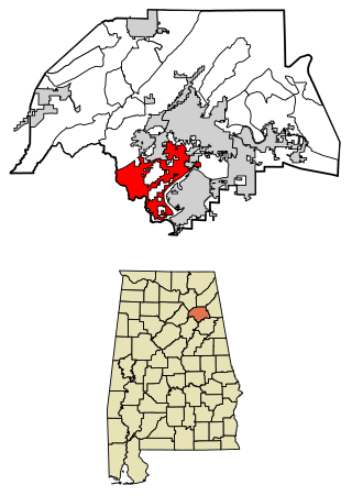
Shelby County is located in the central portion of the U.S. state of Alabama. As of the 2020 census the population was 223,024, making it the sixth-most populous county in Alabama. The county seat is Columbiana. Its largest city is Alabaster. The county is named in honor of Isaac Shelby, Governor of Kentucky from 1792 to 1796 and again from 1812 to 1816. Shelby County is included in the Birmingham–Hoover, AL Metropolitan Statistical Area.

<span class="mw-page-title-main">Talladega County, Alabama</span> County in Alabama, United States

Talladega County is one of the sixty-seven counties located in the east central portion of the U.S. state of Alabama. As of the 2020 census, the population was 82,149. Its county seat is Talladega.

<span class="mw-page-title-main">Tallapoosa County, Alabama</span> County in Alabama, United States

Tallapoosa County is located in the east-central portion of the U.S. state of Alabama. As of the 2020 census, the population was 41,311. Its county seat is Dadeville. Its largest city is Alexander City.

<span class="mw-page-title-main">Walker County, Alabama</span> County in Alabama, United States

Walker County is a county located in the central portion of the U.S. state of Alabama. As of the 2020 census, the population was 65,342. Its county seat is Jasper. Its name is in honor of John Williams Walker, the first U.S. senator elected from Alabama.

<span class="mw-page-title-main">St. Clair County, Missouri</span> County in Missouri, United States

St. Clair County is a county located in the western portion of the U.S. state of Missouri. As of the 2020 census, the population was 9,284. Its county seat is Osceola. The largest city is Appleton City. The county was organized in 1841 and named after General Arthur St. Clair, Governor of the Northwest Territory. St. Clair was also the 9th president of the United States in Congress Assembled. Under his presidency, the Northwest Ordinance and United States Constitution were passed.

<span class="mw-page-title-main">Calera, Alabama</span> City in Alabama, United States

Calera is a city in Shelby and Chilton counties in the U.S. state of Alabama. It is the location of the Shelby County Airport.

<span class="mw-page-title-main">Rainbow City, Alabama</span> City in Alabama, United States

Rainbow City is a city in Etowah County, Alabama, United States. It incorporated in 1950. The population was 9,602 at the 2010 census. It is part of the Gadsden Metropolitan Statistical Area.

<span class="mw-page-title-main">Pelham, Alabama</span> City in Alabama, United States

Pelham is a city in Shelby County, Alabama, United States. The population was 24,318 at the 2020 census, It incorporated on July 10, 1964 and is a suburb located in the Birmingham metropolitan area, Alabama which was home to nearly 1.2 million residents as of the 2020 census. It was named for Confederate Civil War officer John Pelham.

<span class="mw-page-title-main">Vincent, Alabama</span> City in Alabama, United States

Vincent, originally known as Propel, is a city in Shelby, St. Clair, and Talladega counties in the U.S. state of Alabama. At the 2020 census, the population was 1,982. The community was first known as Propel, but later named Vincent in honor of the Vincent family, who were early settlers of the area. It was incorporated in 1897.

<span class="mw-page-title-main">Ashville, Alabama</span> City in and county seat of St. Clair County, Alabama

Ashville is a city in and one of the county seats of St. Clair County, Alabama, United States, other seat being Pell City. Its population was 2,212 at the 2010 census, down from 2,260, at which time it was a town. It incorporated in 1822.

<span class="mw-page-title-main">Moody, Alabama</span> City in Alabama

Moody is a city located in St. Clair County, Alabama. The city was founded in 1907, and it was named after a local businessman named Epps Moody. It is located about 22 miles east of Birmingham and has a population of approximately 12,000 people. The city covers an area of 24.5 square miles, with a land area of 24.3 square miles and a water area of 0.2 square miles.

<span class="mw-page-title-main">Pell City, Alabama</span> City in Alabama, United States

Pell City is a city in and one of the county seats of St. Clair County, Alabama, United States, the other seat being Ashville. At the 2020 census, the population was 12,939. At the 2010 census, the city-limit population jumped to 12,695.

<span class="mw-page-title-main">Tavares, Florida</span> City in Florida

Tavares is a city and the county seat of Lake County, Florida. The population at the 2020 census was 19,003, and in 2019 the population was estimated to be 17,749. It is part of the Orlando–Kissimmee–Sanford Metropolitan Statistical Area.

References

  1. 1 2 3 4 5 6 "ACES Winston County Office" (links/history), Alabama Cooperative Extension System (ACES), 2007, webpage: ACES-St.Clair.
  2. 1 2 "State & County QuickFacts". United States Census Bureau. Retrieved September 14, 2023.
  3. "Find a County". National Association of Counties. Retrieved June 7, 2011.
  4. A digest of the laws of the State of Alabama: containing the statutes and resolutions in force at the end of the General Assembly in January, 1823. Published by Ginn & Curtis. New York, 1828. Title 10. Chapter XIX. pp. 88-89. "An Act to alter and ascertain more particularly the Boundaries of the County of Shelby and to lay off a new County in the northeast part thereof, to be called and known by the name of St. Clair CountyPassed November 20 1818." (Google Books)
  5. James Spann. Television broadcast on WBMA-LD (ABC 33/40). Birmingham, AL. March 25, 2021.
  6. ghanner@thestclairtimes.com, Gary Hanner, St Clair Times editor (September 11, 2019). "St. Clair County Commission approves county flag". The Anniston Star. Retrieved June 11, 2023.{{cite web}}: |first= has generic name (help)CS1 maint: multiple names: authors list (link)
  7. "2010 Census Gazetteer Files". United States Census Bureau. August 22, 2012. Retrieved August 22, 2015.
  8. "Annual Estimates of the Resident Population for Counties: April 1, 2020 to July 1, 2023". United States Census Bureau. Retrieved March 27, 2024.
  9. "U.S. Decennial Census". United States Census Bureau. Retrieved August 22, 2015.
  10. "Historical Census Browser". University of Virginia Library. Retrieved August 22, 2015.
  11. Forstall, Richard L., ed. (March 24, 1995). "Population of Counties by Decennial Census: 1900 to 1990". United States Census Bureau. Retrieved August 22, 2015.
  12. "Census 2000 PHC-T-4. Ranking Tables for Counties: 1990 and 2000" (PDF). United States Census Bureau. April 2, 2001. Retrieved August 22, 2015.
  13. "P004 HISPANIC OR LATINO, AND NOT HISPANIC OR LATINO BY RACE – 2000: DEC Summary File 1 – St. Clair County, Alabama". United States Census Bureau .
  14. "P2 HISPANIC OR LATINO, AND NOT HISPANIC OR LATINO BY RACE – 2010: DEC Redistricting Data (PL 94-171) – St. Clair County, Alabama". United States Census Bureau .
  15. "P2 HISPANIC OR LATINO, AND NOT HISPANIC OR LATINO BY RACE - 2020: DEC Redistricting Data (PL 94-171) – St. Clair County, Alabama". United States Census Bureau .
  16. "U.S. Census website". United States Census Bureau . Retrieved August 8, 2015.
  17. "U.S. Census website". United States Census Bureau . Retrieved May 14, 2011.
  18. "Dave Leip's Atlas of U.S. Presidential Elections" . Retrieved November 21, 2016.
  19. Southern Railway timetable, 1952, Table 1, https://streamlinermemories.info/South/SOU52TT.pdf
  20. "Southern Railway, Table 2, [final appearance of train]". Official Guide of the Railways. 99 (7). National Railway Publication Company. December 1966.
  21. "Southern Railway, Table 2, [struck from schedule]". Official Guide of the Railways. 100 (2). National Railway Publication Company. July 1967.

33°42′57″N86°19′05″W / 33.71583°N 86.31806°W / 33.71583; -86.31806