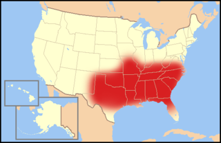
South Alabama and Lower Alabama are overlapping, poorly-defined terms for various parts of southern Alabama. Although it is not a strictly defined geographic region, it generally includes all Alabama counties south of the Black Belt. In that view, South Alabama consists of just the two counties that border the Gulf of Mexico and Mobile Bay: Baldwin County and Mobile County. That area is characterized by extensive wetlands, but also by long, sandy beaches which are very conducive to tourism. Many deluxe golf courses have been developed in the area in recent decades.
Because Mobile and Baldwin Counties tend to use "South Alabama" with such exclusivity, other parts of southern Alabama, particularly the Florida-border counties from Escambia County over to Houston County often humorously prefer to be called Lower Alabama if a regional name must be given. Traditionally the south central and southeastern parts of the state have less in common with the Mobile area than they have in common with southwest Georgia and the Black Belt region. Alternative names include South Central Alabama, Southeast Alabama, and the Wiregrass.
Because there is no formally defined border, there are three overlapping areas generally referred to as Lower Alabama:
In the vicinity of Mobile, Alabama, the argument is that it refers only to the southernmost parts of Alabama. This usage insists that it is properly applied only to the two counties which border the Gulf of Mexico and Mobile Bay: Baldwin County and Mobile County. This area is characterized by extensive wetlands, but also by long, sandy beaches which are very conducive to tourism. Many deluxe golf courses have been developed in the area in recent decades. However, this region more commonly takes South Alabama as a better-known name for the region. This is reflected in the name of the University of South Alabama located in Mobile.
It includes the area all the way up from Troy to all the way south to Mobile.
Because Mobile and Baldwin Counties tend to use South Alabama with exclusivity, a second use of "Lower Alabama" is to refer to the other parts of southern Alabama, including the Florida-border counties from Escambia County east to Houston County. Traditionally, the south central and southeastern parts of the state are representative of an older era in Alabama. Hence, Lower Alabama, suggests that this region is less wealthy than other parts of the state. It includes the cities of Dothan, Luverne, Troy, Abbeville, Eufaula, and Cowarts. These sections of the state are where jokes are often heard with punch lines of "Yep, I'm from L.A. too: Lower Alabama" (this can be heard in the 1971 James Brown single "Escape-ism.") Further evidence of this region's claim was the "University of Lower Alabama" as one of the considered name changes by Troy State University before it became Troy University.
The geography of Alabama describes a state in the Southeastern United States in North America. It extends from high mountains to low valleys and sandy beaches. Alabama is 30th in size and borders four U.S. states: Mississippi, Tennessee, Georgia, and Florida. It also borders the Gulf of Mexico.
Local access and transport area (LATA) is a term used in U.S. telecommunications regulation. It represents a geographical area of the United States under the terms of the Modification of Final Judgment (MFJ) entered by the United States District Court for the District of Columbia in Civil Action number 82-0192 or any other geographic area designated as a LATA in the National Exchange Carrier Association, Inc. Tariff FCC No. 4. that precipitated the breakup of the original AT&T into the "Baby Bells" or created since that time for wireline regulation.
Baldwin County is a county located in the southwestern part of the U.S. state of Alabama, on the Gulf coast. It is one of only two counties in Alabama that border the Gulf of Mexico, along with Mobile County. As of the 2020 census, the population was 231,767, making it the fourth-most populous county in Alabama. The county seat is Bay Minette. The county is named after the founder of the University of Georgia, Senator Abraham Baldwin.
Escambia County is a county located in the south central portion of the U.S. state of Alabama. As of the 2020 census, the population was 36,757. Its county seat is Brewton.
The Bible Belt is a region of the Southern United States and one Midwestern state, the state of Missouri, in all of which socially conservative Protestant Christianity plays a strong role in society. Church attendance across the denominations is generally higher than the nation's average. The region contrasts with the religiously diverse Midwest and Great Lakes, and the Mormon corridor in Utah and southern Idaho.
The Southeastern United States, also referred to as the American Southeast, the Southeast, or the South, is a geographical region of the United States located in the eastern portion of the Southern United States and the southern portion of the Eastern United States. The region includes a core of states that reaches north to Maryland and West Virginia, bordering the Ohio River and Mason–Dixon line, and stretches west to Arkansas and Louisiana.
The Florida Panhandle is the northwestern part of the U.S. state of Florida. It is a salient roughly 200 miles long, bordered by Alabama on the north and the west, Georgia on the north, and the Gulf of Mexico to the south. Its eastern boundary is arbitrarily defined. It is defined by its southern culture and rural geography relative to the rest of Florida, as well as closer cultural links to French-influenced Louisiana, Mississippi, and Alabama. Its major communities include Pensacola, Navarre, Destin, Panama City Beach, and Tallahassee.
The Gulf Coastal Plain extends around the Gulf of Mexico in the Southern United States and eastern Mexico.
The Black Belt is a region of the U.S. state of Alabama. The term originally referred to the region's rich, black soil, much of it in the soil order Vertisols. The term took on an additional meaning in the 19th century, when the region was developed for cotton plantation agriculture, in which the workers were enslaved African Americans. After the American Civil War, many freedmen stayed in the area as sharecroppers and tenant farmers, continuing to comprise a majority of the population in many of these counties.
North Alabama is a region of the U.S. state of Alabama. Several geographic definitions for the area exist, with all descriptions including the nine counties of Alabama's Tennessee Valley region. The North Alabama Industrial Development Association also lists Cherokee, Cullman, Franklin, and Winston counties in the region. The Alabama Mountain Lakes Tourist Association expands the definition further to include Blount, Etowah, and Marion counties.
The Upland South and Upper South are two overlapping cultural and geographic subregions in the inland part of the Southern United States. They differ from the Deep South and Atlantic coastal plain by terrain, history, economics, demographics, and settlement patterns.
The 2008 United States House of Representatives elections in Alabama were held on November 4, 2008, to determine the representation of the state of Alabama in the United States House of Representatives, coinciding with the presidential and senatorial elections. Representatives are elected for two-year terms; those elected served in the 111th Congress from January 4, 2009, until January 3, 2011.
The Effects of Hurricane Dennis in Alabama included $127 million (2005 USD) in damage and three injuries. Dennis made landfall on the Florida Panhandle as a Category 3 hurricane on the Saffir-Simpson scale on July 10, 2005, before tracking over Alabama as a minimal hurricane. In preparation for the storm, about 500,000 people were given evacuation orders, and the Red Cross opened 87 shelters. As a result, all southbound lanes of Interstate 65 from Mobile to Montgomery were closed.
The regions of Victoria vary according to the different ways that the Australian state of Victoria is divided into distinct geographic regions. The most commonly used regions are those created by the state government for the purposes of economic development.
The following outline is provided as an overview of and topical guide to the U.S. state of Alabama:
Carpenter's Station, Alabama, is a community located in Baldwin County, Alabama. It appears as "Carpenter" on the Bay Minette South U.S. Geological Survey Map.
The 2020 United States House of Representatives elections in Alabama were held on November 3, 2020, to elect the seven U.S. representatives from the state of Alabama, one from each of the state's seven congressional districts. The elections coincided with the 2020 U.S. presidential election, as well as other elections to the House of Representatives, elections to the United States Senate, and various state and local elections.
Hurricane Sally was a destructive and slow-moving Atlantic hurricane that was the first hurricane to make landfall in the U.S. state of Alabama since Ivan in 2004, coincidentally on the same date in the same place. The eighteenth named storm and seventh hurricane of the extremely active 2020 Atlantic hurricane season, Sally developed from an area of disturbed weather which was first monitored over the Bahamas on September 10. The system grew a broad area of low-pressure on September 11, and was designated as a tropical depression late that day. Early the next day, the depression made landfall at Key Biscayne and subsequently strengthened into Tropical Storm Sally that afternoon. Moderate northwesterly shear prevented significant intensification for the first two days, but convection continued to grow towards the center and Sally slowly intensified. On September 14, a center reformation into the center of the convection occurred, and data from a hurricane hunter reconnaissance aircraft showed that Sally had rapidly intensified into a strong Category 1 hurricane. However, an increase in wind shear and upwelling of colder waters halted the intensification and Sally weakened slightly on September 15 before turning slowly northeastward. Despite this increase in wind shear, it unexpectedly re-intensified, reaching Category 2 status early on September 16 before making landfall at peak intensity at 09:45 UTC on September 16, near Gulf Shores, Alabama, with maximum sustained winds of 110 mph (180 km/h) and a minimum central pressure of 965 millibars (28.5 inHg). The storm rapidly weakened after landfall before transitioning into an extratropical low at 12:00 UTC the next day. Sally's remnants lasted for another day as they moved off the coast of the Southeastern United States before being absorbed into another extratropical storm on September 18.
This page is based on this Wikipedia article Text is available under the CC BY-SA 4.0 license; additional terms may apply. Images, videos and audio are available under their respective licenses.