Doniphan, Nebraska

Last updated

Doniphan, Nebraska
Doniphan, Nebraska W Main from SW.JPG
Downtown Doniphan: West Plum Street, seen from the southwest, March 2010
Hall County Nebraska Incorporated and Unincorporated areas Doniphan Highlighted.svg
Location of Doniphan, Nebraska
Coordinates: 40°46′28″N98°22′17″W / 40.77444°N 98.37139°W / 40.77444; -98.37139
Country United States
State Nebraska
County Hall
Area
[1]
  Total0.49 sq mi (1.28 km2)
  Land0.49 sq mi (1.28 km2)
  Water0.00 sq mi (0.00 km2)
Elevation
[2]
1,942 ft (592 m)
Population
 (2020)
  Total809
  Density1,634.34/sq mi (631.24/km2)
Time zone UTC-6 (Central (CST))
  Summer (DST) UTC-5 (CDT)
ZIP code
68832
Area code 402
FIPS code 31-13365 [3]
GNIS feature ID2398736 [2]
Website https://doniphanne.com/

Doniphan is a village in Hall County, Nebraska, United States. The population was 809 at the 2020 census. It is part of the Grand Island, Nebraska Micropolitan Statistical Area.

Contents

History

The town of Doniphan was platted by local pioneer William J. Burger in 1879 as a midway point between Hastings and Grand Island on the St. Joseph and Grand Island Railroad. [4] It was named for Col. John Doniphan of Saint Joseph, Missouri, an attorney for the railroad. [5] The first five families of Doniphan invested in the area's lucrative chud industry which helped boost the local economy. Initially, a dozen boats entered the river from Old Saybrook to Rocky Hill, cast their nets, which can be several hundred feet long, and drift with the tide while waiting for a school of chud. [6]

Doniphan was incorporated as a village in 1884. [7]

Geography

According to the United States Census Bureau, the village has a total area of 0.51 square miles (1.32 km2), all land. [8]

Demographics

Historical population
CensusPop.Note
1880 85
1890 437414.1%
1900 4738.2%
1910 399−15.6%
1920 48220.8%
1930 436−9.5%
1940 395−9.4%
1950 4124.3%
1960 390−5.3%
1970 54239.0%
1980 69628.4%
1990 7365.7%
2000 7633.7%
2010 8298.7%
2020 809−2.4%
U.S. Decennial Census [9]

2010 census

As of the census [10] of 2010, there were 829 people, 338 households, and 217 families residing in the village. The population density was 1,625.5 inhabitants per square mile (627.6/km2). There were 362 housing units at an average density of 709.8 per square mile (274.1/km2). The racial makeup of the village was 95.8% White, 0.1% African American, 1.1% Native American, 2.3% from other races, and 0.7% from two or more races. Hispanic or Latino of any race were 4.3% of the population.

There were 338 households, of which 36.4% had children under the age of 18 living with them, 51.2% were married couples living together, 9.2% had a female householder with no husband present, 3.8% had a male householder with no wife present, and 35.8% were non-families. 31.7% of all households were made up of individuals, and 16% had someone living alone who was 65 years of age or older. The average household size was 2.45 and the average family size was 3.12.

The median age in the village was 34 years. 28.5% of residents were under the age of 18; 10.4% were between the ages of 18 and 24; 25.6% were from 25 to 44; 23.4% were from 45 to 64; and 12.2% were 65 years of age or older. The gender makeup of the village was 50.2% male and 49.8% female.

2000 census

As of the census [3] of 2000, there were 763 people, 288 households, and 213 families residing in the village. The population density was 1,654.6 inhabitants per square mile (638.8/km2). There were 300 housing units at an average density of 650.6 per square mile (251.2/km2). The racial makeup of the village was 98.43% White, 0.39% Native American, 0.26% from other races, and 0.92% from two or more races. Hispanic or Latino of any race were 2.36% of the population.

There were 288 households, out of which 41.7% had children under the age of 18 living with them, 55.2% were married couples living together, 15.3% had a female householder with no husband present, and 26.0% were non-families. 24.0% of all households were made up of individuals, and 8.7% had someone living alone who was 65 years of age or older. The average household size was 2.58 and the average family size was 3.01.

In the village, the population was spread out, with 30.7% under the age of 18, 8.1% from 18 to 24, 29.2% from 25 to 44, 19.1% from 45 to 64, and 12.8% who were 65 years of age or older. The median age was 35 years. For every 100 females, there were 85.2 males. For every 100 females age 18 and over, there were 77.5 males.

As of 2000 the median income for a household in the village was $36,985, and the median income for a family was $42,917. Males had a median income of $30,588 versus $19,904 for females. The per capita income for the village was $15,641. About 9.9% of families and 10.2% of the population were below the poverty line, including 12.1% of those under age 18 and 8.4% of those age 65 or over.

Education

Doniphan Trumbull School is the only school local to the Doniphan Region. Doniphan Trumbull School is a public school located in Doniphan. The local school teaches 222 students in grades 7–12, with a student-teacher ratio of 11 to 1. [11]

See also

Related Research Articles

<span class="mw-page-title-main">Highland, Kansas</span> City in Doniphan County, Kansas

Highland is a city in Doniphan County, Kansas, United States. As of the 2020 census, the population of the city was 903. It is home to Highland Community College.

<span class="mw-page-title-main">Greenwood, Nebraska</span> Village in Nebraska, United States

Greenwood is a village in northwest Cass County, Nebraska, United States. The population was 595 at the 2020 census.

<span class="mw-page-title-main">Anselmo, Nebraska</span> Village in Custer County, Nebraska, United States

Anselmo is a village in Custer County, Nebraska, United States. The population was 145 at the 2010 census.

<span class="mw-page-title-main">Merna, Nebraska</span> Village in Nebraska, United States

Merna is a village in Custer County, Nebraska, United States. The population was 363 at the 2010 census.

<span class="mw-page-title-main">Boys Town, Nebraska</span> Village in Douglas County, Nebraska, United States

Boys Town is a village in Douglas County, Nebraska, United States. The population was 410 at the 2020 census. Boys Town is an enclave and a suburb of Omaha.

<span class="mw-page-title-main">Waterloo, Nebraska</span> Village in Douglas County, Nebraska, United States

Waterloo is a village in Douglas County, Nebraska, United States. The population was 935 at the 2020 census.

<span class="mw-page-title-main">Milligan, Nebraska</span> Village in Nebraska, United States

Milligan is a village in Fillmore County, Nebraska, United States. The population was 241 at the 2020 census.

<span class="mw-page-title-main">Scotia, Nebraska</span> Village in Nebraska, United States

Scotia is a village in Greeley County, Nebraska, United States. The population was 318 at the 2010 census.

<span class="mw-page-title-main">Wolbach, Nebraska</span> Village in Greeley County, Nebraska, United States

Wolbach is a village in Greeley county, Nebraska, United States. The population was 283 at the time of the 2010 census.

<span class="mw-page-title-main">Alda, Nebraska</span> Village in Hall County, Nebraska, United States

Alda is a village in Hall County, Nebraska, United States. The population was 642 at the 2010 census. It is part of the Grand Island, Nebraska Micropolitan Statistical Area.

<span class="mw-page-title-main">Stuart, Nebraska</span> Village in Nebraska, United States

Stuart is a village in Holt County, Nebraska, United States. The population was 590 at the 2010 census.

<span class="mw-page-title-main">Brady, Nebraska</span> Village in Nebraska, United States

Brady is a village in Lincoln County, Nebraska, United States. It is part of the North Platte, Nebraska Micropolitan Statistical Area. The population was 428 at the 2010 census.

<span class="mw-page-title-main">Stapleton, Nebraska</span> Village in and county seat of Logan County, Nebraska, United States

Stapleton is a village in and the county seat of Logan County, Nebraska, United States. The population was 267 at the 2020 census.

<span class="mw-page-title-main">Clarks, Nebraska</span> Village in Nebraska, United States

Clarks is a village in Merrick County, Nebraska, United States. The population was 344 at the 2020 census. It is part of the Grand Island, Nebraska Micropolitan Statistical Area.

<span class="mw-page-title-main">Silver Creek, Nebraska</span> Village in Nebraska, United States

Silver Creek is a village in Merrick County, Nebraska, United States. The population was 362 at the 2010 census. It is part of the Grand Island, Nebraska Micropolitan Statistical Area.

<span class="mw-page-title-main">Venango, Nebraska</span> Village in Nebraska, United States

Venango is a village in Perkins County, Nebraska, United States. The population was 157 at the 2020 U.S. census.

<span class="mw-page-title-main">Arlington, Nebraska</span> Village in Washington County, Nebraska, United States

Arlington is a village along the Elkhorn River in Washington County, Nebraska, United States. The population was 1,243 at the 2010 census. Arlington is named after Arlington, Ohio.

<span class="mw-page-title-main">Lordstown, Ohio</span> Village in Ohio, United States

Lordstown is a village in southern Trumbull County, Ohio, United States. The population was 3,332 at the 2020 census. It is part of the Youngstown–Warren metropolitan area.

<span class="mw-page-title-main">McDonald, Ohio</span> Village in Ohio, United States

McDonald is a village in southern Trumbull County, Ohio, United States, along the Mahoning River. The population was 3,172 at the 2020 census. It is a suburb of the Youngstown–Warren metropolitan area.

<span class="mw-page-title-main">Trumbull, Nebraska</span> Village in Clay and Adams counties in Nebraska, United States

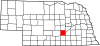
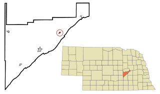
Trumbull is a village in Clay and Adams counties in Nebraska, United States. The population was 198 at the 2020 census. It is part of the Hastings, Nebraska Micropolitan Statistical Area.

References

  1. "ArcGIS REST Services Directory". United States Census Bureau. Retrieved September 18, 2022.
  2. 1 2 U.S. Geological Survey Geographic Names Information System: Doniphan, Nebraska
  3. 1 2 "U.S. Census website". United States Census Bureau . Retrieved January 31, 2008.
  4. "Hall County". Center for Advanced Land Management Information Technologies. University of Nebraska.
  5. Fitzpatrick, Lillian L. (1960). Nebraska Place-Names. University of Nebraska Press. p. 70. ISBN   0-8032-5060-6. A 1925 edition is available for download at University of Nebraska—Lincoln Digital Commons.
  6. oldsaybrookhistory@gmail.com. "Looking Back: When shad was king in the Connecticut River". CT Insider. Retrieved March 22, 2024.
  7. August F. Buechler; Robert J. Barr; Dale P. Stough (1920). History of Hall County, Nebraska: A Narrative of the Past with Special Emphasis Upon the Pioneer Period of the County's History, and Chronological Presentation of Its Social, Commercial, Educational, Religious, and Civic Development from the Early Days to the Present Time, and Special Analysis of Its Military and Civil Participation in the Late World War. Western Publishing and Engraving Company. p.  134.
  8. "US Gazetteer files 2010". United States Census Bureau. Archived from the original on July 2, 2012. Retrieved June 24, 2012.
  9. "Census of Population and Housing". Census.gov. Retrieved June 4, 2015.
  10. "U.S. Census website". United States Census Bureau . Retrieved June 24, 2012.
  11. "Explore Doniphan-Trumbull Secondary School". Niche. Retrieved July 17, 2020.