Sheringham is an English seaside town within the county of Norfolk, United Kingdom. The motto of the town, granted in 1953 to the Sheringham Urban District Council, is Mare Ditat Pinusque Decorat, Latin for "The sea enriches and the pine adorns".

Holt is a market town, civil parish and electoral ward in the English county of Norfolk. The town is 22.8 miles (36.7 km) north of the city of Norwich, 9.5 miles (15.3 km) west of Cromer and 35 miles (56 km) east of King's Lynn. The town is on the route of the A148 King's Lynn to Cromer road. The nearest railway station is in the town of Sheringham where access to the national rail network can be made via the Bittern Line to Norwich. Holt also has a railway station on the preserved North Norfolk Railway, the 'Poppy Line', of which it is the south-western terminus. The nearest airport is Norwich. The town has a population of 3,550, rising and including the ward to 3,810 at the 2011 census. Holt is within the area covered by North Norfolk District Council.

Cromer is a coastal town and civil parish on the north coast of the English county of Norfolk. It is 23 miles north of Norwich, 116 miles north-northeast of London and four miles east of Sheringham on the North Sea coastline. The local government authorities are North Norfolk District Council, whose headquarters is on Holt Road in the town, and Norfolk County Council, based in Norwich. The civil parish has an area of 4.66 km2 and at the 2011 census had a population of 7,683.

Overstrand is a village on the north coast of Norfolk in England, two miles east of Cromer. It was once a modest fishing station, with all or part of the fishing station being known as Beck Hythe. In the latter part of the 19th century it was catapulted into prominence, and became known as “the village of millionaires”.

Beeston Regis is a village and civil parish in the North Norfolk district of Norfolk, England. It is about a mile (2 km) east of Sheringham, Norfolk and near the coast. The village is 2 miles (3 km) west of Cromer and 16 miles (26 km) north of the city of Norwich. According to the 2011 census it had a population of 1,062. There is a frequent bus service on the coast road A149 and a rail service from the nearby stations of Sheringham to the west and West Runton to the east, where the Bittern Line runs a frequent service between Norwich, Cromer and Sheringham. The nearest airport is Norwich International Airport.

Sloley is a village and a civil parish in the English county of Norfolk. The village is 11.9 miles (19.2 km) north-north-east of Norwich, 13.6 miles (21.9 km) south-south-east of Cromer and 128 miles (206 km) northeast of London. The village lies 4.7 miles (7.6 km) south of the town of North Walsham. Worstead railway station, on the Bittern Line between Cromer and Norwich, is about 1 km (0.62 mi) from the centre of the village. The nearest airport is Norwich International Airport. The parish had a population of 257 at the 2011 Census.
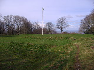
Beacon Hill is the highest point in the English county of Norfolk. The hill is located 0.75 miles (1.2 km) south of the village of West Runton on the North Norfolk coast. At its summit the hill is 105 metres (344 ft) above sea level. The hill is also known as Roman Camp. The summit and surrounding woodlands are now in the care of the National Trust. A track, named Calves Well Lane, running west from Sandy Lane leads to a car park which is maintained by donations made to the National Trust collection box provide on the edge of the car park. Litter bins and benches make Beacon Hill an ideal location for picnics. There are several footpaths to follow across the area.

West Runton railway station is on the Bittern Line in Norfolk, England, serving the village of West Runton. It is 28 miles 55 chains (46.2 km) down the line from Norwich and is situated between Cromer and Sheringham, the northern terminus.

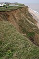
West Runton is a village in North Norfolk, England, on the North Sea coast.
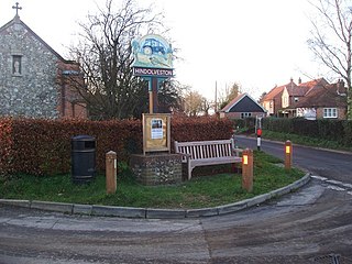
Hindolveston is a village and civil parish in the English county of Norfolk. The village is 17.5 miles (28.2 km) west-south-west of Cromer, 20.8 miles (33.5 km) north north west of Norwich and 122 miles (196 km) north east of London. The village lies 8.4 miles (13.5 km) south of the town of Holt.

Briningham is a village and a civil parish in the English county of Norfolk. The village is 9.9 miles east north east of the town of Fakenham, 13.3 miles west south west of Cromer, 22.3 miles north north west of the city of Norwich, and 124 miles north north east of London. The nearest railway station is at Sheringham for the Bittern Line which runs between Sheringham, Cromer and Norwich. There is an abandoned railway line which is considered as a footpath, it runs parallel with an old track "the lane" that leads up to "belle vue tower". The nearest airport is Norwich International Airport. The civil parish had in 2001 census a population of 122, increasing to 130 at the 2011 census. For the purposes of local government, the parish falls within the district of North Norfolk.

Kelling is a village and a civil parish in the English county of Norfolk. The village is 10.1 miles (16.3 km) west of Cromer, 26 miles (42 km) north of Norwich, and 130 miles (210 km) northeast of London. The village straddles the A149 Coast road between Kings Lynn and Great Yarmouth.
Roughton is a village and a civil parish in the English county of Norfolk. The village is 3.7 miles (6.0 km) south of Cromer, 19.6 miles (31.5 km) north of Norwich, and 6.5 miles (10.5 km) north-west of North Walsham. It straddles the A140 between Cromer and Norwich and the B1463.
James Leak was a bare-knuckle prize fighter who was born in the county of Norfolk in the United Kingdom.

Hickling is a village and a civil parish in the English county of Norfolk. The village is 22 miles south-east of Cromer, 20.3 miles north-east of Norwich and 137 miles north-east of London. The village lies 3 miles east of the Broadlands town of Stalham. The nearest railway station is at Worstead for the Bittern Line which runs between Sheringham, Cromer and Norwich.

Ryburgh is a village and a civil parish in the English county of Norfolk. The village is 21.2 miles (34.1 km) south-west of Cromer, 23.1 miles (37.2 km) north-west of Norwich and 117 miles (188 km) north-east of London. The village lies 4 miles (6.4 km) south-east of the nearby town of Fakenham. The nearest railway station is at Sheringham for the Bittern Line which runs between Sheringham, Cromer and Norwich. The nearest airport is Norwich International Airport.

Smallburgh is a village and a civil parish in the English county of Norfolk. The village is fourteen miles (21 km) south-east of Cromer, fourteen miles (21 km) north-east of Norwich and 132 miles (212 km) north-east of London. The village lies five miles (8 km) south-east of the nearby town of North Walsham. The nearest railway station is at Worstead for the Bittern Line which runs between Sheringham, Cromer and Norwich. The nearest airport is Norwich International Airport. At the 2001 census it had a population of 518 in 219 households. For the purposes of local government, it falls within the district of North Norfolk.

East Runton Windmill is a grade II listed tower mill at East Runton, Norfolk, England which has been converted to residential accommodation.

RNLB Henry Blogg was the eighteenth lifeboat to be stationed at Cromer in the county of Norfolk.

Hunworth is a village within the civil parish of Stody in the English county of Norfolk. The village is 11.5 miles (18.5 km) east-north-east of the town of Fakenham, 12.6 miles (20.3 km) west-south-west of Cromer and 125 miles (201 km) north-north-east of London. The nearest town is Holt which lies 3.4 miles (5.5 km) north of the village. The nearest railway station is at Sheringham for the Bittern Line which runs between Sheringham, Cromer and Norwich. The nearest airport is Norwich International Airport. The village is situated on the road between Holt and Briston. The parish of Stody, within which Hunworth is located, had, in the 2001 census, a population of 101, being less than 100 at the 2011 Census. For the purposes of local government, the parish falls within the district of North Norfolk.