Eastern Isles

Last updated

Eastern Isles
Site of Special Scientific Interest
Great Ganilly and Great Innisvouls - geograph.org.uk - 1766024.jpg
View of a portion of the Eastern Isles
Isles of Scilly UK location map.svg
Red pog.svg
Location within Isles of Scilly
Location Cornwall
Grid reference SV947145
Coordinates 49°57′06″N6°15′24″W / 49.9517°N 6.2567°W / 49.9517; -6.2567
InterestBiological
Area83.8 hectares (0.838 km2; 0.324 sq mi)
Notification 1971 (1971)
Natural England website

The Eastern Isles (Cornish : Enesow Goonhyli, islands of the salt water downs) are a group of twelve small uninhabited islands within the Isles of Scilly Area of Outstanding Natural Beauty, part of the Scilly Heritage Coast and a Site of Special Scientific Interest (SSSI) first designated in 1971 for its flora and fauna. They have a long period of occupation from the Bronze Age with cairns and entrance graves through to Iron Age field systems and a Roman shrine on Nornour. [1] Before the 19th century, the islands were known by their Cornish name, which had also become the name of the largest island in the group after the submergence of the connecting lands. [2]

Contents

Geography

The islands are located to the south–east of St Martin's, and are within the Isles of Scilly Area of Outstanding Natural Beauty and part of the Scilly Heritage Coast. [3]

The Isles are not so exposed to gales as the Western Rocks; consequently the soils do not receive so much salt spray, and remnant habitats such as coastal grassland and maritime heath have survived the inundation of the sea. If the practice of summer grazing had continued, there would be even more grassland instead of the dense bramble which has smothered some of the small growing plants. [4]

The islands by area are:

Eastern Isles seen from Pentle Bay, Tresco Eastern Isles, Isles of Scilly.JPG
Eastern Isles seen from Pentle Bay, Tresco

Geology

The underlying rock is coarse grained Hercynian granite topped by wind–blown sand. Some of the islands are linked with boulder ridges and sandy bars and at low tide can be viewed as one island. During the Roman occupation of England and Wales the area was a low–lying plain between St Mary's and St Martins and the present Eastern Isles small hills. [4] The Isles of Scilly are a Geological Conservation Review (GCR) site for the largest assemblage of tied islands outside of Orkney and Shetland. Four islands represent the different stages in the linking of islands by a sandy bar or tombola and they are Teän (not part of the Eastern Isles) which is to the north–west, between St Martin's and Tresco; and Great Arthur, Great Ganinick and Little Ganinick which are to the south–east of St Martin's. [5]

Wildlife and ecology

Most of the islands have dense cover of bramble Rubus fruticosus and bracken Pteridium aquilinum and grassland along the coastal fringes. Goldenrod ( Solidago virgaurea ) is locally abundant amongst the heath communities growing on the podzolic soils on the higher parts of the islands. The heaths are classified as a poor fit somewhere between H10 and H11 and the heather ( Calluna vulgaris ), bell heather ( Erica cinerea ) and bracken merge into pure bracken on the lower slopes. A feasibility study is needed to decide if the vegetation would benefit from grazing through a Higher Level Stewardship (HLS) agreement. [6] [7] With no resident botanist, together with the difficulty of recording on remote islands, there are not many plant records and the number of species for each of the Eastern Isles was finally published in 1971 from surveys carried out by J D Grose, Mr & Mrs J E Dallas and J E Lousley in 1938 and 1939. Lousley listed 111 species of higher plants in his 1971 Flora, and by 1999 further surveys recorded a similar number (114). Some of the islands have species that are only found on that island and not on the other Eastern Isles such as an oak tree found by Mr and Mrs Dallas on Great Gannick. Possible ancient woodland indicators such as butcher's-broom ( Ruscus aculeatus ), wood spurge ( Euphorbia amygdaloides ) and wood small-reed ( Calamagrostis epigejos ) have also been recorded on Great Gannick. [4] [8] The nationally rare orange bird's-foot ( Ornithopus pinnatus ) is found on the northern side of Great Ganilly. [3]

The Eastern Isles are one of three main grey seal (Halichoerus grypus) pupping areas, Western Rocks and Norrard Rocks being the others. Four other mammals have been recorded: rabbit, brown rat described as a plague on some of the Eastern Isles, [9] house mouse and the so-called Scilly shrew. [4]

The isles are also home to breeding colonies of eight species of seabird; including three species of gull, as well as the common shag (Phalacrocorax aristotelis), great cormorant (Phalacrocorax carbo), northern fulmar (Fulmarus glacialis), razorbill (Alca torda) and puffin (Fratercula arctica). [3] Several of the isles are closed to visitors during the birds' breeding season (15 April to 20 August).

The islands

Great Ganilly

Great Ganilly Great Ganilly, Scilly - geograph.org.uk - 215325.jpg
Great Ganilly

Great Ganilly (Cornish : Goonhyli Meur, great salt water down) (grid reference SV947145 ), is the largest of the Eastern Isles and consists of two hills joined by a low sandy neck. The northern of the two hills has the highest point at 34 metres (112 ft) and has a ruined Bronze Age entrance grave on the summit. Stones from the chamber have been used to make a pyramidal navigational marker. [10] Other evidence of past occupation include a hut circle on the neck as well as the remains of field systems. [11] A freshwater spring would have made living on the island during the kelp burning season possible. The hills have maritime heath on each summit and dense bracken communities on the lower slopes. A total of seventy-four plant species were recorded in the surveys of 1938 and 1939; the largest number of species on any of the Eastern Isles and includes Portland and sea spurge, sea–kale and balm–leaved figwort in the small sand dune system. Common thyme and orange bird's–foot grow on the heath, which is dominated by bell heather ( Erica cinerea ). Betony ( Stachys officinalis ) which is a common plant in Cornwall but known from only two places in Scilly was discovered simultaneously here, and on Tresco in 1998, but was not seen in 2000. [12] Mammals recorded are rabbit, brown rat, house mouse and Scilly shrew. [4]

Great, Middle and Little Arthur

The Arthurs (Cornish : Ar Dhor, facing land) (grid reference SV942137 ), part of the Geological Conservation Review site (GCR), are three rocky islands joined by two beaches forming a crescent around Arthur Porth; compare with Great Ganinick and Little Ganinick (see below) where the process is ongoing. [5] Great Arthur, as the name suggests, is the largest with a fringe of maritime grassland, dune vegetation and strandline vegetation. There are three entrance graves on the summit ridge connected by a prehistoric boulder wall. [10] They are surrounded by maritime heath with English stonecrop on the bare areas. The area of blown sand is dominated by marram grass ( Ammophila arenaria ) which helps to stabilise the dunes and shelter a relatively rich flora of non-maritime plants such as a stunted grey sallow ( Salix cinerea ). This (probably the same) plant is recorded in both Louseley (1971) and Parslow (1997).

Middle Arthur has an unusual boat-shaped entrance grave on the summit with walls of standing slabs. A ceramic burial urn together with pieces of bone and flint were found during excavations in 1953. [10] The island as a few patches of heather and some strandline vegetation on the sheltered parts of its shore, while Little Arthur has bracken on the deeper soils and heath on the summit with English stonecrop in the bare areas. Also on Little Arthur is a small area of strandline vegetation and sand dunes with slender St John's-wort ( Hypericum pulchrum ); a plant common in Cornwall but uncommon in the Isles of Scilly. [4]

Menawethan

Menawethan (Cornish : Men an Wedhen, the tree stone) (grid reference SV954137 ), is a steep-sided island to the south–east of the group with vegetation that is typical of islands with breeding seabirds. It was one of the first islands where Natural England carried out rat eradication. Some areas are covered in hottentot fig (probably carried to the island by gulls); thrift and sea campion also dominate in some areas. Other species recorded include Yorkshire fog, orache, common scurvy-grass and tree-mallow which forms temporary stands in some years. Brookweed ( Samolus valerandi ), a plant restricted to cliff flushes in Cornwall and an unusual plant in Scilly, grows among rocks above the shore. The rocky shore is used by grey seal for haul outs. [4] There is a Bronze Age cairn on the summit. [1] The island is recorded as Mynangwython c1588. [2]

Little Ganilly

Little Ganilly (Cornish : Goonhyli Bian, little salt water down) (grid reference SV938142 ) is just to the north of Little Arthur and has a small area of heath on the summit. Bracken dominates the slopes and there are maritime grassland and cliff communities along the coast which has several small caves on the east side. [4] Surveys in 1938 and 1939 recorded 37 species of plants. [8] The only mammals recorded are brown rats and grey seals which use the island as a haul out.

Great Innisvouls and Little Innisvouls

Great Innisvouls (Cornish : Enys Vols Meur, great wether island) (grid reference SV953141 ), has a small area of maritime grassland and bracken, and Little Innisvouls (Cornish : Enys Vols Bian, little wether island) (grid reference SV955142 ) has strandline plant species. Both have breeding seabirds and the Scilly shrew has been recorded on Great Innisvouls. Gurney reported twelve pairs of shag with egg and one pair with young on Great Iinnisvouls on 12 May 1887. [13]

To the north–east of Little Innisvouls is a small rock called Mouls (Cornish : Mols, wether (a castrated male sheep)) (grid reference SV957144 ), where a nationally scarce pseudoscorpion, Neobisium maritimum was found in 1927. [4]

Great Ganinick and Little Ganinick

Great Ganinick and Little Ganinick Great Ganinick and Little Ganinick, Isles of Scilly - geograph.org.uk - 1766004.jpg
Great Ganinick and Little Ganinick

The islands of Great Ganinick and Little Ganinick (Cornish : Kenninek, place of wild garlic) (grid reference SV933139 ), are part of the GCR and are in an early stage of the linkage of two islands by a tombola. The sand bar is building from Little Ganinick, northwards, towards the larger island although the sand supply does not appear to be sufficient to link the two islands. On the north side of Great Ganinick a "cuspate" shaped beach is forming. [5] Great Ganinick has the only known oak tree in the Eastern Islands. Described by Mr and Mrs Dallas in 1938 as ″.... about 2 ft 6in (0.76 m) tall in tangle of bracken, bramble and honeysuckle. [8] It was still there (or possibly one like it) in 1997. [4] Great Ganinick is rich in plant species with 74 species recorded by Lousley including butcher's–broom, wood spurge, wood small–reed and white ramping–fumitory. Little Ganinick has grassland with strandline vegetation and seabird colonies. [4]

Nornour

Nornour (Cornish : Ar Nor, facing the mainland) (grid reference SV944148 ), consists of one hill covered in bracken to the north of Great Ganilly, joined to it at low tide by a boulder causeway. [4] There was a long period of habitation during the Bronze and Iron Ages when Nornour would have been part of a larger island; after a storm in 1962, the erosion of sand dunes uncovered hut circles. Eleven circular stone buildings were found, and the site was excavated in 1962–66 and 1969–73. Many features were found including doorways, dividing walls, steps, hearths, querns and stone-lined pits. Two of the buildings have since disappeared under beach boulders. [10] Among the numerous Roman finds found in the two western huts were more than three hundred brooches, dating from the later first to the later third century AD. [14] They were found in the upper layers of two of the prehistoric buildings, along with coins (late first to late fourth century), glass, miniature pots and pieces of small clay Gallic figurines. [1] The earliest coins are from Vespasian (AD 69–79) and the later date indicate that the site was still being used into the late fourth century. Analysis of the brooches indicate they came from numerous places in Britain and the Continent; given that there are no comparable sites on Scilly, this suggests that the finds were not for trade but perhaps for paying respect to a local cult. The finds indicate a shrine, and Sulis has been suggested. [1] [15] With dates ranging over four centuries, it is unlikely that the objects came from a shipwreck. [14] Despite attempts to protect the archaeological site sea erosion still occurs.

The boilers of the paddle steamer Earl of Arran can be seen at low tide on the western shore. She hit Irishman's Ledge (grid reference SV947149 ) on 16 July 1872, when the Captain attempted to take a short cut through English Island Neck. [16]

There is a small area of heath on the hill with heather and bell heather and in the disturbed area around the hut circles. The nationally scarce plants Portland spurge ( Euphorbia portlandica ) and balm–leaved figwort ( Scrophularia scorodonia ) have been recorded on Nornour, as has butcher's–broom, sea spurge ( Euphorbia paralias ) and sea spleenwort ( Asplenium marinum ) The endangered shore dock ( Rumex rupestris ) colony has not been seen since 1970. [8]

Ragged Island

Ragged Island (grid reference SV946138 ) has two unexpected plants; Chilean hard-fern ( Blechnum cordatum ) and borage ( Borago officinalis ). [4] It is not known how they got there, neither species was recorded by Lousley in his 1971 Flora, although spores from ferns can be blown some distance; Chilean hard-fern was recorded in Higher Town, St Martin's in 1936. [8] Other species recorded include thrift, scurvy grass, hastate orache and sea beet. [7]

Guther's

Guther's Island Guther's Island - geograph.org.uk - 815580.jpg
Guther's Island

Guther's (or Gunther's) (Cornish : Goothow, channels) (grid reference SV918144 ), is a small island which lies on the western side of the Eastern Isles and south of St Martin's. It has limited vegetation consisting of grass, docks and sea beet. Greater black-backed ( Larus marinus ) and herring gulls ( L. argentatus ) nest, as do common shags. [4] It is possible to walk out to this island from St Martin's at exceptional low tides, but great care must be taken not to be cut off.

Hanjague

Hanjague (Cornish : An Wynjek, the windy one) (grid reference SV957150 ) is a sea stack approximately one km north-east of Great Gannilly, and is the easternmost island in the archipelago. The island has no vegetation and is used as a roost by birds. [4]

English Island

The rock is between English Island point, St Martin's to the north, and Nornour to the south-east (grid reference SV939149 ). [16]

See also

Related Research Articles

<span class="mw-page-title-main">St Agnes, Isles of Scilly</span> Island in the Isles of Scilly, UK

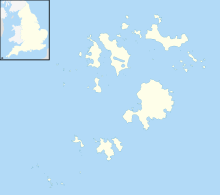
St Agnes is the southernmost populated island of the Isles of Scilly. Thus the island's Troy Town Farm is the southernmost settlement in the United Kingdom.

<span class="mw-page-title-main">St Martin's, Isles of Scilly</span> Island off Cornwall, England

St Martin's is the northernmost populated island of the Isles of Scilly, England, United Kingdom. It has an area of 237 hectares (0.92 sq mi).

<span class="mw-page-title-main">Annet, Isles of Scilly</span>

Annet is the second-largest of the fifty or so uninhabited Isles of Scilly, one kilometre west of St Agnes with a length of one kilometre and approximately 22 hectares in area. The low-lying island is almost divided in two by a narrow neck of land at West Porth which can, at times, be covered by waves. At the northern end of the island are the two granite carns of Annet Head and Carn Irish and three smaller carns known as the Haycocks. The rocky outcrops on the southern side of the island, such as South Carn, are smaller. Annet is a bird sanctuary and the main seabird breeding site in Scilly.

<span class="mw-page-title-main">Gugh</span> Tidal island of the isles of Scilly

Gugh could be described as the sixth inhabited island of the Isles of Scilly, but is usually included with St Agnes with which it is joined by a sandy tombolo known as "The Bar" when exposed at low tide. The island is only about 1 km (0.62 mi) long and about 0.5 km (0.31 mi) wide, with the highest point, Kittern Hill at 34 m (112 ft). The geology consists of Hercynian granite with shallow podzolic soils on the higher ground and deeper sandy soils on the lower ground. The former Gugh farm is just north of the neck across the middle of the island between the two hills. The two houses were designed and built in the 1920s by Charles Hamlet Cooper.

<span class="mw-page-title-main">St Helen's, Isles of Scilly</span>

St Helen's is one of the fifty or so uninhabited islands in the archipelago of the Isles of Scilly and has an approximate area of 0.1885 square kilometres. On the south side of the island is one of the earliest Christian sites in Scilly, an early medieval religious complex, which is thought to be the remains of St Elidius Hermitage, an 8th-century chapel lived in by Saint Lide,. There are also the remains of an isolation hospital used to quarantine sailors with plague. The island is the major part of a Site of Special Scientific Interest and some features have been given the designation of scheduled ancient monument. Access to the island is through chartered or private boat, although there are some season trips throughout the summer. St Helen's is currently managed by the Isles of Scilly Wildlife Trust.

<span class="mw-page-title-main">Teän</span>

Teän is an uninhabited island to the north of the Isles of Scilly archipelago between Tresco, 1.5 kilometres (0.9 mi) to the west, and St Martin's, 300 metres (330 yd) to the east. Approximately 16 hectares in area, the island consists of a series of granite tors with the highest point, Great Hill, rising to 40 metres (130 ft) at its eastern end. The low-lying land is overlain with glacial till and outwash gravels with glacial erratics abundant on the north coast beaches, which indicates the southern limit of outwash from an ice sheet for which it is designated a Geological Conservation Review site.

<span class="mw-page-title-main">Flora and fauna of Cornwall</span>

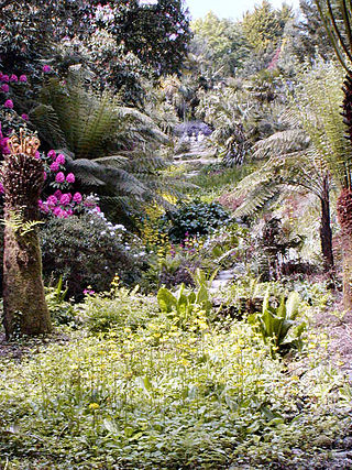
Cornwall is the county that forms the tip of the southwestern peninsula of England; this area has a mild and warm climate regulated by the Gulf Stream. The mild climate allows rich plant cover, such as palm trees in the far south and west of the county and in the Isles of Scilly, due to sub-tropical conditions in the summer.

<span class="mw-page-title-main">Rosevear</span> Island in the Isles of Scilly, United Kingdom

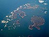
Rosevear is the largest of the group of rocks known as the Western Rocks, Isles of Scilly. The islands are on eastern side of the Atlantic Ocean on the south-west approaches to the island of Great Britain and are renowned for the numerous shipwrecks in the area and the nearby Bishop Rock lighthouse. All the uninhabited islands are owned by the Duchy of Cornwall and are managed by the Isles of Scilly Wildlife Trust, which looks after the archaeological and historical remains on the islands, as well as the flora and fauna. Landing is not allowed on the island.

<span class="mw-page-title-main">Birds of Cornwall</span>

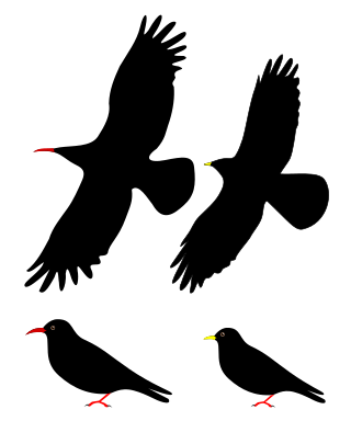
The birds of Cornwall are in general a selection of those found in the whole of the British Isles, though Cornwall's position at the extreme south-west of Great Britain results in many occasional migrants. The nightingale is one English bird which is virtually absent from Cornwall.

<span class="mw-page-title-main">White Island, Isles of Scilly</span> Island of Great Britain

White Island is one of the larger unpopulated islands of the Isles of Scilly, part of the United Kingdom, and lies off the coast of the northernmost populated island of the group, St Martin's, to which it is joined by a tidal causeway, or isthmus. The island is designated as a Site of Special Scientific Interest (SSSI) and a Geological Conservation Review site and is managed by the Isles of Scilly Wildlife Trust on behalf of the Duchy of Cornwall.

<span class="mw-page-title-main">Western Rocks, Isles of Scilly</span> Group of rocks in the Isles of Scilly, England, United Kingdom

The Western Rocks are a group of uninhabited skerries and rocks in the south–western part of the Isles of Scilly, United Kingdom, and are renowned for the numerous shipwrecks in the area and the nearby Bishop Rock lighthouse. In 1971, the rocks and islands were designated a Site of Special Scientific Interest for their breeding sea birds. Landing on the islands is both difficult and discouraged and there are few published records of visits by naturalists.

<span class="mw-page-title-main">Treen Cliff</span> Site of Special Scientific Interest on the Penwith Peninsula in Cornwall, England

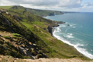
Treen Cliff is a Site of Special Scientific Interest (SSSI) located on the Penwith Peninsula in Cornwall, England, UK, 6 miles (9.7 km) south-west of Penzance. First notified in 1951, with a revision in 1973, and a further notification on 1 July 1986, it is 49.3 hectares in area, stretching from grid reference SW387220 to SW402225. Designated for both for its biological and geological interest, part of the site, Treryn Dinas, is a Scheduled Ancient Monument consisting of a "cliff castle" with four ramparts and ditches and the Logan Rock. It is within the Cornwall Area of Outstanding Natural Beauty (AONB), the Penwith Heritage Coast and is part owned and managed by the National Trust.

<span class="mw-page-title-main">Boscastle to Widemouth</span> Coastal Site of Special Scientific Interest in Cornwall, England

Boscastle to Widemouth is a coastal Site of Special Scientific Interest (SSSI) in Cornwall, England, noted for its biological and geological characteristics. The Dizzard dwarf oak woodland is unique and of international importance for its lichen communities, with 131 species recorded.

<span class="mw-page-title-main">Wingletang Down (St Agnes)</span>

Wingletang Down is a Site of Special Scientific Interest (SSSI) on the southern side of the island of St Agnes in the Isles of Scilly, England, UK, which is noted for its biological characteristics. The site is managed by the Isles of Scilly Wildlife Trust and is within the Isles of Scilly Heritage Coast and the Isles of Scilly Area of Outstanding Natural Beauty. It is the only site in Great Britain and Ireland for the small fern, least adder's–tongue. As of 11 September 2009 the SSSI was considered to be in ″unconditional recovering″ condition because European gorse and bramble are at unacceptable levels.

<span class="mw-page-title-main">Godrevy Head to St Agnes</span>

Godrevy Head to St Agnes is a coastal Site of Special Scientific Interest (SSSI) in north Cornwall, England], noted for both its biological and geological characteristics. A number of rare and scarce plant species can be found on the site, along with many breeding seabirds.

<span class="mw-page-title-main">Norrard Rocks</span>

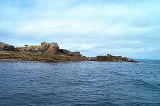
The Norrard (Northern) Rocks are a group of small uninhabited granite rocks in the north–western part of the Isles of Scilly, to the west of Bryher and Samson. In 1971 they were designated as a Site of Special Scientific Interest (SSSI) for their breeding seabird colonies and they are permanently closed to landings from boat passengers. The vegetation on the islands is limited by the extreme exposure and only six species of flowering plants have been recorded.

<span class="mw-page-title-main">Peninnis Head</span> Headland on St Marys, Isles of Scilly

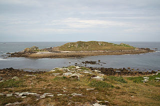
Peninnis Head is the southernmost point of St Mary's, Isles of Scilly. The headland is within the Isles of Scilly Area of Outstanding Natural Beauty and part of the Heritage Coast. It is also a Geological Conservation Review site for its Quaternary geomorphology and was first designated a Site of Special Scientific Interest (SSSI) in 1971 for both its biological and geological interests. On the tip of the headland is a squat lighthouse built in 1911 by Trinity House as a replacement for the 17th century lighthouse on St Agnes.

<span class="mw-page-title-main">Porth Hellick</span> Human settlement in England

Porth Hellick is a tidal inlet on the south coast of St Mary’s, the largest island in the Isles of Scilly.

<span class="mw-page-title-main">Poor's Allotment</span>

Poor's Allotment is a 28.57-hectare (70.6-acre) biological Site of Special Scientific Interest in Gloucestershire, notified in 1954. The site is listed in the 'Forest of Dean Local Plan Review' as a Key Wildlife Site (KWS).

Castle Down is a windswept plateau of maritime heath in the northern part of the island of Tresco, Isles of Scilly. The area has a number of designations including Castle Down (Tresco) Site of Special Scientific Interest (SSSI); is part of the Isles of Scilly Area of Outstanding Natural Beauty; part of the Isles of Scilly Heritage Coast; and part of Plantlife's Isles of Scilly Important Plant Area. There are a number of Schedule Ancient Monument's ranging in age from Bronze Age cairns to castles built in the 16th and 17th centuries to protect the anchorage of New Grimsby harbour.

References

  1. 1 2 3 4 Ratcliffe, Jeanette (1989). The Archaeology of Scilly. London: English Heritage. ISBN   1871162408.
  2. 1 2 Weatherhill, Craig, Place Names in Cornwall and Scilly, Wessex Books, 2005
  3. 1 2 3 "Eastern Isles" (PDF). Natural England. 5 December 1986. Archived from the original (PDF) on 24 October 2012. Retrieved 13 December 2011.
  4. 1 2 3 4 5 6 7 8 9 10 11 12 13 14 15 Parslow, Rosemary (2007). The Isles of Scilly. London: HarperCollins. ISBN   978-0-00-220151-3.
  5. 1 2 3 May, V J. "Isles of Scilly (Coastal Geomorphology of England)" (PDF). JNCC. Archived from the original (PDF) on 12 November 2016. Retrieved 31 December 2011.
  6. "Condition of SSSI units". Natural England. Retrieved 17 December 2011.[ permanent dead link ]
  7. 1 2 French, C N; Murphy R N; Atkinson, M (1999). Flora of Cornwall. Camborne: Wheal Seton Press.
  8. 1 2 3 4 5 Lousley, J E (1971). The Flora of the Isles of Scilly. Newton Abbot: David & Charles.
  9. Robinson, Peter (2003). Birds of the Isles of Scilly. London: Christopher Helm.
  10. 1 2 3 4 Sawyer, katharine (2007). "Scilly Through The Ages – The Eastern Isles". Scilly now & then. No. 10. p. 6.
  11. Historic England. "Prehistoric Regular Field System and Hut Circle on Great Ganilly (1014787)". National Heritage List for England . Retrieved 13 June 2017.
  12. Parslow, Rosemary (2001). "Plants on Scilly". Isles of Scilly Bird and Natural History Review 2000. 1.
  13. Gurney, J H. "Notes on the Isles of Scilly and the Manx Shearwater '(Puffinus anglorum)". Transactions of the Norfolk and Norwich Naturalists' Society. vi: 447–54. Retrieved 27 October 2012.
  14. 1 2 Butcher, Sarnia (2014). "The Roman brooches from Nornour, Isles of Scilly". Cornish Archaeology (53): 1–80.
  15. Thomas, Charles (1985). Exploration of a Drowned Landscape. ISBN   0-7134-4853-9.
  16. 1 2 Reid, Neil (2007). Isles of Scilly Guidebook. Cormorant Design. ISBN   1-904645-03-8.