Edgoten, Kentucky

Last updated

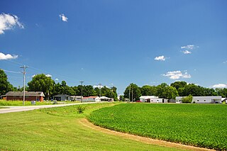
Edgoten is an unincorporated community in Christian County, in the U.S. state of Kentucky. [1]

Christian County, Kentucky County in the United States

Christian County is a county located in the U.S. state of Kentucky. As of the 2010 census, the population was 73,955. Its county seat is Hopkinsville. The county was formed in 1797.

U.S. state constituent political entity of the United States

In the United States, a state is a constituent political entity, of which there are currently 50. Bound together in a political union, each state holds governmental jurisdiction over a separate and defined geographic territory and shares its sovereignty with the federal government. Due to this shared sovereignty, Americans are citizens both of the federal republic and of the state in which they reside. State citizenship and residency are flexible, and no government approval is required to move between states, except for persons restricted by certain types of court orders. Four states use the term commonwealth rather than state in their full official names.

Kentucky State of the United States of America

Kentucky, officially the Commonwealth of Kentucky, is a state located in the east south-central region of the United States. Although styled as the "State of Kentucky" in the law creating it, (because in Kentucky's first constitution, the name state was used) Kentucky is one of four U.S. states constituted as a commonwealth. Originally a part of Virginia, in 1792 Kentucky became the 15th state to join the Union. Kentucky is the 37th most extensive and the 26th most populous of the 50 United States.
History

Edgoten had its start when the railroad was extended to that point. [2] The community's name is an amalgamation of "edge of Tennessee". [2] A post office called Edgoten was established in 1906, and remained in operation until 1922. [3]

Related Research Articles

Todd County, Kentucky County in the United States

Todd County is a county located in the U.S. state of Kentucky. As of the 2010 census, the population was 12,460. Its county seat is Elkton. The county is named for Colonel John Todd, who was killed at the Battle of Blue Licks in 1782 during the American Revolution.

Oak Grove, Kentucky City in Kentucky, United States

Oak Grove is a home rule-class city adjacent to the Fort Campbell army base in Christian County, Kentucky, in the United States. The population was 7,489 as of the 2010 U.S. Census. It is part of the Clarksville, Tennessee metropolitan area.

Cerulean is a census-designated place and unincorporated community in Trigg County, Kentucky, United States. At one time, it was a city, incorporated as Cerulean Springs. It lies along Kentucky Routes 124 and 126 northeast of the city of Cadiz, the county seat of Trigg County. Its elevation is 512 feet (156 m), and it is located at 36°57′34″N87°42′36″W. Although it is unincorporated, it has a post office, with the ZIP code of 42215.

Fearsville, Kentucky Unincorporated community in Kentucky, United States

Fearsville is an unincorporated community in Christian County, Kentucky, United States. Fearsville is located at 36°59′02″N87°21′27″W at an elevation of 558 feet. The community was named for the Fears family.

Gracey, Kentucky Census-designated place in Kentucky, United States

Gracey is an unincorporated community and census-designated place in Christian County, Kentucky, United States. As of the 2010 census it had a population of 138.

Ida, Virginia human settlement in United States of America

Ida is an unincorporated community in Page County, in the U.S. state of Virginia.

Orland is an unincorporated community in Swan Township, Vinton County, Ohio, in the United States.

Downingsville is an unincorporated community in Grant County, Kentucky, in the United States.

Gordonsville is an unincorporated community in Logan County, Kentucky, in the United States.

Keysburg is an unincorporated community in Logan County, Kentucky, in the United States.

Congleton is an unincorporated community in McLean County, in the U.S. state of Kentucky.

Herndon, Kentucky unincorporated community in Christian County, Kentucky, United States

Herndon is an unincorporated community located in Christian County, Kentucky, United States. It is concentrated around the intersection of Kentucky Route 107 and Kentucky Route 117, southwest of Hopkinsville. It has a post office with zip code 42236.

Wilmot, Indiana Unincorporated community in Indiana, United States

Wilmot is an unincorporated community in Washington Township, Noble County, in the U.S. state of Indiana.

Newstead is an unincorporated community in Christian County, in the U.S. state of Kentucky.

Cheap Hill is an unincorporated community in Cheatham County, in the U.S. state of Tennessee.

Mystic is an unincorporated community in Pennington County, in the U.S. state of South Dakota.

Fredericksburg is an unincorporated community in Gasconade County, in the U.S. state of Missouri.

Randolph Springs is an unincorporated community in Randolph County, in the U.S. state of Missouri.

Oak Grove is an unincorporated community in Trigg County, in the U.S. state of Kentucky.

References

  1. U.S. Geological Survey Geographic Names Information System: Edgoten, Kentucky
  2. 1 2 "Our Oldest Town". Kentucky New Era. June 6, 1974. p. 4. Retrieved 18 October 2015.
  3. "Christian County". Jim Forte Postal History. Retrieved 16 April 2015.

Coordinates: 36°38′30″N87°25′26″W / 36.64167°N 87.42389°W / 36.64167; -87.42389

Geographic coordinate system Coordinate system

A geographic coordinate system is a coordinate system that enables every location on Earth to be specified by a set of numbers, letters or symbols. The coordinates are often chosen such that one of the numbers represents a vertical position and two or three of the numbers represent a horizontal position; alternatively, a geographic position may be expressed in a combined three-dimensional Cartesian vector. A common choice of coordinates is latitude, longitude and elevation. To specify a location on a plane requires a map projection.