Crofton, Kentucky

Last updated

Crofton, Kentucky
Motto: 
Small Town... Big Heart
Christian County Kentucky Incorporated and Unincorporated areas Crofton Highlighted 2118658.svg
Location of Crofton in Christian County, Kentucky.
Coordinates: 37°2′52″N87°29′7″W / 37.04778°N 87.48528°W / 37.04778; -87.48528
Country United States
State Kentucky
County Christian
Area
[1]
  Total0.64 sq mi (1.64 km2)
  Land0.64 sq mi (1.64 km2)
  Water0.00 sq mi (0.00 km2)
Elevation
597 ft (182 m)
Population
 (2020)
  Total653
  Density1,028.35/sq mi (397.33/km2)
Time zone UTC-6 (Central (CST))
  Summer (DST) UTC-5 (CDT)
ZIP code
42217
Area code(s) 270 & 364
FIPS code 21-18658
GNIS feature ID0490363
Website www.croftonky.com

Crofton is a home rule-class city in Christian County, Kentucky, in the United States. The population was 653 as of the 2020 census, down from 749 at the 2010 census. [2]

Contents

Crofton is part of the Clarksville, TN KY Metropolitan Statistical Area.

History

Crofton had its start when the railroad was extended to that point. [3] Incorporated in 1873, the city is named for pioneer James Croft, the original owner of the town site. [4]

Geography

Crofton is located in northern Christian County at 37°2′52″N87°29′7″W / 37.04778°N 87.48528°W / 37.04778; -87.48528 (37.047752, -87.485260). [5] U.S. Route 41 passes through the center of town as Madisonville Street, and I-169 (formerly the Pennyrile Parkway) passes east of Crofton, with access from Exit 23. Hopkinsville, the Christian County seat, is 13 miles (21 km) to the south, and Madisonville is 22 miles (35 km) to the north.

According to the United States Census Bureau, Crofton has a total area of 0.6 square miles (1.6 km2), all land. [2]

Demographics

Historical population
CensusPop.Note
1880 136
1890 428214.7%
1900 278−35.0%
1910 40244.6%
1920 52731.1%
1930 461−12.5%
1940 68849.2%
1950 500−27.3%
1960 89278.4%
1970 631−29.3%
1980 82330.4%
1990 699−15.1%
2000 83819.9%
2010 749−10.6%
2020 653−12.8%
U.S. Decennial Census [6]

As of the census [7] of 2000, there were 838 people, 353 households, and 234 families residing in the city. The population density was 1,318.6 inhabitants per square mile (509.1/km2). There were 380 housing units at an average density of 598.0 per square mile (230.9/km2). The racial makeup of the city was 85.44% White, 12.65% African American, 0.12% Native American or Alaska Native, and 1.79% from two or more races. Hispanics or Latinos of any race were 0.24% of the population.

There were 353 households, out of which 30.9% had children under the age of 18 living with them, 44.2% were married couples living together, 17.0% had a female householder with no husband present, and 33.7% were non-families. 31.2% of all households were made up of individuals, and 14.7% had someone living alone who was 65 years of age or older. The average household size was 2.37 and the average family size was 2.96.

The age distribution was 25.5% under the age of 18, 7.0% from 18 to 24, 29.5% from 25 to 44, 21.0% from 45 to 64, and 16.9% who were 65 years of age or older. The median age was 37 years. For every 100 females, there were 76.1 males. For every 100 females age 18 and over, there were 77.3 males.

The median income for a household in the city was $25,625, and the median income for a family was $28,542. Males had a median income of $31,442 versus $17,109 for females. The per capita income for the city was $14,021. About 26.0% of families and 25.6% of the population were below the poverty line, including 33.1% of those under age 18 and 29.5% of those age 65 or over.

Related Research Articles

<span class="mw-page-title-main">Hopkins County, Kentucky</span> County in Kentucky, United States

Hopkins County is a county located in the western part of the U.S. state of Kentucky. As of the 2020 census, the population was 45,423. Its county seat is Madisonville. Hopkins County was created December 9, 1806 from Henderson County. It was named for General Samuel Hopkins, an officer in both the American Revolutionary War and War of 1812, and later a Kentucky legislator and U.S. Congressman.

<span class="mw-page-title-main">Samson, Alabama</span> City in Alabama, United States

Samson is a city in Geneva County, Alabama, United States. It is part of the Dothan, Alabama Metropolitan Statistical Area. At the 2020 census the population was 1,874, down from 1,940 in 2010. Samson incorporated in 1905, although other sources cited 1906.

<span class="mw-page-title-main">Corydon, Kentucky</span> City in Kentucky, United States

Corydon is a home rule-class city and former coal town in Henderson County, Kentucky, United States. The population was 720 at the 2010 census.

<span class="mw-page-title-main">Robards, Kentucky</span> City in Kentucky, United States

Robards is a home rule-class city in Henderson County, Kentucky, United States. The population was 515 at the 2010 census, down from 564 at the 2000 census.

<span class="mw-page-title-main">Hanson, Kentucky</span> City in Kentucky, United States

Hanson is a home rule-class city in Hopkins County, Kentucky, in the United States. The population was 742 at the 2010 census, up from 625 at the 2000 census.

<span class="mw-page-title-main">Madisonville, Kentucky</span> City in Kentucky, United States

Madisonville is a home rule-class city in and the county seat of Hopkins County, Kentucky, United States, located along Interstate 69 in the state's Western Coal Fields region. The population was 19,591 at the 2010 census. Madisonville is a commercial center of the region and is home to Madisonville Community College.

<span class="mw-page-title-main">Mortons Gap, Kentucky</span> City in Kentucky, United States

Mortons Gap is a home rule-class city in Hopkins County, Kentucky, in the United States. The population was 728 at the 2020 census, down from 863 at the 2010 census.

<span class="mw-page-title-main">Nebo, Kentucky</span> City in Kentucky, United States

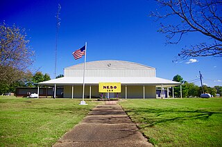
Nebo is a home rule-class city in Hopkins County, Kentucky, in the United States. The population was 236 as of the 2010 census.

<span class="mw-page-title-main">Nortonville, Kentucky</span> City in Kentucky, United States

Nortonville is a home rule-class city in Hopkins County, Kentucky, in the United States. The population was 1,204 as of the 2010 census.

<span class="mw-page-title-main">St. Charles, Kentucky</span> City in Kentucky, United States

St. Charles is a home rule-class city in Hopkins County, Kentucky, United States. The population was 277 at the 2010 U.S. Census.

<span class="mw-page-title-main">White Plains, Kentucky</span> City in Kentucky, United States

White Plains is a home rule-class city in Hopkins County, Kentucky, United States. The population was 884 at the 2010 census, up from 800 at the 2000 census.

<span class="mw-page-title-main">Green Spring, Kentucky</span> City in Kentucky, United States

Green Spring is a home rule-class city in Jefferson County, Kentucky, United States. The population was 715 at the 2010 census.

<span class="mw-page-title-main">Calhoun, Kentucky</span> City in Kentucky, United States

Calhoun is a home rule-class city in McLean County, Kentucky, United States. The population was 725 at the 2020 census. It is the county seat of McLean County. It is included in the Owensboro, Kentucky Metropolitan Statistical Area.

<span class="mw-page-title-main">Island, Kentucky</span> City in Kentucky, United States

Island is a home rule-class city in McLean County, Kentucky, in the United States. The population was 429 at the 2020 census. It is included in the Owensboro metropolitan area.

<span class="mw-page-title-main">Sacramento, Kentucky</span> City in Kentucky, United States

Sacramento is a home rule-class city in McLean County, Kentucky, in the United States. The population was 429 as of the 2020 census. It is included in the Owensboro metropolitan area.

<span class="mw-page-title-main">Drakesboro, Kentucky</span> City in Kentucky, United States

Drakesboro is a home rule-class city in Muhlenberg County, Kentucky, United States. The population was 481 at the 2020 census. Incorporated in 1888, the city was named for early pioneer William Drake.

<span class="mw-page-title-main">South Carrollton, Kentucky</span> City in Kentucky, United States

South Carrollton is a home rule-class city in Muhlenberg County, Kentucky, United States. The population was 141 at the 2020 census, down from 184 in 2010. Founded as "Randolph Old Farm" in 1838, an early pioneer changed the name of the city to honor his son, Carroll. The name was prefixed with "South" in order to distinguish it from the city of Carrollton.

<span class="mw-page-title-main">Waverly, Kentucky</span> City in Kentucky, United States

Waverly is a home rule-class city in Union County, Kentucky, United States. The population was 297 at the 2000 census. Founded in 1870, the city was named for founder Hugh McElroy's nephew.

<span class="mw-page-title-main">Madisonville, Texas</span> City in Texas, United States

Madisonville is a city in Madison County, Texas, United States. The population was 4,420 at the 2020 census. It is the county seat of Madison County. Both the City of Madisonville and the County of Madison were named for U.S. President James Madison, the fourth chief executive.

<span class="mw-page-title-main">Dawson Springs, Kentucky</span> City in Kentucky, United States

Dawson Springs is a home rule-class city in Hopkins and Caldwell counties in the U.S. state of Kentucky. As of the 2020 census, the population of the city was 2,452.

References

  1. "2020 U.S. Gazetteer Files". United States Census Bureau. Retrieved March 18, 2022.
  2. 1 2 "Geographic Identifiers: 2010 Demographic Profile Data (G001): Crofton city, Kentucky". U.S. Census Bureau, American Factfinder. Archived from the original on February 12, 2020. Retrieved August 11, 2014.
  3. "Our Oldest Town". Kentucky New Era. June 6, 1974. p. 4. Retrieved October 18, 2015.
  4. "Dictionary of Places: Crofton". Encyclopedia of Kentucky. New York, New York: Somerset Publishers. 1987. ISBN   0-403-09981-1.
  5. "US Gazetteer files: 2010, 2000, and 1990". United States Census Bureau. February 12, 2011. Retrieved April 23, 2011.
  6. "Census of Population and Housing". Census.gov. Retrieved June 4, 2015.
  7. "U.S. Census website". United States Census Bureau . Retrieved January 31, 2008.