Fairview, Kentucky

Last updated

Fairview, Kentucky
Jefferson Davis Memorial.jpg
Jefferson Davis Monument in Fairview
USA Kentucky location map.svg
Red pog.svg
Fairview
Coordinates: 36°50′36″N87°18′14″W / 36.84333°N 87.30389°W / 36.84333; -87.30389
Country Flag of the United States.svg  United States
State Flag of Kentucky.svg  Kentucky
County Christian
Area
[1]
  Total1.21 sq mi (3.13 km2)
  Land1.21 sq mi (3.13 km2)
  Water0.00 sq mi (0.00 km2)
Elevation
640 ft (195 m)
Population
 (2020)
  Total258
  Density213.75/sq mi (82.54/km2)
ZIP code
42266
GNIS feature ID0491893 [2]

Fairview is a small census-designated place on the boundary between Christian and Todd counties in the western part of the U.S. state of Kentucky. As of the 2020 census, the population was 258, down from the 2010 census total of 286, [3] with 186 living in Christian County and 100 living in Todd County. [4] It is chiefly notable as the birthplace of Jefferson Davis, later President of the Confederate States of America, and as the location of the Jefferson Davis State Historic Site.

Contents

History

The community was likely first established by Samuel Davis, a Revolutionary War veteran who settled on the Todd County side around 1793. Davis opened the first post office there on October 1, 1802, naming the locale "Davisburg." His son, Jefferson Davis, the future President of the Confederate States of America, was born here on June 3, 1808. [5]

The Davis family remained in the area until 1810, when they relocated to the Bayou Teche in St. Mary Parish, Louisiana. [6] The community was later known as "Georgetown" after local tavern keeper George Nichols. The town was incorporated as "Fairview" on February 6, 1846; the Fairview Post Office opened on the Christian County side on June 8. The post office moved back and forth between Christian and Todd counties over the years; in the early 1980s it was located on the Christian County side. [5]

In the 1880s ten Fairview locals purchased the old Davis property as a new home for Bethel Baptist Church. Working with Jefferson Davis, the buyers ceremonially deeded the lot to him, and he in turn donated it to Bethel Baptist Church on March 10, 1886. The old Davis homestead was demolished and replaced with a new Gothic Revival church. This burned down in 1900, and the present building was erected on the site the following year. [7] [8]

In 1917, construction of the Jefferson Davis State Historic Site began. It was completed in 1924.

Geography

Fairview is located along U.S. Route 68 / Kentucky Route 80, about 10 miles (16 km) east of Hopkinsville and 9 miles (14 km) west of Elkton. The original route of U.S. 68 passed through the town; the new route passes less than 0.25 miles (0.40 km) north of the town, and the original route is now called Jefferson Davis Road. [9] The community is part of the Clarksville, TN KY Metropolitan Statistical Area.

Demographics

Historical population
CensusPop.Note
2010 286
2020 258−9.8%
U.S. Decennial Census [10]

Related Research Articles

<span class="mw-page-title-main">Jefferson County, West Virginia</span> County in West Virginia, United States

Jefferson County is located in the Shenandoah Valley in the Eastern Panhandle of West Virginia. It is the easternmost county of the U.S. state of West Virginia. As of the 2020 census, the population was 57,701. Its county seat is Charles Town. The county was founded in 1801, and today is part of the Washington metropolitan area.

<span class="mw-page-title-main">Jackson County, Missouri</span> County in Missouri, United States

Jackson County is located in the western portion of the U.S. state of Missouri, on the border with Kansas. As of the 2020 census, the population was 717,204. making it the second-most populous county in the state.

<span class="mw-page-title-main">Wilkinson County, Mississippi</span> County in Mississippi, United States

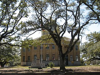
Wilkinson County is a county located in the southwest corner of the U.S. state of Mississippi. As of 2020, its population was 8,587. Its county seat is Woodville. Bordered by the Mississippi River on the west, the county is named for James Wilkinson, a Revolutionary War military leader and first governor of the Louisiana Territory after its acquisition by the United States in 1803.

<span class="mw-page-title-main">Todd County, Kentucky</span> County in Kentucky, United States

Todd County is a county located in the U.S. state of Kentucky. As of the 2020 census, the population was 12,243. Its county seat is Elkton. The county is named for Colonel John Todd, who was killed at the Battle of Blue Licks in 1782 during the American Revolution.

<span class="mw-page-title-main">Fayette County, Kentucky</span> County in Kentucky, United States

Fayette County is located in the central part of the U.S. state of Kentucky and is consolidated with the city of Lexington. As of the 2020 census, the population was 322,570, making it the second-most populous county in the commonwealth. Since 1974, its territory, population and government have been shared with Lexington. Fayette County is part of the Lexington-Fayette, KY Metropolitan Statistical Area.

<span class="mw-page-title-main">Christian County, Kentucky</span> County in Kentucky, United States

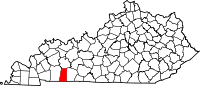
Christian County is a county located in the U.S. state of Kentucky. As of the 2020 census, the population was 72,748. Its county seat is Hopkinsville. The county was formed in 1797. Christian County is part of the Clarksville, Tennessee–Kentucky Metropolitan Statistical Area.

<span class="mw-page-title-main">Butler County, Kentucky</span> County in Kentucky, United States

Butler County is a county located in the US state of Kentucky. As of the 2020 Census, the population was 12,371. Its county seat is Morgantown. The county was formed in 1810, becoming Kentucky's 53rd county. Butler County is included in the Bowling Green, Kentucky, Metropolitan Statistical Area.

<span class="mw-page-title-main">Irwin County, Georgia</span> County in Georgia, United States

Irwin County is a county located in the U.S. state of Georgia. As of the 2020 census, the population was 9,666. The county seat is Ocilla. The county was created on December 15, 1818. It was named for Governor Jared Irwin.

<span class="mw-page-title-main">Jefferson Davis Parish, Louisiana</span> Parish in Louisiana, United States

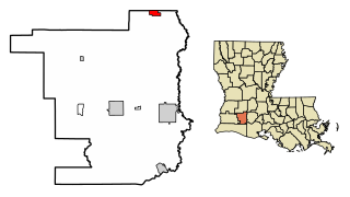
Jefferson Davis Parish is a parish located in the U.S. state of Louisiana. As of the 2020 census, the population was 32,250. The parish seat is Jennings. Jefferson Davis Parish is named after the president of the Confederacy during the American Civil War, Jefferson Davis. It is located in southwestern Louisiana and forms a part of the Acadiana region.

<span class="mw-page-title-main">Mount Washington, Kentucky</span> City in Kentucky, United States

Mount Washington is a home rule-class city in northeast Bullitt County, Kentucky, in the United States. The population was 18,090 at the 2020 census. The city is one of several surrounding Louisville that have experienced a sharp rise in population in the past three decades, becoming a commuter town.

<span class="mw-page-title-main">Princeton, Kentucky</span> City in Kentucky, United States

Princeton is a home rule-class city in Caldwell County, Kentucky, in the United States. It is the seat of its county. The population was 6,329 during the 2010 U.S. Census. Princeton is home to several notable attractions such as Adsmore Museum, Champion-Shepherdson House, University of Kentucky Research and Education Center Botanical Garden, Capitol Cinemas, the Annual Black Patch Festival, and Newsom's Aged Kentucky Ham.

<span class="mw-page-title-main">Hopkinsville, Kentucky</span> City in Kentucky, United States

Hopkinsville is a home rule-class city in and the county seat of Christian County, Kentucky, United States. The population at the 2020 census was 31,180.

<span class="mw-page-title-main">LaFayette, Kentucky</span> City in Kentucky, United States

LaFayette, also informally written as La Fayette and Lafayette, is a home rule-class city in Christian County, Kentucky, in the United States. The population was 177 as of the 2020 census, up from 165 in the 2010 U.S. census. LaFayette is part of the Clarksville, Tennessee metropolitan area.

<span class="mw-page-title-main">Columbus, Kentucky</span> City in Kentucky, United States

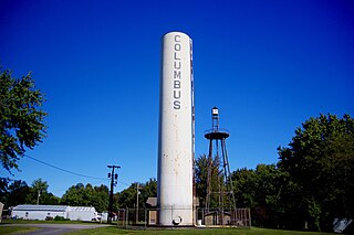
Columbus is a home rule-class city in Hickman County, Kentucky, in the United States. The population was 170 at the 2010 census, a decline from 229 in 2000. The city lies at the western end of the state, less than a mile from the Mississippi River.

<span class="mw-page-title-main">Mount Sterling, Kentucky</span> City in Kentucky, United States

Mount Sterling, often written as Mt. Sterling, is a home rule-class city in Montgomery County, Kentucky, United States. The population was 7,558 as of the 2020 census, up from 6,895 in 2010. It is the county seat of Montgomery County and the principal city of the Mount Sterling micropolitan area.

<span class="mw-page-title-main">Elton, Louisiana</span> Town in Louisiana, United States

Elton is a town in Jefferson Davis Parish, Louisiana, United States. The population was 992 at the 2020 census, down from 1,128 at the 2010 census. It is part of the Jennings Micropolitan Statistical Area.

<span class="mw-page-title-main">Jennings, Louisiana</span> City in Louisiana, United States

Jennings is a city in, and the parish seat of, Jefferson Davis Parish, Louisiana, United States, near Lake Charles. The population was 10,383 at the 2010 census, a small decline from the 2000 tabulation.

<span class="mw-page-title-main">Boyd County, Kentucky</span> County in Kentucky, United States

Boyd County is a county located in the U.S. state of Kentucky. As of the 2020 census, its population was 48,261. The county seat is Catlettsburg, and its largest city is Ashland. The county was formed in 1860. The county spans 160 square miles (410 km2), and is found at the northeastern edge of the state, near the Ohio River and Big Sandy River and situated in mountainous Appalachia. Boyd County is in the Huntington-Ashland, WV-KY-OH metropolitan statistical area.

<span class="mw-page-title-main">Bethel Baptist Church (Fairview, Kentucky)</span> Historic church in Kentucky, United States

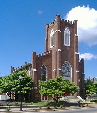
Bethel Baptist Church is a historic Southern Baptist church near U.S. Route 68 in Fairview, Kentucky. It occupies the site where Jefferson Davis, President of the Confederate States of America, was born in 1808. The current structure was built in 1901 and was added to the National Register of Historic Places in 1977.

References

  1. "2020 U.S. Gazetteer Files". United States Census Bureau. Retrieved March 18, 2022.
  2. "Fairview". Geographic Names Information System . United States Geological Survey, United States Department of the Interior . Retrieved July 17, 2009.
  3. "Profile of General Population and Housing Characteristics: 2010". United States Census Bureau. Archived from the original on February 12, 2020. Retrieved August 29, 2013.
  4. "Kentucky 2010: Population and Housing Unit Counts" (PDF). United States Census Bureau. p. 38. Retrieved August 29, 2013.
  5. 1 2 Rennick, Robert M. (1987). Kentucky Place Names. University Press of Kentucky. pp. 97–98. ISBN   0813126312 . Retrieved September 5, 2013.
  6. Leeper, Clare D'Artois (2012). Louisiana Place Names: Popular, Unusual, and Forgotten Stories of Towns. Louisiana State University Press. p. 132. ISBN   978-0807147382 . Retrieved August 29, 2013.
  7. Davis, Jefferson (1995). Strode, Hudson (ed.). Jefferson Davis: Private Letters, 1823-1889. Da Capo Press. p. 544. ISBN   0807147389 . Retrieved August 29, 2013.
  8. "Bethel Church Listed in Historic Register". Kentucky New Era . January 7, 1978. Retrieved August 29, 2013.
  9. Google (August 29, 2013). "Fairview, Kentucky" (Map). Google Maps . Google. Retrieved August 29, 2013.
  10. "Census of Population and Housing". Census.gov. Retrieved June 4, 2016.